

Surf Forecasts:

Kuta Reef surf forecast from 23 Jul 2026:
- Most powerful swell: Sunday 26 Jul, 5PM (local time) - 8ft (2.5m), 9s period, SE swell with 1,060 kJ wave energy.
Best Forecast Surf Conditions for Kuta Reef this week:
The most powerful waves expected at Kuta Reef in the next 16 days are 2.5m 9s and forecast to arrive on Sunday (Jul 26) at 5PM. Winds are predicted to be cross-offshore at the time the swell arrives. The largest open ocean swell (not directed at the beach) is 1.6m 8s period and expected on Monday (Jul 27) at 5AM.
| Wave Type | Time (WITA) & Date | Wave Height & Period |
|---|---|---|
| Next good surf (1 star+) | - | - |
| Best Surf | - | - |
| Most Powerful | 5PM (Sun 26th Jul) | 8ft (2.5m) 9s |
Table - best surf conditions forecast for Kuta Reef over the next 16 days.
The Lowdown
Alright crew, Rusty here. Let’s get into the forecast for Kuta Reef. This is a reef setup that loves a proper SW groundswell, and we’ve got some good energy lining up, but you’ll have to wait for the cleanest windows.
The water temperature is about normal for this time of year, nothing to write home about.
The first week is a bit of a struggle. From Friday the 24th through Tuesday the 29th, we’ve got a cross-off breeze from the ESE/SE blowing 15 to 22 mph. That’s putting a lot of texture on the surface. The swell is there, ranging from 3 ft to 8 ft, but the quality is poor. The 26th and 27th see a pulse of short-period SE swell, 3 ft to 8 ft, but with a period of only 8 to 9 seconds, it’s going to be a jumbled mess. The combined wave energy is moderate to strong (707 to 1263), but it’s just not working for the reef.
The real change starts on Wednesday the 30th. We start seeing longer-period SSW groundswells, 13 to 19 seconds, which is the magic ticket for this spot. The swell is a manageable 3 ft to 4 ft, and the energy is climbing (1008 to 1263). By the 31st, the wind drops to 12 to 15 mph, and the quality is improving.
But the absolute standout is the stretch from Monday, August 3rd through Thursday, August 6th. This is the one. We’ve got a consistent SSW groundswell running 5 ft to 6 ft, with a dreamy period of 15 to 17 seconds. The wind finally drops to a light breeze (6 to 12 mph) from the SE – still cross-off, but light enough to get that surface glassy. The wave energy is strong (1194 to 1903), and the reports are calling it excellent for experienced surfers. This is a long-period groundswell on a reef, so expect powerful, well-shaped waves. It’s a bit much for beginners, but for anyone with some time in the water, this is the week. The Thursday afternoon session on the 6th looks particularly tasty with that 5 ft, 17-second swell and light winds.
The following weekend (7th and 8th of August) still has some decent 5 ft to 6 ft swell, but the wind picks up a bit, so it’s not as clean as the early week.
So, the short story: the first week is a no-go for clean waves. Save your energy. The window from Monday, August 3rd to Thursday, August 6th is your best bet. The 5 ft to 6 ft SSW groundswell with a 15 to 17-second period and light winds is the real deal.
Rusty.
Short Range ForecastHeavy rain (total 24mm), heaviest during Sun night. Warm (max 25°C on Fri morning, min 24°C on Fri night). Mainly strong winds. | Days 4-6 Weather SummaryModerate rain (total 15mm), heaviest on Mon morning. Warm (max 25°C on Mon morning, min 25°C on Mon morning). Mainly strong winds. | ||||||||||||||||||||
Friday 24 | Saturday 25 | Sunday 26 | Monday 27 | Tuesday 28 | Wednesday 29 | Thursday 30 | |||||||||||||||
AM | PM | Night | AM | PM | Night | AM | PM | Night | AM | PM | Night | AM | PM | Night | AM | PM | Night | AM | PM | Night | |
Swell Height Map |  |  |  | 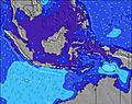 | 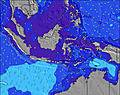 | 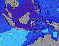 | 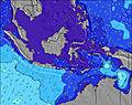 | ||||||||||||||
Wave Height (m) Direction Period (s) | SSW 13 | SSW 17 | SSW 16 | SSW 15 | SSW 14 | SE 8 | SE 9 | SE 9 | SE 9 | SE 8 | SE 8 | SE 8 | SSW 16 | SSW 16 | SSW 15 | SSW 15 | SSW 14 | SSW 13 | SSW 13 | SSW 19 | SSW 14 |
Wave Graph | |||||||||||||||||||||
246 | 372 | 917 | 639 | 536 | 719 | 826 | 1060 | 901 | 530 | 481 | 470 | 357 | 357 | 481 | 669 | 597 | 555 | 378 | 522 | 547 | |
Wind (km/h) | |||||||||||||||||||||
Wind State on-shore cross-onshore cross-shore cross-offshore off-shore glassy | cross-off | cross-off | cross-off | cross-off | cross-off | cross-off | cross-off | cross-off | cross-off | cross-off | cross-off | cross-off | cross-off | cross-off | cross-off | cross-off | cross-off | cross-off | cross-off | cross-off | cross-off |
High Tide | 6:07PM1.31m | 5:49AM1.94m | 8:38PM1.37m | 7:20AM1.96m | 9:35PM1.51m | 8:28AM2.06m | 10:07PM1.66m | 9:17AM2.20m | 10:34PM1.81m | 9:56AM2.33m | 11:00PM1.95m | 10:31AM2.44m | 11:25PM2.09m | ||||||||
Low Tide | 12:08PM0.94m | 10:16PM1.18m | 1:53PM0.86m | 00:16AM1.27m | 2:59PM0.71m | 2:03AM1.22m | 3:40PM0.55m | 3:04AM1.10m | 4:13PM0.42m | 3:48AM0.97m | 4:42PM0.30m | 4:25AM0.85m | 5:09PM0.22m | 4:59AM0.73m | |||||||
6:35 | — | — | 6:33 | — | — | 6:33 | — | — | 6:33 | — | — | 6:33 | — | — | 6:33 | — | — | 6:33 | — | — | |
— | 6:15 | — | — | 6:15 | — | — | 6:15 | — | — | 6:16 | — | — | 6:16 | — | — | 6:16 | — | — | 6:16 | — | |
mm | — | — | 1 | 1 | — | 5 | 4 | — | 13 | 4 | — | 4 | 2 | — | 3 | 2 | — | — | 1 | — | — |
Temp °C | 25 | 25 | 25 | 25 | 25 | 25 | 25 | 25 | 25 | 25 | 25 | 25 | 25 | 25 | 25 | 25 | 25 | 25 | 25 | 25 | 25 |
Feels °C | 22 | 23 | 23 | 23 | 23 | 22 | 22 | 23 | 22 | 21 | 22 | 22 | 23 | 23 | 23 | 23 | 23 | 23 | 24 | 23 | 24 |
Swell 1 Height (m) Direction Period (s) | SSW 13 | SSW 17 | SSW 16 | SSW 15 | SSW 14 | SSW 14 | SSW 13 | SSW 13 | SSW 13 | SSW 12 | SSW 17 | SSW 16 | SSE 8 | SSW 16 | SSW 15 | SSW 15 | SSW 14 | SSW 13 | SSW 13 | SSW 14 | SSW 14 |
246 | 372 | 917 | 639 | 536 | 336 | 257 | 201 | 198 | 86 | 168 | 149 | 155 | 357 | 481 | 669 | 597 | 555 | 378 | 449 | 527 | |
Swell 2 Height (m) Direction Period (s) | SSW 9 | SSW 13 | SW 18 | SW 18 | WSW 16 | SW 16 | SW 15 | S 20 | S 20 | SW 14 | SSW 12 | SSW 13 | SSW 16 | SW 12 | — | SW 24 | SSW 22 | SSW 21 | S 16 | SSW 19 | SE 6 |
61 | 186 | 12 | 12 | 25 | 40 | 33 | 8 | 7 | 46 | 51 | 106 | 357 | 22 | — | 22 | 50 | 89 | 251 | 522 | 94 | |
Swell 3 Height (m) Direction Period (s) | SSW 17 | SSW 9 | WSW 18 | — | NE 7 | NE 7 | NE 7 | S 20 | SSW 19 | SSW 18 | SW 13 | E 7 | SW 12 | NE 7 | — | SW 24 | — | NE 8 | SSW 20 | SSW 12 | SSW 18 |
235 | 62 | 31 | — | 2 | 2 | 2 | 8 | 36 | 61 | 44 | 1 | 23 | 2 | — | 22 | — | 9 | 216 | 145 | 547 | |
Wind waves Height (m) Direction Period (s) | SSE 7 | SSE 7 | SE 7 | SE 8 | SSE 8 | SE 8 | SE 9 | SE 9 | SE 9 | SE 8 | SE 8 | SE 8 | ESE 8 | SE 7 | SE 7 | SE 7 | SE 7 | SE 7 | SE 7 | SE 7 | — |
163 | 154 | 189 | 353 | 330 | 719 | 826 | 1060 | 901 | 530 | 481 | 470 | 248 | 309 | 336 | 309 | 253 | 187 | 147 | 147 | — | |
Nearest Offshore or Glassy | |||||||||||||||||||||
Distance (km) | 30 | 5 | 30 | 30 | 30 | 153 | 31 | 174 | 33 | 80 | 174 | 31 | 100 | 174 | 153 | 109 | 173 | 30 | 30 | 30 | 30 |
Best forecast wave conditions in Kuta - Bali | |||||||||||||||||||||
Best forecast wave conditions in Indonesia | |||||||||||||||||||||
Header Global | |||||||||||||||||||||
- Map Icons:
 Break
Break Live Wave Height (m)
 Live Wind Speed (km/h)
 Surf Rating (10 Max)
 Ocean Swells (m)
- Wind Speed (km/h)


FREE! Surf-Forecast.com widget for your website
The surf report / weather widget below is available to embed on third party websites free of charge and provides a summary of our Kuta Reef surf forecast. Simply grab the html code snippet that we provide and paste it into your own site. You can choose your preferred language and metric/imperial units for the surf forecast feed to suit users of your site. Click here to get the code.
Information about the Kuta Reef Surf forecast
The above surf forecast table for Kuta Reef provides essential information for determining whether the surfing conditions will be good over the next 16 days. A general guide to surfing at Kuta Reef can be found by selecting the local surf guide option on the grey menu. Our Kuta Reef surf forecast is unique since it includes wave energy (power) that defines the real feel of the surf rather than just the height or the period. If you surf the same spot (Kuta Reef) regularly then make a mental note of the wave energy from the surf forecast table each time you go. Very soon you may start to choose your surf days based on the wave energy alone combined with our forecast of favourable offshore wind conditions. Our star ratings will help here and of course you will also find the usual wave height and period predictions on our surf forecasts as well as a full break down of the swell components under our advanced users option (to reveal that, click the little Einstein character under the tide times).
Further information to help with frequently asked questions about our surf forecast for Kuta Reef may be found under the help tab on the top menu and also by moving your mouse over the question marks on the surf forecast table itself. Please always bear in mind that the forecast is for near-shore open water and local factors at each surf break influence the actual breaking wave height, such as the beach / reef profile, water depths offshore and shelter.
Kuta Reef is 1 km (1 miles) from the city of Kuta. If you plan a holiday in Kuta - Bali, look for hotels and other accommodation in Kuta. Kuta has rooms for a wide range of budgets as well as car hire and transport links.
 Nearest