

Surf Forecasts:

Agios Theologos (Kos) surf forecast from 20 Jul 2026:
- Most powerful swell: Saturday 25 Jul, 9PM (local time) - 7.5ft (2.3m), 7s period, NW swell with 498 kJ wave energy.
Best Forecast Surf Conditions for Agios Theologos (Kos) this week:
The most powerful waves expected at Agios Theologos (Kos) in the next 16 days are 2.3m 7s and forecast to arrive on Saturday (Jul 25) at 9PM. Winds are predicted to be cross-shore at the time the swell arrives. The largest open ocean swell (not directed at the beach) is 0.4m 5s period and expected on Thursday (Jul 23) at 12PM.
| Wave Type | Time (EEST) & Date | Wave Height & Period |
|---|---|---|
| Next good surf (1 star+) | - | - |
| Best Surf | - | - |
| Most Powerful | 9PM (Sat 25th Jul) | 7.5ft (2.3m) 7s |
Table - best surf conditions forecast for Agios Theologos (Kos) over the next 16 days.
The Lowdown
Alright, Rusty here. Let’s get straight into it. The next 16 days are looking pretty grim for the Kos region. We’ve got a long stretch of poor conditions ahead, so don’t be holding your breath for a good session.
Right off the bat, the only break on the radar is Agios Theologos (Kos) . It’s a beginner spot, inconsistent, and open to the north-northwest. The water temperature is sitting at 75°, which is about what you’d expect for this time of year – nothing wild there.
The first real chance of a wave comes on Monday the 20th of July, but it’s a write-off. We’re talking a tiny 2ft swell from the northwest, with a short, weak 4-second period. The wind is a cross-onshore breeze at 16 mph, making it choppy and messy. The combined energy is a measly (14) – basically flat. Not one to paddle out for.
Tuesday the 21st sees a bit more size, with 4ft to 4ft of north-northwest/northwest swell, but the wind picks up to 22 mph, still cross to cross-onshore. The period is still a short 5 seconds, and the energy is weak to moderate (56-62). The surf is described as poor, lumpy, and cross-chop. Honestly, it’s a mess.
Wednesday the 22nd through Friday the 24th is a repeat of the same story: small, weak swell (1ft to 4ft), short periods (3-5 seconds), and fresh onshore or cross-onshore winds. The energy never gets above 64, and it’s all “poor surf conditions.” You’d be better off doing something else.
Saturday the 25th of July is the closest we get to a stand-out, but even then, it’s not great. The swell bumps up to 5ft to 5ft from the northwest, with a period of 6 seconds. The combined energy finally hits moderate (147-155) – some actual push. But the wind is a fresh cross to cross-onshore breeze at 19 to 22 mph. The surf is lumpy and cross-chop. For a beginner spot, 5ft is a bit of a handful, and the wind is cruel. Not recommended.
The rest of the window from Sunday the 26th of July all the way to Tuesday the 4th of August is a total loss. The swell drops off, the wind stays onshore or cross, and the energy is virtually non-existent (0-89). There’s even a day of glassy calm on the 28th of July, but with no swell at all. That’s a cruel tease.
So, the honest truth: there are no good surf options in this 16-day window. The entire forecast is a blank run. The winds are persistent and wrong, the swell is either too small, too short-period, or both. It’s a tough stretch for the area, but it happens. Don’t force it. Keep an eye out for a change in the pattern.
Rusty.
Short Range ForecastMostly dry. Warm (max 28°C on Tue morning, min 24°C on Wed night). Winds decreasing (strong winds from the NW on Mon night, light winds from the W by Wed night). | Days 5-7 Weather SummaryMostly dry. Warm (max 25°C on Thu afternoon, min 22°C on Sat night). Winds increasing (moderate winds from the WNW on Fri night, strong winds from the NW by Sat afternoon). | |||||||||||||||||||
Mon 20 | Tuesday 21 | Wednesday 22 | Thursday 23 | Friday 24 | Saturday 25 | Sunday 26 | ||||||||||||||
PM | Night | AM | PM | Night | AM | PM | Night | AM | PM | Night | AM | PM | Night | AM | PM | Night | AM | PM | Night | |
Swell Height Map | 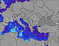 | 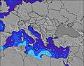 | 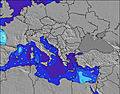 | 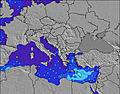 | 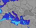 | 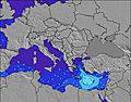 | 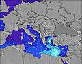 | |||||||||||||
Wave Height (m) Direction Period (s) | NW 4 | NNW 5 | NNW 5 | NW 5 | NW 4 | NW 4 | WNW 3 | WSW 3 | NW 3 | WNW 4 | NW 5 | NW 5 | NW 4 | NW 6 | NW 6 | NW 6 | NNW 6 | NNW 5 | NNW 5 | NW 4 |
Wave Graph | ||||||||||||||||||||
14 | 57 | 56 | 62 | 40 | 18 | 7 | 0 | 3 | 34 | 93 | 64 | 32 | 120 | 147 | 155 | 202 | 74 | 32 | 16 | |
Wind (km/h) | ||||||||||||||||||||
Wind State on-shore cross-onshore cross-shore cross-offshore off-shore glassy | cross-on | cross-on | cross | cross-on | cross-on | cross-on | cross-on | on | cross-on | cross-on | cross-on | cross-on | on | cross-on | cross | cross-on | cross | cross | cross-on | cross-on |
High Tide | 3:28PM0.10m | 5:08AM0.10m | 3:47PM0.08m | 6:18AM0.10m | 7:49AM0.10m | 9:06AM0.11m | 11:26PM0.06m | 10:01AM0.12m | 11:45PM0.07m | 10:43AM0.13m | 00:01AM0.08m | |||||||||
Low Tide | 10:11PM0.03m | 11:11AM0.06m | 10:26PM0.04m | 10:44PM0.05m | 5:03PM0.05m | 5:22PM0.04m | 2:35AM0.06m | 5:41PM0.03m | 3:52AM0.05m | 6:04PM0.02m | ||||||||||
— | — | 6:09 | — | — | 6:09 | — | — | 6:09 | — | — | 6:11 | — | — | 6:11 | — | — | 6:11 | — | — | |
8:28 | — | — | 8:27 | — | — | 8:27 | — | — | 8:25 | — | — | 8:24 | — | — | 8:24 | — | — | 8:23 | — | |
mm | — | — | — | — | — | — | — | — | — | — | — | — | — | — | — | — | — | — | — | — |
Temp °C | 27 | 27 | 28 | 28 | 28 | 27 | 28 | 28 | 24 | 25 | 24 | 24 | 24 | 24 | 23 | 25 | 25 | 23 | 24 | 24 |
Feels °C | 24 | 22 | 24 | 23 | 25 | 24 | 25 | 26 | 23 | 22 | 21 | 19 | 21 | 22 | 19 | 18 | 18 | 19 | 22 | 22 |
Swell 1 Height (m) Direction Period (s) | — | — | — | — | — | SW 4 | — | WSW 3 | WSW 4 | — | — | SW 6 | — | — | S 7 | — | — | — | — | — |
— | — | — | — | — | 1 | — | 1 | 1 | — | — | 1 | — | — | 1 | — | — | — | — | — | |
Swell 2 Height (m) Direction Period (s) | — | — | — | — | — | — | — | — | — | — | — | — | — | — | — | — | — | — | — | — |
— | — | — | — | — | — | — | — | — | — | — | — | — | — | — | — | — | — | — | — | |
Swell 3 Height (m) Direction Period (s) | — | — | — | — | — | — | — | — | — | — | — | — | — | — | — | — | — | — | — | — |
— | — | — | — | — | — | — | — | — | — | — | — | — | — | — | — | — | — | — | — | |
Wind waves Height (m) Direction Period (s) | NW 4 | NNW 5 | NNW 5 | NW 5 | NW 4 | NW 4 | WNW 3 | — | NW 3 | WNW 4 | NW 5 | NW 5 | NW 4 | NW 6 | NW 6 | NW 6 | NNW 6 | NNW 5 | NNW 5 | NW 4 |
14 | 57 | 56 | 62 | 40 | 18 | 7 | — | 3 | 34 | 93 | 64 | 32 | 120 | 147 | 155 | 202 | 74 | 32 | 16 | |
Nearest Offshore or Glassy | ||||||||||||||||||||
Distance (km) | 2722 | 2515 | 2515 | 2305 | 539 | 1953 | 2577 | 601 | 539 | 2799 | 398 | 1681 | 1655 | 601 | 398 | 2673 | 535 | 537 | 1312 | 599 |
Best forecast wave conditions in Aegean Sea | ||||||||||||||||||||
Best forecast wave conditions in Greece | ||||||||||||||||||||
Header Global | ||||||||||||||||||||
- Map Icons:
 Break
Break Live Wave Height (m)
 Live Wind Speed (km/h)
 Surf Rating (10 Max)
 Ocean Swells (m)
- Wind Speed (km/h)


FREE! Surf-Forecast.com widget for your website
The surf report / weather widget below is available to embed on third party websites free of charge and provides a summary of our Agios Theologos (Kos) surf forecast. Simply grab the html code snippet that we provide and paste it into your own site. You can choose your preferred language and metric/imperial units for the surf forecast feed to suit users of your site. Click here to get the code.
Information about the Agios Theologos (Kos) Surf forecast
The above surf forecast table for Agios Theologos (Kos) provides essential information for determining whether the surfing conditions will be good over the next 16 days. A general guide to surfing at Agios Theologos (Kos) can be found by selecting the local surf guide option on the grey menu. Our Agios Theologos (Kos) surf forecast is unique since it includes wave energy (power) that defines the real feel of the surf rather than just the height or the period. If you surf the same spot (Agios Theologos (Kos)) regularly then make a mental note of the wave energy from the surf forecast table each time you go. Very soon you may start to choose your surf days based on the wave energy alone combined with our forecast of favourable offshore wind conditions. Our star ratings will help here and of course you will also find the usual wave height and period predictions on our surf forecasts as well as a full break down of the swell components under our advanced users option (to reveal that, click the little Einstein character under the tide times).
Further information to help with frequently asked questions about our surf forecast for Agios Theologos (Kos) may be found under the help tab on the top menu and also by moving your mouse over the question marks on the surf forecast table itself. Please always bear in mind that the forecast is for near-shore open water and local factors at each surf break influence the actual breaking wave height, such as the beach / reef profile, water depths offshore and shelter.
Are you planning a holiday in Aegean Sea? If you are looking for accommodation near Agios Theologos (Kos), camping, hotels and holiday cottages in Aegean Sea, consider staying in Kos which is 15 km (9 miles) away. Other places in and around Aegean Sea where you can find information about places to rent, and car hire include Leros which is 50 km (31 miles) away, Bodrum, Patmos and Didim.
 Nearest