

Surf Forecasts:

Flume Beach surf forecast from 31 Jul 2026:
- Best quality surf: Saturday 1 Aug, 4PM (local time) - 10ft (3.0m), 17s period, SW swell with cross-offshore winds.
- Most powerful swell: Monday 3 Aug, 4PM (local time) - 15ft (4.5m), 13s period, SW swell with 6,737 kJ wave energy.
- Next surfable swell (1★+): Friday 31 Jul, 1PM (local time) - 7ft (2.1m), 12s period with SW swell.
Best Forecast Surf Conditions for Flume Beach this week:
The surf forecast for Flume Beach over the next 16 days: The first swell (rated 1 star or higher) is forecast to arrive on Friday (Jul 31) at 1PM. The primary swell is predicted to be 2.1m and 12s period with a secondary swell of 0.4m and 20s. The wind is predicted to be cross-offshore as the swell arrives.
The most powerful waves expected at Flume Beach in the next 16 days are 4.5m 13s and forecast to arrive on Monday (Aug 03) at 4PM. Winds are predicted to be cross-onshore at the time the swell arrives. The largest open ocean swell (not directed at the beach) is 3.0m 8s period and expected on Monday (Aug 03) at 10AM.
| Wave Type | Time (AEST) & Date | Wave Height & Period |
|---|---|---|
| Next good surf (1 star+) | 1PM (Fri 31st Jul) | 7ft (2.1m) 12s |
| Best Surf | 4PM (Sat 1st Aug) | 10ft (3.0m) 17s |
| Most Powerful | 4PM (Mon 3rd Aug) | 15ft (4.5m) 13s |
Table - best surf conditions forecast for Flume Beach over the next 16 days.
The Lowdown
Alright, Rusty here, let's size up the surf for the next couple of weeks.
We've got a run of solid, powerful SW groundswell on the way, but it is a mixed bag for the lineup. The first action kicks off this Friday morning, July 31st, and it's a classic case of "too much of a good thing" for most of the period. The standout window is actually a short, sweet spell early next week.
Friday, July 31st kicks things off at Flume Beach. It's a bit cloudy, with a light NNW cross-off breeze, and the swell is sitting at a solid 7 ft from the SW, pulsing with a 12-second period. The water temp is sitting at 57°, which is about normal for this time of year. The combined energy is strong (1350), and the waves look clean, but at 7 ft, it's already pushing into intermediate territory. Things get better in the afternoon as the sky clears and the wind drops to a glassy 5 km/h from the WSW. The swell drops a touch to 7 ft, but those glassy conditions (1517 combined energy) will make for some seriously good, clean lines for experienced surfers.
Saturday, August 1st, is the pick of the early run. A clear sky and a 15 km/h offshore wind from the north will groom the 6 ft SSW groundswell from a 17-second period into perfect shape. The energy is very strong (2462). This is a long-period swell, which means it will be powerful and better at a reef or point, but the offshore wind will make it work at Flume Beach. It's a morning for the experienced crew.
Sunday, August 2nd, the swell starts to get too big. We're looking at 10 ft from the SW on Sunday morning with a 25 km/h north offshore. The combined energy (3840) is massive. This is for experts only, and even then, the wind is getting strong. It stays big and clean-looking through Monday, August 3rd, but the wind clocks onshore in the afternoon, turning the 15 ft WSW swell into a choppy mess.
After that, things get a bit ordinary for a few days. The swell stays big, the wind gets messy, and the quality drops. You'll see a lot of "poor" and "marginal" flags in the forecast from Tuesday, August 4th through to Friday, August 7th. The swell is there, but it's either too big and onshore, or the wind is just wrong.
Then, Friday, August 7th offers another glimmer. A clear sky and a 15 km/h offshore wind from the NNE will be all over an 8 ft SW groundswell with a 17-second period. The combined energy (4188) is very strong. This is a solid, clean, powerful swell for those who can handle it. This is the second standout for the experienced crew.
The long-range forecast, out to August 15th, is a tale of two halves. The second week of August (from the 9th onwards) is dominated by relentless, powerful SW groundswells, but they are often accompanied by strong, messy winds. You'll see 15 ft to 16 ft swells with strong cross-onshore winds, which will be a complete washout for a paddle surfer. The energy values are through the roof (over 14000 on the 10th), but the conditions are just plain ugly. Honestly, the setup looks more interesting for the kite surfers through that second week than for the paddle crew. Stay patient, and look for a window in the first week.
Rusty.
Short Range ForecastLight rain (total 2mm), mostly falling on Sun night. Very mild (max 14°C on Sat afternoon, min 8°C on Sat morning). Winds increasing (calm on Fri afternoon, fresh winds from the NNW by Sun morning). | Days 4-6 Weather SummaryLight rain (total 9mm), mostly falling on Mon morning. Very mild (max 12°C on Tue morning, min 10°C on Tue night). Winds decreasing (fresh winds from the WSW on Mon night, calm by Wed night). | ||||||||||||||||||||
Friday 31 | Saturday 1 | Sunday 2 | Monday 3 | Tuesday 4 | Wednesday 5 | Thursday 6 | |||||||||||||||
AM | PM | Night | AM | PM | Night | AM | PM | Night | AM | PM | Night | AM | PM | Night | AM | PM | Night | AM | PM | Night | |
Swell Height Map |  |  |  | 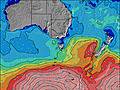 | 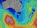 | 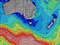 | 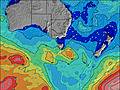 | ||||||||||||||
Wave Height (m) Direction Period (s) | SW 12 | SW 12 | SW 12 | SSW 17 | SW 17 | SW 16 | SW 16 | SW 15 | SW 15 | SW 15 | SW 13 | SW 12 | SW 12 | SW 11 | SW 11 | SW 15 | SW 13 | SW 17 | SW 16 | SW 16 | SW 15 |
Wave Graph | |||||||||||||||||||||
1200 | 1111 | 925 | 1796 | 4938 | 5469 | 3840 | 3357 | 2449 | 2390 | 6737 | 3869 | 2673 | 1949 | 1069 | 1446 | 839 | 805 | 1001 | 2445 | 2597 | |
Wind (km/h) | |||||||||||||||||||||
Wind State on-shore cross-onshore cross-shore cross-offshore off-shore glassy | cross-off | cross-on | off | off | cross-off | off | off | cross-off | cross-off | cross-on | cross-on | cross-on | on | on | cross-on | cross | cross-on | glassy | cross-off | glassy | off |
High Tide | 2:05PM0.97m | 1:17AM0.55m | 2:21PM0.95m | 1:52AM0.60m | 2:36PM0.91m | 2:26AM0.65m | 2:47PM0.85m | 3:01AM0.69m | 2:54PM0.79m | 3:38AM0.71m | 2:51PM0.74m | 4:19AM0.71m | 2:36PM0.71m | ||||||||
Low Tide | 8:46PM0.36m | 7:14AM0.12m | 8:52PM0.32m | 7:46AM0.15m | 9:01PM0.28m | 8:16AM0.20m | 9:11PM0.24m | 8:44AM0.28m | 9:21PM0.20m | 9:10AM0.38m | 9:31PM0.15m | 9:28AM0.49m | 9:44PM0.11m | ||||||||
7:33 | — | — | 7:31 | — | — | 7:31 | — | — | 7:30 | — | — | 7:28 | — | — | 7:28 | — | — | 7:26 | — | — | |
— | 5:39 | — | — | 5:39 | — | — | 5:40 | — | — | 5:42 | — | — | 5:43 | — | — | 5:44 | — | — | 5:45 | — | |
mm | — | — | — | — | — | — | — | — | 2 | 3 | 3 | 2 | 1 | — | — | — | — | — | — | — | — |
Temp °C | 11 | 12 | 12 | 13 | 14 | 12 | 14 | 14 | 11 | 11 | 11 | 11 | 12 | 12 | 11 | 11 | 12 | 12 | 12 | 12 | 11 |
Feels °C | 9 | 10 | 9 | 9 | 10 | 7 | 7 | 7 | 4 | 5 | 4 | 3 | 6 | 6 | 8 | 8 | 9 | 10 | 10 | 10 | 8 |
Swell 1 Height (m) Direction Period (s) | SW 12 | SW 12 | SW 12 | SSW 17 | SW 17 | SW 16 | SW 16 | SW 15 | SW 15 | SW 15 | — | SSW 18 | SW 12 | SW 11 | SW 11 | SW 15 | SW 13 | SW 12 | SW 16 | SW 16 | SW 15 |
1200 | 1111 | 925 | 1796 | 4938 | 5469 | 3840 | 3357 | 2449 | 2390 | — | 395 | 2673 | 1949 | 1069 | 1446 | 839 | 555 | 1001 | 2445 | 2597 | |
Swell 2 Height (m) Direction Period (s) | S 8 | SW 20 | SSW 18 | SW 12 | — | — | — | — | — | — | — | — | SSW 16 | SW 16 | SSW 21 | SSW 19 | SW 18 | SW 17 | SW 12 | S 8 | S 8 |
33 | 388 | 559 | 805 | — | — | — | — | — | — | — | — | 326 | 362 | 546 | 774 | 743 | 805 | 319 | 12 | 5 | |
Swell 3 Height (m) Direction Period (s) | SW 21 | SSE 7 | SSE 7 | — | — | — | — | — | — | — | — | — | — | — | SW 15 | — | SSW 7 | SSW 9 | S 8 | S 10 | — |
117 | 18 | 10 | — | — | — | — | — | — | — | — | — | — | — | 209 | — | 74 | 59 | 22 | 2 | — | |
Wind waves Height (m) Direction Period (s) | — | — | — | — | — | — | NNW 4 | NNW 4 | W 10 | W 8 | SW 13 | SW 12 | — | — | — | — | — | — | — | — | — |
— | — | — | — | — | — | 29 | 4 | 783 | 1158 | 6737 | 3869 | — | — | — | — | — | — | — | — | — | |
Nearest Offshore or Glassy | |||||||||||||||||||||
Distance (km) | 0 | 1 | 0 | 0 | 20 | 37 | 37 | 37 | 78 | 124 | 147 | 111 | 130 | 349 | 21 | 1 | 21 | 0 | 0 | 0 | 0 |
Best forecast wave conditions in Far West of Victoria | |||||||||||||||||||||
Best forecast wave conditions in Australia | |||||||||||||||||||||
Header Global | |||||||||||||||||||||
- Map Icons:
 Break
Break Live Wave Height (m)
 Live Wind Speed (km/h)
 Surf Rating (10 Max)
 Ocean Swells (m)
- Wind Speed (km/h)
Latest Updates


FREE! Surf-Forecast.com widget for your website
The surf report / weather widget below is available to embed on third party websites free of charge and provides a summary of our Flume Beach surf forecast. Simply grab the html code snippet that we provide and paste it into your own site. You can choose your preferred language and metric/imperial units for the surf forecast feed to suit users of your site. Click here to get the code.
Information about the Flume Beach Surf forecast
The above surf forecast table for Flume Beach provides essential information for determining whether the surfing conditions will be good over the next 16 days. A general guide to surfing at Flume Beach can be found by selecting the local surf guide option on the grey menu. Our Flume Beach surf forecast is unique since it includes wave energy (power) that defines the real feel of the surf rather than just the height or the period. If you surf the same spot (Flume Beach) regularly then make a mental note of the wave energy from the surf forecast table each time you go. Very soon you may start to choose your surf days based on the wave energy alone combined with our forecast of favourable offshore wind conditions. Our star ratings will help here and of course you will also find the usual wave height and period predictions on our surf forecasts as well as a full break down of the swell components under our advanced users option (to reveal that, click the little Einstein character under the tide times).
Further information to help with frequently asked questions about our surf forecast for Flume Beach may be found under the help tab on the top menu and also by moving your mouse over the question marks on the surf forecast table itself. Please always bear in mind that the forecast is for near-shore open water and local factors at each surf break influence the actual breaking wave height, such as the beach / reef profile, water depths offshore and shelter.
 Nearest