

Surf Forecasts:

Glenelg Rivermouth surf forecast from 3 Aug 2026:
- Best quality surf: Friday 7 Aug, 3AM (local time) - 10ft (3.0m), 16s period, SW swell with cross-offshore winds.
- Most powerful swell: Monday 10 Aug, 12AM (local time) - 28ft (8.5m), 16s period, WSW swell with 33,292 kJ wave energy.
- Next surfable swell (1★+): Wednesday 5 Aug, 6PM (local time) - 5ft (1.6m), 13s period with SW swell.
Best Forecast Surf Conditions for Glenelg Rivermouth this week:
The surf forecast for Glenelg Rivermouth over the next 16 days: The first swell (rated 1 star or higher) is forecast to arrive on Wednesday (Aug 05) at 6PM. The primary swell is predicted to be 1.6m and 13s period with a secondary swell of 1.1m and 18s. The wind is predicted to be cross-offshore as the swell arrives.
The most powerful waves expected at Glenelg Rivermouth in the next 16 days are 8.5m 16s and forecast to arrive on Monday (Aug 10) at 12AM. Winds are predicted to be cross-shore at the time the swell arrives. The largest open ocean swell (not directed at the beach) is 3.0m 10s period and expected on Sunday (Aug 09) at 3AM.
| Wave Type | Time (ACST) & Date | Wave Height & Period |
|---|---|---|
| Next good surf (1 star+) | 6PM (Wed 5th Aug) | 5ft (1.6m) 13s |
| Best Surf | 3AM (Fri 7th Aug) | 10ft (3.0m) 16s |
| Most Powerful | 12AM (Mon 10th Aug) | 28ft (8.5m) 16s |
Table - best surf conditions forecast for Glenelg Rivermouth over the next 16 days.
The Lowdown
Alright, let’s break it down. The next few days at Glenelg Rivermouth are a total washout. Monday and Tuesday are blown out with strong onshore winds and messy surf – don’t even think about it. There’s a dead stretch until Wednesday morning, when things start to ease up.
Wednesday the 5th and Thursday the 6th are just barely worth a look. Swell hangs around 6ft to 7ft from the SW, with light cross-shore breezes. The surface is a little bumpy but not horrible. The energy is moderate (2135 to 2218). You might snag a few, but it’s nothing to get excited about.
Now, Friday the 7th is the real deal. Morning brings a solid 10ft SW groundswell (period 15 seconds) with light NNW cross-offshore winds, making for clean conditions. The energy is strong (4874), but the swell is pushing too big for this break – it’s expert-only territory. The afternoon is the sweet spot: 8ft SW with the same long period, light N wind at 3 mph, and glassy water. This is a standout window for experienced surfers. The water temp is about 58°F, which is normal for this time of year.
Saturday the 8th stays clean with offshore N winds, but the swell is still 8ft to 8ft – still big, still for the skilled crew. The energy is moderate (2235 to 3431). It’s a good session if you’ve got the experience.
Then it all goes sideways. Sunday the 9th gets hammered by strong SW winds and a massive 15ft to 18ft swell – that’s dangerous, not surfable. That mess continues into the next week, with huge swell (up to 21ft on Monday the 10th) and cross-off winds, but it’s way too big for this spot. The energy readings are insane (22427, 15553), but that’s not a good thing here. This pattern of oversized swell runs through mid-month, with only brief windows of cleaner wind but wave heights that are just too much for the rivermouth.
The best bet in the whole outlook is Friday afternoon, the 7th of August. The 8ft SW groundswell, long 15-second period, and light offshore wind make for clean, powerful waves. It’s crowded sometimes, so get in early. This is a proper session for the experienced crew. After that, you’re waiting a long time for things to settle, but that one window is a beauty.
Rusty.
Short Range ForecastLight rain (total 8mm), mostly falling on Mon afternoon. Very mild (max 12°C on Mon night, min 8°C on Wed night). Wind will be generally light. | Days 4-6 Weather SummaryLight rain (total 9mm), mostly falling on Sat afternoon. Very mild (max 15°C on Sat morning, min 10°C on Sat afternoon). Winds increasing (calm on Thu night, fresh winds from the N by Sat afternoon). | ||||||||||||||||||||
Monday 3 | Tuesday 4 | Wednesday 5 | Thursday 6 | Friday 7 | Saturday 8 | Sunday 9 | |||||||||||||||
AM | PM | Night | AM | PM | Night | AM | PM | Night | AM | PM | Night | AM | PM | Night | AM | PM | Night | AM | PM | Night | |
Swell Height Map |  |  |  | 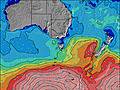 | 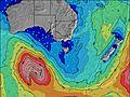 | 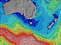 | 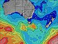 | ||||||||||||||
Wave Height (m) Direction Period (s) | SW 16 | WSW 14 | SW 13 | SW 12 | SW 11 | SW 11 | SW 14 | SW 13 | SW 17 | SW 16 | WSW 16 | SW 15 | SW 15 | SW 15 | SW 17 | SW 16 | SW 15 | SW 14 | W 10 | WSW 12 | WSW 16 |
Wave Graph | |||||||||||||||||||||
2314 | 4186 | 4401 | 3017 | 1903 | 1189 | 1521 | 1099 | 719 | 1571 | 1953 | 1760 | 3633 | 2717 | 3701 | 3415 | 2229 | 1712 | 4330 | 8247 | 33292 | |
Wind (km/h) | |||||||||||||||||||||
Wind State on-shore cross-onshore cross-shore cross-offshore off-shore glassy | cross-on | cross-on | cross-on | cross-on | cross-on | cross-on | cross | cross | cross-off | cross | cross-on | cross | cross-off | cross-off | off | off | off | cross-off | on | cross-on | cross |
High Tide | 2:22PM0.83m | 2:45AM0.67m | 2:30PM0.76m | 3:25AM0.70m | 2:27PM0.69m | 4:11AM0.70m | 2:03PM0.65m | 5:19AM0.69m | 1:02PM0.67m | 11:48AM0.76m | 11:47AM0.87m | ||||||||||
Low Tide | 8:49PM0.20m | 8:26AM0.28m | 8:59PM0.17m | 8:57AM0.38m | 9:09PM0.14m | 9:24AM0.50m | 9:20PM0.10m | 9:31AM0.63m | 9:33PM0.08m | 9:50PM0.07m | 10:16PM0.10m | ||||||||||
7:05 | — | — | 7:03 | — | — | 7:03 | — | — | 7:01 | — | — | 7:01 | — | — | 7:00 | — | — | 6:58 | — | — | |
— | 5:19 | — | — | 5:20 | — | — | 5:20 | — | — | 5:21 | — | — | 5:22 | — | — | 5:22 | — | — | 5:23 | — | |
mm | — | 1 | 2 | 2 | 2 | — | — | — | 1 | 1 | — | — | — | — | — | — | 3 | 5 | 4 | — | 2 |
Temp °C | 11 | 11 | 12 | 12 | 12 | 11 | 11 | 12 | 10 | 13 | 13 | 12 | 12 | 14 | 13 | 15 | 14 | 11 | 12 | 12 | 12 |
Feels °C | 4 | 5 | 7 | 7 | 8 | 7 | 7 | 9 | 6 | 11 | 11 | 11 | 10 | 12 | 7 | 9 | 7 | 7 | 2 | 4 | 7 |
Swell 1 Height (m) Direction Period (s) | SW 16 | SSW 13 | SW 18 | SW 16 | SW 15 | SW 11 | SW 14 | SW 13 | SW 13 | SW 16 | WSW 16 | SW 15 | SW 15 | SW 15 | SW 17 | SW 16 | SW 15 | SW 14 | SW 17 | SW 20 | — |
2314 | 1471 | 444 | 211 | 435 | 1189 | 1521 | 1099 | 459 | 1571 | 1953 | 1760 | 3633 | 2717 | 3701 | 3415 | 2229 | 1712 | 834 | 918 | — | |
Swell 2 Height (m) Direction Period (s) | SSW 14 | — | — | — | SW 20 | SW 20 | SW 19 | SW 18 | SW 17 | SSE 7 | WSW 20 | SW 18 | WSW 19 | SW 18 | — | SSW 9 | WNW 9 | SW 18 | SW 16 | — | — |
811 | — | — | — | 147 | 488 | 614 | 628 | 719 | 18 | 253 | 1336 | 1229 | 1533 | — | 16 | 352 | 460 | 865 | — | — | |
Swell 3 Height (m) Direction Period (s) | — | — | — | — | SW 21 | — | — | SSE 10 | SSE 8 | S 8 | S 8 | W 8 | SSE 8 | — | — | — | S 9 | SW 18 | SW 13 | — | — |
— | — | — | — | 112 | — | — | 9 | 54 | 12 | 12 | 74 | 12 | — | — | — | 6 | 314 | 406 | — | — | |
Wind waves Height (m) Direction Period (s) | WSW 8 | WSW 14 | SW 13 | SW 12 | SW 11 | — | — | — | NW 3 | — | — | — | — | — | N 3 | N 5 | N 6 | NW 10 | W 10 | WSW 12 | WSW 16 |
893 | 4186 | 4401 | 3017 | 1903 | — | — | — | 2 | — | — | — | — | — | 7 | 60 | 177 | 1201 | 4330 | 8247 | 33292 | |
Nearest Offshore or Glassy | |||||||||||||||||||||
Distance (km) | 246 | 266 | 246 | 294 | 450 | 61 | 9 | 9 | 0 | 61 | 67 | 9 | 20 | 0 | 0 | 189 | 189 | 456 | 61 | 294 | 246 |
Best forecast wave conditions in Far West of Victoria | |||||||||||||||||||||
Best forecast wave conditions in Australia | |||||||||||||||||||||
Header Global | |||||||||||||||||||||
- Map Icons:
 Break
Break Live Wave Height (m)
 Live Wind Speed (km/h)
 Surf Rating (10 Max)
 Ocean Swells (m)
- Wind Speed (km/h)
Latest Updates


FREE! Surf-Forecast.com widget for your website
The surf report / weather widget below is available to embed on third party websites free of charge and provides a summary of our Glenelg Rivermouth surf forecast. Simply grab the html code snippet that we provide and paste it into your own site. You can choose your preferred language and metric/imperial units for the surf forecast feed to suit users of your site. Click here to get the code.
Information about the Glenelg Rivermouth Surf forecast
The above surf forecast table for Glenelg Rivermouth provides essential information for determining whether the surfing conditions will be good over the next 16 days. A general guide to surfing at Glenelg Rivermouth can be found by selecting the local surf guide option on the grey menu. Our Glenelg Rivermouth surf forecast is unique since it includes wave energy (power) that defines the real feel of the surf rather than just the height or the period. If you surf the same spot (Glenelg Rivermouth) regularly then make a mental note of the wave energy from the surf forecast table each time you go. Very soon you may start to choose your surf days based on the wave energy alone combined with our forecast of favourable offshore wind conditions. Our star ratings will help here and of course you will also find the usual wave height and period predictions on our surf forecasts as well as a full break down of the swell components under our advanced users option (to reveal that, click the little Einstein character under the tide times).
Further information to help with frequently asked questions about our surf forecast for Glenelg Rivermouth may be found under the help tab on the top menu and also by moving your mouse over the question marks on the surf forecast table itself. Please always bear in mind that the forecast is for near-shore open water and local factors at each surf break influence the actual breaking wave height, such as the beach / reef profile, water depths offshore and shelter.
Glenelg Rivermouth is 26 km (16 miles) from Allendale East. If you plan a holiday in Far West of Victoria, look for hotels and other accommodation in Allendale East. Allendale East has rooms for a wide range of budgets as well as car hire and transport links.
 Nearest