

Surf Forecasts:

El Agujero surf forecast from 3 Aug 2026:
- Most powerful swell: Saturday 8 Aug, 7PM (local time) - 7ft (2.1m), 8s period, NNE swell with 636 kJ wave energy.
Best Forecast Surf Conditions for El Agujero this week:
The most powerful waves expected at El Agujero in the next 16 days are 2.1m 8s and forecast to arrive on Saturday (Aug 08) at 7PM. Winds are predicted to be onshore at the time the swell arrives. The largest open ocean swell (not directed at the beach) is 0.2m 12s period and expected on Tuesday (Aug 04) at 1AM.
| Wave Type | Time (WEST) & Date | Wave Height & Period |
|---|---|---|
| Next good surf (1 star+) | - | - |
| Best Surf | - | - |
| Most Powerful | 7PM (Sat 8th Aug) | 7ft (2.1m) 8s |
Table - best surf conditions forecast for El Agujero over the next 16 days.
The Lowdown
Alright folks, Rusty here. Let’s be straight with you. I’ve scanned the charts for the next couple of weeks and I gotta tell you, it’s a tough run of form for El Agujero. The pattern is locked into a persistent northeasterly flow that’s just wrecking what could be some decent swell. Clean waves? Forget about it. The whole 16-day window is a write-off for quality surf.
Right off the bat, Monday the 3rd of August, we’ve got a 5ft swell from the NNE with a short period of 7 seconds. That's weak, dirty energy and a moderate cross-onshore breeze from the NNE at 12 mph. It’s choppy, it’s messy, and there’s nothing to ride. That sets the tone.
We plod through Tuesday the 4th and Wednesday the 5th with the same story: NNE swell pushing 5ft to 6ft, but that period stays short at 6 to 7 seconds, so the waves have no punch. The wind stays cross-onshore, either 12 or 16 mph. The energy builds a bit, but it’s all noise and no clean face.
Thursday the 6th through to Sunday the 9th of August sees the wind shift to just "on" for the mornings, which is a slight improvement, but it’s still a moderate breeze at 16 mph. The swell picks up a touch, hitting 7ft on Saturday morning, but the period is still a paltry 8 seconds. That’s just a lumpy, wind-affected mess. It’s a definite paddle-out for experts only if they’re feeling strong, but the wave quality is going to be horrible.
From Monday the 10th of August right through to Tuesday the 18th of August, it’s the same damn tune. We see heights between 5ft and 7ft, but it’s all short-period NNE windswell. The wind is a constant cross-on or onshore breeze, 12 to 16 mph, with a few gusts up to 19 mph on Friday the 14th. Even when the energy spikes, it’s just a choppy, blown-out mess. The water temperature sits around 73°F, so it’s about average for this time of year, but you won’t be in the water long enough to care.
Look, if you’re a surfer, don’t even bother. The onshore wind is relentless and the swell is too short and weak to offer any shape. The whole forecast is a blank. For kites, though? NNE wind at 12-16 mph on a reef break with that much chop and swell board? That’s got some potential. But for a paddle surfer, there is genuinely not a single recommendable session in this 16-day window. Sometimes you just get a flat run like this, and the only thing to do is wait for the pattern to change.
- Rusty
Short Range ForecastMostly dry. Warm (max 27°C on Mon afternoon, min 22°C on Tue night). Wind will be generally light. | Days 4-6 Weather SummaryMostly dry. Warm (max 24°C on Thu morning, min 21°C on Thu night). Wind will be generally light. | ||||||||||||||||||||
Monday 3 | Tuesday 4 | Wednesday 5 | Thursday 6 | Friday 7 | Saturday 8 | Sunday 9 | |||||||||||||||
AM | PM | Night | AM | PM | Night | AM | PM | Night | AM | PM | Night | AM | PM | Night | AM | PM | Night | AM | PM | Night | |
Swell Height Map |  |  |  | 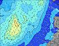 | 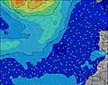 | 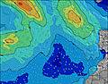 | 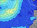 | ||||||||||||||
Wave Height (m) Direction Period (s) | NNE 7 | NNE 7 | NNE 7 | NE 6 | NNE 7 | NNE 7 | NE 7 | NE 7 | NE 7 | NNE 7 | NNE 7 | NNE 8 | NNE 7 | NNE 8 | NNE 8 | NNE 8 | NNE 8 | NNE 8 | NNE 8 | NNE 8 | NNE 7 |
Wave Graph | |||||||||||||||||||||
180 | 170 | 175 | 153 | 192 | 222 | 323 | 322 | 279 | 342 | 372 | 382 | 379 | 434 | 511 | 614 | 567 | 547 | 375 | 319 | 233 | |
Wind (km/h) | |||||||||||||||||||||
Wind State on-shore cross-onshore cross-shore cross-offshore off-shore glassy | cross-on | cross-on | cross-on | cross-on | cross-on | cross-on | cross-on | cross-on | cross-on | cross-on | cross-on | cross-on | on | on | on | on | on | on | on | on | on |
High Tide | 5:05PM2.00m | 5:32AM1.81m | 5:46PM1.89m | 6:18AM1.73m | 6:38PM1.76m | 7:17AM1.64m | 7:46PM1.63m | 8:34AM1.59m | 9:17PM1.57m | 10:04AM1.64m | 10:48PM1.62m | 11:21AM1.78m | 00:00AM1.75m | ||||||||
Low Tide | 10:48AM0.31m | 11:19PM0.27m | 11:29AM0.39m | 00:01AM0.36m | 12:18PM0.49m | 00:54AM0.47m | 1:23PM0.59m | 2:04AM0.57m | 2:51PM0.63m | 3:34AM0.60m | 4:28PM0.56m | 5:00AM0.53m | 5:46PM0.39m | ||||||||
7:24 | — | — | 7:26 | — | — | 7:26 | — | — | 7:26 | — | — | 7:26 | — | — | 7:28 | — | — | 7:28 | — | — | |
— | 8:51 | — | — | 8:50 | — | — | 8:50 | — | — | 8:49 | — | — | 8:47 | — | — | 8:46 | — | — | 8:46 | — | |
mm | — | — | — | — | — | — | — | — | — | — | — | — | — | — | — | — | — | — | — | — | — |
Temp °C | 26 | 27 | 24 | 26 | 26 | 24 | 24 | 25 | 23 | 24 | 24 | 22 | 24 | 24 | 22 | 24 | 24 | 23 | 24 | 24 | 22 |
Feels °C | 25 | 26 | 23 | 26 | 25 | 24 | 23 | 24 | 23 | 24 | 23 | 21 | 23 | 23 | 22 | 23 | 23 | 23 | 24 | 24 | 22 |
Swell 1 Height (m) Direction Period (s) | WNW 9 | N 9 | WNW 9 | N 8 | NW 8 | NW 8 | WNW 8 | SSW 13 | N 11 | NW 10 | NW 9 | NW 9 | NW 9 | NW 9 | NW 9 | NW 8 | NW 8 | S 12 | NW 8 | NW 8 | NW 7 |
8 | 26 | 9 | 12 | 11 | 10 | 6 | 17 | 21 | 4 | 3 | 3 | 3 | 3 | 3 | 3 | 3 | 3 | 3 | 2 | 2 | |
Swell 2 Height (m) Direction Period (s) | SSW 12 | WNW 9 | SSW 12 | WNW 9 | SSW 12 | S 12 | SW 13 | NW 11 | NW 10 | S 12 | S 12 | S 11 | S 11 | S 11 | S 13 | S 13 | S 12 | — | S 10 | S 12 | S 11 |
15 | 8 | 14 | 8 | 14 | 3 | 7 | 5 | 4 | 3 | 3 | 2 | 2 | 2 | 3 | 3 | 3 | — | 2 | 3 | 2 | |
Swell 3 Height (m) Direction Period (s) | S 18 | SSW 12 | S 16 | SSW 12 | S 15 | NW 10 | S 9 | N 12 | S 12 | — | — | S 15 | — | S 13 | S 11 | — | — | — | S 12 | — | N 11 |
6 | 15 | 5 | 14 | 4 | 4 | 2 | 3 | 3 | — | — | 4 | — | 3 | 2 | — | — | — | 3 | — | 3 | |
Wind waves Height (m) Direction Period (s) | NNE 7 | NNE 7 | NNE 7 | NE 6 | NNE 7 | NNE 7 | NE 7 | NE 7 | NE 7 | NNE 7 | NNE 7 | NNE 8 | NNE 7 | NNE 8 | NNE 8 | NNE 8 | NNE 8 | NNE 8 | NNE 8 | NNE 8 | NNE 7 |
180 | 170 | 175 | 153 | 192 | 222 | 323 | 322 | 279 | 342 | 372 | 382 | 379 | 434 | 511 | 614 | 567 | 547 | 375 | 319 | 233 | |
Nearest Offshore or Glassy | |||||||||||||||||||||
Distance (km) | 62 | 99 | 80 | 80 | 62 | 62 | 62 | 105 | 62 | 62 | 62 | 62 | 62 | 62 | 106 | 521 | 105 | 64 | 62 | 62 | 62 |
Best forecast wave conditions in Gran Canaria | |||||||||||||||||||||
Best forecast wave conditions in Spain (Africa) | |||||||||||||||||||||
Header Global | |||||||||||||||||||||
- Map Icons:
 Break
Break Live Wave Height (m)
 Live Wind Speed (km/h)
 Surf Rating (10 Max)
 Ocean Swells (m)
- Wind Speed (km/h)
Latest Updates


FREE! Surf-Forecast.com widget for your website
The surf report / weather widget below is available to embed on third party websites free of charge and provides a summary of our El Agujero surf forecast. Simply grab the html code snippet that we provide and paste it into your own site. You can choose your preferred language and metric/imperial units for the surf forecast feed to suit users of your site. Click here to get the code.
Information about the El Agujero Surf forecast
The above surf forecast table for El Agujero provides essential information for determining whether the surfing conditions will be good over the next 16 days. A general guide to surfing at El Agujero can be found by selecting the local surf guide option on the grey menu. Our El Agujero surf forecast is unique since it includes wave energy (power) that defines the real feel of the surf rather than just the height or the period. If you surf the same spot (El Agujero) regularly then make a mental note of the wave energy from the surf forecast table each time you go. Very soon you may start to choose your surf days based on the wave energy alone combined with our forecast of favourable offshore wind conditions. Our star ratings will help here and of course you will also find the usual wave height and period predictions on our surf forecasts as well as a full break down of the swell components under our advanced users option (to reveal that, click the little Einstein character under the tide times).
Further information to help with frequently asked questions about our surf forecast for El Agujero may be found under the help tab on the top menu and also by moving your mouse over the question marks on the surf forecast table itself. Please always bear in mind that the forecast is for near-shore open water and local factors at each surf break influence the actual breaking wave height, such as the beach / reef profile, water depths offshore and shelter.
El Agujero is 2 km (1 miles) from Galdar. If you plan a holiday in Gran Canaria, look for hotels and other accommodation in Galdar. Galdar has rooms for a wide range of budgets as well as car hire and transport links.
 Nearest