

Surf Forecasts:

Biologia (Mar del Plata) surf forecast from 1 Aug 2026:
- Best quality surf: Tuesday 4 Aug, 3AM (local time) - 3.5ft (1.0m), 10s period, SE swell with cross-offshore winds.
- Most powerful swell: Tuesday 4 Aug, 3AM (local time) - 3.5ft (1.0m), 10s period, SE swell with 200 kJ wave energy.
- Next surfable swell (1★+): Saturday 1 Aug, 9PM (local time) - 2.5ft (0.7m), 10s period with E swell.
Best Forecast Surf Conditions for Biologia (Mar del Plata) this week:
The surf forecast for Biologia (Mar del Plata) over the next 16 days: The first swell (rated 1 star or higher) is forecast to arrive on Saturday (Aug 01) at 9PM. The primary swell is predicted to be 0.7m and 10s period. The wind is predicted to be cross-offshore as the swell arrives.
The most powerful waves expected at Biologia (Mar del Plata) in the next 16 days are 1.0m 10s and forecast to arrive on Tuesday (Aug 04) at 3AM. Winds are predicted to be cross-offshore at the time the swell arrives. The largest open ocean swell (not directed at the beach) is 1.8m 8s period and expected on Friday (Aug 07) at 12AM.
| Wave Type | Time (-03) & Date | Wave Height & Period |
|---|---|---|
| Next good surf (1 star+) | 9PM (Sat 1st Aug) | 2.5ft (0.7m) 10s |
| Best Surf | 3AM (Tue 4th Aug) | 3.5ft (1.0m) 10s |
| Most Powerful | 3AM (Tue 4th Aug) | 3.5ft (1.0m) 10s |
Table - best surf conditions forecast for Biologia (Mar del Plata) over the next 16 days.
The Lowdown
Imperial
Alright, mate, Rusty here. Gotta be straight with you – the next 16 days are looking pretty grim for a paddle at Biologia (Mar del Plata). We’re staring down a long, dry spell with hardly any surf worth mentioning. The water is sitting at 51°, which is way warmer than usual for this time of year – a solid 4° anomaly – but that’s about the only good news.
The first real chance of anything comes on Tuesday afternoon, the 4th of August. We’ll see a small pulse of 3ft swell from the SE with a period of 10 seconds, pushing the combined energy up to 128 (moderate). The wind will be a light cross-offshore breeze, so the surface will be clean. But the wave comment says it’s "surfable waves but very ordinary conditions," so expectations need to be low. It’s a very consistent break, which is a plus, but the quality just isn’t there.
After that, it’s back to tiny, weak, and messy conditions until the 6th of August when a short-period, onshore mess with a 4ft SSW swell and 19 mph winds rolls in – that’s a kite-surfing setup, not a paddler’s dream. Then from the 7th of August through to the 16th, we’ve got days of flatness, with the odd tiny pulse of 0.3ft or 0.7ft, but nothing that will get you out of bed. The 15th of August does show a 0.3ft swell from the E with a very long period of 16 seconds, but it’s a whisper, not a wave.
Honestly, there’s no standout session here. It’s a blank run, and for a place that’s usually very consistent, that’s a real bummer. Keep your board waxed and hope the forecasts change. Rusty out.
Short Range ForecastMostly dry. Very mild (max 12°C on Sat morning, min 7°C on Sat night). Winds decreasing (fresh winds from the SW on Sat morning, calm by Mon night). | Days 4-6 Weather SummaryModerate rain (total 19mm), heaviest on Thu night. Very mild (max 15°C on Tue afternoon, min 9°C on Wed night). Winds increasing (calm on Wed afternoon, fresh winds from the NE by Thu night). | ||||||||||||||||||||
Saturday 1 | Sunday 2 | Monday 3 | Tuesday 4 | Wednesday 5 | Thursday 6 | Friday 7 | |||||||||||||||
AM | PM | Night | AM | PM | Night | AM | PM | Night | AM | PM | Night | AM | PM | Night | AM | PM | Night | AM | PM | Night | |
Swell Height Map | 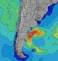 | 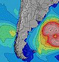 | 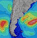 | 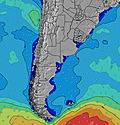 | 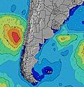 | 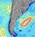 | 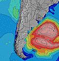 | ||||||||||||||
Wave Height (m) Direction Period (s) | E 9 | E 10 | E 10 | E 10 | E 10 | E 9 | ENE 9 | ENE 8 | ENE 8 | SE 10 | SE 10 | SE 9 | SE 9 | SE 9 | SE 9 | SE 8 | ESE 8 | E 7 | E 8 | E 8 | SSW 8 |
Wave Graph | |||||||||||||||||||||
175 | 123 | 98 | 71 | 46 | 26 | 26 | 24 | 14 | 167 | 142 | 101 | 67 | 51 | 39 | 18 | 7 | 4 | 4 | 1 | 0 | |
Wind (km/h) | |||||||||||||||||||||
Wind State on-shore cross-onshore cross-shore cross-offshore off-shore glassy | cross-off | cross-off | cross | cross-off | cross | cross-off | cross-on | glassy | cross-off | cross-off | cross | cross-off | cross-off | off | cross | cross-on | cross-on | cross | cross-off | cross | cross-off |
High Tide | 9:09AM0.95m | 9:09PM1.62m | 9:42AM0.99m | 9:48PM1.60m | 10:19AM1.05m | 10:29PM1.56m | 11:00AM1.12m | 11:14PM1.48m | 11:45AM1.20m | 00:05AM1.38m | 12:35PM1.29m | 1:04AM1.26m | 1:30PM1.38m | 2:12AM1.15m | |||||||
Low Tide | 3:11PM0.64m | 4:58AM0.38m | 3:56PM0.62m | 5:33AM0.40m | 4:42PM0.61m | 6:08AM0.43m | 5:33PM0.59m | 6:41AM0.48m | 6:31PM0.57m | 7:13AM0.55m | 7:35PM0.54m | 7:43AM0.61m | 8:49PM0.50m | ||||||||
7:50 | — | — | 7:50 | — | — | 7:48 | — | — | 7:48 | — | — | 7:47 | — | — | 7:46 | — | — | 7:45 | — | — | |
— | 6:01 | — | — | 6:02 | — | — | 6:02 | — | — | 6:04 | — | — | 6:05 | — | — | 6:06 | — | — | 6:07 | — | |
mm | — | — | — | — | — | — | — | — | — | — | — | — | — | — | — | 6 | — | 13 | — | 2 | — |
Temp °C | 12 | 10 | 8 | 9 | 10 | 10 | 12 | 12 | 12 | 14 | 15 | 13 | 12 | 15 | 13 | 9 | 9 | 11 | 13 | 13 | 9 |
Feels °C | 6 | 5 | 5 | 5 | 7 | 6 | 11 | 11 | 12 | 12 | 13 | 10 | 8 | 13 | 12 | 7 | 6 | 7 | 13 | 8 | 2 |
Swell 1 Height (m) Direction Period (s) | E 9 | E 10 | E 10 | E 10 | E 10 | S 11 | SSE 10 | SSE 10 | SE 10 | SE 10 | SE 10 | SE 9 | SE 9 | SE 9 | SSW 5 | SE 8 | ESE 8 | SSW 8 | S 8 | S 8 | — |
175 | 123 | 98 | 71 | 46 | 242 | 310 | 260 | 239 | 167 | 142 | 101 | 67 | 51 | 12 | 18 | 7 | 123 | 46 | 60 | — | |
Swell 2 Height (m) Direction Period (s) | S 8 | S 11 | S 6 | S 7 | S 7 | ENE 4 | ENE 9 | ENE 8 | ENE 8 | ENE 9 | ENE 8 | ENE 8 | ENE 7 | ENE 7 | SE 9 | ENE 7 | E 7 | E 7 | SSW 7 | SW 8 | — |
1 | 3 | 23 | 33 | 24 | 7 | 26 | 24 | 14 | 15 | 13 | 12 | 11 | 10 | 39 | 9 | 4 | 4 | 21 | 14 | — | |
Swell 3 Height (m) Direction Period (s) | — | — | S 10 | SSE 14 | SSE 12 | E 9 | — | — | S 10 | S 12 | S 11 | S 10 | S 12 | S 11 | ENE 7 | S 9 | — | SE 8 | E 8 | E 8 | — |
— | — | 2 | 36 | 51 | 26 | — | — | 2 | 3 | 2 | 2 | 3 | 10 | 10 | 2 | — | 3 | 4 | 1 | — | |
Wind waves Height (m) Direction Period (s) | SW 5 | SSW 5 | — | — | NE 3 | NE 4 | — | — | — | WSW 5 | — | NNE 2 | NNE 3 | — | — | SW 5 | SSW 7 | SW 8 | NW 3 | NW 3 | SSW 8 |
32 | 51 | — | — | 3 | 23 | — | — | — | 2 | — | 1 | 1 | — | — | 41 | 154 | 359 | 2 | 11 | 296 | |
Nearest Offshore or Glassy | |||||||||||||||||||||
Distance (km) | 181 | 181 | 1 | 0 | 9 | 4 | 1 | 1 | 1 | 0 | 1 | 2 | 2 | 0 | 2 | 118 | 9 | 118 | 9 | 480 | 826 |
Best forecast wave conditions in Provincia de Buenos Aires | |||||||||||||||||||||
Best forecast wave conditions in Argentina | |||||||||||||||||||||
Header Global | |||||||||||||||||||||
- Map Icons:
 Break
Break Live Wave Height (m)
 Live Wind Speed (km/h)
 Surf Rating (10 Max)
 Ocean Swells (m)
- Wind Speed (km/h)
Latest Updates


FREE! Surf-Forecast.com widget for your website
The surf report / weather widget below is available to embed on third party websites free of charge and provides a summary of our Biologia (Mar del Plata) surf forecast. Simply grab the html code snippet that we provide and paste it into your own site. You can choose your preferred language and metric/imperial units for the surf forecast feed to suit users of your site. Click here to get the code.
Information about the Biologia (Mar del Plata) Surf forecast
The above surf forecast table for Biologia (Mar del Plata) provides essential information for determining whether the surfing conditions will be good over the next 16 days. A general guide to surfing at Biologia (Mar del Plata) can be found by selecting the local surf guide option on the grey menu. Our Biologia (Mar del Plata) surf forecast is unique since it includes wave energy (power) that defines the real feel of the surf rather than just the height or the period. If you surf the same spot (Biologia (Mar del Plata)) regularly then make a mental note of the wave energy from the surf forecast table each time you go. Very soon you may start to choose your surf days based on the wave energy alone combined with our forecast of favourable offshore wind conditions. Our star ratings will help here and of course you will also find the usual wave height and period predictions on our surf forecasts as well as a full break down of the swell components under our advanced users option (to reveal that, click the little Einstein character under the tide times).
Further information to help with frequently asked questions about our surf forecast for Biologia (Mar del Plata) may be found under the help tab on the top menu and also by moving your mouse over the question marks on the surf forecast table itself. Please always bear in mind that the forecast is for near-shore open water and local factors at each surf break influence the actual breaking wave height, such as the beach / reef profile, water depths offshore and shelter.
Are you planning a holiday in Provincia de Buenos Aires? If you are looking for accommodation near Biologia (Mar del Plata), camping, hotels and holiday cottages in Provincia de Buenos Aires, consider staying in Mar del Plata which is 5 km (3 miles) away. Alternatively, find information about places to stay and car hire in Villa Gesell which is 98 km (61 miles) away
 Nearest