

Surf Forecasts:

Escollera Necochea surf forecast from 2 Aug 2026:
- Best quality surf: Sunday 2 Aug, 9PM (local time) - 4ft (1.2m), 11s period, S swell with offshore winds.
- Most powerful swell: Sunday 9 Aug, 6PM (local time) - 11ft (3.5m), 9s period, SW swell with 2,150 kJ wave energy.
- Next surfable swell (1★+): Sunday 2 Aug, 9PM (local time) - 4ft (1.2m), 11s period with S swell.
Best Forecast Surf Conditions for Escollera Necochea this week:
The surf forecast for Escollera Necochea over the next 16 days: The first swell (rated 1 star or higher) is forecast to arrive on Sunday (Aug 02) at 9PM. The primary swell is predicted to be 1.2m and 11s period. The wind is predicted to be offshore as the swell arrives.
The most powerful waves expected at Escollera Necochea in the next 16 days are 3.5m 9s and forecast to arrive on Sunday (Aug 09) at 6PM. Winds are predicted to be cross-shore at the time the swell arrives. The largest open ocean swell (not directed at the beach) is 0.7m 5s period and expected on Sunday (Aug 02) at 9PM.
| Wave Type | Time (-03) & Date | Wave Height & Period |
|---|---|---|
| Next good surf (1 star+) | 9PM (Sun 2nd Aug) | 4ft (1.2m) 11s |
| Best Surf | 9PM (Sun 2nd Aug) | 4ft (1.2m) 11s |
| Most Powerful | 6PM (Sun 9th Aug) | 11ft (3.5m) 9s |
Table - best surf conditions forecast for Escollera Necochea over the next 16 days.
The Lowdown
G’day, Rusty here. Let’s break down what’s coming for Escollera Necochea.
We’ve got a slow start, but a couple of sessions that will fire. The water’s about 51°F, which is a touch warmer than normal for this time of year – a nice little bonus.
Sunday afternoon (2nd August) is a bit flat – just 2 feet of south swell with a 12 second period, and a moderate NNE breeze at 12 mph keeping it clean. Not much energy (172), so it’s surfable but not memorable.
The first real standout is Monday morning (3rd August). We’ve got 4 feet of swell from the SSE, with a 10 second period and a healthy energy of 382. But the magic is the wind – glassy conditions from the NW at just 3 mph. That’s as clean as it gets, mate. This break (Escollera Necochea) is a beach and reef setup, and it’s very consistent, so you’ll have waves rolling through. If you’re a solid intermediate, this is your time.
Monday afternoon stays 5 feet but a light SW cross-onshore creeps in and knocks the face around a bit. Tuesday morning (4th August) is another good one – 4 feet of SE swell, a WNW cross-offshore at 6 mph, clean lines. Energy is 236. Crowds are only “sometimes” an issue, so you’ll have space.
From Wednesday (5th August) it drops off hard. Wednesday morning is just 2 feet (73 energy), and Wednesday afternoon gets messy with a cross-on breeze. Thursday (6th) is tiny – 1 to 1 feet – not worth paddling out. Friday (7th August) pumps up to 7 to 7 feet from the SSW, but it’s a short-period wind swell (7 seconds) with a fresh 22 mph cross-onshore. That’s kite-surfing territory, not paddle surfing. The energy (406 to 489) is wasted in the chop.
Saturday (8th August) has a messy 7 feet cross-shore mess in the afternoon. Sunday (9th August) gets even bigger – 10 to 12 feet – but with fresh cross-shore chop and lumpy seas, it’s not surfable. The energy is massive (1336 to 1894) but the wind kills it.
Now, the other standout: Monday morning (10th August). A huge 15 feet of long-period groundswell (12 seconds) from the south, with a clean cross-offshore wind. Energy is a monster 6015. But that size is too big for this break unless you’re an expert. The long period (12 seconds) means it’ll break heavy and fast. Expert-only.
Through the rest of the week, it drops to 5 to 8 feet but with onshore or cross-shore winds keeping it average. Wednesday (12th August) morning is 5 feet (531 energy) with a gentle cross-shore – marginal. Thursday (13th August) has 5 feet from the SSE at an 11 second period, with a NNE offshore at 16 mph – clean but a bit bumpy.
From Saturday (15th August) to Monday (17th August), it’s tiny – under 1 foot with weak energy. Not worth the effort.
So the best session is Monday morning (3rd August) – that glassy 4 feet SSE swell with clean conditions is the winner. The long-range Monday (10th August) is huge and clean but only for experts. Everything else is small or windy.
Rusty.
Short Range ForecastMostly dry. Very mild (max 16°C on Tue afternoon, min 11°C on Sun night). Wind will be generally light. | Days 5-7 Weather SummaryModerate rain (total 19mm), heaviest on Thu night. Very mild (max 16°C on Thu morning, min 6°C on Sat morning). Winds increasing (light winds from the SW on Wed afternoon, strong winds from the SW by Thu night). | |||||||||||||||||||
Sun 2 | Monday 3 | Tuesday 4 | Wednesday 5 | Thursday 6 | Friday 7 | Saturday 8 | ||||||||||||||
PM | Night | AM | PM | Night | AM | PM | Night | AM | PM | Night | AM | PM | Night | AM | PM | Night | AM | PM | Night | |
Swell Height Map |  | 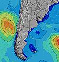 | 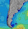 | 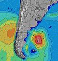 | 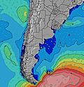 | 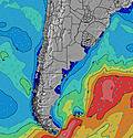 | 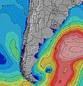 | |||||||||||||
Wave Height (m) Direction Period (s) | S 12 | SSE 10 | SSE 10 | SSE 11 | SE 11 | SE 10 | SE 10 | SE 10 | SE 9 | SE 9 | SE 9 | SE 8 | SE 8 | ESE 8 | SSW 7 | SW 7 | SSW 7 | SSE 8 | WSW 7 | SSW 7 |
Wave Graph | ||||||||||||||||||||
104 | 385 | 382 | 425 | 368 | 235 | 188 | 133 | 67 | 65 | 38 | 18 | 10 | 6 | 406 | 489 | 261 | 110 | 444 | 378 | |
Wind (km/h) | ||||||||||||||||||||
Wind State on-shore cross-onshore cross-shore cross-offshore off-shore glassy | off | off | glassy | cross-on | off | cross-off | cross-off | off | cross-off | cross-on | cross-off | off | off | cross-on | cross-on | cross-on | cross-off | cross-off | cross | cross-on |
High Tide | 9:20PM1.73m | 10:05AM1.35m | 10:03PM1.69m | 10:42AM1.41m | 10:49PM1.61m | 11:21AM1.48m | 11:39PM1.50m | 12:04PM1.55m | 00:36AM1.37m | 12:52PM1.61m | 1:40AM1.24m | 1:46PM1.67m | 2:52AM1.15m | |||||||
Low Tide | 3:48PM0.57m | 4:49AM0.10m | 4:36PM0.52m | 5:25AM0.18m | 5:25PM0.46m | 5:58AM0.28m | 6:16PM0.39m | 6:27AM0.39m | 7:10PM0.31m | 6:48AM0.50m | 8:10PM0.24m | 7:06AM0.59m | 9:17PM0.18m | |||||||
— | — | 7:54 | — | — | 7:52 | — | — | 7:52 | — | — | 7:50 | — | — | 7:50 | — | — | 7:48 | — | — | |
6:06 | — | — | 6:07 | — | — | 6:07 | — | — | 6:08 | — | — | 6:09 | — | — | 6:09 | — | — | 6:10 | — | |
mm | — | — | — | — | — | — | — | — | — | — | — | — | — | 19 | — | — | — | — | — | 4 |
Temp °C | 12 | 13 | 14 | 15 | 14 | 13 | 16 | 15 | 14 | 15 | 13 | 16 | 16 | 12 | 9 | 9 | 8 | 10 | 10 | 8 |
Feels °C | 8 | 11 | 13 | 13 | 13 | 10 | 14 | 12 | 13 | 14 | 10 | 11 | 13 | 8 | 1 | 1 | 3 | 4 | 4 | 0 |
Swell 1 Height (m) Direction Period (s) | SSW 8 | SSE 10 | SSE 10 | SSE 11 | SE 11 | SE 10 | SE 10 | SE 10 | SE 9 | SE 9 | SE 9 | SE 8 | ENE 4 | E 6 | ENE 7 | E 7 | SSW 7 | SSE 8 | SSE 8 | E 8 |
68 | 385 | 382 | 425 | 368 | 235 | 188 | 133 | 67 | 65 | 38 | 18 | 7 | 20 | 9 | 4 | 261 | 110 | 73 | 1 | |
Swell 2 Height (m) Direction Period (s) | S 12 | E 5 | ENE 6 | ENE 9 | ENE 8 | ENE 9 | ENE 8 | ENE 8 | SSW 8 | SW 5 | SW 6 | ENE 7 | SE 8 | SSW 6 | — | — | E 7 | E 7 | E 7 | E 8 |
104 | 20 | 14 | 26 | 14 | 15 | 7 | 7 | 6 | 14 | 10 | 10 | 10 | 3 | — | — | 4 | 4 | 1 | 1 | |
Swell 3 Height (m) Direction Period (s) | E 10 | ENE 9 | ENE 9 | ENE 5 | WSW 4 | WSW 4 | SW 6 | SW 5 | ENE 8 | ENE 8 | ENE 7 | SW 6 | ENE 7 | ESE 8 | — | — | ENE 7 | — | E 8 | — |
50 | 17 | 8 | 11 | 2 | 1 | 1 | 1 | 6 | 6 | 11 | 5 | 5 | 6 | — | — | 10 | — | 1 | — | |
Wind waves Height (m) Direction Period (s) | NE 3 | NNW 2 | WNW 3 | — | — | — | — | NNW 3 | W 3 | WSW 5 | — | NNE 3 | NNW 3 | W 4 | SSW 7 | SW 7 | WSW 7 | W 5 | WSW 7 | SSW 7 |
3 | 1 | 2 | — | — | — | — | 3 | 5 | 22 | — | 5 | 3 | 9 | 406 | 489 | 110 | 102 | 444 | 378 | |
Nearest Offshore or Glassy | ||||||||||||||||||||
Distance (km) | 0 | 0 | 0 | 1 | 0 | 0 | 0 | 0 | 0 | 29 | 82 | 449 | 553 | 524 | 1183 | 302 | 69 | 120 | 120 | 525 |
Best forecast wave conditions in Provincia de Buenos Aires | ||||||||||||||||||||
Best forecast wave conditions in Argentina | ||||||||||||||||||||
Header Global | ||||||||||||||||||||
- Map Icons:
 Break
Break Live Wave Height (m)
 Live Wind Speed (km/h)
 Surf Rating (10 Max)
 Ocean Swells (m)
- Wind Speed (km/h)
Latest Updates


FREE! Surf-Forecast.com widget for your website
The surf report / weather widget below is available to embed on third party websites free of charge and provides a summary of our Escollera Necochea surf forecast. Simply grab the html code snippet that we provide and paste it into your own site. You can choose your preferred language and metric/imperial units for the surf forecast feed to suit users of your site. Click here to get the code.
Information about the Escollera Necochea Surf forecast
The above surf forecast table for Escollera Necochea provides essential information for determining whether the surfing conditions will be good over the next 16 days. A general guide to surfing at Escollera Necochea can be found by selecting the local surf guide option on the grey menu. Our Escollera Necochea surf forecast is unique since it includes wave energy (power) that defines the real feel of the surf rather than just the height or the period. If you surf the same spot (Escollera Necochea) regularly then make a mental note of the wave energy from the surf forecast table each time you go. Very soon you may start to choose your surf days based on the wave energy alone combined with our forecast of favourable offshore wind conditions. Our star ratings will help here and of course you will also find the usual wave height and period predictions on our surf forecasts as well as a full break down of the swell components under our advanced users option (to reveal that, click the little Einstein character under the tide times).
Further information to help with frequently asked questions about our surf forecast for Escollera Necochea may be found under the help tab on the top menu and also by moving your mouse over the question marks on the surf forecast table itself. Please always bear in mind that the forecast is for near-shore open water and local factors at each surf break influence the actual breaking wave height, such as the beach / reef profile, water depths offshore and shelter.
Escollera Necochea is 4 km (2 miles) from the city of Quequen. If you plan a holiday in Provincia de Buenos Aires, look for hotels and other accommodation in Quequen. Quequen has rooms for a wide range of budgets as well as car hire and transport links.
 Nearest