

Surf Forecasts:

Toquay Reef surf forecast from 3 Aug 2026:
- Best quality surf: Monday 10 Aug, 4PM (local time) - 16ft (5.0m), 16s period, WSW swell with offshore winds.
- Most powerful swell: Monday 10 Aug, 4PM (local time) - 16ft (5.0m), 16s period, WSW swell with 12,645 kJ wave energy.
- Next surfable swell (1★+): Tuesday 4 Aug, 4AM (local time) - 3.5ft (1.1m), 12s period with SW swell.
Best Forecast Surf Conditions for Toquay Reef this week:
The surf forecast for Toquay Reef over the next 16 days: The first swell (rated 1 star or higher) is forecast to arrive on Tuesday (Aug 04) at 4AM. The primary swell is predicted to be 1.1m and 12s period with a secondary swell of 0.5m and 17s. The wind is predicted to be offshore as the swell arrives.
The most powerful waves expected at Toquay Reef in the next 16 days are 5.0m 16s and forecast to arrive on Monday (Aug 10) at 4PM. Winds are predicted to be offshore at the time the swell arrives. The largest open ocean swell (not directed at the beach) is 1.1m 5s period and expected on Sunday (Aug 09) at 7AM.
| Wave Type | Time (AEST) & Date | Wave Height & Period |
|---|---|---|
| Next good surf (1 star+) | 4AM (Tue 4th Aug) | 3.5ft (1.1m) 12s |
| Best Surf | 4PM (Mon 10th Aug) | 16ft (5.0m) 16s |
| Most Powerful | 4PM (Mon 10th Aug) | 16ft (5.0m) 16s |
Table - best surf conditions forecast for Toquay Reef over the next 16 days.
The Lowdown
G’day, Rusty here.
Alright, let’s have a look at the next 16 days for the Torquay Reef. It’s a consistent reef setup that loves a good SW groundswell, and we’ve got windows of clean, offshore winds to make it proper. The water temp is about average for this time of year, so no surprises there.
We kick off on Tuesday, August 4th, with a light morning session. Swell’s around 4ft from the SW, period a solid 12 seconds, and the wind is offshore from the WNW. It’s a bit marginal due to the tide, but with moderate offshore breeze, it’s clean enough for a paddle. Wave energy is moderate (476), so don’t expect cranking power.
By Wednesday, August 5th, the swell fills in a touch more. Morning sees 6ft SW at 14 seconds, with a gentle cross-offshore breeze. The energy jumps to strong (1721), and it’s clean. This is a solid intermediate session. The afternoon holds similar but with a little less size.
Thursday, August 6th, the swell drops way back to 2ft SW, but that period stretches to 16 seconds – a proper groundswell. Gentle offshore wind in the morning, clean as a whistle. It’s small and weak (213), but for a longboard or a sneaky reef wave, it’ll be fun.
Friday, August 7th, is a standout. The morning serves up 3ft SW at 16 seconds, with a light cross-offshore breeze. The comment says “very good surf conditions,” and the energy is moderate (524). Clean, lined up, and not crowded – that’s a winner.
Saturday, August 8th, still clean but wind picks up. The swell holds at 4ft SW, 16 seconds, but the wind becomes a moderate breeze from the N. It’s still rideable, but the afternoon gets a fresh breeze and drops the score.
Sunday, August 9th, is poor. The swell drops to 3ft, and a fresh 30 km/h wind from the N makes it messy. Not worth the paddle.
Now, here’s the big one. Monday, August 10th, we get a warning. The morning swell jumps to 7ft SW at 12 seconds, energy strong (2274). But the afternoon is an absolute monster – 16ft from the WSW at 16 seconds, with offshore wind. The energy is massive (15973). This is way too big for this reef break, expert-only territory, and even then it’s questionable. Kite surfers might be frothing, but for paddle surfing, it’s a stay-on-the-beach day.
Tuesday, August 11th, comes back down. Morning 6ft SW at 16 seconds, clean with a cross-offshore breeze. Moderate energy (1829). Still a good session for experienced surfers.
Wednesday, August 12th, the swell bumps up to 8ft SW at 16 seconds, strong energy (2935). Gentle offshore wind in the morning keeps it clean, but the afternoon turns cross-shore and choppy.
Thursday, August 13th, is the absolute standout of the whole forecast. Morning brings 12ft from the SSW at 16 seconds, with a gentle offshore breeze. The energy is immense (7178), and the comment says “exceptional surf conditions for expert surfers.” This is a rare, powerful, clean groundswell hitting the reef perfectly. The afternoon holds the same size with light wind. If you’re an expert, you’re calling in sick.
Friday, August 14th, the swell drops to 6ft SSW, still 15 seconds, clean in the morning. Good for experienced surfers. The afternoon gets a cross-onshore wind and gets choppy.
Saturday, August 15th, is a little gem. Small 4ft SW at 15 seconds, but the wind is glassy in the afternoon, and the morning has a slight air. Clean, fun, and the crowd will be thin.
Sunday, August 16th, similar. 4ft SW at 16 seconds, gentle offshore wind all day. Clean, consistent, and mellow.
Monday, August 17th, the wind picks up to a fresh offshore, but the swell is tiny (3ft). Not worth it.
Tuesday, August 18th, the swell is 4ft at 18 seconds – a very long period groundswell – but the wind is onshore and choppy.
Wednesday, August 19th, we finish with a glassy morning. 5ft SW at 15 seconds, glassy wind, clean. A nice way to end the window.
So, the best on offer? Friday, August 7th for a clean, fun session with moderate energy. But the absolute standout is Thursday, August 13th – that 12ft SSW groundswell with offshore wind is a once-in-a-forecast event for expert surfers.
Rusty.
Short Range ForecastLight rain (total 8mm), mostly falling on Mon night. Very mild (max 13°C on Wed afternoon, min 7°C on Mon night). Wind will be generally light. | Days 5-7 Weather SummaryModerate rain (total 13mm), heaviest on Sun morning. Very mild (max 16°C on Sat morning, min 9°C on Sun afternoon). Winds increasing (light winds from the NW on Fri afternoon, fresh winds from the N by Sat night). | ||||||||||||||||||
Tuesday 4 | Wednesday 5 | Thursday 6 | Friday 7 | Saturday 8 | Sunday 9 | ||||||||||||||
Night | AM | PM | Night | AM | PM | Night | AM | PM | Night | AM | PM | Night | AM | PM | Night | AM | PM | Night | |
Swell Height Map |  |  |  |  | 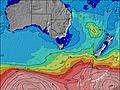 | 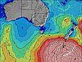 | 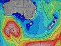 | ||||||||||||
Wave Height (m) Direction Period (s) | WSW 13 | SW 12 | SW 12 | SW 10 | SW 14 | SW 14 | SW 17 | SW 16 | SW 16 | SW 18 | SW 16 | SW 15 | SW 18 | SW 16 | SW 16 | SW 15 | SW 14 | SW 14 | SW 16 |
Wave Graph | |||||||||||||||||||
2402 | 409 | 644 | 577 | 1107 | 810 | 147 | 203 | 198 | 300 | 480 | 313 | 588 | 574 | 553 | 309 | 251 | 269 | 651 | |
Wind (km/h) | |||||||||||||||||||
Wind State on-shore cross-onshore cross-shore cross-offshore off-shore glassy | cross-off | off | cross-off | cross-off | cross-off | cross-off | cross-off | off | cross-off | cross-off | cross-off | cross-off | cross-off | cross-off | cross-off | cross-off | cross-off | cross-off | cross-off |
High Tide | 3:11AM1.69m | 3:22PM1.87m | 3:50AM1.75m | 3:48PM1.85m | 4:31AM1.80m | 4:16PM1.83m | 5:15AM1.81m | 4:48PM1.80m | 6:04AM1.79m | 5:24PM1.75m | 7:02AM1.74m | 6:09PM1.69m | |||||||
Low Tide | 9:09AM0.45m | 9:40PM0.35m | 9:45AM0.51m | 10:11PM0.26m | 10:22AM0.60m | 10:45PM0.19m | 11:02AM0.70m | 11:24PM0.14m | 11:46AM0.81m | 00:11AM0.13m | 12:38PM0.93m | 1:07AM0.16m | |||||||
— | 7:20 | — | — | 7:20 | — | — | 7:18 | — | — | 7:18 | — | — | 7:16 | — | — | 7:16 | — | — | |
— | — | 5:36 | — | — | 5:37 | — | — | 5:37 | — | — | 5:37 | — | — | 5:38 | — | — | 5:39 | — | |
mm | 2 | 2 | 2 | 1 | — | 1 | — | — | — | — | — | — | — | — | 2 | 5 | 4 | 2 | 2 |
Temp °C | 9 | 11 | 12 | 10 | 12 | 13 | 11 | 12 | 12 | 11 | 12 | 13 | 12 | 16 | 13 | 13 | 12 | 11 | 10 |
Feels °C | 5 | 5 | 7 | 6 | 8 | 9 | 8 | 7 | 9 | 8 | 8 | 9 | 9 | 10 | 7 | 6 | 6 | 4 | 3 |
Swell 1 Height (m) Direction Period (s) | SW 13 | SW 12 | SW 16 | SW 10 | SSW 15 | SSW 9 | SW 13 | SW 16 | SW 16 | SW 18 | SW 16 | SW 15 | SW 18 | SW 16 | SW 16 | SW 15 | SW 14 | SW 14 | SW 16 |
352 | 409 | 119 | 229 | 455 | 121 | 106 | 203 | 198 | 300 | 480 | 313 | 588 | 574 | 553 | 309 | 251 | 269 | 651 | |
Swell 2 Height (m) Direction Period (s) | WSW 13 | SW 16 | S 16 | SW 15 | SW 20 | SW 14 | SW 17 | S 5 | SW 6 | SSW 5 | S 6 | S 7 | S 7 | S 7 | S 6 | — | — | NNE 5 | SW 20 |
120 | 67 | 5 | 54 | 98 | 167 | 147 | 5 | 9 | 24 | 26 | 32 | 24 | 8 | 3 | — | — | 2 | 251 | |
Swell 3 Height (m) Direction Period (s) | SW 17 | N 4 | — | SW 21 | SW 11 | SW 18 | SW 8 | S 16 | S 8 | SW 14 | SW 6 | SW 19 | — | — | — | — | — | NE 6 | — |
148 | 2 | — | 109 | 61 | 166 | 32 | 5 | 1 | 73 | 18 | 231 | — | — | — | — | — | 1 | — | |
Wind waves Height (m) Direction Period (s) | WSW 13 | WNW 3 | SW 12 | SW 10 | SW 14 | SW 14 | — | NW 2 | W 2 | SW 5 | — | — | — | ESE 7 | NNE 4 | NNE 4 | NNE 5 | WNW 3 | NW 3 |
2402 | 3 | 644 | 577 | 1107 | 810 | — | 1 | 1 | 56 | — | — | — | 15 | 10 | 17 | 52 | 5 | 8 | |
Nearest Offshore or Glassy | |||||||||||||||||||
Distance (km) | 1 | 4 | 16 | 1 | 1 | 1 | 0 | 0 | 1 | 0 | 0 | 0 | 0 | 14 | 34 | 167 | 519 | 232 | 359 |
Best forecast wave conditions in Torquay | |||||||||||||||||||
Best forecast wave conditions in Australia | |||||||||||||||||||
Header Global | |||||||||||||||||||
- Map Icons:
 Break
Break Live Wave Height (m)
 Live Wind Speed (km/h)
 Surf Rating (10 Max)
 Ocean Swells (m)
- Wind Speed (km/h)
Latest Updates


FREE! Surf-Forecast.com widget for your website
The surf report / weather widget below is available to embed on third party websites free of charge and provides a summary of our Toquay Reef surf forecast. Simply grab the html code snippet that we provide and paste it into your own site. You can choose your preferred language and metric/imperial units for the surf forecast feed to suit users of your site. Click here to get the code.
Information about the Toquay Reef Surf forecast
The above surf forecast table for Toquay Reef provides essential information for determining whether the surfing conditions will be good over the next 16 days. A general guide to surfing at Toquay Reef can be found by selecting the local surf guide option on the grey menu. Our Toquay Reef surf forecast is unique since it includes wave energy (power) that defines the real feel of the surf rather than just the height or the period. If you surf the same spot (Toquay Reef) regularly then make a mental note of the wave energy from the surf forecast table each time you go. Very soon you may start to choose your surf days based on the wave energy alone combined with our forecast of favourable offshore wind conditions. Our star ratings will help here and of course you will also find the usual wave height and period predictions on our surf forecasts as well as a full break down of the swell components under our advanced users option (to reveal that, click the little Einstein character under the tide times).
Further information to help with frequently asked questions about our surf forecast for Toquay Reef may be found under the help tab on the top menu and also by moving your mouse over the question marks on the surf forecast table itself. Please always bear in mind that the forecast is for near-shore open water and local factors at each surf break influence the actual breaking wave height, such as the beach / reef profile, water depths offshore and shelter.
Toquay Reef is 21 km (13 miles) from the city of Geelong. If you plan a holiday in Torquay, look for hotels and other accommodation in Geelong. Geelong has rooms for a wide range of budgets as well as car hire and transport links.
 Nearest