

Surf Forecasts:

Tip Beach surf forecast from 2 Aug 2026:
- Best quality surf: Thursday 6 Aug, 10PM (local time) - 5.5ft (1.7m), 7s period, SW swell with cross-offshore winds.
- Most powerful swell: Sunday 9 Aug, 4PM (local time) - 6.5ft (2.0m), 7s period, NE swell with 418 kJ wave energy.
- Next surfable swell (1★+): Monday 3 Aug, 10AM (local time) - 2ft (0.6m), 11s period with SE swell.
Best Forecast Surf Conditions for Tip Beach this week:
The surf forecast for Tip Beach over the next 16 days: The first swell (rated 1 star or higher) is forecast to arrive on Monday (Aug 03) at 10AM. The primary swell is predicted to be 0.6m and 11s period with a secondary swell of 0.5m and 6s. The wind is predicted to be offshore as the swell arrives.
The most powerful waves expected at Tip Beach in the next 16 days are 2.0m 7s and forecast to arrive on Sunday (Aug 09) at 4PM. Winds are predicted to be cross-shore at the time the swell arrives. The largest open ocean swell (not directed at the beach) is 1.7m 9s period and expected on Monday (Aug 10) at 10AM.
| Wave Type | Time (AEST) & Date | Wave Height & Period |
|---|---|---|
| Next good surf (1 star+) | 10AM (Mon 3rd Aug) | 2ft (0.6m) 11s |
| Best Surf | 10PM (Thu 6th Aug) | 5.5ft (1.7m) 7s |
| Most Powerful | 4PM (Sun 9th Aug) | 6.5ft (2.0m) 7s |
Table - best surf conditions forecast for Tip Beach over the next 16 days.
The Lowdown
Alright folks, Rusty here. Let’s take a look at the next couple of weeks for this stretch of coast. It’s a bit of a mixed bag, so let’s break it down day by day.
Right out of the gate, we're looking at a pretty slow start. The next few days are super weak, with only knee-high slop and not much push. The energy’s pretty dismal, with readings like 60 and 95 (weak energy) – you’re basically bobbing around out there. The wind is mostly cross-off but the swell just isn't there. A light morning breeze on Monday keeps it clean, but it's a real “check the cam and go back to bed” kind of situation. Water temp is sitting around 58.6°F, which is pretty much spot-on average for this time of year, so that’s not a worry.
Tuesday and Wednesday stay quiet, with a bit more swell mixing in from the SW, but the period is short and the energy is still weak (95 to 98). It’s clean but gutless. Thursday sees a little bump, pushing up to 4.9ft, with moderate energy starting to show (414), but the period is still short (8 seconds), so it’s likely to be a bit crumbly and weak. We're still in "ordinary" territory here.
The next few days after that are honestly poor. We’ve got a run of cross-shore winds, onshore junk, and some messy, short-period swell. Friday afternoon and the weekend look rough. The energy dips down again (71-84), and there’s even a bit of rain and a fresh breeze on Monday morning, which is not ideal. The swell does jump on Sunday afternoon to 6.6ft, but the period is a short 7 seconds and it's cross-shore, so it'll be a churny mess, more for the kitesurfers than anyone on a paddleboard.
Now, look, I’m not going to sugarcoat it: the first week and a half of this forecast window is a whole lot of nothing. We're looking at a solid stretch of maybe 8 or 9 days with no real reason to get excited. The consistency is there, but the quality is lacking.
But hold on. If you can wait, there’s a little light at the end of the tunnel. The following Monday, the 11th, has a morning window that looks like our first real standout. The swell drops back to a clean 4.3ft from the SSW, with a light offshore WNW breeze. The energy is climbing to a moderate 297, and it’s clean. This is the dawn patrol you’ve been waiting for. It’s the one day in that first week where the stars align, and Tip Beach might actually have a few fun ones.
After another couple of ordinary days, things really start to pump. The 13th and 14th see a serious pulse of swell. We're talking 7.5ft building to 9.8ft with strong to very strong energy, hitting over 2000 on the 14th. That is a lot of water moving around. The wind is favorable, cross-off and clean, but this is where I have to wave the caution flag. This swell is predicted to be too big for this break. At this size, it's only for the experts, and even then, it might be a washing machine. The period is around 9-11 seconds, so there's some good energy in it, but it might close out and be too heavy for the average surfer. This is the real standout for power, but it's not for the faint of heart.
So, to sum it up: the first ten days are a write-off for any decent waves. Be patient. The morning of the 11th is your first real chance at a clean, fun session. And then the 13th and 14th bring a big, powerful, and clean swell, but it’s likely going to be too much for the break and only for the most experienced. It's promising but I’d keep my expectations in check until we get closer.
Stay stoked.
Short Range ForecastMostly dry. Very mild (max 18°C on Mon morning, min 7°C on Tue night). Wind will be generally light. | Days 4-6 Weather SummaryMostly dry. Very mild (max 16°C on Sat morning, min 9°C on Sat night). Wind will be generally light. | ||||||||||||||||||||
Monday 3 | Tuesday 4 | Wednesday 5 | Thursday 6 | Friday 7 | Saturday 8 | Sunday 9 | |||||||||||||||
AM | PM | Night | AM | PM | Night | AM | PM | Night | AM | PM | Night | AM | PM | Night | AM | PM | Night | AM | PM | Night | |
Swell Height Map |  |  |  | 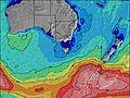 | 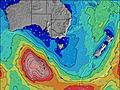 | 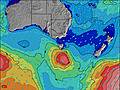 | 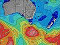 | ||||||||||||||
Wave Height (m) Direction Period (s) | SE 11 | SE 11 | SW 6 | SW 7 | SW 7 | E 14 | S 10 | S 10 | S 7 | SW 8 | SW 8 | S 8 | SW 7 | SSW 7 | S 8 | S 7 | NE 4 | NE 6 | NE 7 | NE 7 | NE 8 |
Wave Graph | |||||||||||||||||||||
75 | 41 | 41 | 64 | 77 | 15 | 17 | 31 | 58 | 275 | 177 | 165 | 61 | 138 | 130 | 53 | 32 | 103 | 65 | 418 | 77 | |
Wind (km/h) | |||||||||||||||||||||
Wind State on-shore cross-onshore cross-shore cross-offshore off-shore glassy | off | cross-off | off | cross-off | cross-off | off | cross-off | cross-off | cross-off | cross-off | cross-off | off | cross-off | cross-off | glassy | cross | cross | cross-off | cross | cross | off |
High Tide | 11:26AM1.16m | 11:22PM1.21m | 12:07PM1.20m | 00:15AM1.11m | 12:55PM1.25m | 1:19AM1.02m | 1:50PM1.29m | 2:36AM0.96m | 2:52PM1.34m | 3:59AM0.94m | 3:57PM1.41m | 5:16AM0.95m | 5:01PM1.48m | ||||||||
Low Tide | 5:19PM0.42m | 5:44AM0.29m | 6:17PM0.41m | 6:25AM0.35m | 7:23PM0.39m | 7:13AM0.41m | 8:38PM0.35m | 8:11AM0.46m | 9:54PM0.28m | 9:17AM0.49m | 11:05PM0.19m | 10:26AM0.49m | 00:08AM0.10m | ||||||||
6:58 | — | — | 6:58 | — | — | 6:56 | — | — | 6:56 | — | — | 6:54 | — | — | 6:54 | — | — | 6:52 | — | — | |
— | 5:15 | — | — | 5:15 | — | — | 5:15 | — | — | 5:16 | — | — | 5:17 | — | — | 5:19 | — | — | 5:20 | — | |
mm | — | — | — | — | — | — | — | — | — | — | — | — | — | — | — | — | — | — | — | — | 1 |
Temp °C | 18 | 18 | 11 | 13 | 13 | 9 | 13 | 12 | 12 | 14 | 13 | 11 | 15 | 14 | 11 | 16 | 15 | 14 | 16 | 17 | 14 |
Feels °C | 13 | 14 | 8 | 8 | 8 | 5 | 7 | 7 | 7 | 9 | 8 | 8 | 10 | 10 | 9 | 11 | 10 | 10 | 11 | 11 | 9 |
Swell 1 Height (m) Direction Period (s) | SE 11 | SE 11 | SW 6 | SE 13 | SSE 13 | S 9 | S 10 | S 10 | S 7 | S 9 | S 8 | S 8 | S 8 | SSE 9 | S 8 | S 7 | S 7 | S 6 | ENE 8 | NE 7 | NE 8 |
75 | 41 | 41 | 27 | 16 | 7 | 17 | 31 | 58 | 122 | 171 | 165 | 61 | 30 | 130 | 53 | 23 | 7 | 12 | 189 | 77 | |
Swell 2 Height (m) Direction Period (s) | NE 6 | NE 6 | SE 10 | NNE 6 | NE 6 | SE 12 | SE 12 | E 10 | SSE 10 | SSE 12 | E 12 | SW 7 | SSE 9 | E 8 | SW 6 | SE 8 | SE 8 | SSE 8 | S 6 | SE 13 | SE 13 |
18 | 11 | 17 | 3 | 1 | 6 | 6 | 8 | 33 | 14 | 12 | 41 | 31 | 5 | 14 | 18 | 10 | 6 | 3 | 7 | 7 | |
Swell 3 Height (m) Direction Period (s) | SE 15 | SE 14 | NE 6 | E 15 | E 15 | E 14 | E 13 | E 13 | SE 6 | E 12 | SE 12 | SE 12 | SE 11 | E 12 | ENE 7 | WSW 5 | SE 13 | SE 13 | SE 10 | E 15 | E 14 |
9 | 8 | 5 | 4 | 4 | 15 | 3 | 3 | 6 | 3 | 6 | 6 | 19 | 3 | 5 | 3 | 7 | 7 | 4 | 4 | 4 | |
Wind waves Height (m) Direction Period (s) | NW 3 | SW 5 | WSW 7 | SW 7 | SW 7 | SW 6 | WSW 4 | SW 5 | WSW 6 | SW 8 | SW 8 | WSW 7 | SW 7 | SSW 7 | — | — | NE 4 | NE 6 | NE 7 | NE 7 | WSW 7 |
2 | 4 | 170 | 64 | 77 | 42 | 54 | 59 | 115 | 275 | 177 | 229 | 55 | 138 | — | — | 32 | 103 | 65 | 418 | 158 | |
Nearest Offshore or Glassy | |||||||||||||||||||||
Distance (km) | 77 | 78 | 137 | 396 | 223 | 331 | 115 | 269 | 98 | 51 | 254 | 51 | 51 | 331 | 51 | 115 | 341 | 77 | 77 | 130 | 78 |
Best forecast wave conditions in East Coast of Victoria | |||||||||||||||||||||
Best forecast wave conditions in Australia | |||||||||||||||||||||
Header Global | |||||||||||||||||||||
- Map Icons:
 Break
Break Live Wave Height (m)
 Live Wind Speed (km/h)
 Surf Rating (10 Max)
 Ocean Swells (m)
- Wind Speed (km/h)
Latest Updates


FREE! Surf-Forecast.com widget for your website
The surf report / weather widget below is available to embed on third party websites free of charge and provides a summary of our Tip Beach surf forecast. Simply grab the html code snippet that we provide and paste it into your own site. You can choose your preferred language and metric/imperial units for the surf forecast feed to suit users of your site. Click here to get the code.
Information about the Tip Beach Surf forecast
The above surf forecast table for Tip Beach provides essential information for determining whether the surfing conditions will be good over the next 16 days. A general guide to surfing at Tip Beach can be found by selecting the local surf guide option on the grey menu. Our Tip Beach surf forecast is unique since it includes wave energy (power) that defines the real feel of the surf rather than just the height or the period. If you surf the same spot (Tip Beach) regularly then make a mental note of the wave energy from the surf forecast table each time you go. Very soon you may start to choose your surf days based on the wave energy alone combined with our forecast of favourable offshore wind conditions. Our star ratings will help here and of course you will also find the usual wave height and period predictions on our surf forecasts as well as a full break down of the swell components under our advanced users option (to reveal that, click the little Einstein character under the tide times).
Further information to help with frequently asked questions about our surf forecast for Tip Beach may be found under the help tab on the top menu and also by moving your mouse over the question marks on the surf forecast table itself. Please always bear in mind that the forecast is for near-shore open water and local factors at each surf break influence the actual breaking wave height, such as the beach / reef profile, water depths offshore and shelter.
Are you planning a holiday in East Coast of Victoria? If you are looking for accommodation near Tip Beach, camping, hotels and holiday cottages in East Coast of Victoria, consider staying in Eden which is 58 km (36 miles) away.
 Nearest