

Surf Forecasts:

Punta Cono surf forecast from 3 Aug 2026:
- Best quality surf: Friday 7 Aug, 2AM (local time) - 2ft (0.6m), 13s period, SW swell with cross-offshore winds.
- Most powerful swell: Friday 7 Aug, 8PM (local time) - 2ft (0.6m), 17s period, SW swell with 243 kJ wave energy.
- Next surfable swell (1★+): Monday 3 Aug, 8PM (local time) - 1.5ft (0.5m), 12s period with SW swell.
Best Forecast Surf Conditions for Punta Cono this week:
The surf forecast for Punta Cono over the next 16 days: The first swell (rated 1 star or higher) is forecast to arrive on Monday (Aug 03) at 8PM. The primary swell is predicted to be 0.5m and 12s period with a secondary swell of 0.5m and 9s. The wind is predicted to be cross-offshore as the swell arrives.
The most powerful waves expected at Punta Cono in the next 16 days are 0.6m 17s and forecast to arrive on Friday (Aug 07) at 8PM. Winds are predicted to be cross-offshore at the time the swell arrives. The largest open ocean swell (not directed at the beach) is 0.7m 16s period and expected on Saturday (Aug 08) at 2PM.
| Wave Type | Time (PDT) & Date | Wave Height & Period |
|---|---|---|
| Next good surf (1 star+) | 8PM (Mon 3rd Aug) | 1.5ft (0.5m) 12s |
| Best Surf | 2AM (Fri 7th Aug) | 2ft (0.6m) 13s |
| Most Powerful | 8PM (Fri 7th Aug) | 2ft (0.6m) 17s |
Table - best surf conditions forecast for Punta Cono over the next 16 days.
The Lowdown
Alright, Rusty here. Let’s have a look at what’s coming down the line for Punta Cono. I gotta be straight with you – it’s a tough stretch ahead. We’ve got a solid 16-day window, but the surf is pretty grim for most of it. The first recommendation doesn’t even pop up until Monday the 3rd of August, and even then, it’s barely a whisper.
The overall pattern is a long run of weak, westerly wind that’s just not setting up the point right. The swell direction is mostly from the southwest, which is what the spot wants to see, but the size is tiny and the wind is always on it, cross or cross-onshore, messing up the face. This isn’t a spot for paddle surfing when it’s like this; the setup looks more interesting for kite surfing than anything else.
We start on Monday morning, August 3rd, with a tiny 2 ft SW swell. The period is a long 12 seconds, which is a groundswell, but there’s just no push. The combined energy is weak (201). The wind is a light 6 mph cross-on from the WSW. It’s a marginal surf forecast, and honestly, it’s not worth getting wet for. The afternoon gets worse with a 9 mph crosswind.
This sorry pattern just repeats day after day through the first week. Tuesday, Wednesday, Thursday – all the same story. Small 2 ft to 2 ft SW swell, a long period, but always cross-on or cross winds. The energy stays moderate (184) on Thursday morning, but the wind is choppy. By Friday, August 7th, the energy bumps up to 259 in the morning, but it’s still poor surf conditions. The wind is a light 6 mph cross-on, so it’s not all bad, but the swell is just too small.
Saturday, August 8th, morning gives us a glimmer. Still a tiny 2 ft SW swell, but the period is 16 seconds – a very long groundswell. The energy is moderate (281), and the wind is a gentle 9 mph cross-shore, leaving a slight cross-chop. It’s marginal, but it’s the first time the conditions look a little less awful. The afternoon drops off to nearly nothing.
Then we hit a big gap. From Sunday, August 9th, right through to Friday, August 14th, the forecasts are all poor surf. The swell drops to 0.7 ft, then bounces between 1 ft and 2 ft, but the wind is always a problem. The energy climbs back up – 287 on the 11th, 323 on the 14th – but it’s all garbage with the wind. The long period on the 10th (20 seconds) is a tease, but it’s just too small and too choppy.
The one standout, if you can call it that, is Saturday, August 15th. The morning shows a 3 ft SW swell with a 16-second period. The energy is strong (363), and the wind is a light 9 mph cross-on. It’s not glassy, but it’s the best we’ve seen. The afternoon is bigger, but the wind picks up to 16 mph cross-shore, so it gets messy. Still, this is the pick of the run for a surfer who’s desperate. The 3 ft is small, but that long period might give it a bit of shape. The crowd profile says “sometimes,” so you might have a few locals out, but it won’t be packed.
Monday, August 17th, sees the swell start to build, but it’s a short-period 6-second windswell from the WNW. The energy is 114, but it’s all junk. The wind is cross-on. Tuesday, August 18th, morning has a 5 ft WNW swell, but again, a short period of 7 seconds and a 9 mph cross-on wind. The energy is 361, but it’s crumbly and messy. The water temp is about average for the time of year, no big anomaly.
So, bottom line: this is a lean period. The only real nod goes to Saturday morning, August 15th, at Punta Cono. It’s not firing, but it’s the best of a bad bunch. A long-period groundswell, moderate energy, and the lightest wind we see. Bring a log, keep your expectations low, and you might get a couple of fun ones. For the rest, it’s a waiting game.
Rusty.
Short Range ForecastMostly dry. Warm (max 24°C on Tue afternoon, min 18°C on Sun night). Wind will be generally light. | Days 5-7 Weather SummaryMostly dry. Warm (max 25°C on Thu morning, min 20°C on Fri night). Wind will be generally light. | ||||||||||||||||||
Monday 3 | Tuesday 4 | Wednesday 5 | Thursday 6 | Friday 7 | Saturday 8 | ||||||||||||||
Night | AM | PM | Night | AM | PM | Night | AM | PM | Night | AM | PM | Night | AM | PM | Night | AM | PM | Night | |
Swell Height Map |  |  |  |  | 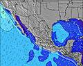 | 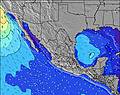 |  | ||||||||||||
Wave Height (m) Direction Period (s) | NW 8 | SW 16 | SW 16 | SW 16 | SW 15 | SW 15 | SW 14 | SW 14 | SW 14 | SW 14 | SW 13 | SW 13 | SW 13 | SW 13 | SW 17 | SW 17 | SW 16 | SW 12 | WNW 4 |
Wave Graph | |||||||||||||||||||
17 | 73 | 74 | 65 | 109 | 106 | 74 | 97 | 95 | 92 | 109 | 108 | 118 | 134 | 188 | 238 | 206 | 21 | 3 | |
Wind (km/h) | |||||||||||||||||||
Wind State on-shore cross-onshore cross-shore cross-offshore off-shore glassy | cross | cross-on | cross | cross-on | cross-on | cross | glassy | cross-on | cross | cross | cross-on | cross | cross-off | cross-on | cross | cross | cross | cross | cross |
High Tide | 11:40PM1.90m | 12:32PM2.04m | 00:28AM1.68m | 1:11PM2.08m | 1:35AM1.45m | 2:02PM2.11m | 3:30AM1.28m | 3:10PM2.13m | 6:09AM1.31m | 4:31PM2.20m | 7:29AM1.45m | 5:47PM2.32m | |||||||
Low Tide | 5:55AM0.60m | 6:46PM0.88m | 6:23AM0.76m | 8:00PM0.86m | 6:55AM0.93m | 9:37PM0.79m | 7:39AM1.10m | 11:17PM0.63m | 9:05AM1.24m | 00:32AM0.41m | 11:01AM1.28m | 1:28AM0.21m | |||||||
— | 6:00 | — | — | 6:00 | — | — | 6:01 | — | — | 6:01 | — | — | 6:01 | — | — | 6:03 | — | — | |
— | — | 7:28 | — | — | 7:27 | — | — | 7:27 | — | — | 7:25 | — | — | 7:24 | — | — | 7:23 | — | |
mm | — | — | — | — | — | — | — | — | — | — | — | — | — | — | — | — | — | — | — |
Temp °C | 20 | 21 | 22 | 21 | 23 | 24 | 21 | 24 | 24 | 23 | 25 | 25 | 23 | 24 | 25 | 22 | 24 | 24 | 21 |
Feels °C | 20 | 22 | 22 | 21 | 24 | 24 | 21 | 25 | 23 | 23 | 24 | 24 | 23 | 24 | 23 | 21 | 23 | 22 | 20 |
Swell 1 Height (m) Direction Period (s) | W 5 | WNW 9 | WNW 9 | WNW 9 | WNW 9 | WNW 9 | WNW 9 | SW 14 | SW 14 | SW 14 | SW 13 | SW 13 | SW 13 | SW 13 | SW 17 | SW 17 | SW 16 | SW 16 | SSW 15 |
17 | 62 | 48 | 47 | 48 | 47 | 33 | 97 | 95 | 92 | 109 | 108 | 106 | 134 | 188 | 238 | 206 | 258 | 146 | |
Swell 2 Height (m) Direction Period (s) | SSW 12 | SW 12 | SW 12 | SSW 13 | SW 15 | SW 15 | SW 14 | WNW 9 | WNW 9 | NW 9 | WNW 8 | SW 18 | SW 18 | SW 19 | SW 12 | SW 12 | SW 12 | SW 12 | SSW 11 |
104 | 73 | 74 | 65 | 109 | 106 | 74 | 32 | 32 | 20 | 14 | 50 | 118 | 122 | 74 | 71 | 69 | 21 | 51 | |
Swell 3 Height (m) Direction Period (s) | NW 8 | SW 16 | SW 16 | SW 16 | SSW 13 | SSW 13 | SSW 12 | SW 12 | SSW 12 | SSW 12 | SW 20 | S 11 | WNW 4 | WNW 4 | S 10 | NW 9 | NW 9 | SSW 12 | WNW 4 |
16 | 66 | 66 | 65 | 66 | 65 | 58 | 36 | 28 | 27 | 61 | 9 | 3 | 3 | 2 | 3 | 3 | 14 | 3 | |
Wind waves Height (m) Direction Period (s) | — | — | — | — | — | — | — | — | — | — | — | WNW 8 | — | — | WNW 4 | WNW 4 | WNW 4 | WNW 4 | — |
— | — | — | — | — | — | — | — | — | — | — | 13 | — | — | 4 | 5 | 3 | 4 | — | |
Nearest Offshore or Glassy | |||||||||||||||||||
Distance (km) | 200 | 484 | 367 | 243 | 367 | 367 | 117 | 367 | 367 | 187 | 367 | 367 | 187 | 367 | 367 | 367 | 367 | 367 | 318 |
Best forecast wave conditions in Baja Norte | |||||||||||||||||||
Best forecast wave conditions in Mexico | |||||||||||||||||||
Header Global | |||||||||||||||||||
- Map Icons:
 Break
Break Live Wave Height (m)
 Live Wind Speed (km/h)
 Surf Rating (10 Max)
 Ocean Swells (m)
- Wind Speed (km/h)
Latest Updates


FREE! Surf-Forecast.com widget for your website
The surf report / weather widget below is available to embed on third party websites free of charge and provides a summary of our Punta Cono surf forecast. Simply grab the html code snippet that we provide and paste it into your own site. You can choose your preferred language and metric/imperial units for the surf forecast feed to suit users of your site. Click here to get the code.
Information about the Punta Cono Surf forecast
The above surf forecast table for Punta Cono provides essential information for determining whether the surfing conditions will be good over the next 16 days. A general guide to surfing at Punta Cono can be found by selecting the local surf guide option on the grey menu. Our Punta Cono surf forecast is unique since it includes wave energy (power) that defines the real feel of the surf rather than just the height or the period. If you surf the same spot (Punta Cono) regularly then make a mental note of the wave energy from the surf forecast table each time you go. Very soon you may start to choose your surf days based on the wave energy alone combined with our forecast of favourable offshore wind conditions. Our star ratings will help here and of course you will also find the usual wave height and period predictions on our surf forecasts as well as a full break down of the swell components under our advanced users option (to reveal that, click the little Einstein character under the tide times).
Further information to help with frequently asked questions about our surf forecast for Punta Cono may be found under the help tab on the top menu and also by moving your mouse over the question marks on the surf forecast table itself. Please always bear in mind that the forecast is for near-shore open water and local factors at each surf break influence the actual breaking wave height, such as the beach / reef profile, water depths offshore and shelter.
Are you planning a holiday in Baja Norte? If you are looking for accommodation near Punta Cono, camping, hotels and holiday cottages in Baja Norte, consider staying in Abelardo L Rodriguez which is 127 km (79 miles) away.
 Nearest