

Surf Forecasts:

Minutes surf forecast from 30 Jul 2026:
- Best quality surf: Sunday 2 Aug, 12AM (local time) - 5.5ft (1.7m), 9s period, SSW swell with glassy winds.
- Most powerful swell: Sunday 2 Aug, 12AM (local time) - 5.5ft (1.7m), 9s period, SSW swell with 449 kJ wave energy.
- Next surfable swell (1★+): Friday 31 Jul, 3AM (local time) - 4ft (1.2m), 9s period with S swell.
Best Forecast Surf Conditions for Minutes this week:
The surf forecast for Minutes over the next 16 days: The first swell (rated 1 star or higher) is forecast to arrive on Friday (Jul 31) at 3AM. The primary swell is predicted to be 1.2m and 9s period with a secondary swell of 0.8m and 6s. The wind is predicted to be cross-offshore as the swell arrives.
The most powerful waves expected at Minutes in the next 16 days are 1.7m 9s and forecast to arrive on Sunday (Aug 02) at 12AM. Winds are predicted to be glassy at the time the swell arrives. The largest open ocean swell (not directed at the beach) is 0.4m 3s period and expected on Saturday (Aug 01) at 3AM.
| Wave Type | Time (ADT) & Date | Wave Height & Period |
|---|---|---|
| Next good surf (1 star+) | 3AM (Fri 31st Jul) | 4ft (1.2m) 9s |
| Best Surf | 12AM (Sun 2nd Aug) | 5.5ft (1.7m) 9s |
| Most Powerful | 12AM (Sun 2nd Aug) | 5.5ft (1.7m) 9s |
Table - best surf conditions forecast for Minutes over the next 16 days.
The Lowdown
Alright, let me tell ya what's cookin' over the next couple of weeks.
It's gonna be a bit of a slow start here, but we've got some real gems hiding further down the track. The first few days are pretty ordinary, but hang tight, because the second week is where the magic could happen.
We kick off on Thursday, July 30th, with a bit of a dud. Light rain and a 4ft easterly windswell, but it's messy with a 30 km/h easterly breeze putting a chop on everything. The combined energy is weak, just 220. Not worth paddling out for.
Come Friday, July 31st, things start to look up. The swell drops a touch but swings around to the south. We're looking at a 5ft south swell, period of 9 seconds, and the wind goes glassy, dead calm. The water is about average for this time of year. The combined energy is moderate (339). This is the first real window of clean surf. The standout here is Minutes (reef and point). It's a fairly consistent spot that's exposed to the ESE, and we've got a 5ft S swell with glassy conditions. This is your best bet for the first week.
Saturday morning, August 1st, is also looking clean with a 5ft S swell and a light WNW cross-offshore breeze. The energy is still moderate (344). It'll be a fun morning. The afternoon gets a bit messy with a cross-shore wind, and Sunday, August 2nd, goes downhill with a smaller 4ft SSW swell and a stronger cross-onshore breeze.
We then hit a long, flat spell. From Sunday afternoon, August 2nd, right through to the morning of Sunday, August 9th, the surf is just poor. We're talking tiny, weak waves (1.0ft to 3ft) with onshore winds and low energy. The combined energy values are in the double digits or low triple digits, mostly under 100. It's a real drought. There's a slight tease on the morning of Sunday, August 9th, with a 3ft SSW swell and a clean cross-offshore breeze, but the energy is still low (132) and it's not enough to get excited about.
Now, here's the real deal. The morning of Monday, August 10th, is a standout. We get a 3ft SSW groundswell with a long period of 11 seconds. The wind is glassy, and combined energy is a solid 273. This is a proper, clean swell. The long period will make it punchy for its size, best on the reef and point at Minutes, where the optimum swell direction is ESE. This is a promising one.
But the absolute best on offer is Wednesday morning, August 12th. Glassy conditions, a 4ft SSW groundswell with a period of 12 seconds, and combined energy climbing to 471. This is the pick of the bunch. It's a gorgeous, clean, moderate groundswell. The only thing to watch is that with a long period swell (12 seconds), it might break a bit straight at the beach, but on the reef and point at Minutes, it should be excellent. Crowds are possible here, so get in early.
The 13th of August (Thursday) brings a big jump in size. We're looking at a 7ft to 8ft SSW swell with a very long period of 14 seconds. The combined energy is massive, hitting 1882 and 2374. This is expert territory. It's too big for beginners, and with a light cross-onshore breeze, it might be a bit lumpy. For the experienced crew, this is a serious session, but it's not for the faint-hearted.
The 14th of August (Friday) is still big, with a 8ft S swell at 12 seconds, but the wind is cross-onshore. More size for the experts, but far from perfect.
Overall, the first week is a write-off, but the second week, especially the 10th and 12th of August, has some proper, clean, long-period groundswell on the cards. The 12th is the one to circle on the calendar.
Rusty
Short Range ForecastModerate rain (total 13mm), heaviest on Wed night. Warm (max 23°C on Sat afternoon, min 15°C on Fri night). Winds decreasing (fresh winds from the E on Thu morning, calm by Fri morning). | Days 5-7 Weather SummaryModerate rain (total 15mm), heaviest on Mon night. Warm (max 22°C on Sun morning, min 17°C on Mon night). Wind will be generally light. | ||||||||||||||||||
Thursday 30 | Friday 31 | Saturday 1 | Sunday 2 | Monday 3 | Tuesday 4 | ||||||||||||||
Night | AM | PM | Night | AM | PM | Night | AM | PM | Night | AM | PM | Night | AM | PM | Night | AM | PM | Night | |
Swell Height Map | 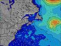 | 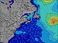 | 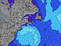 | 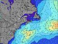 | 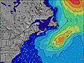 | 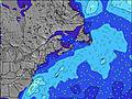 | 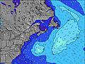 | ||||||||||||
Wave Height (m) Direction Period (s) | SSE 7 | E 5 | SSE 9 | S 9 | S 9 | S 9 | S 9 | S 9 | S 9 | SSW 9 | SSW 8 | SSW 8 | SSW 8 | SSW 8 | S 8 | S 7 | SSW 8 | SSW 8 | SSW 8 |
Wave Graph | |||||||||||||||||||
55 | 86 | 329 | 214 | 313 | 427 | 375 | 339 | 332 | 449 | 180 | 165 | 140 | 96 | 93 | 251 | 202 | 202 | 270 | |
Wind (km/h) | |||||||||||||||||||
Wind State on-shore cross-onshore cross-shore cross-offshore off-shore glassy | cross | cross | cross | cross | glassy | glassy | cross-off | cross-off | cross | glassy | cross | cross-on | cross-on | on | cross-on | cross-on | cross | cross-on | cross-off |
High Tide | 9:30AM1.52m | 9:33PM1.64m | 10:07AM1.56m | 10:11PM1.63m | 10:43AM1.59m | 10:50PM1.60m | 11:20AM1.61m | 11:31PM1.55m | 11:59AM1.61m | 00:15AM1.50m | 12:42PM1.61m | 1:05AM1.43m | |||||||
Low Tide | 3:44AM0.23m | 3:52PM0.43m | 4:18AM0.21m | 4:30PM0.39m | 4:51AM0.21m | 5:08PM0.36m | 5:24AM0.23m | 5:47PM0.34m | 6:00AM0.26m | 6:30PM0.33m | 6:39AM0.31m | 7:17PM0.33m | |||||||
— | 5:56 | — | — | 5:58 | — | — | 5:58 | — | — | 6:00 | — | — | 6:01 | — | — | 6:01 | — | — | |
8:43 | — | 8:42 | — | — | 8:40 | — | — | 8:38 | — | — | 8:37 | — | — | 8:37 | — | — | 8:35 | — | |
mm | 5 | 2 | — | 2 | — | 4 | — | — | — | — | — | — | — | — | — | 15 | — | — | — |
Temp °C | 18 | 16 | 18 | 17 | 19 | 20 | 18 | 20 | 23 | 20 | 22 | 22 | 19 | 20 | 22 | 19 | 21 | 22 | 20 |
Feels °C | 19 | 12 | 17 | 16 | 22 | 22 | 18 | 20 | 23 | 20 | 20 | 20 | 20 | 21 | 22 | 19 | 18 | 18 | 19 |
Swell 1 Height (m) Direction Period (s) | SSE 7 | SSE 7 | SSE 9 | S 9 | S 9 | S 9 | S 9 | S 9 | S 9 | SSW 9 | SSW 8 | SE 7 | SE 9 | SSW 8 | S 8 | SE 8 | SSW 8 | SSW 8 | SSW 8 |
55 | 47 | 329 | 214 | 313 | 427 | 375 | 339 | 332 | 329 | 180 | 12 | 3 | 96 | 93 | 3 | 202 | 202 | 270 | |
Swell 2 Height (m) Direction Period (s) | SSE 10 | S 9 | — | E 6 | E 6 | E 6 | ENE 5 | E 5 | E 5 | SE 9 | E 8 | E 8 | E 7 | SE 9 | SE 8 | E 9 | SE 8 | E 12 | E 11 |
9 | 83 | — | 52 | 23 | 15 | 6 | 2 | 2 | 3 | 5 | 1 | 1 | 3 | 3 | 2 | 3 | 3 | 9 | |
Swell 3 Height (m) Direction Period (s) | — | SE 10 | — | SE 10 | SE 9 | SSE 10 | E 5 | SE 9 | E 9 | E 9 | SE 9 | SE 9 | E 7 | E 7 | E 10 | — | E 9 | E 12 | — |
— | 4 | — | 4 | 3 | 9 | 5 | 3 | 2 | 1 | 3 | 3 | 1 | 1 | 2 | — | 2 | 3 | — | |
Wind waves Height (m) Direction Period (s) | E 6 | E 5 | E 6 | — | — | — | — | NW 3 | SW 3 | SSW 9 | SW 5 | SSW 8 | SSW 8 | SSE 6 | — | S 7 | — | — | NW 2 |
6 | 86 | 96 | — | — | — | — | 2 | 5 | 449 | 22 | 165 | 140 | 4 | — | 251 | — | — | 1 | |
Nearest Offshore or Glassy | |||||||||||||||||||
Distance (km) | 5 | 668 | 123 | 5 | 0 | 0 | 0 | 0 | 3 | 0 | 3 | 771 | 1363 | 944 | 711 | 594 | 3 | 2060 | 0 |
Best forecast wave conditions in Nova Scotia | |||||||||||||||||||
Best forecast wave conditions in Canada | |||||||||||||||||||
Header Global | |||||||||||||||||||
- Map Icons:
 Break
Break Live Wave Height (m)
 Live Wind Speed (km/h)
 Surf Rating (10 Max)
 Ocean Swells (m)
- Wind Speed (km/h)


FREE! Surf-Forecast.com widget for your website
The surf report / weather widget below is available to embed on third party websites free of charge and provides a summary of our Minutes surf forecast. Simply grab the html code snippet that we provide and paste it into your own site. You can choose your preferred language and metric/imperial units for the surf forecast feed to suit users of your site. Click here to get the code.
Information about the Minutes Surf forecast
The above surf forecast table for Minutes provides essential information for determining whether the surfing conditions will be good over the next 16 days. A general guide to surfing at Minutes can be found by selecting the local surf guide option on the grey menu. Our Minutes surf forecast is unique since it includes wave energy (power) that defines the real feel of the surf rather than just the height or the period. If you surf the same spot (Minutes) regularly then make a mental note of the wave energy from the surf forecast table each time you go. Very soon you may start to choose your surf days based on the wave energy alone combined with our forecast of favourable offshore wind conditions. Our star ratings will help here and of course you will also find the usual wave height and period predictions on our surf forecasts as well as a full break down of the swell components under our advanced users option (to reveal that, click the little Einstein character under the tide times).
Further information to help with frequently asked questions about our surf forecast for Minutes may be found under the help tab on the top menu and also by moving your mouse over the question marks on the surf forecast table itself. Please always bear in mind that the forecast is for near-shore open water and local factors at each surf break influence the actual breaking wave height, such as the beach / reef profile, water depths offshore and shelter.
Are you planning a holiday in Nova Scotia? If you are looking for accommodation near Minutes, camping, hotels and holiday cottages in Nova Scotia, consider staying in Cole Harbour which is 7 km (4 miles) away. Other places in and around Nova Scotia where you can find information about places to rent, and car hire include Dartmouth which is 11 km (7 miles) away, Halifax, Kings County and East Hants.
 Nearest