

Surf Forecasts:

Mellbystrand surf forecast from 26 Jul 2026:
- Most powerful swell: Monday 27 Jul, 11PM (local time) - 7ft (2.1m), 7s period, WNW swell with 407 kJ wave energy.
Best Forecast Surf Conditions for Mellbystrand this week:
The most powerful waves expected at Mellbystrand in the next 16 days are 2.1m 7s and forecast to arrive on Monday (Jul 27) at 11PM. Winds are predicted to be onshore at the time the swell arrives. The largest open ocean swell (not directed at the beach) is 0.5m 3s period and expected on Thursday (Jul 30) at 11PM.
| Wave Type | Time (CEST) & Date | Wave Height & Period |
|---|---|---|
| Next good surf (1 star+) | - | - |
| Best Surf | - | - |
| Most Powerful | 11PM (Mon 27th Jul) | 7ft (2.1m) 7s |
Table - best surf conditions forecast for Mellbystrand over the next 16 days.
The Lowdown
Alright, mate, Rusty here. Let’s have a look at what’s on the table for Mellbystrand over the next couple of weeks.
Honestly, I’ve gotta be straight with you – this forecast is a tough one to sell. We’ve got a solid 16-day window staring back at us, and the first surf worth talking about doesn’t really show up until Tuesday the 29th of July, and even then, it’s nothing to write home about. You’re looking at a long, quiet gap right through the start, with barely a ripple.
Mellbystrand is a sheltered beginner’s spot that needs a good push from the NW to work, but the winds and swell just aren’t lining up for a proper session. The water temp here is about average for the time of year, nothing wild.
Through the end of July and into early August, the swell tries to pick up a few times, but the wind is always blowing onshore or cross-onshore from the west, messing up any chance of clean faces. Tuesday the 29th sees a bit of a bump with a 6 ft swell from the WNW, but it’s accompanied by a fresh onshore breeze giving the combined energy a moderate reading (319). That’s a messy, choppy mix, not worth paddling out for. The period is short, around 5 to 7 seconds, so it’s all wind-slop, no real push.
Saturday the 1st of August has a moment of glassy conditions in the morning with no wind, but the swell is tiny at 2 ft and weak energy (16). You could probably sit on a longboard and float, but you won’t be riding anything.
Later on, towards Friday the 7th of August, the swell ticks up again to 5 ft from the WNW with moderate energy (170), but again, onshore winds spoil the party. This pattern just keeps repeating – the ocean’s got some energy, but the wind is always in the wrong place for Mellbystrand.
The only highlight, if you can call it that, is Saturday the 8th of August. You’ve got a 4 ft swell from the WNW, but for once the wind is off from the SSE, keeping things clean. Combined energy is moderate (91). The period is short at 6 seconds, so it’s not a groundswell, but with clean conditions, a beginner might find a few small, crumbly waves. Crowds are listed as "sometimes" here, so it could be fairly quiet.
Beyond that, the second week fades out into nothing – blank days with zero swell or more onshore wind. There’s no standout session here. The setup is more interesting for a kite than a paddle if the wind is strong and onshore.
Bottom line: the whole 16-day stretch is a write-off for decent surf. Keep your board waxed and wait for the next system to line up right. These quiet runs happen here – it won’t stay poor forever.
Rusty.
Short Range ForecastModerate rain (total 11mm), heaviest on Sun night. Very mild (max 19°C on Tue afternoon, min 14°C on Sun night). Winds increasing (light winds from the WNW on Sun night, fresh winds from the WNW by Mon afternoon). | Days 5-7 Weather SummaryMostly dry. Warm (max 29°C on Thu afternoon, min 15°C on Tue night). Wind will be generally light. | ||||||||||||||||||
Sunday 26 | Monday 27 | Tuesday 28 | Wednesday 29 | Thursday 30 | Friday 31 | ||||||||||||||
Night | AM | PM | Night | AM | PM | Night | AM | PM | Night | AM | PM | Night | AM | PM | Night | AM | PM | Night | |
Swell Height Map | 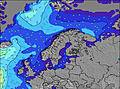 | 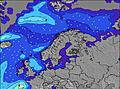 | 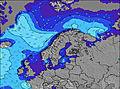 | 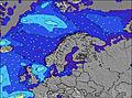 | 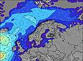 | 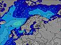 | 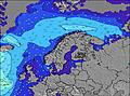 | ||||||||||||
Wave Height (m) Direction Period (s) | WSW 6 | W 5 | WNW 5 | W 4 | WNW 5 | WNW 6 | WNW 7 | WNW 7 | WNW 6 | WNW 5 | WNW 5 | WNW 4 | NW 4 | NW 4 | SSW 3 | WNW 3 | WNW 6 | WNW 6 | WNW 5 |
Wave Graph | |||||||||||||||||||
91 | 51 | 15 | 8 | 54 | 136 | 407 | 319 | 197 | 64 | 46 | 21 | 1 | 1 | 1 | 5 | 109 | 91 | 22 | |
Wind (km/h) | |||||||||||||||||||
Wind State on-shore cross-onshore cross-shore cross-offshore off-shore glassy | cross-on | on | on | on | cross-on | on | on | on | on | on | on | on | cross-off | cross-off | cross | cross-off | on | on | cross-on |
High Tide | 7:59AM0.19m | 7:57PM0.16m | 8:37AM0.20m | 8:36PM0.16m | 9:15AM0.19m | 9:16PM0.17m | 9:51AM0.19m | 9:57PM0.17m | 10:29AM0.17m | 10:39PM0.16m | 11:07AM0.15m | 11:23PM0.15m | |||||||
Low Tide | 1:21AM0.04m | 2:23PM0.07m | 2:04AM0.04m | 2:59PM0.07m | 2:46AM0.04m | 3:32PM0.06m | 3:28AM0.04m | 4:05PM0.06m | 4:11AM0.04m | 4:37PM0.05m | 4:55AM0.03m | 5:09PM0.04m | |||||||
— | 4:56 | — | — | 4:58 | — | — | 5:00 | — | — | 5:01 | — | — | 5:03 | — | — | 5:05 | — | — | |
9:32 | — | — | 9:30 | — | — | 9:29 | — | — | 9:27 | — | — | 9:24 | — | — | 9:22 | — | — | 9:21 | |
mm | 3 | — | — | 4 | 1 | 2 | 1 | — | — | — | — | — | — | — | — | — | — | — | — |
Temp °C | 18 | 16 | 18 | 16 | 17 | 17 | 16 | 16 | 19 | 18 | 17 | 22 | 21 | 25 | 29 | 27 | 20 | 21 | 20 |
Feels °C | 15 | 12 | 15 | 13 | 11 | 10 | 9 | 10 | 14 | 14 | 16 | 21 | 21 | 23 | 27 | 25 | 19 | 19 | 19 |
Swell 1 Height (m) Direction Period (s) | — | — | WNW 5 | W 8 | — | — | — | — | — | — | — | — | NW 4 | — | — | SSW 4 | — | — | — |
— | — | 15 | 1 | — | — | — | — | — | — | — | — | 1 | — | — | 3 | — | — | — | |
Swell 2 Height (m) Direction Period (s) | — | — | — | — | — | — | — | — | — | — | — | — | — | NW 4 | — | — | — | — | — |
— | — | — | — | — | — | — | — | — | — | — | — | — | 1 | — | — | — | — | — | |
Swell 3 Height (m) Direction Period (s) | — | — | — | — | — | — | — | — | — | — | — | — | — | — | — | — | — | — | — |
— | — | — | — | — | — | — | — | — | — | — | — | — | — | — | — | — | — | — | |
Wind waves Height (m) Direction Period (s) | WSW 6 | W 5 | WSW 4 | W 4 | WNW 5 | WNW 6 | WNW 7 | WNW 7 | WNW 6 | WNW 5 | WNW 5 | WNW 4 | — | — | SSW 3 | WNW 3 | WNW 6 | WNW 6 | WNW 5 |
91 | 51 | 7 | 8 | 54 | 136 | 407 | 319 | 197 | 64 | 46 | 21 | — | — | 1 | 5 | 109 | 91 | 22 | |
Nearest Offshore or Glassy | |||||||||||||||||||
Distance (km) | 483 | 335 | 340 | 1154 | 1154 | 874 | 678 | 873 | 873 | 408 | 483 | 503 | 757 | 762 | 275 | 751 | 1173 | 983 | 503 |
Best forecast wave conditions in Kattegat and Skagerrack | |||||||||||||||||||
Best forecast wave conditions in Sweden | |||||||||||||||||||
Header Global | |||||||||||||||||||
- Map Icons:
 Break
Break Live Wave Height (m)
 Live Wind Speed (km/h)
 Surf Rating (10 Max)
 Ocean Swells (m)
- Wind Speed (km/h)


FREE! Surf-Forecast.com widget for your website
The surf report / weather widget below is available to embed on third party websites free of charge and provides a summary of our Mellbystrand surf forecast. Simply grab the html code snippet that we provide and paste it into your own site. You can choose your preferred language and metric/imperial units for the surf forecast feed to suit users of your site. Click here to get the code.
Information about the Mellbystrand Surf forecast
The above surf forecast table for Mellbystrand provides essential information for determining whether the surfing conditions will be good over the next 16 days. A general guide to surfing at Mellbystrand can be found by selecting the local surf guide option on the grey menu. Our Mellbystrand surf forecast is unique since it includes wave energy (power) that defines the real feel of the surf rather than just the height or the period. If you surf the same spot (Mellbystrand) regularly then make a mental note of the wave energy from the surf forecast table each time you go. Very soon you may start to choose your surf days based on the wave energy alone combined with our forecast of favourable offshore wind conditions. Our star ratings will help here and of course you will also find the usual wave height and period predictions on our surf forecasts as well as a full break down of the swell components under our advanced users option (to reveal that, click the little Einstein character under the tide times).
Further information to help with frequently asked questions about our surf forecast for Mellbystrand may be found under the help tab on the top menu and also by moving your mouse over the question marks on the surf forecast table itself. Please always bear in mind that the forecast is for near-shore open water and local factors at each surf break influence the actual breaking wave height, such as the beach / reef profile, water depths offshore and shelter.
Mellbystrand is 10 km (6 miles) from Halmstad. If you plan a holiday in Kattegat and Skagerrack, look for hotels and other accommodation in Halmstad. Halmstad has rooms for a wide range of budgets as well as car hire and transport links.
 Nearest