

Surf Forecasts:

Margaret River Mouth surf forecast from 1 Aug 2026:
- Best quality surf: Saturday 1 Aug, 8PM (local time) - 7.5ft (2.3m), 15s period, SW swell with cross-offshore winds.
- Most powerful swell: Saturday 8 Aug, 2PM (local time) - 11ft (3.5m), 14s period, WSW swell with 4,754 kJ wave energy.
- Next surfable swell (1★+): Saturday 1 Aug, 8PM (local time) - 7.5ft (2.3m), 15s period with SW swell.
Best Forecast Surf Conditions for Margaret River Mouth this week:
The surf forecast for Margaret River Mouth over the next 16 days: The first swell (rated 1 star or higher) is forecast to arrive on Saturday (Aug 01) at 8PM. The primary swell is predicted to be 2.3m and 15s period. The wind is predicted to be cross-offshore as the swell arrives.
The most powerful waves expected at Margaret River Mouth in the next 16 days are 3.5m 14s and forecast to arrive on Saturday (Aug 08) at 2PM. Winds are predicted to be cross-onshore at the time the swell arrives. The largest open ocean swell (not directed at the beach) is 1.2m 7s period and expected on Thursday (Aug 06) at 5PM.
| Wave Type | Time (AWST) & Date | Wave Height & Period |
|---|---|---|
| Next good surf (1 star+) | 8PM (Sat 1st Aug) | 7.5ft (2.3m) 15s |
| Best Surf | 8PM (Sat 1st Aug) | 7.5ft (2.3m) 15s |
| Most Powerful | 2PM (Sat 8th Aug) | 11ft (3.5m) 14s |
Table - best surf conditions forecast for Margaret River Mouth over the next 16 days.
The Lowdown
Alright folks, it’s Rusty here. Let’s have a look at what’s cookin' for the Margaret River Mouth over the next couple of weeks.
Right off the bat, we’ve got a bit of a flat spell, so don’t get your hopes up for the first couple of days. The real juice starts to arrive on Sunday the 2nd. The standout window is going to be Sunday afternoon, with a clean, 5ft swell from the SW and a light NNE breeze making for some really nice, clean conditions. The water is a touch warmer than normal at 67°F, which is a nice little bonus for this time of year.
After that, it gets a bit wild. We’ve got some serious size coming in around the 8th and 9th of August, with swell heights hitting 13ft to 15ft. That’s big, powerful stuff, but the wind is going to be a mess – strong onshore and cross-onshore, making it a real battle. The combined wave energy is massive (9605 on the 9th morning), but it’s for experts only, and honestly, it looks more like a kite-surfing day than a clean paddle session.
The next real highlight looks like Tuesday the 11th afternoon. The wind swings around to a light SSE, giving us a clean cross-off breeze, and the swell is a solid 7ft from the SW with a nice long 16-second period. The combined energy is strong (2201), and conditions are described as “excellent for experienced surfers.” That’s a big call from the data, and it feels like a proper session.
Then we get another little window on Wednesday the 12th morning and Thursday the 13th afternoon. The 13th afternoon looks particularly sweet: 6ft SW swell, 17-second period, light NNE winds, and clean conditions. That’s a classic groundswell that will be running nicely down the river mouth.
The second week gets a bit more up and down. There’s a big spike again on the 16th with 10ft+ swell, but the wind is fresh and cross-shore, making it lumpy. The better bet that weekend is the Sunday afternoon with a southerly wind cleaning up an 8ft WSW swell.
Overall, if you’re picking your moments, the afternoons of the 11th and 13th are the best on offer. The surf is solid, the wind is right, and the quality is there. Just be aware that the long-period swells (15-17 seconds) can make the river mouth a bit straight, but when it’s clean, it’s a gem.
Rusty.
Short Range ForecastModerate rain (total 10mm), heaviest on Mon night. Very mild (max 19°C on Mon afternoon, min 10°C on Sat night). Winds increasing (light winds from the ESE on Sat night, strong winds from the NW by Mon night). | Days 4-6 Weather SummaryHeavy rain (total 28mm), heaviest during Thu night. Very mild (max 17°C on Wed afternoon, min 12°C on Thu night). Winds increasing (light winds from the WNW on Wed morning, strong winds from the WSW by Thu night). | ||||||||||||||||||||
Saturday 1 | Sunday 2 | Monday 3 | Tuesday 4 | Wednesday 5 | Thursday 6 | Friday 7 | |||||||||||||||
AM | PM | Night | AM | PM | Night | AM | PM | Night | AM | PM | Night | AM | PM | Night | AM | PM | Night | AM | PM | Night | |
Swell Height Map |  |  |  | 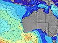 | 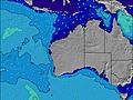 | 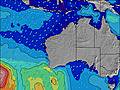 | 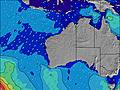 | ||||||||||||||
Wave Height (m) Direction Period (s) | SW 14 | SW 15 | SW 14 | SW 13 | SW 13 | SW 14 | SW 15 | SW 16 | SW 15 | WSW 17 | WSW 16 | WSW 16 | SW 16 | WSW 16 | WSW 16 | WSW 16 | SW 16 | WSW 16 | WSW 14 | WSW 14 | W 14 |
Wave Graph | |||||||||||||||||||||
1712 | 2814 | 1641 | 984 | 732 | 659 | 365 | 416 | 543 | 2434 | 2077 | 1257 | 3158 | 2986 | 3085 | 2162 | 1672 | 4004 | 2277 | 2122 | 3408 | |
Wind (km/h) | |||||||||||||||||||||
Wind State on-shore cross-onshore cross-shore cross-offshore off-shore glassy | cross | cross | cross-off | cross-off | cross-off | cross-off | cross-off | cross | on | on | on | on | cross-on | on | cross-on | cross-on | cross-on | cross-on | on | on | on |
High Tide | 10:36AM0.65m | 1:41AM0.36m | 10:52AM0.58m | 1:28AM0.42m | 10:56AM0.49m | 1:44AM0.48m | 10:08AM0.41m | 2:25AM0.55m | 3:31AM0.61m | 4:48AM0.68m | |||||||||||
Low Tide | 6:37PM0.21m | 3:50AM0.36m | 6:33PM0.25m | 5:28AM0.38m | 6:21PM0.28m | 7:38AM0.40m | 5:41PM0.29m | 3:22PM0.24m | 3:00PM0.14m | 3:21PM0.05m | |||||||||||
7:13 | — | — | 7:11 | — | — | 7:11 | — | — | 7:09 | — | — | 7:09 | — | — | 7:09 | — | — | 7:07 | — | — | |
— | 5:38 | — | — | 5:39 | — | — | 5:40 | — | — | 5:42 | — | — | 5:42 | — | — | 5:43 | — | — | 5:44 | — | |
mm | — | — | — | — | — | — | — | — | 10 | — | — | 1 | 2 | 1 | 4 | 5 | 4 | 11 | 1 | 2 | 7 |
Temp °C | 14 | 14 | 14 | 12 | 14 | 12 | 16 | 19 | 16 | 14 | 15 | 16 | 16 | 17 | 16 | 17 | 17 | 15 | 14 | 15 | 14 |
Feels °C | 7 | 9 | 10 | 7 | 11 | 9 | 11 | 13 | 8 | 8 | 9 | 9 | 13 | 14 | 14 | 11 | 9 | 9 | 6 | 6 | 4 |
Swell 1 Height (m) Direction Period (s) | SW 14 | SW 15 | SW 14 | SW 13 | SW 13 | SW 14 | SW 15 | SW 16 | SW 15 | WSW 17 | WSW 16 | WSW 16 | SW 16 | WSW 16 | WSW 16 | WSW 16 | SW 16 | — | WSW 14 | WSW 14 | — |
1712 | 2814 | 1641 | 984 | 732 | 659 | 365 | 416 | 543 | 2434 | 2077 | 1257 | 3158 | 2986 | 3085 | 2162 | 1672 | — | 2277 | 2122 | — | |
Swell 2 Height (m) Direction Period (s) | — | — | SW 15 | — | SW 16 | — | S 10 | — | WSW 20 | — | — | — | — | — | — | — | — | — | — | — | — |
— | — | 242 | — | 306 | — | 16 | — | 264 | — | — | — | — | — | — | — | — | — | — | — | — | |
Swell 3 Height (m) Direction Period (s) | — | — | — | — | — | — | — | — | — | — | — | — | — | — | — | — | — | — | — | — | — |
— | — | — | — | — | — | — | — | — | — | — | — | — | — | — | — | — | — | — | — | — | |
Wind waves Height (m) Direction Period (s) | — | — | — | — | — | — | N 5 | NNW 5 | W 7 | — | — | — | — | — | — | NNW 5 | NW 7 | WSW 16 | — | — | W 14 |
— | — | — | — | — | — | 11 | 27 | 100 | — | — | — | — | — | — | 34 | 139 | 4004 | — | — | 3408 | |
Nearest Offshore or Glassy | |||||||||||||||||||||
Distance (km) | 31 | 31 | 0 | 26 | 0 | 3 | 33 | 43 | 245 | 1116 | 194 | 194 | 12 | 194 | 214 | 214 | 214 | 356 | 2001 | 2001 | 2170 |
Best forecast wave conditions in Margaret River | |||||||||||||||||||||
Best forecast wave conditions in Australia | |||||||||||||||||||||
Header Global | |||||||||||||||||||||
- Map Icons:
 Break
Break Live Wave Height (m)
 Live Wind Speed (km/h)
 Surf Rating (10 Max)
 Ocean Swells (m)
- Wind Speed (km/h)
Latest Updates


FREE! Surf-Forecast.com widget for your website
The surf report / weather widget below is available to embed on third party websites free of charge and provides a summary of our Margaret River Mouth surf forecast. Simply grab the html code snippet that we provide and paste it into your own site. You can choose your preferred language and metric/imperial units for the surf forecast feed to suit users of your site. Click here to get the code.
Information about the Margaret River Mouth Surf forecast
The above surf forecast table for Margaret River Mouth provides essential information for determining whether the surfing conditions will be good over the next 16 days. A general guide to surfing at Margaret River Mouth can be found by selecting the local surf guide option on the grey menu. Our Margaret River Mouth surf forecast is unique since it includes wave energy (power) that defines the real feel of the surf rather than just the height or the period. If you surf the same spot (Margaret River Mouth) regularly then make a mental note of the wave energy from the surf forecast table each time you go. Very soon you may start to choose your surf days based on the wave energy alone combined with our forecast of favourable offshore wind conditions. Our star ratings will help here and of course you will also find the usual wave height and period predictions on our surf forecasts as well as a full break down of the swell components under our advanced users option (to reveal that, click the little Einstein character under the tide times).
Further information to help with frequently asked questions about our surf forecast for Margaret River Mouth may be found under the help tab on the top menu and also by moving your mouse over the question marks on the surf forecast table itself. Please always bear in mind that the forecast is for near-shore open water and local factors at each surf break influence the actual breaking wave height, such as the beach / reef profile, water depths offshore and shelter.
Margaret River Mouth is 92 km (57 miles) from the city of Bunbury. If you plan a holiday in Margaret River, look for hotels and other accommodation in Bunbury. Bunbury has rooms for a wide range of budgets as well as car hire and transport links.
 Nearest