

Surf Forecasts:

How big are the waves at Fraser Island - Maheno Wreck today (15 Jul):
- Morning surf: Morning surf (15 Jul, local time) - 1ft (0.3m), 10s period with ESE swell.
- Afternoon surf: Afternoon surf (15 Jul, local time) - 3ft (0.9m), 5s period with S swell.
- Evening surf: Evening surf (15 Jul, local time) - 6ft (1.9m), 6s period with SSE swell.
The current surf forecast for Fraser Island - Maheno Wreck at 4PM is: 0.9m 5s primary swell from a South direction and 0.3m 10s secondary swell from a East-southeast direction, 0.1m 6s secondary swell from a Northeast direction (forecast issued at 09:00am July 15). The wind direction is predicted to be cross-shore.
| Time (AEST) & Date | Wave Height | Wave Period |
|---|---|---|
| Morning (15 Jul) | 1ft (0.3m) | 10s |
| Afternoon (15 Jul) | 3ft (0.9m) | 5s |
| Evening (15 Jul) | 6ft (1.9m) | 6s |
Table - waves today at Fraser Island - Maheno Wreck. (Swell directed towards the surf break)
Short Range ForecastHeavy rain (total 38mm), heaviest during Wed night. Very mild (max 19°C on Thu night, min 16°C on Wed morning). Winds increasing (light winds from the SSW on Wed morning, strong winds from the SSE by Wed night). | ||||||||||||||||||||||||
Wednesday 15 | Thursday 16 | Friday 17 | Sat 18 | |||||||||||||||||||||
7 AM | 10 AM | 1 PM | 4 PM | 7 PM | 10 PM | 1 AM | 4 AM | 7 AM | 10 AM | 1 PM | 4 PM | 7 PM | 10 PM | 1 AM | 4 AM | 7 AM | 10 AM | 1 PM | 4 PM | 7 PM | 10 PM | 1 AM | 4 AM | |
Swell Height Map |  | 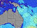 | 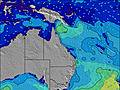 | 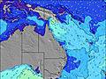 | 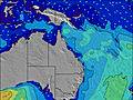 | 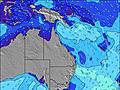 | 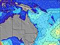 | 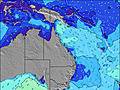 | 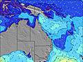 | |||||||||||||||
Wave Height (m) Direction Period (s) | ESE 10 | ESE 10 | S 5 | S 5 | SSE 6 | SSE 7 | SSE 8 | SSE 8 | SSE 8 | SSE 9 | SSE 8 | SSE 8 | SSE 8 | SSE 9 | SSE 8 | SSE 8 | SSE 9 | SSE 8 | SSE 8 | SSE 8 | SSE 8 | SSE 8 | SSE 8 | SSE 8 |
Wave Graph | ||||||||||||||||||||||||
19 | 19 | 20 | 34 | 130 | 395 | 689 | 1186 | 1446 | 1549 | 1252 | 1094 | 1094 | 953 | 800 | 550 | 512 | 453 | 432 | 533 | 525 | 645 | 680 | 1000 | |
Wind (km/h) | ||||||||||||||||||||||||
Wind State on-shore cross-onshore cross-shore cross-offshore off-shore glassy | cross-off | cross-off | cross | cross | cross | cross | cross-on | cross-on | cross | cross | cross | cross | cross | cross | cross-on | cross-on | cross-on | cross-on | cross-on | cross | cross | cross | cross | cross |
High Tide | 8:51AM2.39m | 9:25PM3.27m | 9:42AM2.42m | 10:11PM3.19m | 10:32AM2.40m | 10:55PM3.02m | ||||||||||||||||||
Low Tide | 2:47PM-0.04m | 3:48AM0.20m | 3:34PM0.04m | 4:33AM0.21m | 4:22PM0.20m | |||||||||||||||||||
6:31 | — | — | — | — | — | — | 6:31 | — | — | — | — | — | — | — | 6:31 | — | — | — | — | — | — | — | 6:31 | |
— | — | — | 5:13 | — | — | — | — | — | — | — | 5:14 | — | — | — | — | — | — | — | 5:14 | — | — | — | 5:15 | |
mm | — | — | — | — | — | 1 | 5 | 8 | 4 | 2 | 1 | 1 | 1 | 3 | 2 | 1 | 1 | 1 | 2 | 1 | 1 | 1 | 1 | — |
Temp °C | 15 | 16 | 17 | 17 | 17 | 17 | 16 | 16 | 17 | 17 | 18 | 17 | 17 | 17 | 18 | 18 | 19 | 18 | 19 | 18 | 19 | 18 | 18 | 18 |
Feels °C | 10 | 11 | 12 | 13 | 11 | 10 | 9 | 9 | 9 | 11 | 11 | 10 | 10 | 13 | 14 | 14 | 15 | 13 | 14 | 13 | 14 | 12 | 12 | 11 |
Swell 1 Height (m) Direction Period (s) | ESE 10 | ESE 10 | ESE 10 | ESE 10 | ESE 9 | NE 8 | NE 8 | ENE 8 | NE 8 | NE 8 | ENE 8 | NE 8 | NE 8 | ENE 8 | ENE 8 | SSE 8 | ENE 7 | ENE 7 | ENE 6 | ENE 6 | E 6 | NE 8 | NE 8 | E 22 |
19 | 19 | 18 | 18 | 17 | 3 | 3 | 7 | 17 | 17 | 25 | 31 | 31 | 40 | 37 | 550 | 32 | 31 | 51 | 64 | 64 | 15 | 11 | 9 | |
Swell 2 Height (m) Direction Period (s) | NE 5 | NE 6 | NE 6 | NE 6 | NE 6 | NE 8 | E 9 | — | — | — | — | ESE 10 | ESE 10 | — | ENE 7 | ENE 7 | E 8 | — | E 13 | — | — | S 19 | — | — |
1 | 1 | 1 | 1 | 1 | 3 | 1 | — | — | — | — | 10 | 9 | — | 37 | 37 | 1 | — | 3 | — | — | 7 | — | — | |
Swell 3 Height (m) Direction Period (s) | SE 7 | NE 8 | NE 8 | NE 8 | NE 8 | E 9 | — | — | — | — | — | — | — | — | ESE 9 | E 6 | — | — | — | — | — | — | — | — |
2 | 3 | 3 | 3 | 3 | 2 | — | — | — | — | — | — | — | — | 8 | 3 | — | — | — | — | — | — | — | — | |
Wind waves Height (m) Direction Period (s) | S 4 | S 4 | S 5 | S 5 | SSE 6 | SSE 7 | SSE 8 | SSE 8 | SSE 8 | SSE 9 | SSE 8 | SSE 8 | SSE 8 | SSE 9 | SSE 8 | — | SSE 9 | SSE 8 | SSE 8 | SSE 8 | SSE 8 | SSE 8 | SSE 8 | SSE 8 |
16 | 19 | 20 | 34 | 130 | 395 | 689 | 1186 | 1446 | 1549 | 1252 | 1094 | 1094 | 953 | 800 | — | 512 | 453 | 432 | 533 | 525 | 645 | 680 | 1000 | |
Nearest Offshore or Glassy | ||||||||||||||||||||||||
Distance (km) | 599 | 585 | 711 | 367 | 321 | 585 | 321 | 321 | 599 | 599 | 789 | 1151 | 326 | 126 | 126 | 126 | 126 | 711 | 711 | 865 | 645 | 687 | 321 | 599 |
Best forecast wave conditions in Queensland North Coast | ||||||||||||||||||||||||
Best forecast wave conditions in Australia | ||||||||||||||||||||||||
Header Global | ||||||||||||||||||||||||
- Map Icons:
 Break
Break Live Wave Height (m)
 Live Wind Speed (km/h)
 Surf Rating (10 Max)
 Ocean Swells (m)
- Wind Speed (km/h)


FREE! Surf-Forecast.com widget for your website
The surf report / weather widget below is available to embed on third party websites free of charge and provides a summary of our Fraser Island - Maheno Wreck surf forecast. Simply grab the html code snippet that we provide and paste it into your own site. You can choose your preferred language and metric/imperial units for the surf forecast feed to suit users of your site. Click here to get the code.
 Nearest