

Surf Forecasts:

Le Goulet surf forecast from 26 Jul 2026:
- Best quality surf: Monday 27 Jul, 10AM (local time) - 4.5ft (1.3m), 16s period, SW swell with glassy winds.
- Most powerful swell: Monday 27 Jul, 1PM (local time) - 5ft (1.5m), 16s period, SW swell with 1,109 kJ wave energy.
- Next surfable swell (1★+): Monday 27 Jul, 4AM (local time) - 3ft (0.9m), 18s period with SW swell.
Best Forecast Surf Conditions for Le Goulet this week:
The surf forecast for Le Goulet over the next 16 days: The first swell (rated 1 star or higher) is forecast to arrive on Monday (Jul 27) at 4AM. The primary swell is predicted to be 0.9m and 18s period. The wind is predicted to be cross-offshore as the swell arrives.
The most powerful waves expected at Le Goulet in the next 16 days are 1.5m 16s and forecast to arrive on Monday (Jul 27) at 1PM. Winds are predicted to be glassy at the time the swell arrives. The largest open ocean swell (not directed at the beach) is 2.1m 9s period and expected on Sunday (Aug 02) at 7PM.
| Wave Type | Time (+04) & Date | Wave Height & Period |
|---|---|---|
| Next good surf (1 star+) | 4AM (Mon 27th Jul) | 3ft (0.9m) 18s |
| Best Surf | 10AM (Mon 27th Jul) | 4.5ft (1.3m) 16s |
| Most Powerful | 1PM (Mon 27th Jul) | 5ft (1.5m) 16s |
Table - best surf conditions forecast for Le Goulet over the next 16 days.
The Lowdown
Alright, let’s break it down. We’ve got a solid pulse rolling into Le Goulet (reef) starting Monday, July 27th. The wait is over, and it’s a real treat. Monday morning and afternoon are glassy, with a clean 4ft to 3ft southwest groundswell, period hanging around 16 seconds. That’s a long-period pulse, perfect for a reef setup like this – the waves will have shape, power, and nice long lulls between sets so you can paddle out without a fight. Combined energy is sitting at 943 and 953, which is moderate to strong, and the water temp is about average for the time of year, no real anomaly to speak of. It’s just clean, good surf. The wind is dead calm, glass, so expect no bumps. Crowds are possible here, but if you get in early Monday morning, it’ll be all yours. This is the standout of the whole run.
Tuesday morning the 28th still holds some promise with 4ft from the southwest, period 14 seconds, and cross-off wind from the east at 12 mph. The wave quality takes a step back – it’s clean but not as crisp, and the combined energy drops to 735. Afternoon drops to 3ft. Wednesday and Thursday see the swell holding around 4ft to 3ft, but the east wind picks up to 16 mph, and the energy fades into the 400s. It’s still surfable, but it’s not the glassy perfection of Monday.
By Friday the 31st, the swell drops and the wind stays cross-off. The energy is down around 470. Saturday and Sunday (August 1st and 2nd) get into fresh breeze territory, 19–22 mph cross-off, with swell barely 3ft. The combined energy is still in the 400–500 range, but the wind is making it rough. For the next week, from Monday, August 3rd through to the 11th, the surf is mostly poor. The swell fades off to 1ft–3ft, and while the wind turns offshore from the southeast on the 9th and 10th, the swell is just too weak to get excited about. Energy dips into the 100s and low 200s for days. There’s a brief uptick to 3ft on the 10th with offshore wind, but with only 269 energy, it’s marginal. The 11th of August sees a strong offshore at 25 mph and 3ft from the southwest, but the energy is only 360, and the wind is so strong it’ll be hard to paddle into.
So, the honest truth: Monday, July 27th is your day. Glassy, clean, waist-to-chest high southwest groundswell with real power. After that, it’s a slow fade into small, wind-affected waves. The second week of the outlook is a write-off for quality surf. If you’re around, you’ll be fighting for scraps. Don’t sleep on Monday.
Rusty
Short Range ForecastMostly dry. Warm (max 25°C on Wed morning, min 21°C on Sun night). Wind will be generally light. | Days 5-7 Weather SummaryMostly dry. Warm (max 24°C on Thu morning, min 22°C on Wed night). Mainly fresh winds. | ||||||||||||||||||
Monday 27 | Tuesday 28 | Wednesday 29 | Thursday 30 | Friday 31 | Saturday 1 | ||||||||||||||
Night | AM | PM | Night | AM | PM | Night | AM | PM | Night | AM | PM | Night | AM | PM | Night | AM | PM | Night | |
Swell Height Map |  | 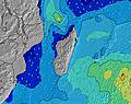 | 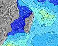 | 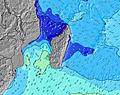 | 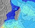 | 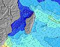 | 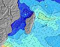 | ||||||||||||
Wave Height (m) Direction Period (s) | SW 18 | SW 16 | SW 16 | SW 15 | SW 14 | SSW 18 | SSW 16 | SW 14 | SW 14 | SSW 13 | SW 13 | SW 13 | SW 16 | SW 16 | SSW 16 | SSW 15 | SW 15 | SSW 15 | SSW 15 |
Wave Graph | |||||||||||||||||||
465 | 943 | 502 | 939 | 590 | 356 | 666 | 482 | 463 | 313 | 253 | 249 | 496 | 471 | 419 | 372 | 309 | 493 | 443 | |
Wind (km/h) | |||||||||||||||||||
Wind State on-shore cross-onshore cross-shore cross-offshore off-shore glassy | cross | glassy | glassy | off | cross-off | cross-off | cross-off | cross-off | cross-off | cross-off | cross-off | cross-off | cross-off | cross-off | cross-off | off | cross-off | cross-off | cross-off |
High Tide | 11:34PM0.56m | 12:47PM0.54m | 00:06AM0.60m | 1:09PM0.57m | 00:36AM0.64m | 1:32PM0.60m | 1:04AM0.67m | 1:54PM0.63m | 1:32AM0.68m | 2:18PM0.64m | 2:01AM0.68m | 2:43PM0.66m | 2:32AM0.67m | ||||||
Low Tide | 6:14AM0.10m | 6:16PM0.26m | 6:42AM0.07m | 6:45PM0.23m | 7:10AM0.05m | 7:12PM0.21m | 7:36AM0.05m | 7:40PM0.20m | 8:02AM0.05m | 8:08PM0.20m | 8:27AM0.07m | 8:37PM0.19m | |||||||
— | 6:41 | — | — | 6:41 | — | — | 6:41 | — | — | 6:41 | — | — | 6:39 | — | — | 6:39 | — | — | |
— | — | 5:50 | — | — | 5:51 | — | — | 5:51 | — | — | 5:52 | — | — | 5:52 | — | — | 5:52 | — | |
mm | — | — | — | — | — | — | — | — | — | — | — | — | — | — | — | — | — | — | 2 |
Temp °C | 22 | 23 | 23 | 22 | 24 | 24 | 23 | 25 | 24 | 22 | 24 | 23 | 22 | 24 | 24 | 22 | 24 | 23 | 22 |
Feels °C | 23 | 24 | 25 | 22 | 23 | 23 | 23 | 24 | 23 | 22 | 22 | 21 | 21 | 22 | 22 | 21 | 22 | 20 | 19 |
Swell 1 Height (m) Direction Period (s) | E 10 | SW 16 | E 10 | SW 15 | SW 14 | E 10 | SSW 16 | SW 14 | SW 14 | ENE 8 | ENE 8 | E 8 | E 9 | E 9 | E 9 | E 9 | E 8 | E 10 | E 10 |
228 | 943 | 233 | 939 | 590 | 194 | 666 | 482 | 463 | 123 | 207 | 277 | 351 | 258 | 264 | 220 | 201 | 262 | 266 | |
Swell 2 Height (m) Direction Period (s) | SW 18 | E 10 | SW 13 | E 10 | E 10 | SW 11 | E 10 | E 10 | ENE 7 | SSW 13 | SW 13 | SW 13 | SW 16 | SW 16 | SSW 16 | SSW 15 | SW 15 | SSW 15 | SSW 15 |
465 | 228 | 451 | 192 | 194 | 153 | 208 | 245 | 62 | 313 | 253 | 249 | 496 | 471 | 419 | 372 | 309 | 493 | 443 | |
Swell 3 Height (m) Direction Period (s) | SW 12 | N 12 | SW 16 | N 12 | SSW 19 | SSW 18 | SW 10 | ESE 11 | E 10 | E 10 | SW 18 | SW 18 | N 10 | N 10 | ESE 9 | SSW 20 | SSW 18 | N 10 | N 10 |
52 | 3 | 502 | 3 | 145 | 356 | 47 | 45 | 69 | 44 | 150 | 152 | 2 | 2 | 8 | 37 | 176 | 2 | 2 | |
Wind waves Height (m) Direction Period (s) | — | — | — | — | — | — | — | ENE 6 | — | — | — | — | E 9 | — | — | — | — | — | — |
— | — | — | — | — | — | — | 70 | — | — | — | — | 440 | — | — | — | — | — | — | |
Nearest Offshore or Glassy | |||||||||||||||||||
Distance (km) | 6 | 0 | 0 | 0 | 18 | 18 | 6 | 18 | 6 | 18 | 30 | 35 | 30 | 35 | 18 | 0 | 35 | 250 | 250 |
Best forecast wave conditions in Mauritius | |||||||||||||||||||
Best forecast wave conditions in Mauritius | |||||||||||||||||||
Header Global | |||||||||||||||||||
- Map Icons:
 Break
Break Live Wave Height (m)
 Live Wind Speed (km/h)
 Surf Rating (10 Max)
 Ocean Swells (m)
- Wind Speed (km/h)


FREE! Surf-Forecast.com widget for your website
The surf report / weather widget below is available to embed on third party websites free of charge and provides a summary of our Le Goulet surf forecast. Simply grab the html code snippet that we provide and paste it into your own site. You can choose your preferred language and metric/imperial units for the surf forecast feed to suit users of your site. Click here to get the code.
Information about the Le Goulet Surf forecast
The above surf forecast table for Le Goulet provides essential information for determining whether the surfing conditions will be good over the next 16 days. A general guide to surfing at Le Goulet can be found by selecting the local surf guide option on the grey menu. Our Le Goulet surf forecast is unique since it includes wave energy (power) that defines the real feel of the surf rather than just the height or the period. If you surf the same spot (Le Goulet) regularly then make a mental note of the wave energy from the surf forecast table each time you go. Very soon you may start to choose your surf days based on the wave energy alone combined with our forecast of favourable offshore wind conditions. Our star ratings will help here and of course you will also find the usual wave height and period predictions on our surf forecasts as well as a full break down of the swell components under our advanced users option (to reveal that, click the little Einstein character under the tide times).
Further information to help with frequently asked questions about our surf forecast for Le Goulet may be found under the help tab on the top menu and also by moving your mouse over the question marks on the surf forecast table itself. Please always bear in mind that the forecast is for near-shore open water and local factors at each surf break influence the actual breaking wave height, such as the beach / reef profile, water depths offshore and shelter.
Le Goulet is 5 km (3 miles) from Triolet. If you plan a holiday in Mauritius, look for hotels and other accommodation in Triolet. Triolet has rooms for a wide range of budgets as well as car hire and transport links.
 Nearest