

Surf Forecasts:

Port Louis surf forecast from 3 Aug 2026:
- Most powerful swell: Saturday 8 Aug, 7AM (local time) - 3ft (0.9m), 19s period, SSW swell with 584 kJ wave energy.
Best Forecast Surf Conditions for Port Louis this week:
The most powerful waves expected at Port Louis in the next 16 days are 0.9m 19s and forecast to arrive on Saturday (Aug 08) at 7AM. Winds are predicted to be cross-offshore at the time the swell arrives. The largest open ocean swell (not directed at the beach) is 0.9m 10s period and expected on Tuesday (Aug 04) at 10PM.
| Wave Type | Time (+04) & Date | Wave Height & Period |
|---|---|---|
| Next good surf (1 star+) | - | - |
| Best Surf | - | - |
| Most Powerful | 7AM (Sat 8th Aug) | 3ft (0.9m) 19s |
Table - best surf conditions forecast for Port Louis over the next 16 days.
The Lowdown
Alright, Rusty here. Let's have a look at what's on the menu for Port Louis.
First up, the water is sitting at a warm 77°, which is a touch warmer than we'd normally expect for this time of year. That's a nice little bonus. The swell window is open from the south and southwest, but the wind is a stubborn easterly, blowing cross-offshore at a solid 19 mph. That's keeping things from getting too messy, but it's a constant companion.
The forecast has a real gap to start. From Monday, the 3rd of August, all the way through the first week, the surf is just too poor to get excited about. We're looking at small, weak waves with combined energy readings barely cracking 200 to 600 (weak to moderate energy). The swell is there, but it's small, short period, and the conditions are just off. Expect a blank run for the first week. It's a tough start, but it won't last forever.
Things start to show a pulse around Tuesday, the 11th of August. The swell picks up a little, with combined energy climbing into the 600-700 range (moderate). The cross-off wind eases back to 12 mph, which is a big improvement. The waves are still a bit on the small side, but there's a hint of life. By Wednesday, the 12th, the swell pushes over 5 ft from the SSW, and the energy jumps to 1271 (strong). The wind, however, swings to the southeast, turning into a cross-shore breeze that creates a bit of a cross-chop.
The real standout, and the only one I'd really call a highlight, is looking like Wednesday, the 13th of August. The swell hits 7 ft to 8 ft from the SSW, with a period of 13 to 16 seconds. That's a proper groundswell with real energy, and the combined energy reading is a massive 3083 to 3230 (strong). The problem is, the wind is still a fresh cross-shore from the southeast at 19 mph, which is going to make it lumpy. This is expert territory. The wave size is well over 8 ft, so it's not for the faint of heart. The long period (13-16 seconds) means the waves will have plenty of power and shape, but at a beach break, they can close out a bit. The setup is better for a point or reef, but Port Louis is a sandbar. If you're an experienced surfer and don't mind a bit of chop, the 13th is the day to be in the water. The following days, from the 14th to the 17th, continue to offer solid 6 ft to 7 ft swell with strong energy, but the cross-shore wind remains a factor, keeping the conditions from being truly clean. This is a period for the dedicated, not the casual.
So, to wrap it up: endure the first week of nothing. Your best bet is the 13th of August for the biggest, most powerful swell, but be prepared for lumpy conditions and a crowd that knows what they're doing. The 14th and 15th offer a little less size but still plenty of grunt.
Rusty.
Short Range ForecastLight rain (total 4mm), mostly falling on Tue morning. Warm (max 24°C on Mon morning, min 21°C on Mon night). Mainly fresh winds. | Days 4-6 Weather SummaryLight rain (total 2mm), mostly falling on Thu afternoon. Warm (max 24°C on Thu morning, min 21°C on Thu night). Mainly fresh winds. | ||||||||||||||||||||
Monday 3 | Tuesday 4 | Wednesday 5 | Thursday 6 | Friday 7 | Saturday 8 | Sunday 9 | |||||||||||||||
AM | PM | Night | AM | PM | Night | AM | PM | Night | AM | PM | Night | AM | PM | Night | AM | PM | Night | AM | PM | Night | |
Swell Height Map | 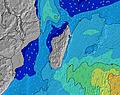 | 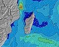 | 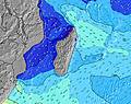 | 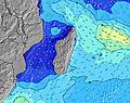 | 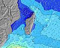 | 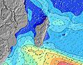 | 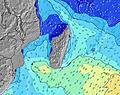 | ||||||||||||||
Wave Height (m) Direction Period (s) | S 18 | S 17 | S 15 | S 13 | S 13 | S 12 | SSW 16 | SSW 15 | SSW 14 | SW 14 | SSW 13 | SSW 13 | S 16 | SSW 12 | SSW 20 | SSW 18 | SSW 18 | SSW 16 | SW 15 | SW 14 | SW 15 |
Wave Graph | |||||||||||||||||||||
404 | 283 | 163 | 130 | 125 | 153 | 138 | 201 | 183 | 191 | 158 | 154 | 129 | 98 | 364 | 514 | 534 | 447 | 309 | 305 | 318 | |
Wind (km/h) | |||||||||||||||||||||
Wind State on-shore cross-onshore cross-shore cross-offshore off-shore glassy | cross-off | cross-off | cross-off | cross-off | cross-off | cross-off | cross-off | cross-off | cross-off | cross-off | cross-off | cross-off | cross-off | cross-off | cross-off | cross-off | cross-off | cross-off | cross-off | cross-off | cross-off |
High Tide | 3:33PM0.68m | 3:37AM0.63m | 4:07PM0.65m | 4:23AM0.56m | 4:50PM0.61m | 5:30AM0.49m | 5:54PM0.56m | 7:55AM0.44m | 7:47PM0.53m | 10:23AM0.49m | 9:41PM0.57m | 11:24AM0.56m | 10:50PM0.63m | ||||||||
Low Tide | 9:41PM0.20m | 9:48AM0.17m | 10:26PM0.22m | 10:26AM0.23m | 11:30PM0.25m | 11:19AM0.30m | 1:17AM0.26m | 1:17PM0.36m | 3:23AM0.21m | 3:41PM0.34m | 4:39AM0.13m | 4:55PM0.29m | |||||||||
6:39 | — | — | 6:37 | — | — | 6:37 | — | — | 6:37 | — | — | 6:37 | — | — | 6:35 | — | — | 6:35 | — | — | |
— | 5:52 | — | — | 5:52 | — | — | 5:53 | — | — | 5:53 | — | — | 5:53 | — | — | 5:54 | — | — | 5:54 | — | |
mm | — | — | — | 2 | — | — | 2 | — | — | — | 1 | 1 | — | — | — | — | — | — | 3 | — | — |
Temp °C | 24 | 23 | 22 | 23 | 23 | 22 | 23 | 23 | 22 | 24 | 23 | 22 | 24 | 24 | 22 | 24 | 23 | 22 | 23 | 23 | 22 |
Feels °C | 21 | 20 | 19 | 20 | 20 | 19 | 20 | 19 | 20 | 21 | 20 | 19 | 20 | 20 | 20 | 21 | 20 | 20 | 20 | 19 | 19 |
Swell 1 Height (m) Direction Period (s) | SW 14 | SW 14 | NE 10 | S 13 | ENE 10 | S 12 | NE 10 | SSW 15 | SSW 14 | SW 14 | SSW 13 | SSW 13 | ENE 9 | ENE 10 | SSW 20 | SSW 18 | SSW 18 | SSW 16 | SW 15 | SW 14 | SW 15 |
293 | 228 | 100 | 130 | 86 | 153 | 77 | 201 | 183 | 191 | 158 | 154 | 56 | 85 | 364 | 514 | 534 | 447 | 309 | 305 | 318 | |
Swell 2 Height (m) Direction Period (s) | ENE 10 | S 17 | S 15 | ENE 10 | S 13 | NE 10 | S 12 | NE 10 | NE 10 | ENE 10 | ENE 9 | ENE 8 | S 16 | SSW 12 | ENE 10 | ENE 10 | ENE 10 | SSE 6 | ENE 10 | ENE 10 | ENE 10 |
123 | 283 | 163 | 64 | 125 | 102 | 104 | 77 | 77 | 64 | 49 | 45 | 129 | 98 | 86 | 69 | 65 | 24 | 38 | 68 | 69 | |
Swell 3 Height (m) Direction Period (s) | S 18 | NE 10 | SW 13 | SW 13 | SW 13 | SW 12 | SSW 16 | SSE 8 | S 11 | SSE 6 | SSE 9 | S 18 | SW 13 | SSE 6 | SSW 13 | SSW 12 | SSE 7 | NE 10 | SSE 7 | SSE 10 | — |
404 | 96 | 109 | 61 | 59 | 37 | 138 | 28 | 21 | 14 | 28 | 25 | 79 | 24 | 147 | 96 | 25 | 49 | 16 | 56 | — | |
Wind waves Height (m) Direction Period (s) | — | SSE 7 | SSE 7 | SE 7 | SE 7 | ESE 3 | — | ESE 9 | SE 7 | ESE 3 | ESE 3 | SE 7 | SE 7 | ESE 7 | SSE 7 | SSE 7 | — | — | ESE 3 | SE 9 | SSE 10 |
— | 21 | 21 | 19 | 23 | 2 | — | 135 | 26 | 1 | 1 | 43 | 43 | 86 | 35 | 30 | — | — | 2 | 110 | 64 | |
Nearest Offshore or Glassy | |||||||||||||||||||||
Distance (km) | 246 | 246 | 30 | 218 | 246 | 30 | 42 | 246 | 30 | 218 | 246 | 218 | 246 | 246 | 30 | 218 | 246 | 30 | 218 | 246 | 30 |
Best forecast wave conditions in Mauritius | |||||||||||||||||||||
Best forecast wave conditions in Mauritius | |||||||||||||||||||||
Header Global | |||||||||||||||||||||
- Map Icons:
 Break
Break Live Wave Height (m)
 Live Wind Speed (km/h)
 Surf Rating (10 Max)
 Ocean Swells (m)
- Wind Speed (km/h)
Latest Updates


FREE! Surf-Forecast.com widget for your website
The surf report / weather widget below is available to embed on third party websites free of charge and provides a summary of our Port Louis surf forecast. Simply grab the html code snippet that we provide and paste it into your own site. You can choose your preferred language and metric/imperial units for the surf forecast feed to suit users of your site. Click here to get the code.
Information about the Port Louis Surf forecast
The above surf forecast table for Port Louis provides essential information for determining whether the surfing conditions will be good over the next 16 days. A general guide to surfing at Port Louis can be found by selecting the local surf guide option on the grey menu. Our Port Louis surf forecast is unique since it includes wave energy (power) that defines the real feel of the surf rather than just the height or the period. If you surf the same spot (Port Louis) regularly then make a mental note of the wave energy from the surf forecast table each time you go. Very soon you may start to choose your surf days based on the wave energy alone combined with our forecast of favourable offshore wind conditions. Our star ratings will help here and of course you will also find the usual wave height and period predictions on our surf forecasts as well as a full break down of the swell components under our advanced users option (to reveal that, click the little Einstein character under the tide times).
Further information to help with frequently asked questions about our surf forecast for Port Louis may be found under the help tab on the top menu and also by moving your mouse over the question marks on the surf forecast table itself. Please always bear in mind that the forecast is for near-shore open water and local factors at each surf break influence the actual breaking wave height, such as the beach / reef profile, water depths offshore and shelter.
Port Louis is 3 km (2 miles) from the city of Le Hochet. If you plan a holiday in Mauritius, look for hotels and other accommodation in Le Hochet. Le Hochet has rooms for a wide range of budgets as well as car hire and transport links.
 Nearest