

Surf Forecasts:

Jugendbad surf forecast from 2 Aug 2026:
- Best quality surf: Saturday 8 Aug, 2AM (local time) - 3ft (0.9m), 8s period, NNW swell with glassy winds.
- Most powerful swell: Thursday 6 Aug, 5PM (local time) - 6ft (1.8m), 6s period, W swell with 245 kJ wave energy.
- Next surfable swell (1★+): Saturday 8 Aug, 2AM (local time) - 3ft (0.9m), 8s period with NNW swell.
Best Forecast Surf Conditions for Jugendbad this week:
The surf forecast for Jugendbad over the next 16 days: The first swell (rated 1 star or higher) is forecast to arrive on Saturday (Aug 08) at 2AM. The primary swell is predicted to be 0.9m and 8s period. The wind is predicted to be glassy as the swell arrives.
The most powerful waves expected at Jugendbad in the next 16 days are 1.8m 6s and forecast to arrive on Thursday (Aug 06) at 5PM. Winds are predicted to be cross-shore at the time the swell arrives. The largest open ocean swell (not directed at the beach) is 1.1m 4s period and expected on Monday (Aug 03) at 8PM.
| Wave Type | Time (CEST) & Date | Wave Height & Period |
|---|---|---|
| Next good surf (1 star+) | 2AM (Sat 8th Aug) | 3ft (0.9m) 8s |
| Best Surf | 2AM (Sat 8th Aug) | 3ft (0.9m) 8s |
| Most Powerful | 5PM (Thu 6th Aug) | 6ft (1.8m) 6s |
Table - best surf conditions forecast for Jugendbad over the next 16 days.
The Lowdown
Hey team, Rusty checking in from Jugendbad. Let’s not sugarcoat it – the next two weeks are a tough beat.
Honestly, there’s not a single solid day to get frothy about in the whole 16-day window. It’s a long, empty run, which is a bummer. The water is sitting at 68°, which is a notable 4° warmer than usual for this time of year.
The first week is a total washout. Starting Sunday the 2nd, we’ve got a pathetic 2ft NW swell with a 6-second period and weak wave energy (24). The morning is glass, but there’s no push. The afternoon wind swings hard sideshore, killing any hope. Monday through Wednesday offers nothing but tiny, short-period windswell from the NW, with winds either cross or onshore ruining what little shape there is. Wednesday afternoon shows a slight bump to 4ft, but it’s a messy 5-second Westerly windswell with a strong cross-onshore wind. By Thursday afternoon, the swell gets to 6ft with energy at 246, but the wind is screaming at 28 mph from the W, turning it into a chop-infested nightmare – you’d be better off on a kite than a surfboard.
Week two doesn’t get much better. It’s a series of small, weak, and messy days. There’s a clean offshore moment on Monday the 10th, but with a 2ft swell and 5-second period, it’s barely a ripple. The rest of the week is dominated by strong cross-onshore winds and lumpy seas, with a couple days showing zero swell at all. This kind of dead run is unfortunately more normal for the area when the weather patterns aren’t playing ball.
Right at the very end, on Sunday the 16th, we get a hint of life: a 5ft swell from the W with a 6-second period and energy at 134. The afternoon goes glassy, which is a huge plus for clean conditions. It’s just surfable, but it’s a start. Then, Monday the 17th morning is the only real standout. The wind is dead calm – glassy – and the swell is 5ft from the WNW with energy hitting 200. The 6-second period means it won’t be the most powerful wave, but with zero wind, it’ll be the cleanest and most rideable of the whole stretch. It’s a long way out, so keep an eye on it.
For the beginners, that 5ft swell on the 17th is getting a bit big, so be cautious. The wait is brutal, but forecasts can shift, and that last bit of energy shows the ocean isn’t totally flat. For now, save the wax and wait for a better day.
Rusty.
Short Range ForecastMostly dry. Warm (max 26°C on Mon afternoon, min 17°C on Sun morning). Winds increasing (calm on Sun morning, fresh winds from the ENE by Mon night). | Days 4-6 Weather SummaryLight rain (total 2mm), mostly falling on Thu night. Warm (max 21°C on Wed morning, min 15°C on Fri night). Winds decreasing (strong winds from the W on Thu afternoon, calm by Fri night). | ||||||||||||||||||||
Sunday 2 | Monday 3 | Tuesday 4 | Wednesday 5 | Thursday 6 | Friday 7 | Saturday 8 | |||||||||||||||
AM | PM | Night | AM | PM | Night | AM | PM | Night | AM | PM | Night | AM | PM | Night | AM | PM | Night | AM | PM | Night | |
Swell Height Map | 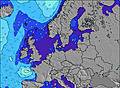 | 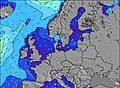 | 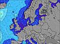 | 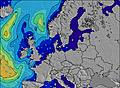 | 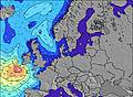 | 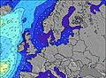 | 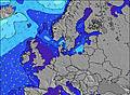 | ||||||||||||||
Wave Height (m) Direction Period (s) | NW 6 | NW 6 | NW 6 | NW 8 | ENE 4 | NNW 8 | NNW 9 | NNW 8 | NNW 8 | WSW 5 | W 5 | WSW 5 | WSW 5 | W 6 | WNW 6 | NNW 7 | NNW 7 | NNW 8 | NNW 7 | NNW 7 | N 7 |
Wave Graph | |||||||||||||||||||||
22 | 15 | 17 | 16 | 34 | 20 | 31 | 24 | 13 | 39 | 97 | 64 | 75 | 245 | 99 | 81 | 105 | 81 | 43 | 29 | 22 | |
Wind (km/h) | |||||||||||||||||||||
Wind State on-shore cross-onshore cross-shore cross-offshore off-shore glassy | glassy | cross | cross-off | cross-off | cross | cross-off | off | cross-off | cross-off | cross | cross-on | cross-off | cross | cross | cross-on | cross-on | on | glassy | cross-off | cross | cross |
High Tide | 1:53PM2.55m | 2:18AM2.28m | 2:30PM2.55m | 2:56AM2.26m | 3:10PM2.51m | 3:36AM2.22m | 3:55PM2.43m | 4:22AM2.18m | 4:46PM2.32m | 5:16AM2.13m | 5:47PM2.20m | 6:16AM2.11m | 6:56PM2.11m | ||||||||
Low Tide | 8:12PM-0.08m | 8:21AM0.02m | 8:50PM-0.06m | 9:00AM0.05m | 9:31PM0.01m | 9:43AM0.11m | 10:15PM0.12m | 10:31AM0.20m | 11:04PM0.25m | 11:27AM0.30m | 00:02AM0.39m | 12:35PM0.36m | 1:12AM0.48m | ||||||||
5:48 | — | — | 5:50 | — | — | 5:52 | — | — | 5:54 | — | — | 5:54 | — | — | 5:56 | — | — | 5:58 | — | — | |
— | — | 9:28 | — | — | 9:27 | — | — | 9:24 | — | — | 9:22 | — | — | 9:21 | — | — | 9:19 | — | — | 9:16 | |
mm | — | — | — | — | — | — | — | — | — | — | — | — | — | — | 2 | — | — | — | — | — | — |
Temp °C | 18 | 19 | 19 | 20 | 26 | 25 | 23 | 26 | 24 | 21 | 21 | 21 | 18 | 18 | 18 | 17 | 16 | 16 | 16 | 17 | 17 |
Feels °C | 17 | 14 | 14 | 15 | 21 | 20 | 23 | 27 | 21 | 19 | 16 | 17 | 14 | 10 | 11 | 14 | 13 | 14 | 15 | 12 | 12 |
Swell 1 Height (m) Direction Period (s) | NW 6 | NW 6 | NW 6 | NW 8 | NW 8 | NNW 8 | NNW 9 | NNW 8 | NNW 8 | NNW 8 | NNW 8 | NNW 7 | NNW 7 | N 7 | — | NNW 7 | NNW 7 | NNW 8 | NNW 7 | NNW 7 | N 7 |
22 | 15 | 17 | 16 | 16 | 20 | 31 | 24 | 13 | 6 | 6 | 5 | 5 | 1 | — | 81 | 105 | 81 | 43 | 29 | 22 | |
Swell 2 Height (m) Direction Period (s) | N 10 | NNW 9 | — | — | — | N 5 | ENE 4 | ENE 4 | — | W 6 | — | N 6 | — | — | — | — | W 5 | — | — | — | — |
2 | 8 | — | — | — | 2 | 4 | 1 | — | 1 | — | 1 | — | — | — | — | 1 | — | — | — | — | |
Swell 3 Height (m) Direction Period (s) | — | — | — | — | — | NNW 10 | — | — | — | — | — | — | — | — | — | — | — | — | — | — | N 7 |
— | — | — | — | — | 9 | — | — | — | — | — | — | — | — | — | — | — | — | — | — | 1 | |
Wind waves Height (m) Direction Period (s) | — | — | E 4 | E 4 | ENE 4 | ENE 4 | SE 3 | WSW 3 | WSW 4 | WSW 5 | W 5 | WSW 5 | WSW 5 | W 6 | WNW 6 | W 5 | NNW 7 | — | — | NE 3 | ENE 4 |
— | — | 12 | 14 | 34 | 25 | 3 | 3 | 6 | 39 | 97 | 64 | 75 | 245 | 99 | 9 | 5 | — | — | 2 | 5 | |
Nearest Offshore or Glassy | |||||||||||||||||||||
Distance (km) | 827 | 864 | 286 | 743 | 776 | 286 | 427 | 506 | 439 | 575 | 750 | 399 | 462 | 454 | 352 | 451 | 662 | 0 | 140 | 721 | 680 |
Best forecast wave conditions in Nordsee (North Sea) | |||||||||||||||||||||
Best forecast wave conditions in Germany | |||||||||||||||||||||
Header Global | |||||||||||||||||||||
- Map Icons:
 Break
Break Live Wave Height (m)
 Live Wind Speed (km/h)
 Surf Rating (10 Max)
 Ocean Swells (m)
- Wind Speed (km/h)
Latest Updates


FREE! Surf-Forecast.com widget for your website
The surf report / weather widget below is available to embed on third party websites free of charge and provides a summary of our Jugendbad surf forecast. Simply grab the html code snippet that we provide and paste it into your own site. You can choose your preferred language and metric/imperial units for the surf forecast feed to suit users of your site. Click here to get the code.
Information about the Jugendbad Surf forecast
The above surf forecast table for Jugendbad provides essential information for determining whether the surfing conditions will be good over the next 16 days. A general guide to surfing at Jugendbad can be found by selecting the local surf guide option on the grey menu. Our Jugendbad surf forecast is unique since it includes wave energy (power) that defines the real feel of the surf rather than just the height or the period. If you surf the same spot (Jugendbad) regularly then make a mental note of the wave energy from the surf forecast table each time you go. Very soon you may start to choose your surf days based on the wave energy alone combined with our forecast of favourable offshore wind conditions. Our star ratings will help here and of course you will also find the usual wave height and period predictions on our surf forecasts as well as a full break down of the swell components under our advanced users option (to reveal that, click the little Einstein character under the tide times).
Further information to help with frequently asked questions about our surf forecast for Jugendbad may be found under the help tab on the top menu and also by moving your mouse over the question marks on the surf forecast table itself. Please always bear in mind that the forecast is for near-shore open water and local factors at each surf break influence the actual breaking wave height, such as the beach / reef profile, water depths offshore and shelter.
Jugendbad is 3 km (2 miles) from Borkum. If you plan a holiday in Nordsee (North Sea), look for hotels and other accommodation in Borkum. Borkum has rooms for a wide range of budgets as well as car hire and transport links.
 Nearest