

Surf Forecasts:

Hebara surf forecast from 3 Aug 2026:
- Best quality surf: Tuesday 4 Aug, 9AM (local time) - 11ft (3.5m), 16s period, SE swell with cross-offshore winds.
- Most powerful swell: Wednesday 5 Aug, 3AM (local time) - 13ft (4.0m), 16s period, SE swell with 8,338 kJ wave energy.
- Next surfable swell (1★+): Tuesday 4 Aug, 9AM (local time) - 11ft (3.5m), 16s period with SE swell.
Best Forecast Surf Conditions for Hebara this week:
The surf forecast for Hebara over the next 16 days: The first swell (rated 1 star or higher) is forecast to arrive on Tuesday (Aug 04) at 9AM. The primary swell is predicted to be 3.5m and 16s period with a secondary swell of 0.4m and 14s. Another secondary swell of 2.0m and 7s is also forecast. The wind is predicted to be cross-offshore as the swell arrives.
The most powerful waves expected at Hebara in the next 16 days are 4.0m 16s and forecast to arrive on Wednesday (Aug 05) at 3AM. Winds are predicted to be cross-offshore at the time the swell arrives. The largest open ocean swell (not directed at the beach) is 2.2m 7s period and expected on Monday (Aug 10) at 9AM.
| Wave Type | Time (JST) & Date | Wave Height & Period |
|---|---|---|
| Next good surf (1 star+) | 9AM (Tue 4th Aug) | 11ft (3.5m) 16s |
| Best Surf | 9AM (Tue 4th Aug) | 11ft (3.5m) 16s |
| Most Powerful | 3AM (Wed 5th Aug) | 13ft (4.0m) 16s |
Table - best surf conditions forecast for Hebara over the next 16 days.
The Lowdown
Alright, gang, Rusty here. Let’s talk about the next 16 days at Hebara. The charts are pumping out some serious numbers, but it’s a case of too much of a good thing, or just not the right conditions. We’re looking at a real battle between huge swell and messy wind.
The water temperature is 82°, which is a touch warmer than usual for this time of year at Hebara (beach and reef). That’s a nice little bonus.
The first few days are a total loss. Monday the 3rd and Tuesday the 4th, the combined energy is massive – 3206 and then 7077 – but it’s all from a long-period SE groundswell, and the wind is a fresh cross or cross-off from the NE. The swell is running 6ft to 12ft, but the call is “marginal surf” or “too big for this break.” The wave quality is just not there. The peak energy hits on Wednesday the 5th morning, with a combined energy of 8286 and a 13ft swell from the SE. Again, it’s just too much juice for the setup, and the wind is a fresh cross-off. It’s a lot of raw power with no finesse.
Thursday the 6th, the swell drops to 10ft, but the wind swings onshore from the ESE, and there’s a risk of thunderstorms. The wave state is “gentle cross-onshore and fairly choppy.” Not a pretty picture. That onshore, choppy mess continues right through the weekend. Friday the 7th and Saturday the 8th are a complete washout with “poor surf conditions” and a combined energy that’s still high but messy. The wind is a moderate cross-onshore, making it a bumpy, ugly affair.
Now, there’s a brief window of hope on Monday the 10th. The wind drops to a cross-off from the NNE, and the swell is solid at 12ft with a 12-second period. The combined energy is 4243. But, for the second time, the call is “wind and tide favorable, but the swell is predicted to be too big for this break.” For a beginner, this is a no-go. For a seasoned expert? Maybe, if you know Hebara inside out, but it’s right on that edge.
The stand-out, the one that makes me sit up a little, is actually a couple of weeks out. Look at the 16th of August, a Sunday. The morning shows a 13ft swell from the ESE, with a 12-second period, and a combined energy of 8887. That’s a serious amount of power. But more importantly, the winds are a moderate cross-shore from the NE. The same goes for Monday the 17th – a 16ft ESE swell with a 13-second period, and a combined energy of 12497. These are massive, long-period groundswells. The catch? The guidance says “wind and tide favorable, but the swell is predicted to be too big for this break.” And it’s two weeks out, so it’s a long-range call. But if you’re a legit expert, and you’re willing to wait, that Monday the 17th is a monster. The energy is immense (12497), and the wind is a moderate cross-off again. It’s the only true standout in the whole 16-day window, but it comes with a massive caveat about size.
To be honest, most of this period is either too small to be exciting, or too big and wind-affected to be truly clean. The middle of the month, from the 12th through the 15th, sees a drop in swell to 5ft to 8ft, but the winds are cross or cross-on, and the wave quality is “marginal.” It’s a frustrating stretch.
So, for the average surfer, there’s not a lot to get excited about. The best bet is to sit tight and watch the charts for the 17th. If that holds, and you’ve got the skills, that’s the day. Otherwise, it’s a waiting game. The surf at Hebara is either going to beat you up or leave you flat. That’s just the way it is.
Rusty.
Short Range ForecastLight rain (total 3mm), mostly falling on Wed night. Warm (max 26°C on Wed afternoon, min 22°C on Mon night). Mainly fresh winds. | Days 4-6 Weather SummaryModerate rain (total 14mm), heaviest on Fri morning. Warm (max 28°C on Thu morning, min 23°C on Sat night). Wind will be generally light. | ||||||||||||||||||||
Monday 3 | Tuesday 4 | Wednesday 5 | Thursday 6 | Friday 7 | Saturday 8 | Sunday 9 | |||||||||||||||
AM | PM | Night | AM | PM | Night | AM | PM | Night | AM | PM | Night | AM | PM | Night | AM | PM | Night | AM | PM | Night | |
Swell Height Map |  |  |  | 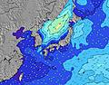 | 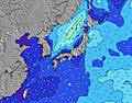 | 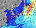 | 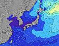 | ||||||||||||||
Wave Height (m) Direction Period (s) | SE 16 | SE 17 | SE 16 | SE 16 | SE 16 | SE 16 | SE 16 | SE 16 | SSE 15 | SSE 15 | S 15 | SSE 15 | S 15 | S 15 | S 14 | SSW 14 | SSW 14 | SSW 15 | SSW 15 | SSW 16 | SSW 15 |
Wave Graph | |||||||||||||||||||||
1901 | 2970 | 3569 | 6018 | 6568 | 6731 | 8064 | 7832 | 5601 | 4986 | 4752 | 5059 | 3107 | 2153 | 1640 | 1325 | 1189 | 1137 | 894 | 938 | 539 | |
Wind (km/h) | |||||||||||||||||||||
Wind State on-shore cross-onshore cross-shore cross-offshore off-shore glassy | cross-off | cross | cross | cross-off | cross | cross-off | cross-off | cross | cross-off | cross-on | cross-on | cross-on | cross-on | cross-on | cross-on | cross-on | cross-on | cross | cross | cross | cross-off |
High Tide | 7:27PM1.38m | 7:32AM1.21m | 7:51PM1.38m | 8:31AM1.11m | 8:17PM1.37m | 9:58AM1.02m | 8:49PM1.35m | 12:56PM1.00m | 9:31PM1.33m | 10:43PM1.31m | 4:10PM1.23m | 00:23AM1.32m | |||||||||
Low Tide | 1:00PM0.40m | 1:40AM0.55m | 1:27PM0.54m | 2:28AM0.50m | 1:55PM0.69m | 3:27AM0.45m | 2:20PM0.85m | 4:43AM0.41m | 2:29PM1.00m | 6:13AM0.33m | 7:36AM0.23m | 7:43PM1.16m | |||||||||
4:48 | — | — | 4:48 | — | — | 4:50 | — | — | 4:50 | — | — | 4:50 | — | — | 4:52 | — | — | 4:52 | — | — | |
— | 6:39 | — | — | 6:39 | — | — | 6:38 | — | — | 6:37 | — | — | 6:37 | — | — | 6:36 | — | — | 6:35 | — | |
mm | — | — | — | — | — | — | — | — | 3 | 2 | 1 | 3 | 4 | 2 | 2 | — | — | — | — | — | — |
Temp °C | 24 | 25 | 23 | 24 | 24 | 23 | 25 | 26 | 25 | 28 | 28 | 26 | 27 | 27 | 26 | 27 | 27 | 24 | 26 | 25 | 23 |
Feels °C | 23 | 23 | 21 | 21 | 21 | 21 | 24 | 26 | 27 | 30 | 30 | 28 | 29 | 28 | 29 | 29 | 28 | 25 | 23 | 21 | 19 |
Swell 1 Height (m) Direction Period (s) | SE 16 | SE 17 | SE 16 | SE 16 | SE 16 | SE 16 | SE 16 | SE 16 | SSE 15 | SSE 15 | S 15 | SSE 15 | S 15 | S 15 | S 14 | SSW 14 | SE 9 | ESE 12 | ESE 13 | ESE 13 | E 7 |
1901 | 2970 | 3569 | 6018 | 6568 | 6731 | 8064 | 7832 | 5601 | 4986 | 4752 | 5059 | 3107 | 2153 | 1640 | 1325 | 461 | 893 | 894 | 711 | 261 | |
Swell 2 Height (m) Direction Period (s) | E 14 | E 14 | E 14 | E 14 | E 13 | E 13 | E 18 | — | E 17 | E 16 | ESE 9 | E 15 | ESE 9 | SE 9 | ESE 9 | SE 9 | SSW 14 | SSW 15 | SSW 15 | SSW 16 | ESE 13 |
34 | 61 | 59 | 57 | 54 | 87 | 25 | — | 22 | 20 | 329 | 41 | 441 | 491 | 440 | 514 | 1189 | 1137 | 886 | 938 | 461 | |
Swell 3 Height (m) Direction Period (s) | E 14 | — | — | E 13 | — | — | — | — | E 12 | ENE 16 | E 16 | ENE 15 | E 15 | E 15 | E 14 | E 14 | SE 12 | ENE 14 | ENE 13 | — | SSW 15 |
97 | — | — | 92 | — | — | — | — | 66 | 51 | 20 | 45 | 39 | 39 | 37 | 36 | 157 | 38 | 34 | — | 539 | |
Wind waves Height (m) Direction Period (s) | NE 6 | ENE 7 | ENE 7 | ENE 7 | ENE 7 | ENE 7 | — | E 8 | — | — | — | — | — | ESE 9 | — | — | — | — | — | ENE 4 | NNE 5 |
126 | 175 | 223 | 406 | 455 | 301 | — | 454 | — | — | — | — | — | 601 | — | — | — | — | — | 42 | 56 | |
Nearest Offshore or Glassy | |||||||||||||||||||||
Distance (km) | 533 | 49 | 204 | 204 | 49 | 555 | 552 | 49 | 49 | 49 | 2266 | 74 | 2340 | 115 | 19 | 49 | 115 | 42 | 2642 | 2266 | 629 |
Best forecast wave conditions in Chiba | |||||||||||||||||||||
Best forecast wave conditions in Japan | |||||||||||||||||||||
Header Global | |||||||||||||||||||||
- Map Icons:
 Break
Break Live Wave Height (m)
 Live Wind Speed (km/h)
 Surf Rating (10 Max)
 Ocean Swells (m)
- Wind Speed (km/h)
Latest Updates


FREE! Surf-Forecast.com widget for your website
The surf report / weather widget below is available to embed on third party websites free of charge and provides a summary of our Hebara surf forecast. Simply grab the html code snippet that we provide and paste it into your own site. You can choose your preferred language and metric/imperial units for the surf forecast feed to suit users of your site. Click here to get the code.
Information about the Hebara Surf forecast
The above surf forecast table for Hebara provides essential information for determining whether the surfing conditions will be good over the next 16 days. A general guide to surfing at Hebara can be found by selecting the local surf guide option on the grey menu. Our Hebara surf forecast is unique since it includes wave energy (power) that defines the real feel of the surf rather than just the height or the period. If you surf the same spot (Hebara) regularly then make a mental note of the wave energy from the surf forecast table each time you go. Very soon you may start to choose your surf days based on the wave energy alone combined with our forecast of favourable offshore wind conditions. Our star ratings will help here and of course you will also find the usual wave height and period predictions on our surf forecasts as well as a full break down of the swell components under our advanced users option (to reveal that, click the little Einstein character under the tide times).
Further information to help with frequently asked questions about our surf forecast for Hebara may be found under the help tab on the top menu and also by moving your mouse over the question marks on the surf forecast table itself. Please always bear in mind that the forecast is for near-shore open water and local factors at each surf break influence the actual breaking wave height, such as the beach / reef profile, water depths offshore and shelter.
Hebara is 8 km (5 miles) from Ohara. If you plan a holiday in Chiba, look for hotels and other accommodation in Ohara. Ohara has rooms for a wide range of budgets as well as car hire and transport links.
 Nearest