

Surf Forecasts:

Grand Sancho surf forecast from 15 Jul 2026:
- Best quality surf: Tuesday 21 Jul, 4AM (local time) - 6ft (1.9m), 13s period, SW swell with cross-offshore winds.
- Most powerful swell: Wednesday 22 Jul, 10AM (local time) - 7.5ft (2.3m), 14s period, SSW swell with 2,064 kJ wave energy.
- Next surfable swell (1★+): Thursday 16 Jul, 4AM (local time) - 6ft (1.9m), 8s period with ESE swell.
Best Forecast Surf Conditions for Grand Sancho this week:
The surf forecast for Grand Sancho over the next 16 days: The first swell (rated 1 star or higher) is forecast to arrive on Thursday (Jul 16) at 4AM. The primary swell is predicted to be 1.9m and 8s period with a secondary swell of 0.9m and 12s. The wind is predicted to be offshore as the swell arrives.
The most powerful waves expected at Grand Sancho in the next 16 days are 2.3m 14s and forecast to arrive on Wednesday (Jul 22) at 10AM. Winds are predicted to be cross-onshore at the time the swell arrives. The largest open ocean swell (not directed at the beach) is 0.4m 3s period and expected on Friday (Jul 17) at 4AM.
| Wave Type | Time (+04) & Date | Wave Height & Period |
|---|---|---|
| Next good surf (1 star+) | 4AM (Thu 16th Jul) | 6ft (1.9m) 8s |
| Best Surf | 4AM (Tue 21st Jul) | 6ft (1.9m) 13s |
| Most Powerful | 10AM (Wed 22nd Jul) | 7.5ft (2.3m) 14s |
Table - best surf conditions forecast for Grand Sancho over the next 16 days.
The Lowdown
Alright folks, Rusty here. Let’s talk about what’s cooking at Grand Sancho.
Right off the bat, we’ve got a solid run of surf on the way, but it’s a mixed bag of conditions. The first few days are the real standouts, with some later windows that need a bit of forgiving weather.
Thursday the 16th kicks things off with a clean 6ft swell from the ESE, period around 9 seconds. The wind is light and offshore from the North in the morning, going cross-off in the arvo. Water temps are about average for this time of year. The energy is moderate (756), but the combo of clean conditions and that size makes for a cracking start. The 6ft is a fun size for intermediates, not too gnarly. After that, the wind holds up through Friday morning the 17th with a tiny 3ft but a very long 17-second period from the S. That’s proper groundswell energy (765), and with a light cross-off breeze, it’ll be glassy. A long period like that loves a point break like Grand Sancho, so expect some lined-up, hollow walls. The afternoon turns a bit cross-shore and the surf bumps to 4ft, but it’s still clean enough.
Saturday the 18th is a bit of a write-off. Onshore wind from the SSW and dropping swell (4ft) means it’s messy and not worth chasing. Sunday the 19th is also no good, with onshore winds and a dropping, weak swell.
Now, the next standout is Monday the 20th. Glassy conditions in the morning with a 5ft SSW groundswell (14-second period). That’s a serious amount of energy (1217) and the wind is dead calm. The wave state is glassy. This is your best bet for the first week. The afternoon gets a bit cross-on and the swell jumps to 7ft, which is still surfable but a bit less clean.
Tuesday the 21st through Wednesday the 22nd sees the swell build. Tuesday morning is 6ft but cross-on, so it’s a bit bumpy. By Wednesday the 22nd, the swell hits 8ft from the SSW with a 14-second period. That’s a lot of water (2191), but the wind is cross-on and choppy in the morning. This is getting into the bigger end of intermediate territory, and the conditions aren’t perfect. Not a standout, but there’s grunt.
Thursday the 23rd is a bit smaller at 6ft with a light cross-shore breeze, which is an improvement, but it’s still not the cleanest. Friday the 24th has a promising 5ft swell with a very long 17-second period and a light cross-shore breeze in the morning. That’s a sneaky good session – the period is long, but it’s manageable size. The energy is high (1638) for that size.
Looking further ahead into the second week, things get more unpredictable. Saturday the 25th is 6ft but gets blown out in the afternoon. Sunday the 26th has a big 8ft swell from the SSW with a 16-second period. That’s a heavy amount of energy (4153) and a light cross-shore breeze in the morning. This is proper expert territory size-wise. The wind will be the deciding factor. After that, from Monday the 27th through to Friday the 31st, the swell stays big (7ft to 8ft) but the wind is consistently cross-on and fresh, making it choppy and lumpy. The energy is through the roof (up to 6791), but it’s not a paddle-friendly setup. For a beach and point break, this looks more like a kite surfing session than a good paddle surf.
The bottom line: The best windows are Thursday 16th and Monday 20th for the most balanced, clean conditions. The Friday 17th morning and Friday 24th morning offer that long-period magic in smaller, cleaner sizes. The later big swell days (26th onwards) are for experts only, and only if the wind predictions hold.
Rusty.
Short Range ForecastSome drizzle, heaviest during Fri afternoon. Warm (max 26°C on Thu morning, min 21°C on Thu night). Wind will be generally light. | Days 5-7 Weather SummaryMostly dry. Warm (max 24°C on Mon morning, min 20°C on Sun night). Wind will be generally light. | ||||||||||||||||||||
Thursday 16 | Friday 17 | Saturday 18 | Sunday 19 | Monday 20 | Tuesday 21 | Wed 22 | |||||||||||||||
Night | AM | PM | Night | AM | PM | Night | AM | PM | Night | AM | PM | Night | AM | PM | Night | AM | PM | Night | AM | PM | |
Swell Height Map |  | 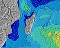 | 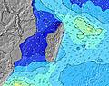 | 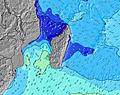 | 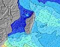 | 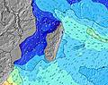 | 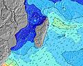 | 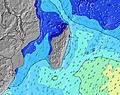 | |||||||||||||
Wave Height (m) Direction Period (s) | ESE 9 | ESE 9 | ESE 9 | ESE 8 | S 17 | S 16 | S 15 | SSW 13 | S 13 | E 9 | SW 16 | SW 15 | SW 14 | SW 14 | SSW 14 | SSW 13 | SSW 12 | SSW 12 | SSW 11 | SSW 14 | SSW 13 |
Wave Graph | |||||||||||||||||||||
541 | 566 | 566 | 389 | 371 | 858 | 836 | 539 | 334 | 161 | 310 | 438 | 459 | 1094 | 1509 | 1401 | 795 | 647 | 527 | 2064 | 1700 | |
Wind (km/h) | |||||||||||||||||||||
Wind State on-shore cross-onshore cross-shore cross-offshore off-shore glassy | cross-off | off | cross-off | cross-off | cross-off | cross | on | on | on | on | on | on | cross | glassy | cross-on | cross | cross-on | cross-on | cross | cross-on | cross-on |
High Tide | 1:34AM0.80m | 2:27PM0.69m | 2:12AM0.78m | 3:01PM0.68m | 2:47AM0.73m | 3:33PM0.65m | 3:21AM0.67m | 4:02PM0.63m | 3:53AM0.60m | 4:33PM0.59m | 4:29AM0.52m | 5:08PM0.56m | 5:19AM0.44m | 6:04PM0.52m | |||||||
Low Tide | 8:09AM-0.02m | 8:10PM0.17m | 8:44AM0.03m | 8:48PM0.20m | 9:17AM0.09m | 9:25PM0.23m | 9:47AM0.16m | 10:05PM0.27m | 10:14AM0.23m | 10:51PM0.30m | 10:40AM0.29m | 11:59PM0.33m | 11:08AM0.35m | ||||||||
— | 6:46 | — | — | 6:45 | — | — | 6:45 | — | — | 6:45 | — | — | 6:45 | — | — | 6:45 | — | — | 6:43 | — | |
— | — | 5:45 | — | — | 5:45 | — | — | 5:46 | — | — | 5:46 | — | — | 5:46 | — | — | 5:47 | — | — | 5:47 | |
mm | — | — | — | — | — | 1 | — | — | — | — | — | — | — | — | — | — | — | — | — | — | — |
Temp °C | 23 | 26 | 25 | 23 | 25 | 25 | 23 | 23 | 23 | 22 | 23 | 23 | 21 | 24 | 23 | 21 | 23 | 23 | 21 | 23 | 23 |
Feels °C | 25 | 27 | 26 | 25 | 26 | 25 | 25 | 24 | 23 | 23 | 23 | 23 | 22 | 24 | 24 | 22 | 23 | 22 | 21 | 23 | 23 |
Swell 1 Height (m) Direction Period (s) | ESE 9 | ESE 9 | ESE 9 | ESE 8 | ESE 8 | ESE 9 | S 15 | SSW 13 | E 8 | E 9 | ESE 8 | SW 15 | SW 14 | SW 14 | SSW 14 | SSW 13 | SSW 12 | SSW 12 | SSW 11 | SSW 14 | SSW 13 |
541 | 566 | 566 | 389 | 293 | 297 | 836 | 539 | 144 | 151 | 112 | 438 | 459 | 1094 | 1509 | 1401 | 795 | 647 | 527 | 2064 | 1700 | |
Swell 2 Height (m) Direction Period (s) | SSW 12 | S 10 | SSW 12 | S 13 | S 17 | S 16 | E 8 | ESE 8 | S 13 | SSW 11 | SW 16 | ESE 8 | ESE 8 | E 8 | E 8 | E 8 | E 8 | E 8 | SE 11 | — | S 13 |
230 | 96 | 90 | 167 | 371 | 858 | 205 | 176 | 334 | 161 | 310 | 112 | 87 | 84 | 86 | 86 | 84 | 84 | 5 | — | 3 | |
Swell 3 Height (m) Direction Period (s) | S 10 | SSW 12 | S 10 | SW 11 | S 12 | SSW 11 | W 4 | SW 4 | SW 5 | SW 18 | SSW 10 | SSW 10 | SSW 15 | SSE 11 | SSW 8 | SSE 10 | SSE 10 | SW 16 | SW 15 | — | — |
65 | 94 | 32 | 63 | 101 | 12 | 3 | 9 | 13 | 152 | 77 | 37 | 169 | 39 | 7 | 19 | 9 | 10 | 8 | — | — | |
Wind waves Height (m) Direction Period (s) | — | — | — | NW 4 | NW 3 | — | — | — | — | — | — | — | — | — | — | — | — | — | E 8 | E 8 | E 8 |
— | — | — | 2 | 3 | — | — | — | — | — | — | — | — | — | — | — | — | — | 84 | 127 | 120 | |
Nearest Offshore or Glassy | |||||||||||||||||||||
Distance (km) | 0 | 0 | 0 | 0 | 0 | 26 | 9 | 9 | 9 | 9 | 9 | 9 | 0 | 0 | 9 | 0 | 7 | 9 | 0 | 7 | 16 |
Best forecast wave conditions in Mauritius | |||||||||||||||||||||
Best forecast wave conditions in Mauritius | |||||||||||||||||||||
Header Global | |||||||||||||||||||||
- Map Icons:
 Break
Break Live Wave Height (m)
 Live Wind Speed (km/h)
 Surf Rating (10 Max)
 Ocean Swells (m)
- Wind Speed (km/h)


FREE! Surf-Forecast.com widget for your website
The surf report / weather widget below is available to embed on third party websites free of charge and provides a summary of our Grand Sancho surf forecast. Simply grab the html code snippet that we provide and paste it into your own site. You can choose your preferred language and metric/imperial units for the surf forecast feed to suit users of your site. Click here to get the code.
Information about the Grand Sancho Surf forecast
The above surf forecast table for Grand Sancho provides essential information for determining whether the surfing conditions will be good over the next 16 days. A general guide to surfing at Grand Sancho can be found by selecting the local surf guide option on the grey menu. Our Grand Sancho surf forecast is unique since it includes wave energy (power) that defines the real feel of the surf rather than just the height or the period. If you surf the same spot (Grand Sancho) regularly then make a mental note of the wave energy from the surf forecast table each time you go. Very soon you may start to choose your surf days based on the wave energy alone combined with our forecast of favourable offshore wind conditions. Our star ratings will help here and of course you will also find the usual wave height and period predictions on our surf forecasts as well as a full break down of the swell components under our advanced users option (to reveal that, click the little Einstein character under the tide times).
Further information to help with frequently asked questions about our surf forecast for Grand Sancho may be found under the help tab on the top menu and also by moving your mouse over the question marks on the surf forecast table itself. Please always bear in mind that the forecast is for near-shore open water and local factors at each surf break influence the actual breaking wave height, such as the beach / reef profile, water depths offshore and shelter.
Grand Sancho is 22 km (14 miles) from the city of Curepipe. If you plan a holiday in Mauritius, look for hotels and other accommodation in Curepipe. Curepipe has rooms for a wide range of budgets as well as car hire and transport links.
 Nearest