

Surf Forecasts:

El Canyon surf forecast from 2 Aug 2026:
Best Forecast Surf Conditions for El Canyon this week:
The largest open ocean swell (not directed at the beach) is 1.6m 8s period and expected on Sunday (Aug 02) at 6PM.
The Lowdown
Alright, let’s get this straight. I’ve looked at the next sixteen days for El Canyon, and I’ve got some good news and some bad news. The bad news is, we’re looking at a pretty bleak stretch of surf for a while. The good news? Well, it’s not going to stay flat forever, and the forecast is showing some signs of life towards the end of the run.
Right now, and for the next week and a half, there’s just nothing to work with. The swell energy is reading at zero (0) for most of that time. The wind is actually going to be mostly offshore or cross-off, so the surface is going to be clean. But a clean, flat ocean doesn’t do us any good. We’re just going to have to watch the horizon and wait. There’s a bit of a gap of nearly two weeks with no good surf on offer.
When we finally do see something, it’s not going to be much. Around the 15th of August, there’s a tiny pulse of swell showing. It’s weak, with a combined energy of only 6. That’s about as weak as it gets. It’s from the northwest with a period around 12 seconds, but it’s only 0.3ft. That’s not rideable.
The following morning, the 16th of August, there’s a little more consistency in the forecast, but still tiny. In the afternoon, the swell might bump up to 0.3ft with a period of 19 seconds. That’s a long-period groundswell, but with that size, it’s still not going to break properly. It’ll just be a bunch of water moving around. By Monday the 17th, the morning shows a similar 0.3ft of swell (12) from the northwest before it fades again.
So, here’s the bottom line. If you’re a beginner, you have nothing to worry about. If you’re a seasoned surfer, you’re probably going to be doing something else for the next two weeks. The water temp is a major wildcard, though. The first session I see, the water is 80°, which is 10° warmer than average. That is extremely unusual and will feel like a bath. The forecast is for a change, but this is a long-range call, so it’s promising but not something I’d bet the farm on. Keep an eye on it, but don't hold your breath.
Rusty
Short Range ForecastMostly dry. Warm (max 25°C on Sun morning, min 24°C on Sun afternoon). Wind will be generally light. | Days 4-6 Weather SummaryMostly dry. Warm (max 24°C on Wed morning, min 23°C on Thu night). Wind will be generally light. | ||||||||||||||||||||
Sunday 2 | Monday 3 | Tuesday 4 | Wednesday 5 | Thursday 6 | Friday 7 | Saturday 8 | |||||||||||||||
AM | PM | Night | AM | PM | Night | AM | PM | Night | AM | PM | Night | AM | PM | Night | AM | PM | Night | AM | PM | Night | |
Swell Height Map | 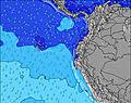 | 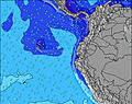 | 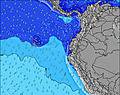 | 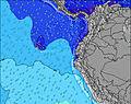 | 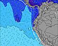 |  | 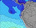 | ||||||||||||||
Wave Height (m) Direction Period (s) | SSE 8 | SSE 8 | SSE 8 | SSE 8 | SSE 8 | SSE 8 | SSE 8 | SSE 8 | SSE 8 | SW 14 | SSW 13 | SW 13 | SSW 18 | SSW 16 | SW 16 | SSW 15 | SSW 14 | SSW 14 | SSW 14 | SW 13 | SSW 13 |
Wave Graph | |||||||||||||||||||||
0 | 0 | 0 | 0 | 0 | 0 | 0 | 0 | 0 | 0 | 0 | 0 | 0 | 0 | 0 | 0 | 0 | 0 | 0 | 0 | 0 | |
Wind (km/h) | |||||||||||||||||||||
Wind State on-shore cross-onshore cross-shore cross-offshore off-shore glassy | cross-off | cross-off | cross-off | cross-off | cross-off | cross-off | cross-off | cross-off | cross-off | cross-off | cross-off | cross-off | cross-off | cross-off | cross-off | off | cross-off | cross-off | off | off | off |
High Tide | 5:08PM1.88m | 5:32AM2.01m | 5:46PM1.84m | 6:09AM1.98m | 6:29PM1.78m | 6:52AM1.92m | 7:20PM1.71m | 7:42AM1.85m | 8:22PM1.64m | 8:45AM1.79m | 9:36PM1.62m | 9:58AM1.75m | 10:56PM1.66m | ||||||||
Low Tide | 11:08AM0.35m | 11:15PM0.28m | 11:45AM0.35m | 11:52PM0.33m | 12:25PM0.37m | 00:32AM0.40m | 1:11PM0.42m | 1:20AM0.49m | 2:06PM0.46m | 2:19AM0.59m | 3:13PM0.50m | 3:34AM0.65m | 4:30PM0.49m | ||||||||
6:01 | — | — | 6:01 | — | — | 6:01 | — | — | 6:01 | — | — | 6:01 | — | — | 6:01 | — | — | 6:01 | — | — | |
— | 6:07 | — | — | 6:07 | — | — | 6:06 | — | — | 6:06 | — | — | 6:06 | — | — | 6:06 | — | — | 6:06 | — | |
mm | — | — | — | — | — | — | — | — | — | — | — | — | — | — | — | — | — | — | — | — | — |
Temp °C | 25 | 25 | 24 | 25 | 25 | 24 | 24 | 24 | 24 | 24 | 24 | 24 | 24 | 24 | 24 | 24 | 24 | 24 | 25 | 25 | 25 |
Feels °C | 24 | 24 | 23 | 26 | 25 | 25 | 24 | 24 | 24 | 24 | 24 | 24 | 23 | 24 | 25 | 25 | 25 | 25 | 26 | 25 | 26 |
Swell 1 Height (m) Direction Period (s) | SSW 13 | SW 13 | SSW 12 | SW 12 | SW 12 | SW 12 | SW 11 | SW 14 | SW 13 | SSE 8 | SSE 8 | SSE 8 | SSE 8 | SSW 16 | SW 16 | SSW 15 | SSW 14 | SSW 14 | SSW 14 | SW 13 | SSW 13 |
116 | 84 | 101 | 74 | 120 | 36 | 46 | 89 | 162 | 172 | 176 | 171 | 116 | 475 | 1044 | 608 | 701 | 682 | 493 | 394 | 286 | |
Swell 2 Height (m) Direction Period (s) | SW 10 | SW 13 | SW 16 | SW 15 | N 8 | SW 15 | SW 14 | S 12 | S 12 | SW 14 | SSW 13 | SW 13 | SSW 18 | SW 12 | SSE 8 | SSE 8 | SSE 8 | SSE 8 | S 10 | S 10 | SW 16 |
50 | 84 | 64 | 57 | 12 | 54 | 54 | 45 | 69 | 293 | 309 | 245 | 390 | 144 | 94 | 75 | 73 | 69 | 17 | 8 | 127 | |
Swell 3 Height (m) Direction Period (s) | SW 13 | SSW 10 | SW 12 | N 9 | WSW 12 | SW 12 | S 13 | SW 10 | SSW 19 | S 11 | S 12 | SW 18 | SW 12 | SW 12 | S 11 | SW 11 | S 11 | S 10 | SSW 18 | SSW 18 | S 10 |
45 | 35 | 40 | 14 | 14 | 21 | 28 | 17 | 37 | 89 | 42 | 161 | 147 | 37 | 21 | 58 | 20 | 18 | 31 | 31 | 7 | |
Wind waves Height (m) Direction Period (s) | SSE 8 | SSE 8 | SSE 8 | SSE 8 | SSE 8 | SSE 8 | SSE 8 | SSE 8 | SSE 8 | — | — | — | — | SSE 8 | — | — | — | — | SSE 8 | SSE 8 | SSE 8 |
266 | 314 | 253 | 215 | 215 | 221 | 206 | 206 | 206 | — | — | — | — | 113 | — | — | — | — | 69 | 80 | 69 | |
Nearest Offshore or Glassy | |||||||||||||||||||||
Distance (km) | 94 | 1237 | 996 | 977 | 1294 | 980 | 977 | 1298 | 977 | 977 | 1263 | 94 | 977 | 94 | 1 | 1 | 1 | 1 | 1010 | 1264 | 1 |
Best forecast wave conditions in Galapagos - San Cristobal | |||||||||||||||||||||
Best forecast wave conditions in Ecuador | |||||||||||||||||||||
Header Global | |||||||||||||||||||||
- Map Icons:
 Break
Break Live Wave Height (m)
 Live Wind Speed (km/h)
 Surf Rating (10 Max)
 Ocean Swells (m)
- Wind Speed (km/h)
Latest Updates


FREE! Surf-Forecast.com widget for your website
The surf report / weather widget below is available to embed on third party websites free of charge and provides a summary of our El Canyon surf forecast. Simply grab the html code snippet that we provide and paste it into your own site. You can choose your preferred language and metric/imperial units for the surf forecast feed to suit users of your site. Click here to get the code.
Information about the El Canyon Surf forecast
The above surf forecast table for El Canyon provides essential information for determining whether the surfing conditions will be good over the next 16 days. A general guide to surfing at El Canyon can be found by selecting the local surf guide option on the grey menu. Our El Canyon surf forecast is unique since it includes wave energy (power) that defines the real feel of the surf rather than just the height or the period. If you surf the same spot (El Canyon) regularly then make a mental note of the wave energy from the surf forecast table each time you go. Very soon you may start to choose your surf days based on the wave energy alone combined with our forecast of favourable offshore wind conditions. Our star ratings will help here and of course you will also find the usual wave height and period predictions on our surf forecasts as well as a full break down of the swell components under our advanced users option (to reveal that, click the little Einstein character under the tide times).
Further information to help with frequently asked questions about our surf forecast for El Canyon may be found under the help tab on the top menu and also by moving your mouse over the question marks on the surf forecast table itself. Please always bear in mind that the forecast is for near-shore open water and local factors at each surf break influence the actual breaking wave height, such as the beach / reef profile, water depths offshore and shelter.
Are you planning a holiday in Galapagos - San Cristobal? If you are looking for accommodation near El Canyon, camping, hotels and holiday cottages in Galapagos - San Cristobal, consider staying in Galapagos Islands which is 3 km (2 miles) away. Other places in and around Galapagos - San Cristobal where you can find information about places to rent, and car hire include San Cristobal which is 52 km (32 miles) away and Bahia de la Academia, 79 km (49 miles) away.
 Nearest