

Surf Forecasts:

Mompiche surf forecast from 2 Aug 2026:
- Best quality surf: Monday 3 Aug, 1AM (local time) - 2ft (0.6m), 13s period, WSW swell with cross-offshore winds.
- Most powerful swell: Sunday 2 Aug, 1PM (local time) - 3.5ft (1.1m), 12s period, SW swell with 349 kJ wave energy.
- Next surfable swell (1★+): Monday 3 Aug, 1AM (local time) - 2ft (0.6m), 13s period with WSW swell.
Best Forecast Surf Conditions for Mompiche this week:
The surf forecast for Mompiche over the next 16 days: The first swell (rated 1 star or higher) is forecast to arrive on Monday (Aug 03) at 1AM. The primary swell is predicted to be 0.6m and 13s period with a secondary swell of 0.6m and 11s. The wind is predicted to be cross-offshore as the swell arrives.
The most powerful waves expected at Mompiche in the next 16 days are 1.1m 12s and forecast to arrive on Sunday (Aug 02) at 1PM. Winds are predicted to be cross-shore at the time the swell arrives. The largest open ocean swell (not directed at the beach) is 1.1m 5s period and expected on Sunday (Aug 02) at 4PM.
| Wave Type | Time (-05) & Date | Wave Height & Period |
|---|---|---|
| Next good surf (1 star+) | 1AM (Mon 3rd Aug) | 2ft (0.6m) 13s |
| Best Surf | 1AM (Mon 3rd Aug) | 2ft (0.6m) 13s |
| Most Powerful | 1PM (Sun 2nd Aug) | 3.5ft (1.1m) 12s |
Table - best surf conditions forecast for Mompiche over the next 16 days.
The Lowdown
Alright folks, Rusty here. Let’s get into it. We’re looking at a pretty quiet run ahead for Mompiche, but there’s a glimmer of something better if you’re willing to wait.
First thing you need to know – the water is cooking. At 81°F with a 5°F anomaly, that’s much warmer than normal for this time of year. You’ll be surfing in a bath, so leave the thick rubber at home.
The next few days are flat and weak. We’ve got a long stretch of small, low-energy surf. Sunday morning, the 2nd, you might see a tiny 2ft swell from the SW with a touch of cross-off wind, but the energy is a limp 260 (weak) – it’s marginal at best. Monday the 3rd and Tuesday the 4th don’t offer much either. Tuesday morning the energy drops to 93 (very weak). It’s a bit of a slog. Wednesday the 5th is clean but small, with a 2ft SW swell and 111 (weak) energy. Still just surfable, nothing special.
The pattern holds through the first week. The swell tries to nudge up by Friday the 7th morning with 3ft from the SW and 318 (moderate) energy, but the wind is cross, so conditions are iffy. Saturday the 8th is similar, with clean cross-off winds in the morning but the swell is still only 3ft. The energy sits at 268 (moderate). It’s surfable, but don’t plan your day around it.
Then we hit a real dead zone. From Sunday the 9th through to Thursday the 13th, the energy drops back into the weak range, with swells barely hitting 2ft. It’s a long flat gap. The 10th has a weird 19-second period on the afternoon – that’s a long groundswell, but at only 1ft, it’s a ghost. Not worth the paddle.
Now, here’s where it gets interesting. The real standout comes in the second week. Friday the 14th morning sees a 3ft WSW swell with 399 (strong) energy – that’s the most juice we’ve seen all outlook. Light cross winds, clean. But it’s still early days, so take it as a promising sign.
The best window is Saturday the 15th and Sunday the 16th. Saturday morning we get 3ft from the WSW with cross-off SSW winds, 308 (moderate) energy, and the forecast says "expect good surf conditions." This is the pick. The swell direction is WSW, and the optimum swell for Mompiche’s point break is NW, so it’s not perfect, but the wind is clean and the wave quality should be there. Sunday the 16th morning is also a goer, with 2ft from the SW, 276 (moderate) energy, and cross-off winds. Clean again.
Then Monday the 17th morning delivers the biggest combo: 2ft SW swell, 405 (strong) energy, and cross-off winds. The swell period is 14 seconds, a nice groundswell. That’s the best energy of the whole run. The afternoon pushes 3ft from the SW with 579 (strong) energy, but the wind swings cross-on, so the morning is where it’s at.
The standout here: Saturday 15th August morning at Mompiche. It’s not huge, but the combination of clean cross-off wind, moderate energy, and a decent 3ft SW swell makes it the best bet. Get out there early, because the afternoons get choppy.
If you’re a beginner, the swell never gets over 5ft, so it’s safe for learning. The period is generally in the 10-14 second range, which gives reasonable shape for a point break. Just don’t expect any barrels.
Rusty.
Short Range ForecastLight rain (total 5mm), mostly falling on Sun night. Warm (max 27°C on Sun morning, min 24°C on Sun night). Wind will be generally light. | Days 4-6 Weather SummaryMostly dry. Warm (max 26°C on Wed morning, min 24°C on Thu night). Wind will be generally light. | ||||||||||||||||||||
Sunday 2 | Monday 3 | Tuesday 4 | Wednesday 5 | Thursday 6 | Friday 7 | Saturday 8 | |||||||||||||||
AM | PM | Night | AM | PM | Night | AM | PM | Night | AM | PM | Night | AM | PM | Night | AM | PM | Night | AM | PM | Night | |
Swell Height Map | 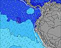 | 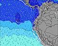 | 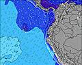 | 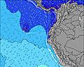 | 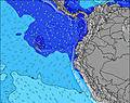 | 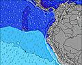 | 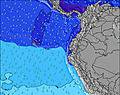 | ||||||||||||||
Wave Height (m) Direction Period (s) | SW 12 | SW 11 | WSW 13 | WSW 13 | WSW 13 | SW 10 | SW 12 | SW 12 | SW 9 | SW 13 | SW 12 | SW 14 | SW 13 | SW 13 | SW 18 | SW 12 | WSW 16 | SW 16 | SW 14 | SW 14 | SW 13 |
Wave Graph | |||||||||||||||||||||
114 | 103 | 120 | 118 | 114 | 136 | 73 | 71 | 62 | 84 | 55 | 162 | 140 | 171 | 152 | 175 | 173 | 193 | 248 | 241 | 215 | |
Wind (km/h) | |||||||||||||||||||||
Wind State on-shore cross-onshore cross-shore cross-offshore off-shore glassy | cross-off | cross | cross-off | cross-off | cross | cross | cross | cross | cross | cross-off | cross-on | cross | cross | cross | cross-off | cross | cross-on | cross | cross-off | cross | cross |
High Tide | 6:12PM2.69m | 6:34AM2.87m | 6:50PM2.64m | 7:11AM2.82m | 7:32PM2.56m | 7:52AM2.75m | 8:20PM2.46m | 8:40AM2.66m | 9:18PM2.37m | 9:40AM2.56m | 10:28PM2.31m | 10:51AM2.51m | 11:48PM2.35m | ||||||||
Low Tide | 12:10PM0.49m | 00:18AM0.40m | 12:47PM0.49m | 00:55AM0.48m | 1:27PM0.51m | 1:35AM0.57m | 2:13PM0.56m | 2:22AM0.68m | 3:06PM0.61m | 3:20AM0.79m | 4:11PM0.65m | 4:32AM0.86m | 5:25PM0.63m | ||||||||
6:22 | — | — | 6:22 | — | — | 6:22 | — | — | 6:22 | — | — | 6:20 | — | — | 6:20 | — | — | 6:20 | — | — | |
— | 6:30 | — | — | 6:30 | — | — | 6:30 | — | — | 6:30 | — | — | 6:30 | — | — | 6:29 | — | — | 6:29 | — | |
mm | — | — | 4 | — | — | — | — | — | 1 | — | — | — | — | — | — | — | — | — | 2 | — | — |
Temp °C | 27 | 26 | 25 | 26 | 26 | 25 | 26 | 26 | 25 | 26 | 26 | 25 | 26 | 26 | 25 | 26 | 26 | 25 | 26 | 26 | 25 |
Feels °C | 28 | 27 | 27 | 28 | 28 | 28 | 28 | 28 | 27 | 28 | 28 | 28 | 28 | 27 | 28 | 29 | 28 | 29 | 28 | 27 | 28 |
Swell 1 Height (m) Direction Period (s) | SW 12 | SW 11 | SW 11 | WSW 13 | WSW 13 | SW 12 | SW 5 | SW 12 | SW 12 | SW 13 | SW 12 | SW 14 | SW 13 | SW 13 | WSW 13 | SW 12 | SW 12 | SW 16 | SW 14 | SW 14 | SW 13 |
114 | 103 | 90 | 118 | 114 | 77 | 20 | 71 | 49 | 84 | 55 | 162 | 140 | 171 | 116 | 175 | 141 | 193 | 248 | 241 | 215 | |
Swell 2 Height (m) Direction Period (s) | WSW 15 | WSW 15 | WSW 13 | SW 10 | SW 10 | WNW 11 | SW 12 | SW 9 | WNW 10 | SSW 8 | SSW 9 | WNW 9 | SW 19 | SW 19 | WSW 4 | SW 16 | WSW 16 | SW 12 | WSW 11 | WSW 11 | SW 18 |
85 | 84 | 120 | 54 | 34 | 23 | 73 | 21 | 10 | 6 | 7 | 8 | 56 | 54 | 10 | 130 | 173 | 112 | 12 | 12 | 13 | |
Swell 3 Height (m) Direction Period (s) | NW 11 | WNW 12 | NW 11 | NW 11 | NW 11 | — | SW 9 | WNW 10 | WSW 15 | WNW 10 | WSW 11 | SW 21 | NW 9 | NW 9 | SW 18 | WNW 8 | — | WNW 9 | WNW 9 | NW 9 | W 6 |
30 | 53 | 30 | 32 | 31 | — | 20 | 10 | 21 | 9 | 12 | 17 | 3 | 3 | 152 | 13 | — | 8 | 8 | 3 | 1 | |
Wind waves Height (m) Direction Period (s) | SW 5 | SW 5 | SW 5 | SW 5 | SW 5 | SW 10 | — | WSW 5 | SW 9 | SW 4 | SW 4 | WSW 4 | SW 4 | WSW 4 | — | — | W 9 | WSW 9 | SW 4 | SW 4 | SW 5 |
31 | 51 | 43 | 28 | 35 | 136 | — | 17 | 62 | 18 | 14 | 13 | 12 | 11 | — | — | 28 | 27 | 14 | 21 | 17 | |
Nearest Offshore or Glassy | |||||||||||||||||||||
Distance (km) | 471 | 751 | 0 | 0 | 1003 | 84 | 44 | 1001 | 284 | 0 | 751 | 178 | 3 | 318 | 0 | 34 | 751 | 194 | 44 | 754 | 34 |
Best forecast wave conditions in Esmeraldas | |||||||||||||||||||||
Best forecast wave conditions in Ecuador | |||||||||||||||||||||
Header Global | |||||||||||||||||||||
- Map Icons:
 Break
Break Live Wave Height (m)
 Live Wind Speed (km/h)
 Surf Rating (10 Max)
 Ocean Swells (m)
- Wind Speed (km/h)
Latest Updates


FREE! Surf-Forecast.com widget for your website
The surf report / weather widget below is available to embed on third party websites free of charge and provides a summary of our Mompiche surf forecast. Simply grab the html code snippet that we provide and paste it into your own site. You can choose your preferred language and metric/imperial units for the surf forecast feed to suit users of your site. Click here to get the code.
Information about the Mompiche Surf forecast
The above surf forecast table for Mompiche provides essential information for determining whether the surfing conditions will be good over the next 16 days. A general guide to surfing at Mompiche can be found by selecting the local surf guide option on the grey menu. Our Mompiche surf forecast is unique since it includes wave energy (power) that defines the real feel of the surf rather than just the height or the period. If you surf the same spot (Mompiche) regularly then make a mental note of the wave energy from the surf forecast table each time you go. Very soon you may start to choose your surf days based on the wave energy alone combined with our forecast of favourable offshore wind conditions. Our star ratings will help here and of course you will also find the usual wave height and period predictions on our surf forecasts as well as a full break down of the swell components under our advanced users option (to reveal that, click the little Einstein character under the tide times).
Further information to help with frequently asked questions about our surf forecast for Mompiche may be found under the help tab on the top menu and also by moving your mouse over the question marks on the surf forecast table itself. Please always bear in mind that the forecast is for near-shore open water and local factors at each surf break influence the actual breaking wave height, such as the beach / reef profile, water depths offshore and shelter.
Mompiche is 61 km (38 miles) from the city of Esmeraldas. If you plan a holiday in Esmeraldas, look for hotels and other accommodation in Esmeraldas. Esmeraldas has rooms for a wide range of budgets as well as car hire and transport links.
 Nearest