

Surf Forecasts:

Brighton Beach surf forecast from 29 Jul 2026:
- Best quality surf: Thursday 30 Jul, 8PM (local time) - 10ft (3.0m), 9s period, SSE swell with cross-offshore winds.
- Most powerful swell: Saturday 1 Aug, 11PM (local time) - 8ft (2.5m), 11s period, SE swell with 1,845 kJ wave energy.
- Next surfable swell (1★+): Thursday 30 Jul, 8PM (local time) - 10ft (3.0m), 9s period with SSE swell.
Best Forecast Surf Conditions for Brighton Beach this week:
The surf forecast for Brighton Beach over the next 16 days: The first swell (rated 1 star or higher) is forecast to arrive on Thursday (Jul 30) at 8PM. The primary swell is predicted to be 3.0m and 9s period with a secondary swell of 0.6m and 14s. The wind is predicted to be cross-offshore as the swell arrives.
The most powerful waves expected at Brighton Beach in the next 16 days are 2.5m 11s and forecast to arrive on Saturday (Aug 01) at 11PM. Winds are predicted to be cross-offshore at the time the swell arrives. The largest open ocean swell (not directed at the beach) is 2.5m 8s period and expected on Wednesday (Aug 05) at 11PM.
| Wave Type | Time (SAST) & Date | Wave Height & Period |
|---|---|---|
| Next good surf (1 star+) | 8PM (Thu 30th Jul) | 10ft (3.0m) 9s |
| Best Surf | 8PM (Thu 30th Jul) | 10ft (3.0m) 9s |
| Most Powerful | 11PM (Sat 1st Aug) | 8ft (2.5m) 11s |
Table - best surf conditions forecast for Brighton Beach over the next 16 days.
The Lowdown
Alright, Rusty here, lookin' at what's comin' up for us. Honestly, it's a bit of a mixed bag, with some real fire for the experienced crew and a whole lot of flat, grovelly nothing in between.
Let's be straight up, the first few days are more about watching than doing. Thursday the 30th is bringin' a solid 7 ft of SSE swell, but it's all comin' with a nasty 22-25 mph cross-off wind. For a beach, that's a recipe for a washed-out mess, even if the waves have some size. The energy's there, but it's not gonna be pretty for paddlin' into. Friday the 31st gets up to 10 ft, still cross-off and messy. Saturday the 1st drops a bit to 7 ft, but still cross-off.
Now, here's where it gets interesting. Sunday the 2nd is the first real standout. We've got an 8 ft SE groundswell rollin' in with an 11-second period, and the wind is a light light SSW breeze, making it cross-off. That moderate energy is gonna set up some clean, punchy lines on the banks. This is on for the experienced surfer who knows Brighton Beach like the back of their hand. It'll be a little big for beginners, but for the rest of us, that Sunday morning session is where it's at.
After that, the window slams shut again. From Monday the 3rd all the way through to Sunday the 9th of August, we're stuck with weak, onshore ENE and NE winds and tiny dribbles. Energy drops into the weak range. It's a solid week of poor conditions and flat spells, just a complete bust for any real surfing.
But hold on, because the long range looks like a bombshell. Monday the 10th of August is a massive day for the brave – we're talkin' an 12 ft SSW groundswell with a 12-second period. The energy is strong to very strong. The wind is a fresh cross-off again, keeping the faces clean. This is for the absolute experts only. Anything over 8 ft at this spot is a heavy day.
The swell eases a touch for the 11th, but the period gets even longer, hitting 16 seconds on Tuesday the 11th. That's a very long period groundswell comin' right from the south (8 ft, 16s, very strong energy). This kind of deep, long energy will make for some incredible, walling lines, but at a beach break it can get too straight. You'd want to be watchin' for an inside sandbar to make it work, otherwise, it's a big, powerful beast. The wind is a light cross-on though, so it won't be as clean as the Monday.
So, the two standouts? Sunday morning, August 2nd, for a clean, fun-sized 8 ft SE groundswell for the solid intermediate and above. And Monday morning, August 10th, for the big dogs only, a massive 12 ft SSW swell with powerful energy. Sunday is the surest bet of the two. The long-range Monday swell is promising but less certain, a real freight train on the charts that could be a classic if it holds together.
Rusty out.
Short Range ForecastLight rain (total 6mm), mostly falling on Wed night. Very mild (max 19°C on Thu afternoon, min 14°C on Fri night). Winds decreasing (strong winds from the SSW on Thu afternoon, light winds from the WSW by Fri night). | Days 5-7 Weather SummaryMostly dry. Warm (max 21°C on Mon afternoon, min 14°C on Sat night). Wind will be generally light. | ||||||||||||||||||
Thursday 30 | Friday 31 | Saturday 1 | Sunday 2 | Monday 3 | Tuesday 4 | ||||||||||||||
Night | AM | PM | Night | AM | PM | Night | AM | PM | Night | AM | PM | Night | AM | PM | Night | AM | PM | Night | |
Swell Height Map |  |  |  |  | 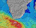 | 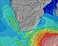 | 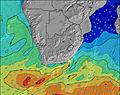 | ||||||||||||
Wave Height (m) Direction Period (s) | SSE 9 | SSE 9 | SSE 9 | SSW 14 | SSE 9 | SSE 9 | SE 9 | SE 9 | SE 10 | SE 11 | SE 11 | SE 11 | ESE 10 | ESE 10 | ESE 10 | ESE 9 | ESE 9 | ESE 9 | ESE 9 |
Wave Graph | |||||||||||||||||||
453 | 692 | 929 | 1606 | 1393 | 969 | 734 | 699 | 842 | 1565 | 1732 | 1363 | 794 | 661 | 555 | 355 | 271 | 180 | 121 | |
Wind (km/h) | |||||||||||||||||||
Wind State on-shore cross-onshore cross-shore cross-offshore off-shore glassy | cross-off | cross-off | cross-off | cross-off | cross-off | cross-off | cross-off | cross-off | cross-off | off | cross-off | cross | cross-off | cross-on | cross-on | cross | cross-on | cross-on | cross |
High Tide | 4:14AM1.81m | 4:36PM1.91m | 4:43AM1.85m | 5:04PM1.95m | 5:11AM1.85m | 5:33PM1.96m | 5:40AM1.84m | 6:02PM1.94m | 6:10AM1.79m | 6:34PM1.88m | 6:42AM1.71m | 7:10PM1.78m | |||||||
Low Tide | 10:13PM0.39m | 10:23AM0.27m | 10:43PM0.34m | 10:50AM0.23m | 11:12PM0.31m | 11:18AM0.21m | 11:41PM0.32m | 11:47AM0.23m | 00:11AM0.36m | 12:17PM0.28m | 00:44AM0.43m | 12:50PM0.37m | 1:21AM0.53m | ||||||
— | 6:41 | — | — | 6:41 | — | — | 6:41 | — | — | 6:39 | — | — | 6:39 | — | — | 6:39 | — | — | |
5:21 | — | 5:21 | — | — | 5:22 | — | — | 5:22 | — | — | 5:22 | — | — | 5:23 | — | — | 5:23 | — | |
mm | 6 | — | — | — | — | — | — | — | — | — | — | — | — | — | — | — | — | — | — |
Temp °C | 15 | 18 | 19 | 17 | 18 | 19 | 17 | 17 | 18 | 16 | 20 | 20 | 18 | 20 | 21 | 19 | 21 | 21 | 20 |
Feels °C | 11 | 11 | 11 | 10 | 11 | 12 | 12 | 13 | 13 | 12 | 18 | 18 | 19 | 17 | 18 | 18 | 17 | 17 | 20 |
Swell 1 Height (m) Direction Period (s) | SSE 9 | E 9 | SSW 14 | SSE 9 | SSE 9 | SSW 16 | SE 9 | SE 9 | SE 10 | SE 11 | SE 11 | SE 11 | ESE 10 | ESE 10 | ESE 10 | ESE 9 | ESE 9 | ESE 9 | ENE 7 |
453 | 60 | 154 | 999 | 1020 | 52 | 734 | 699 | 842 | 1565 | 1732 | 1363 | 794 | 661 | 555 | 355 | 271 | 180 | 158 | |
Swell 2 Height (m) Direction Period (s) | E 9 | SSW 15 | E 10 | SSW 14 | SSW 14 | SSW 13 | SSW 13 | SW 12 | ESE 12 | SSW 12 | SSW 11 | S 11 | S 10 | S 10 | S 10 | SSW 15 | SSW 13 | SSW 13 | ESE 9 |
108 | 174 | 71 | 113 | 73 | 33 | 16 | 5 | 314 | 15 | 23 | 20 | 17 | 17 | 17 | 21 | 17 | 16 | 121 | |
Swell 3 Height (m) Direction Period (s) | S 15 | — | — | — | — | — | SSW 16 | S 15 | SW 14 | — | S 18 | S 14 | S 13 | S 14 | SSW 16 | S 10 | S 11 | S 12 | SW 12 |
121 | — | — | — | — | — | 24 | 4 | 7 | — | 6 | 14 | 13 | 4 | 25 | 8 | 2 | 3 | 6 | |
Wind waves Height (m) Direction Period (s) | SW 5 | SSE 9 | SSE 9 | SSW 14 | SSE 9 | SSE 9 | — | — | — | WSW 3 | — | — | — | NNE 3 | — | NE 5 | ENE 5 | ENE 6 | NE 7 |
73 | 692 | 929 | 1606 | 1393 | 969 | — | — | — | 4 | — | — | — | 3 | — | 33 | 36 | 45 | 287 | |
Nearest Offshore or Glassy | |||||||||||||||||||
Distance (km) | 3 | 328 | 403 | 46 | 236 | 907 | 3 | 3 | 137 | 0 | 0 | 3 | 0 | 1 | 1 | 1 | 1 | 1 | 1 |
Best forecast wave conditions in Durban/KwaZulu-Natal South Coast | |||||||||||||||||||
Best forecast wave conditions in South Africa | |||||||||||||||||||
Header Global | |||||||||||||||||||
- Map Icons:
 Break
Break Live Wave Height (m)
 Live Wind Speed (km/h)
 Surf Rating (10 Max)
 Ocean Swells (m)
- Wind Speed (km/h)


FREE! Surf-Forecast.com widget for your website
The surf report / weather widget below is available to embed on third party websites free of charge and provides a summary of our Brighton Beach surf forecast. Simply grab the html code snippet that we provide and paste it into your own site. You can choose your preferred language and metric/imperial units for the surf forecast feed to suit users of your site. Click here to get the code.
Information about the Brighton Beach Surf forecast
The above surf forecast table for Brighton Beach provides essential information for determining whether the surfing conditions will be good over the next 16 days. A general guide to surfing at Brighton Beach can be found by selecting the local surf guide option on the grey menu. Our Brighton Beach surf forecast is unique since it includes wave energy (power) that defines the real feel of the surf rather than just the height or the period. If you surf the same spot (Brighton Beach) regularly then make a mental note of the wave energy from the surf forecast table each time you go. Very soon you may start to choose your surf days based on the wave energy alone combined with our forecast of favourable offshore wind conditions. Our star ratings will help here and of course you will also find the usual wave height and period predictions on our surf forecasts as well as a full break down of the swell components under our advanced users option (to reveal that, click the little Einstein character under the tide times).
Further information to help with frequently asked questions about our surf forecast for Brighton Beach may be found under the help tab on the top menu and also by moving your mouse over the question marks on the surf forecast table itself. Please always bear in mind that the forecast is for near-shore open water and local factors at each surf break influence the actual breaking wave height, such as the beach / reef profile, water depths offshore and shelter.
Are you planning a holiday in Durban/KwaZulu-Natal South Coast? If you are looking for accommodation near Brighton Beach, camping, hotels and holiday cottages in Durban/KwaZulu-Natal South Coast, consider staying in Durban which is 6 km (4 miles) away. Other places in and around Durban/KwaZulu-Natal South Coast where you can find information about places to rent, and car hire include Glenwood which is 8 km (5 miles) away, Kwamashu, Umhlanga and Mount Edgecombe.
 Nearest