

Surf Forecasts:
Aoshima surf forecast from 3 Aug 2026:
- Best quality surf: Wednesday 5 Aug, 3PM (local time) - 16ft (5.0m), 18s period, ESE swell with cross-onshore winds.
- Most powerful swell: Friday 7 Aug, 12AM (local time) - 26ft (8.0m), 17s period, SE swell with 40,237 kJ wave energy.
- Next surfable swell (1★+): Wednesday 5 Aug, 3PM (local time) - 16ft (5.0m), 18s period with ESE swell.
Best Forecast Surf Conditions for Aoshima this week:
The surf forecast for Aoshima over the next 16 days: The first swell (rated 1 star or higher) is forecast to arrive on Wednesday (Aug 05) at 3PM. The primary swell is predicted to be 5.0m and 18s period. The wind is predicted to be cross-onshore as the swell arrives.
The most powerful waves expected at Aoshima in the next 16 days are 8.0m 17s and forecast to arrive on Friday (Aug 07) at 12AM. Winds are predicted to be onshore at the time the swell arrives.
| Wave Type | Time (JST) & Date | Wave Height & Period |
|---|---|---|
| Next good surf (1 star+) | 3PM (Wed 5th Aug) | 16ft (5.0m) 18s |
| Best Surf | 3PM (Wed 5th Aug) | 16ft (5.0m) 18s |
| Most Powerful | 12AM (Fri 7th Aug) | 26ft (8.0m) 17s |
Table - best surf conditions forecast for Aoshima over the next 16 days.
The Lowdown
Gather 'round, crew. Let's talk about Aoshima. This is a reef break that's exposed to the open ocean, so when the swell hits, it hits. But the forecast for the next 16 days is a wild ride, and honestly, not a whole lot of it is for the faint of heart. The water is sitting at a warm 85°, which is about average for this time of year, so no wetsuit worries there.
We've got a long stretch of big, angry surf ahead. The first real shout comes on Monday, August 3rd, but it's a tough one. You've got a 5 ft ESE groundswell with a long 16-second period, packing moderate energy (1073). But the wind is a cross-onshore breeze at 12 mph, making it choppy and messy. Not a great day to paddle out, honestly. The afternoon sees the swell bump to 6 ft, but the wind turns onshore, so it's still a write-off.
Tuesday, the 4th, is a no-go for most. The swell jumps to 8 ft and then 10 ft with a massive 17-second period from the ESE. The wind is still onshore, and the energy is huge (4351 in the morning, 5534 in the afternoon). That's expert territory, and with the wind ruining it, it's a pass.
Wednesday, August 5th, is where things get stupid. The swell is 15 ft in the morning, hitting 16 ft in the afternoon with an 18-second period. The combined energy is absolutely insane – 11,066 in the morning, 15,282 in the afternoon. The wind is a fresh cross-onshore, making it lumpy. This is not for paddle surfing. Honestly, this kind of setup looks more interesting for kite surfing than paddle surfing. The swell is too big for the break, even if the wind and tide are favorable on paper.
Thursday through Sunday, the 6th to the 9th, are a write-off. We're looking at 23 ft to 25 ft swells on Thursday and Friday, with near gale-force onshore winds. The energy numbers are in the stratosphere – 29,334, 37,106, 58,330. It's just a dangerous, blown-out mess. The swell drops a bit over the weekend, but the wind stays strong and onshore, keeping the conditions poor.
The following week, from Monday the 10th through to Saturday the 16th, is a long, bleak stretch. The swell stays between 3 ft and 10 ft, but the wind is either onshore or strong cross-onshore, with near-constant "risk tstorm" conditions. The energy is low to moderate, but the quality is just not there. It's a 7-day gap of nothing but frustration.
Now, here's the light at the end of the tunnel. On Monday, August 17th, we get a glimmer of hope. The swell is still big at 16 ft from the E with a 13-second period, and the energy is massive (14,367). But the wind is a gentle cross-onshore, which is a huge improvement. The skies are clear. It's still a massive, powerful wave (over 8 ft, so experts only), and the period is long, so at a reef break like Aoshima, it could be a proper groundswell session. It's a standout for the sheer power and potential, but it's a long way off, so take that promise with a grain of salt.
Tuesday, August 18th, is your best bet. The swell drops to a more manageable 12 ft from the E, still with a 12-second period. The energy is moderate (3783). The key here is the wind – it's a slight air, barely a cross-onshore breeze, with just small wind ripples. This is the cleanest window in the whole forecast. The swell is still big (over 8 ft, experts only), but the conditions are finally right. It's a late call, but if you're an expert and you can wait, this is the one to pencil in. The crowd factor is "sometimes," so there's a chance you'll have some company, but with this much swell, it'll be a select crew.
So, to wrap it up: most of the next two weeks is either too big, too windy, or both. Your only real shout is the 18th, and maybe a long-shot look at the 17th if you're a big-wave charger. It's a tough forecast for Aoshima.
Rusty.
Short Range ForecastHeavy rain (total 37mm), heaviest during Mon night. Warm (max 30°C on Mon morning, min 27°C on Mon night). Winds increasing (light winds from the NE on Mon night, strong winds from the NE by Wed night). | Days 4-6 Weather SummaryHeavy rain (total 113mm), heaviest during Thu night. Warm (max 28°C on Thu morning, min 27°C on Thu morning). Mainly near gales. | ||||||||||||||||||||
Monday 3 | Tuesday 4 | Wednesday 5 | Thursday 6 | Friday 7 | Saturday 8 | Sunday 9 | |||||||||||||||
AM | PM | Night | AM | PM | Night | AM | PM | Night | AM | PM | Night | AM | PM | Night | AM | PM | Night | AM | PM | Night | |
Swell Height Map |  |  |  | 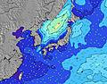 | 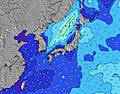 | 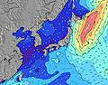 | 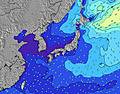 | ||||||||||||||
Wave Height (m) Direction Period (s) | ESE 16 | ESE 16 | ESE 17 | E 17 | ESE 17 | ESE 17 | ESE 17 | ESE 18 | ESE 17 | ESE 18 | ESE 17 | SE 17 | SSE 16 | SE 16 | SSE 16 | SSE 14 | SSE 14 | SSE 14 | ESE 10 | ESE 10 | ESE 9 |
Wave Graph | |||||||||||||||||||||
1038 | 1428 | 2171 | 4066 | 5087 | 6449 | 11066 | 15282 | 20762 | 29334 | 32918 | 40237 | 29781 | 14361 | 9803 | 5858 | 4720 | 3119 | 2040 | 2710 | 2296 | |
Wind (km/h) | |||||||||||||||||||||
Wind State on-shore cross-onshore cross-shore cross-offshore off-shore glassy | cross-on | on | cross-on | cross-on | on | on | cross-on | cross-on | cross-on | cross-on | on | on | on | on | on | on | on | cross-on | on | on | cross-on |
High Tide | 9:20PM2.04m | 9:43AM1.82m | 9:51PM1.98m | 10:45AM1.67m | 10:27PM1.91m | 12:18PM1.56m | 11:14PM1.84m | 2:34PM1.58m | 00:24AM1.79m | 4:09PM1.71m | 1:55AM1.79m | 4:58PM1.85m | |||||||||
Low Tide | 3:02PM0.65m | 3:38AM0.72m | 3:36PM0.86m | 4:29AM0.72m | 4:14PM1.07m | 5:33AM0.72m | 5:04PM1.28m | 6:56AM0.70m | 6:41PM1.44m | 8:23AM0.61m | 8:51PM1.47m | 9:33AM0.47m | 10:08PM1.38m | ||||||||
5:30 | — | — | 5:31 | — | — | 5:31 | — | — | 5:31 | — | — | 5:33 | — | — | 5:33 | — | — | 5:33 | — | — | |
— | 7:08 | — | — | 7:08 | — | — | 7:07 | — | — | 7:07 | — | — | 7:06 | — | — | 7:05 | — | — | 7:04 | — | |
mm | — | 2 | 13 | 3 | 5 | 4 | 3 | 1 | 6 | 7 | 4 | 19 | 8 | 9 | 22 | 12 | 10 | 22 | 12 | 10 | 19 |
Temp °C | 30 | 30 | 28 | 28 | 29 | 28 | 28 | 28 | 28 | 28 | 28 | 28 | 28 | 28 | 28 | 28 | 28 | 28 | 27 | 28 | 27 |
Feels °C | 32 | 32 | 32 | 30 | 32 | 31 | 28 | 27 | 27 | 25 | 25 | 25 | 25 | 26 | 26 | 26 | 27 | 27 | 25 | 26 | 25 |
Swell 1 Height (m) Direction Period (s) | ESE 16 | ESE 16 | ESE 17 | E 17 | ESE 17 | ESE 17 | ESE 17 | ESE 18 | ESE 17 | ESE 18 | ESE 17 | SE 17 | SSE 16 | SE 16 | SSE 16 | SSE 14 | SSE 14 | SSE 14 | SSE 13 | S 12 | S 11 |
1038 | 1428 | 2171 | 4066 | 5087 | 6449 | 11066 | 15282 | 20762 | 29334 | 32918 | 40237 | 28549 | 14361 | 9803 | 5858 | 4720 | 3119 | 1893 | 1254 | 746 | |
Swell 2 Height (m) Direction Period (s) | ENE 14 | ENE 15 | ENE 6 | — | — | — | — | — | — | — | — | — | — | — | — | — | — | — | — | — | S 16 |
21 | 42 | 64 | — | — | — | — | — | — | — | — | — | — | — | — | — | — | — | — | — | 192 | |
Swell 3 Height (m) Direction Period (s) | SSE 10 | S 7 | — | — | — | — | — | — | — | — | — | — | — | — | — | — | — | — | — | — | — |
9 | 4 | — | — | — | — | — | — | — | — | — | — | — | — | — | — | — | — | — | — | — | |
Wind waves Height (m) Direction Period (s) | SSE 7 | NE 4 | ENE 6 | E 7 | E 8 | — | — | — | — | — | ENE 10 | ESE 17 | ESE 16 | E 12 | ESE 11 | ESE 10 | ESE 10 | ESE 9 | ESE 10 | ESE 10 | ESE 9 |
5 | 14 | 115 | 285 | 447 | — | — | — | — | — | 4188 | 38901 | 29781 | 7557 | 6448 | 4125 | 2947 | 2133 | 2040 | 2710 | 2296 | |
Nearest Offshore or Glassy | |||||||||||||||||||||
Distance (km) | 50 | 50 | 38 | 50 | 50 | 50 | 288 | 842 | 288 | 837 | 1382 | 791 | 1467 | 791 | 339 | 674 | 791 | 791 | 1740 | 1382 | 283 |
Best forecast wave conditions in Kyu Shu | |||||||||||||||||||||
Best forecast wave conditions in Japan | |||||||||||||||||||||
Header Global | |||||||||||||||||||||
- Map Icons:
 Break
Break Live Wave Height (m)
 Live Wind Speed (km/h)
 Surf Rating (10 Max)
 Ocean Swells (m)
- Wind Speed (km/h)
Latest Updates


FREE! Surf-Forecast.com widget for your website
The surf report / weather widget below is available to embed on third party websites free of charge and provides a summary of our Aoshima surf forecast. Simply grab the html code snippet that we provide and paste it into your own site. You can choose your preferred language and metric/imperial units for the surf forecast feed to suit users of your site. Click here to get the code.
Information about the Aoshima Surf forecast
The above surf forecast table for Aoshima provides essential information for determining whether the surfing conditions will be good over the next 16 days. A general guide to surfing at Aoshima can be found by selecting the local surf guide option on the grey menu. Our Aoshima surf forecast is unique since it includes wave energy (power) that defines the real feel of the surf rather than just the height or the period. If you surf the same spot (Aoshima) regularly then make a mental note of the wave energy from the surf forecast table each time you go. Very soon you may start to choose your surf days based on the wave energy alone combined with our forecast of favourable offshore wind conditions. Our star ratings will help here and of course you will also find the usual wave height and period predictions on our surf forecasts as well as a full break down of the swell components under our advanced users option (to reveal that, click the little Einstein character under the tide times).
Further information to help with frequently asked questions about our surf forecast for Aoshima may be found under the help tab on the top menu and also by moving your mouse over the question marks on the surf forecast table itself. Please always bear in mind that the forecast is for near-shore open water and local factors at each surf break influence the actual breaking wave height, such as the beach / reef profile, water depths offshore and shelter.
Aoshima is 14 km (9 miles) from Miyazaki-shi. If you plan a holiday in Kyu Shu, look for hotels and other accommodation in Miyazaki-shi. Miyazaki-shi has rooms for a wide range of budgets as well as car hire and transport links.
 Nearest