

Surf Forecasts:

How big are the waves at Westport-The Groins today (02 Aug):
- Morning surf: Morning surf (02 Aug, local time) - 5ft (1.5m), 8s period with W swell.
- Afternoon surf: Afternoon surf (02 Aug, local time) - 5ft (1.6m), 9s period with W swell.
- Evening surf: Evening surf (02 Aug, local time) - 5ft (1.6m), 9s period with WNW swell.
The current surf forecast for Westport-The Groins at 7PM is: 1.6m 9s primary swell from a West-northwest direction and 0.4m 14s secondary swell from a Southwest direction, 0.1m 19s secondary swell from a Southwest direction (forecast issued at 10:00am August 02). The wind direction is predicted to be cross-onshore.
| Time (PDT) & Date | Wave Height | Wave Period |
|---|---|---|
| Morning (02 Aug) | 5ft (1.5m) | 8s |
| Afternoon (02 Aug) | 5ft (1.6m) | 9s |
| Evening (02 Aug) | 5ft (1.6m) | 9s |
Table - waves today at Westport-The Groins. (Swell directed towards the surf break)
Short Range ForecastMostly dry. Warm (max 22°C on Tue afternoon, min 12°C on Mon morning). Winds decreasing (fresh winds from the NW on Sun afternoon, calm by Mon morning). | ||||||||||||||||||||||
Sunday 2 | Monday 3 | Tuesday 4 | ||||||||||||||||||||
8 AM | 11 AM | 2 PM | 5 PM | 8 PM | 11 PM | 2 AM | 5 AM | 8 AM | 11 AM | 2 PM | 5 PM | 8 PM | 11 PM | 2 AM | 5 AM | 8 AM | 11 AM | 2 PM | 5 PM | 8 PM | 11 PM | |
Swell Height Map |  | 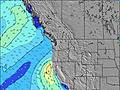 | 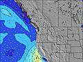 | 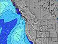 | 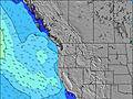 | 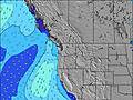 | 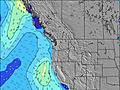 | 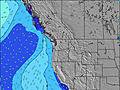 | ||||||||||||||
Wave Height (m) Direction Period (s) | W 8 | W 9 | W 9 | W 9 | WNW 9 | WNW 8 | WNW 8 | W 8 | W 7 | WNW 7 | WNW 7 | WNW 7 | WNW 7 | WNW 7 | WNW 6 | SW 16 | WNW 7 | WNW 7 | WNW 7 | WNW 7 | NW 7 | WNW 8 |
Wave Graph | ||||||||||||||||||||||
313 | 334 | 351 | 412 | 417 | 338 | 229 | 181 | 134 | 136 | 136 | 135 | 120 | 116 | 104 | 79 | 102 | 111 | 118 | 111 | 122 | 217 | |
Wind (km/h) | ||||||||||||||||||||||
Wind State on-shore cross-onshore cross-shore cross-offshore off-shore glassy | glassy | cross-on | cross-on | cross-on | cross-on | cross-on | on | cross-on | cross | glassy | cross-on | cross-on | cross-on | on | on | cross-on | cross-on | on | cross-on | cross-on | cross-on | on |
High Tide | 4:18PM2.49m | 4:10AM2.25m | 4:50PM2.54m | 5:01AM2.05m | 5:25PM2.58m | |||||||||||||||||
Low Tide | 9:36AM-0.07m | 10:07PM0.45m | 10:08AM0.12m | 10:55PM0.36m | 10:42AM0.37m | |||||||||||||||||
5:56 | — | — | — | — | — | — | 5:58 | — | — | — | — | — | — | — | 5:58 | — | — | — | — | — | — | |
— | — | — | — | 8:46 | — | — | — | — | — | — | — | 8:45 | — | — | — | — | — | — | — | 8:44 | — | |
mm | — | — | — | — | — | — | — | — | — | — | — | — | — | — | — | — | — | — | — | — | — | — |
Temp °C | 14 | 15 | 15 | 15 | 14 | 14 | 13 | 13 | 12 | 16 | 18 | 18 | 16 | 15 | 15 | 15 | 15 | 21 | 22 | 20 | 17 | 16 |
Feels °C | 14 | 13 | 10 | 10 | 9 | 10 | 11 | 12 | 10 | 15 | 14 | 13 | 12 | 12 | 13 | 13 | 13 | 19 | 18 | 15 | 13 | 14 |
Swell 1 Height (m) Direction Period (s) | W 8 | W 9 | SW 14 | SW 14 | SW 14 | SW 13 | WNW 8 | W 8 | W 7 | WNW 7 | SW 13 | SW 13 | SW 13 | SW 13 | WNW 6 | WNW 7 | WNW 7 | WNW 7 | WNW 10 | WNW 9 | W 9 | WNW 8 |
313 | 334 | 65 | 64 | 64 | 63 | 229 | 181 | 134 | 136 | 27 | 27 | 27 | 27 | 104 | 79 | 102 | 111 | 18 | 28 | 42 | 217 | |
Swell 2 Height (m) Direction Period (s) | SW 14 | SW 14 | SW 19 | SW 19 | SW 18 | WSW 18 | SW 13 | SW 13 | SW 13 | SW 13 | WSW 18 | WSW 18 | WSW 17 | WSW 16 | SW 16 | SW 16 | SW 16 | SW 16 | SW 16 | SW 16 | SW 16 | SW 16 |
97 | 68 | 15 | 15 | 13 | 31 | 63 | 46 | 45 | 28 | 30 | 30 | 29 | 26 | 66 | 66 | 66 | 66 | 66 | 65 | 64 | 62 | |
Swell 3 Height (m) Direction Period (s) | WSW 19 | WSW 19 | SW 19 | — | — | — | WSW 18 | SW 18 | SW 18 | SW 18 | — | — | — | — | SW 13 | SW 13 | SW 13 | WSW 13 | WSW 13 | SW 12 | SW 12 | SW 12 |
37 | 37 | 15 | — | — | — | 31 | 80 | 80 | 49 | — | — | — | — | 27 | 27 | 27 | 16 | 16 | 6 | 6 | 6 | |
Wind waves Height (m) Direction Period (s) | — | — | W 9 | W 9 | WNW 9 | WNW 8 | — | — | — | — | WNW 7 | WNW 7 | WNW 7 | WNW 7 | — | — | — | — | WNW 7 | WNW 7 | NW 7 | NW 7 |
— | — | 351 | 412 | 417 | 338 | — | — | — | — | 136 | 135 | 120 | 116 | — | — | — | — | 118 | 111 | 122 | 128 | |
Nearest Offshore or Glassy | ||||||||||||||||||||||
Distance (km) | 0 | 143 | 1009 | 1436 | 1009 | 140 | 3 | 3 | 1 | 0 | 51 | 165 | 658 | 165 | 6 | 3 | 3 | 3 | 51 | 165 | 159 | 159 |
Best forecast wave conditions in Washington State | ||||||||||||||||||||||
Best forecast wave conditions in United States | ||||||||||||||||||||||
Header Global | ||||||||||||||||||||||
- Map Icons:
 Break
Break Live Wave Height (m)
 Live Wind Speed (km/h)
 Surf Rating (10 Max)
 Ocean Swells (m)
- Wind Speed (km/h)
Latest Updates


FREE! Surf-Forecast.com widget for your website
The surf report / weather widget below is available to embed on third party websites free of charge and provides a summary of our Westport-The Groins surf forecast. Simply grab the html code snippet that we provide and paste it into your own site. You can choose your preferred language and metric/imperial units for the surf forecast feed to suit users of your site. Click here to get the code.
 Nearest