

Surf Forecasts:

How big are the waves at Trayhan's today (03 Aug):
- Morning surf: Morning surf (03 Aug, local time) - 2.5ft (0.7m), 5s period with SSE swell.
- Afternoon surf: Afternoon surf (03 Aug, local time) - 5ft (1.5m), 6s period with S swell.
- Evening surf: Evening surf (03 Aug, local time) - 7ft (2.1m), 8s period with S swell.
The current surf forecast for Trayhan's at 12PM is: 1.1m 6s primary swell from a South-southeast direction and 0.1m 9s secondary swell from a Southeast direction (forecast issued at 07:00am August 03). The wind direction is predicted to be cross-shore.
| Time (EDT) & Date | Wave Height | Wave Period |
|---|---|---|
| Morning (03 Aug) | 2.5ft (0.7m) | 5s |
| Afternoon (03 Aug) | 5ft (1.5m) | 6s |
| Evening (03 Aug) | 7ft (2.1m) | 8s |
Table - waves today at Trayhan's. (Swell directed towards the surf break)
Short Range ForecastHeavy rain (total 24mm), heaviest during Mon night. Warm (max 27°C on Tue afternoon, min 18°C on Mon night). Winds decreasing (strong winds from the SSW on Mon afternoon, calm by Wed morning). | |||||||||||||||||||||||
Monday 3 | Tuesday 4 | Wednesday 5 | |||||||||||||||||||||
5 AM | 8 AM | 11 AM | 2 PM | 5 PM | 8 PM | 11 PM | 2 AM | 5 AM | 8 AM | 11 AM | 2 PM | 5 PM | 8 PM | 11 PM | 2 AM | 5 AM | 8 AM | 11 AM | 2 PM | 5 PM | 8 PM | 11 PM | |
Swell Height Map | 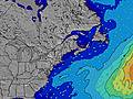 | 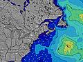 | 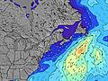 | 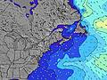 | 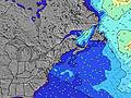 | 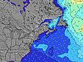 | 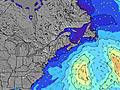 | 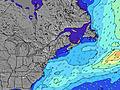 | 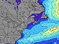 | ||||||||||||||
Wave Height (m) Direction Period (s) | SSE 5 | SSE 5 | S 5 | SSE 6 | S 7 | S 8 | S 8 | S 8 | S 8 | S 8 | S 8 | S 8 | SSE 8 | S 5 | S 5 | SSE 6 | S 5 | SSE 7 | SSE 7 | SSE 7 | SSE 7 | SSE 7 | SSE 7 |
Wave Graph | |||||||||||||||||||||||
26 | 18 | 55 | 130 | 338 | 579 | 443 | 264 | 191 | 136 | 84 | 78 | 45 | 40 | 67 | 31 | 21 | 16 | 36 | 26 | 26 | 18 | 17 | |
Wind (km/h) | |||||||||||||||||||||||
Wind State on-shore cross-onshore cross-shore cross-offshore off-shore glassy | cross-on | cross-on | cross-on | cross | cross | cross-off | off | cross-off | cross-off | cross-off | cross-off | cross | cross | cross | glassy | cross-off | glassy | glassy | cross-on | cross-on | cross-on | on | cross |
High Tide | 2:27AM2.83m | 2:53PM2.83m | 3:11AM2.76m | 3:36PM2.89m | 4:01AM2.68m | 4:24PM2.92m | |||||||||||||||||
Low Tide | 8:36AM0.05m | 8:59PM0.14m | 9:17AM0.09m | 9:49PM0.12m | 10:04AM0.16m | 10:44PM0.12m | |||||||||||||||||
5:30 | — | — | — | — | — | — | — | 5:31 | — | — | — | — | — | — | — | 5:31 | — | — | — | — | — | — | |
— | — | — | — | — | 8:00 | — | — | — | — | — | — | 7:59 | — | — | — | — | — | — | — | 7:58 | — | — | |
mm | 1 | 6 | 6 | 3 | 2 | 7 | — | — | — | — | — | — | — | — | — | — | — | — | — | — | — | — | — |
Temp °C | 19 | 20 | 20 | 20 | 21 | 22 | 20 | 18 | 18 | 19 | 24 | 26 | 27 | 25 | 26 | 23 | 22 | 21 | 22 | 23 | 22 | 22 | 20 |
Feels °C | 20 | 20 | 18 | 18 | 16 | 20 | 16 | 16 | 14 | 16 | 20 | 22 | 23 | 21 | 25 | 21 | 21 | 21 | 21 | 22 | 24 | 24 | 22 |
Swell 1 Height (m) Direction Period (s) | SSE 5 | SSE 7 | SE 9 | — | — | — | S 8 | S 8 | S 8 | S 8 | S 8 | — | SSE 8 | SSE 8 | S 5 | SSE 6 | S 5 | S 5 | SSE 7 | SSE 7 | SSE 7 | SSE 7 | SSE 7 |
26 | 9 | 3 | — | — | — | 443 | 264 | 191 | 136 | 84 | — | 45 | 20 | 34 | 31 | 21 | 15 | 36 | 26 | 26 | 18 | 17 | |
Swell 2 Height (m) Direction Period (s) | SSE 7 | S 7 | — | — | — | — | — | — | — | — | — | — | — | E 12 | SSE 8 | SSE 8 | SSE 7 | SSE 7 | — | — | — | S 9 | S 9 |
9 | 4 | — | — | — | — | — | — | — | — | — | — | — | 3 | 19 | 12 | 16 | 16 | — | — | — | 1 | 2 | |
Swell 3 Height (m) Direction Period (s) | S 7 | SE 9 | — | — | — | — | — | — | — | — | — | — | — | — | — | S 8 | — | — | — | — | — | — | — |
1 | 3 | — | — | — | — | — | — | — | — | — | — | — | — | — | 10 | — | — | — | — | — | — | — | |
Wind waves Height (m) Direction Period (s) | — | SSE 5 | S 5 | SSE 6 | S 7 | S 8 | — | W 4 | WSW 4 | WSW 4 | SW 4 | S 8 | S 4 | S 5 | S 5 | — | — | — | — | — | — | — | — |
— | 18 | 55 | 130 | 338 | 579 | — | 9 | 17 | 7 | 8 | 78 | 20 | 40 | 67 | — | — | — | — | — | — | — | — | |
Nearest Offshore or Glassy | |||||||||||||||||||||||
Distance (km) | 2085 | 719 | 698 | 493 | 476 | 166 | 73 | 73 | 73 | 73 | 73 | 306 | 110 | 306 | 73 | 73 | 274 | 265 | 265 | 197 | 195 | 202 | 276 |
Best forecast wave conditions in Maine | |||||||||||||||||||||||
Best forecast wave conditions in United States | |||||||||||||||||||||||
Header Global | |||||||||||||||||||||||
- Map Icons:
 Break
Break Live Wave Height (m)
 Live Wind Speed (km/h)
 Surf Rating (10 Max)
 Ocean Swells (m)
- Wind Speed (km/h)
Latest Updates


FREE! Surf-Forecast.com widget for your website
The surf report / weather widget below is available to embed on third party websites free of charge and provides a summary of our Trayhan's surf forecast. Simply grab the html code snippet that we provide and paste it into your own site. You can choose your preferred language and metric/imperial units for the surf forecast feed to suit users of your site. Click here to get the code.
 Nearest