

Surf Forecasts:

How big are the waves at Sodwana today (03 Aug):
- Morning surf: Morning surf (03 Aug, local time) - 8ft (2.4m), 11s period with SSE swell.
- Afternoon surf: Afternoon surf (03 Aug, local time) - 7ft (2.1m), 10s period with SE swell.
- Evening surf: Evening surf (03 Aug, local time) - 6ft (1.9m), 10s period with SE swell.
The current surf forecast for Sodwana at 7AM is: 2.5m 11s primary swell from a South-southeast direction and 0.2m 14s secondary swell from a South direction (forecast issued at 01:00am August 03). The wind direction is predicted to be cross-shore.
| Time (SAST) & Date | Wave Height | Wave Period |
|---|---|---|
| Morning (03 Aug) | 8ft (2.4m) | 11s |
| Afternoon (03 Aug) | 7ft (2.1m) | 10s |
| Evening (03 Aug) | 6ft (1.9m) | 10s |
Table - waves today at Sodwana. (Swell directed towards the surf break)
Short Range ForecastMostly dry. Warm (max 25°C on Wed afternoon, min 18°C on Mon morning). Wind will be generally light. | ||||||||||||||||||||||||
Monday 3 | Tuesday 4 | Wednesday 5 | ||||||||||||||||||||||
2 AM | 5 AM | 8 AM | 11 AM | 2 PM | 5 PM | 8 PM | 11 PM | 2 AM | 5 AM | 8 AM | 11 AM | 2 PM | 5 PM | 8 PM | 11 PM | 2 AM | 5 AM | 8 AM | 11 AM | 2 PM | 5 PM | 8 PM | 11 PM | |
Swell Height Map |  |  |  |  | 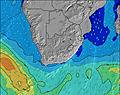 |  |  | 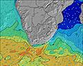 |  | |||||||||||||||
Wave Height (m) Direction Period (s) | SSE 11 | SSE 11 | SSE 11 | SE 11 | SE 11 | SE 10 | SE 10 | SE 10 | SE 10 | SE 10 | SE 10 | SE 10 | SE 10 | SE 10 | SE 10 | SE 10 | ESE 10 | ESE 10 | ESE 10 | ESE 10 | ESE 10 | ESE 9 | ESE 9 | ESE 9 |
Wave Graph | ||||||||||||||||||||||||
2023 | 1686 | 1421 | 1212 | 1009 | 816 | 724 | 653 | 557 | 530 | 562 | 508 | 450 | 388 | 246 | 185 | 141 | 231 | 231 | 214 | 175 | 156 | 156 | 156 | |
Wind (km/h) | ||||||||||||||||||||||||
Wind State on-shore cross-onshore cross-shore cross-offshore off-shore glassy | cross-off | cross | cross | cross-on | on | on | on | glassy | cross-off | cross-off | glassy | cross | cross | cross | cross | cross-off | cross-off | cross-off | cross-off | cross-off | cross-off | cross | cross-off | cross-off |
High Tide | 6:10AM1.99m | 6:32PM2.04m | 6:41AM1.89m | 7:06PM1.93m | 7:17AM1.75m | 7:47PM1.78m | ||||||||||||||||||
Low Tide | 00:07AM0.21m | 12:17PM0.15m | 00:40AM0.29m | 12:50PM0.25m | 1:17AM0.40m | 1:28PM0.38m | ||||||||||||||||||
— | 6:28 | — | — | — | — | — | — | — | 6:26 | — | — | — | — | — | — | — | 6:26 | — | — | — | — | — | — | |
— | — | — | — | — | 5:21 | — | — | — | — | — | — | — | 5:22 | — | — | — | — | — | — | — | 5:22 | — | — | |
mm | — | — | — | — | — | — | — | — | — | — | — | — | — | — | — | — | — | — | — | — | — | — | — | — |
Temp °C | 17 | 17 | 18 | 22 | 23 | 21 | 21 | 20 | 20 | 19 | 18 | 21 | 22 | 21 | 21 | 20 | 19 | 19 | 18 | 23 | 25 | 21 | 21 | 21 |
Feels °C | 15 | 15 | 16 | 20 | 21 | 20 | 21 | 21 | 21 | 20 | 19 | 22 | 21 | 20 | 20 | 20 | 19 | 19 | 17 | 20 | 21 | 18 | 20 | 20 |
Swell 1 Height (m) Direction Period (s) | SSE 11 | SSE 11 | SSE 11 | SE 11 | SE 11 | SE 10 | SE 10 | SE 10 | SE 10 | SE 10 | SE 10 | SE 10 | SE 10 | SE 10 | SE 10 | SE 10 | ESE 10 | ESE 10 | ESE 10 | ESE 10 | ESE 10 | ESE 9 | ESE 9 | ESE 9 |
2023 | 1686 | 1421 | 1212 | 1009 | 816 | 724 | 653 | 557 | 530 | 562 | 508 | 450 | 388 | 246 | 185 | 141 | 231 | 231 | 214 | 175 | 156 | 156 | 156 | |
Swell 2 Height (m) Direction Period (s) | S 18 | S 15 | S 14 | S 13 | S 18 | S 14 | S 15 | S 14 | S 10 | S 10 | S 10 | S 10 | S 12 | SSE 12 | ESE 10 | ESE 10 | SE 9 | SSE 11 | S 11 | S 11 | SE 11 | S 11 | S 11 | S 10 |
6 | 17 | 32 | 14 | 6 | 16 | 4 | 15 | 8 | 19 | 8 | 8 | 11 | 14 | 100 | 102 | 103 | 12 | 2 | 3 | 5 | 2 | 2 | 2 | |
Swell 3 Height (m) Direction Period (s) | — | S 17 | S 17 | S 17 | S 18 | S 17 | S 16 | S 16 | S 13 | S 15 | S 13 | S 15 | S 14 | S 13 | S 11 | S 11 | S 11 | S 12 | S 12 | S 10 | S 12 | S 12 | — | — |
— | 6 | 6 | 6 | 6 | 6 | 5 | 5 | 3 | 4 | 13 | 4 | 4 | 4 | 9 | 2 | 10 | 3 | 3 | 2 | 3 | 3 | — | — | |
Wind waves Height (m) Direction Period (s) | — | — | — | — | — | — | — | — | — | — | — | — | — | NE 2 | NE 3 | ENE 4 | NE 4 | NNE 4 | N 4 | NNE 4 | NNE 5 | NNE 5 | NE 5 | NE 5 |
— | — | — | — | — | — | — | — | — | — | — | — | — | 2 | 5 | 8 | 8 | 9 | 14 | 31 | 59 | 59 | 53 | 76 | |
Nearest Offshore or Glassy | ||||||||||||||||||||||||
Distance (km) | 233 | 152 | 152 | 118 | 356 | 204 | 204 | 0 | 0 | 0 | 0 | 148 | 356 | 356 | 247 | 0 | 0 | 0 | 233 | 204 | 356 | 356 | 233 | 233 |
Best forecast wave conditions in KwaZulu-Natal North Coast | ||||||||||||||||||||||||
Best forecast wave conditions in South Africa | ||||||||||||||||||||||||
Header Global | ||||||||||||||||||||||||
- Map Icons:
 Break
Break Live Wave Height (m)
 Live Wind Speed (km/h)
 Surf Rating (10 Max)
 Ocean Swells (m)
- Wind Speed (km/h)
Latest Updates


FREE! Surf-Forecast.com widget for your website
The surf report / weather widget below is available to embed on third party websites free of charge and provides a summary of our Sodwana surf forecast. Simply grab the html code snippet that we provide and paste it into your own site. You can choose your preferred language and metric/imperial units for the surf forecast feed to suit users of your site. Click here to get the code.
 Nearest