

Surf Forecasts:

Rancho Santini surf forecast from 3 Aug 2026:
- Best quality surf: Saturday 8 Aug, 11PM (local time) - 3ft (0.9m), 16s period, SSW swell with glassy winds.
- Most powerful swell: Saturday 8 Aug, 11PM (local time) - 3ft (0.9m), 16s period, SSW swell with 447 kJ wave energy.
- Next surfable swell (1★+): Monday 3 Aug, 11PM (local time) - 1.5ft (0.5m), 16s period with SW swell.
Best Forecast Surf Conditions for Rancho Santini this week:
The surf forecast for Rancho Santini over the next 16 days: The first swell (rated 1 star or higher) is forecast to arrive on Monday (Aug 03) at 11PM. The primary swell is predicted to be 0.5m and 16s period with a secondary swell of 0.7m and 9s. Another secondary swell of 0.5m and 12s is also forecast. The wind is predicted to be glassy as the swell arrives.
The most powerful waves expected at Rancho Santini in the next 16 days are 0.9m 16s and forecast to arrive on Saturday (Aug 08) at 11PM. Winds are predicted to be glassy at the time the swell arrives.
| Wave Type | Time (PDT) & Date | Wave Height & Period |
|---|---|---|
| Next good surf (1 star+) | 11PM (Mon 3rd Aug) | 1.5ft (0.5m) 16s |
| Best Surf | 11PM (Sat 8th Aug) | 3ft (0.9m) 16s |
| Most Powerful | 11PM (Sat 8th Aug) | 3ft (0.9m) 16s |
Table - best surf conditions forecast for Rancho Santini over the next 16 days.
The Lowdown
G’day, it’s Rusty here.
Honestly, the next couple of weeks are going to be a bit of a grind for surf around here. We’ve got a few pulses of swell coming through, but the quality is just not there for most of the window. You’re looking at a stretch where you’ll need to be patient, pick your moments, and not get too attached to any one session.
The water’s sitting at 71°, which is a touch warmer than normal for this time of year, so at least you won’t need a thick suit.
We start off on Monday, August 3rd, with some small, weak swell at Rancho Santini. The waves are only around 2ft to 2ft, with the energy pretty much all over the place – nothing substantial at all. The wind is offshore, but the size just isn’t there to make it worth your while. It’s a clean but flat sort of a day. This pattern holds through Thursday, with tiny 2ft to 2ft waves and light offshore winds. It’s all a bit frustrating, really.
Then, heading into Friday, August 7th, we finally see a bit of a pulse. The swell bumps up to 2ft and the period stretches out to 19 seconds, giving it some proper groundswell energy (509). It’s still small, but there’s finally a bit more push behind it. The wind is light and offshore in the morning, so the conditions are actually pretty clean. It’s still only a marginal call, but it’s the best we’ve seen. That trend continues into Saturday with 2ft to 3ft from the south-southwest, but the wind swings a little cross-on, which messes up the face a bit.
Sunday and Monday, August 9th and 10th, see the swell hang in there at around 3ft, but the period drops back down and it’s just not as clean. The cross-onshore wind creates a bit of texture on the surface, so it’s not really a stand-out. We get a slight bump again on Tuesday, August 11th, with 2ft and an 18-second period, but the overall energy is still pretty moderate.
The middle of the week, from Wednesday the 12th through to Friday the 14th, is more of the same – small, inconsistent surf with periods in that 16-18 second range. The wind stays offshore or light cross-on, but the waves are just not doing much. Then, we get a proper stint of wind starting on Thursday the 13th, picking up to 12 mph from the west-northwest. That’s going to chop things up and make it pretty messy.
Saturday, August 15th, sees the biggest swell of the window so far, hitting 3ft, but it comes with that moderate cross-onshore breeze, so it’s not going to be clean. We’ve got some energy there (569), but it’s not going to be well-shaped. That blustery, choppy condition carries through into Sunday the 16th with similar size and speed, and the wind gets even stronger in the afternoon. It’s not looking like a surf day.
Looking further out to Monday, August 17th, the wind settles back to light offshore, but the swell has dropped back to 2ft. It’s clean but pretty gutless.
Now, the one real glimmer of hope comes on Tuesday, August 18th. The swell is still small at 2ft, but the period is a solid 16 seconds, and crucially, we get a period of light rain showers and glassy conditions with almost no wind. That’s the standout window in the whole run. It’s the only time where the surf conditions actually look *good*. A tiny, clean little wave with some energy behind it – that’s about as good as it gets over this stretch.
So, overall, it’s a lean couple of weeks. There are no big standouts to get excited about. The best bet is that glassy window on Tuesday the 18th, and maybe a peek at Friday the 7th if you’re desperate. It’s not a total blank, but it’s certainly not a period for epic sessions.
Rusty.
Short Range ForecastMostly dry. Warm (max 27°C on Mon afternoon, min 21°C on Mon night). Wind will be generally light. | Days 4-6 Weather SummaryMostly dry. Warm (max 26°C on Thu afternoon, min 20°C on Fri night). Wind will be generally light. | ||||||||||||||||||||
Monday 3 | Tuesday 4 | Wednesday 5 | Thursday 6 | Friday 7 | Saturday 8 | Sunday 9 | |||||||||||||||
AM | PM | Night | AM | PM | Night | AM | PM | Night | AM | PM | Night | AM | PM | Night | AM | PM | Night | AM | PM | Night | |
Swell Height Map |  |  |  | 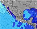 | 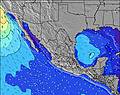 | 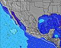 | 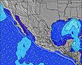 | ||||||||||||||
Wave Height (m) Direction Period (s) | SW 13 | SW 16 | SW 16 | SW 15 | SW 15 | SW 14 | SW 14 | SW 14 | SW 14 | SW 13 | SW 21 | SW 18 | SSW 19 | SSW 18 | SSW 18 | SW 16 | SSW 16 | SSW 16 | SSW 15 | SSW 15 | SSW 14 |
Wave Graph | |||||||||||||||||||||
82 | 127 | 125 | 112 | 107 | 169 | 128 | 125 | 189 | 109 | 138 | 157 | 329 | 218 | 390 | 278 | 326 | 397 | 272 | 272 | 261 | |
Wind (km/h) | |||||||||||||||||||||
Wind State on-shore cross-onshore cross-shore cross-offshore off-shore glassy | on | on | cross-on | on | on | cross-on | cross-on | on | cross-on | on | on | glassy | on | on | cross | cross-on | on | cross | cross-on | cross-on | glassy |
High Tide | 12:47PM1.79m | 00:36AM1.48m | 1:26PM1.84m | 1:51AM1.27m | 2:17PM1.88m | 4:07AM1.15m | 3:26PM1.94m | 6:41AM1.21m | 4:43PM2.03m | 7:44AM1.33m | 5:54PM2.16m | 8:22AM1.45m | 6:55PM2.29m | ||||||||
Low Tide | 7:03PM0.87m | 6:35AM0.75m | 8:22PM0.83m | 7:04AM0.90m | 10:04PM0.73m | 7:46AM1.05m | 11:38PM0.55m | 9:18AM1.17m | 00:45AM0.34m | 11:12AM1.19m | 1:36AM0.15m | 12:32PM1.11m | 2:21AM0.01m | ||||||||
6:03 | — | — | 6:03 | — | — | 6:05 | — | — | 6:05 | — | — | 6:05 | — | — | 6:07 | — | — | 6:07 | — | — | |
— | 7:43 | — | — | 7:42 | — | — | 7:40 | — | — | 7:40 | — | — | 7:39 | — | — | 7:38 | — | — | 7:37 | — | |
mm | — | — | — | — | — | — | — | — | — | — | — | — | — | — | — | — | — | — | — | — | — |
Temp °C | 26 | 27 | 21 | 25 | 25 | 21 | 24 | 25 | 22 | 25 | 26 | 23 | 25 | 25 | 22 | 25 | 26 | 22 | 26 | 26 | 22 |
Feels °C | 26 | 27 | 23 | 25 | 25 | 22 | 25 | 26 | 23 | 26 | 26 | 24 | 26 | 25 | 23 | 25 | 26 | 24 | 26 | 26 | 23 |
Swell 1 Height (m) Direction Period (s) | WNW 9 | SW 13 | W 9 | W 9 | SW 15 | SW 14 | SW 14 | SW 14 | SW 14 | SW 13 | SW 13 | SW 13 | SW 13 | SW 13 | SSW 18 | SW 16 | SSW 16 | SSW 16 | SSW 15 | SSW 15 | SSW 14 |
82 | 80 | 59 | 57 | 107 | 169 | 128 | 125 | 189 | 109 | 138 | 106 | 172 | 132 | 390 | 278 | 326 | 397 | 272 | 272 | 261 | |
Swell 2 Height (m) Direction Period (s) | SW 13 | SW 16 | SW 12 | SW 15 | SSW 13 | W 6 | W 5 | SW 12 | WNW 5 | WNW 5 | SW 21 | SW 18 | SSW 19 | SSW 18 | SW 12 | SSW 12 | SW 12 | SSW 12 | SSW 11 | SSW 11 | WNW 8 |
80 | 127 | 75 | 112 | 64 | 16 | 14 | 37 | 10 | 9 | 108 | 157 | 329 | 218 | 72 | 94 | 116 | 94 | 50 | 49 | 14 | |
Swell 3 Height (m) Direction Period (s) | SW 16 | SSW 11 | SW 16 | SW 12 | WNW 9 | S 11 | SSW 12 | S 9 | S 10 | S 11 | S 11 | WNW 5 | WNW 5 | WNW 5 | WNW 5 | W 5 | W 12 | WNW 5 | W 8 | SW 21 | SSW 11 |
67 | 23 | 125 | 77 | 8 | 9 | 56 | 6 | 8 | 23 | 9 | 9 | 8 | 9 | 5 | 4 | 12 | 2 | 11 | 72 | 24 | |
Wind waves Height (m) Direction Period (s) | — | WNW 9 | — | — | W 6 | — | — | W 5 | — | — | W 5 | — | — | — | — | — | — | — | — | S 7 | — |
— | 84 | — | — | 18 | — | — | 15 | — | — | 14 | — | — | — | — | — | — | — | — | 4 | — | |
Nearest Offshore or Glassy | |||||||||||||||||||||
Distance (km) | 57 | 9 | 9 | 9 | 9 | 9 | 57 | 9 | 9 | 57 | 9 | 0 | 223 | 223 | 11 | 78 | 793 | 11 | 78 | 11 | 0 |
Best forecast wave conditions in Baja Norte | |||||||||||||||||||||
Best forecast wave conditions in Mexico | |||||||||||||||||||||
Header Global | |||||||||||||||||||||
- Map Icons:
 Break
Break Live Wave Height (m)
 Live Wind Speed (km/h)
 Surf Rating (10 Max)
 Ocean Swells (m)
- Wind Speed (km/h)
Latest Updates


FREE! Surf-Forecast.com widget for your website
The surf report / weather widget below is available to embed on third party websites free of charge and provides a summary of our Rancho Santini surf forecast. Simply grab the html code snippet that we provide and paste it into your own site. You can choose your preferred language and metric/imperial units for the surf forecast feed to suit users of your site. Click here to get the code.
Information about the Rancho Santini Surf forecast
The above surf forecast table for Rancho Santini provides essential information for determining whether the surfing conditions will be good over the next 16 days. A general guide to surfing at Rancho Santini can be found by selecting the local surf guide option on the grey menu. Our Rancho Santini surf forecast is unique since it includes wave energy (power) that defines the real feel of the surf rather than just the height or the period. If you surf the same spot (Rancho Santini) regularly then make a mental note of the wave energy from the surf forecast table each time you go. Very soon you may start to choose your surf days based on the wave energy alone combined with our forecast of favourable offshore wind conditions. Our star ratings will help here and of course you will also find the usual wave height and period predictions on our surf forecasts as well as a full break down of the swell components under our advanced users option (to reveal that, click the little Einstein character under the tide times).
Further information to help with frequently asked questions about our surf forecast for Rancho Santini may be found under the help tab on the top menu and also by moving your mouse over the question marks on the surf forecast table itself. Please always bear in mind that the forecast is for near-shore open water and local factors at each surf break influence the actual breaking wave height, such as the beach / reef profile, water depths offshore and shelter.
Rancho Santini is 16 km (10 miles) from the very large city of Rosarito. If you plan a holiday in Baja Norte, look for hotels and other accommodation in Rosarito. Rosarito has rooms for a wide range of budgets as well as cheap car hire and transport links.
 Nearest