

Surf Forecasts:

Otter Rock surf forecast from 3 Aug 2026:
- Best quality surf: Tuesday 4 Aug, 5AM (local time) - 6ft (1.8m), 7s period, NW swell with cross-offshore winds.
- Most powerful swell: Wednesday 5 Aug, 2AM (local time) - 6ft (1.9m), 8s period, NW swell with 407 kJ wave energy.
- Next surfable swell (1★+): Tuesday 4 Aug, 5AM (local time) - 6ft (1.8m), 7s period with NW swell.
Best Forecast Surf Conditions for Otter Rock this week:
The surf forecast for Otter Rock over the next 16 days: The first swell (rated 1 star or higher) is forecast to arrive on Tuesday (Aug 04) at 5AM. The primary swell is predicted to be 1.8m and 7s period with a secondary swell of 0.3m and 16s. Another secondary swell of 0.3m and 13s is also forecast. The wind is predicted to be cross-offshore as the swell arrives.
The most powerful waves expected at Otter Rock in the next 16 days are 1.9m 8s and forecast to arrive on Wednesday (Aug 05) at 2AM. Winds are predicted to be cross-shore at the time the swell arrives.
| Wave Type | Time (PDT) & Date | Wave Height & Period |
|---|---|---|
| Next good surf (1 star+) | 5AM (Tue 4th Aug) | 6ft (1.8m) 7s |
| Best Surf | 5AM (Tue 4th Aug) | 6ft (1.8m) 7s |
| Most Powerful | 2AM (Wed 5th Aug) | 6ft (1.9m) 8s |
Table - best surf conditions forecast for Otter Rock over the next 16 days.
The Lowdown
Alright buddies, Rusty here with the straight talk. The next two weeks at Otter Rock are a real bummer. From the 3rd of August right through to the 18th, we’ve got a long stretch of poor surf conditions with hardly any clean, rideable waves. The wind is almost always cross or cross-onshore, and the swell just doesn’t have the quality or direction to make up for it. The water temperature is sitting at 52°F, which is a huge 7°F colder than normal for this time of year – that’s a serious chill, so you’ll need a thick wetsuit if you’re even thinking about going out.
The first few days are a washout. Monday the 3rd through Wednesday the 5th have cross-shore and cross-onshore winds, with swell heights between 5ft and 7ft, but the periods are short (7–8 seconds) and the wave energy is moderate (327–442). The wind is blowing hard enough to mess up any chance of a clean face. Thursday the 6th and Friday the 7th are more of the same – cross-onshore, lumpy, choppy. Saturday the 8th and Sunday the 9th don’t offer any relief either, with fresh cross-shore winds and swell just over 4ft.
The whole second week, from Monday the 10th through to Sunday the 18th, is a flat and messy stretch. Swell sizes drop to between 2ft and 6ft, and while the energy picks up a bit around the 15th and 16th (moderate energy in the 500–600 range), the wind stays cross or cross-onshore, and the wave comment is either “poor surf conditions” or “marginal surf forecast or questionable tide conditions.” Even the longer-period swells that show up on the 12th and 13th (14–15 seconds) are paired with fresh winds, so they’ll be lumpy and hard to line up at this point break.
There’s really no standout session here. The best you can hope for is a light cross-onshore morning on the 16th or 17th with 4ft to 5ft NW swell, but even then it’s only marginal. If you’re a beginner, stay home – the 5ft+ days are too big for you, and the 7ft days are only for experts. Honestly, this setup looks more interesting for kite surfing than paddle surfing, given the consistent cross-shore winds and moderate swell.
Rusty.
Short Range ForecastMostly dry. Warm (max 21°C on Tue morning, min 12°C on Mon morning). Winds decreasing (fresh winds from the NNW on Mon afternoon, calm by Wed night). | Days 4-6 Weather SummaryMostly dry. Very mild (max 18°C on Thu afternoon, min 13°C on Thu morning). Winds increasing (calm on Thu morning, fresh winds from the NNW by Sat afternoon). | ||||||||||||||||||||
Monday 3 | Tuesday 4 | Wednesday 5 | Thursday 6 | Friday 7 | Saturday 8 | Sunday 9 | |||||||||||||||
AM | PM | Night | AM | PM | Night | AM | PM | Night | AM | PM | Night | AM | PM | Night | AM | PM | Night | AM | PM | Night | |
Swell Height Map | 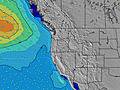 |  | 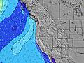 | 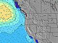 | 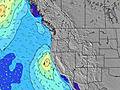 | 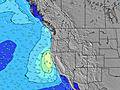 | 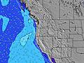 | ||||||||||||||
Wave Height (m) Direction Period (s) | NW 8 | NNW 7 | NW 7 | NW 7 | NW 7 | NW 8 | NW 8 | NW 8 | NW 8 | NW 8 | NW 8 | NW 8 | NW 7 | NNW 5 | NNW 6 | NNW 6 | NNW 6 | NNW 6 | NNW 6 | NNW 6 | WNW 7 |
Wave Graph | |||||||||||||||||||||
270 | 350 | 199 | 248 | 332 | 407 | 316 | 371 | 333 | 233 | 247 | 164 | 112 | 109 | 203 | 131 | 135 | 170 | 126 | 159 | 146 | |
Wind (km/h) | |||||||||||||||||||||
Wind State on-shore cross-onshore cross-shore cross-offshore off-shore glassy | cross | cross | cross | cross | cross | cross | cross-on | cross-on | cross | cross-on | cross-on | cross | cross-on | cross | cross | cross | cross | cross | cross | cross | cross |
High Tide | 4:08PM2.36m | 4:19AM1.86m | 4:43PM2.41m | 5:26AM1.67m | 5:26PM2.45m | 6:51AM1.54m | 6:18PM2.47m | 8:29AM1.53m | 7:22PM2.50m | 9:55AM1.64m | 8:33PM2.57m | 10:58AM1.80m | 9:41PM2.66m | ||||||||
Low Tide | 9:37AM0.15m | 10:29PM0.40m | 10:12AM0.40m | 11:27PM0.30m | 10:51AM0.66m | 00:34AM0.18m | 11:42AM0.91m | 1:48AM0.04m | 12:51PM1.10m | 3:00AM-0.14m | 2:16PM1.17m | 4:05AM-0.34m | 3:36PM1.11m | ||||||||
6:03 | — | — | 6:05 | — | — | 6:05 | — | — | 6:07 | — | — | 6:07 | — | — | 6:09 | — | — | 6:11 | — | — | |
— | 8:39 | — | — | 8:37 | — | — | 8:37 | — | — | 8:35 | — | — | 8:34 | — | — | 8:32 | — | — | 8:30 | — | |
mm | — | — | — | — | — | — | — | — | — | — | — | — | — | — | — | — | — | — | — | — | — |
Temp °C | 17 | 20 | 17 | 21 | 21 | 17 | 19 | 19 | 16 | 17 | 18 | 15 | 17 | 18 | 16 | 18 | 18 | 15 | 18 | 17 | 16 |
Feels °C | 14 | 15 | 13 | 18 | 18 | 14 | 17 | 17 | 15 | 17 | 17 | 14 | 15 | 14 | 12 | 14 | 14 | 11 | 15 | 13 | 13 |
Swell 1 Height (m) Direction Period (s) | SW 13 | SW 13 | NW 7 | NW 7 | SW 16 | SW 15 | NW 8 | SW 14 | NW 8 | NW 8 | SW 13 | NW 8 | SW 13 | SW 13 | WNW 12 | SW 12 | WNW 11 | WNW 11 | WNW 10 | WNW 10 | WNW 7 |
27 | 27 | 199 | 248 | 63 | 56 | 316 | 53 | 333 | 233 | 63 | 164 | 60 | 58 | 46 | 55 | 45 | 38 | 37 | 36 | 146 | |
Swell 2 Height (m) Direction Period (s) | WSW 18 | WSW 17 | WSW 16 | WSW 16 | SSW 12 | SW 12 | SW 15 | W 21 | SW 14 | WSW 14 | WSW 19 | SW 13 | WNW 8 | SW 18 | SW 13 | WNW 11 | SW 13 | SW 17 | SW 16 | SW 16 | SW 16 |
30 | 28 | 25 | 25 | 14 | 6 | 54 | 9 | 50 | 74 | 37 | 61 | 13 | 50 | 57 | 46 | 56 | 76 | 63 | 87 | 62 | |
Swell 3 Height (m) Direction Period (s) | — | — | SW 13 | SW 12 | — | — | SSW 12 | W 21 | SW 11 | SSW 11 | W 16 | WNW 8 | WSW 18 | WNW 8 | SW 18 | SW 16 | SW 16 | SW 12 | W 12 | SW 12 | W 12 |
— | — | 26 | 24 | — | — | 14 | 9 | 5 | 12 | 5 | 14 | 31 | 6 | 49 | 68 | 68 | 22 | 28 | 22 | 12 | |
Wind waves Height (m) Direction Period (s) | NW 8 | NNW 7 | N 6 | — | NW 7 | NW 8 | — | NW 8 | — | — | NW 8 | — | NW 7 | NNW 5 | NNW 6 | NNW 6 | NNW 6 | NNW 6 | NNW 6 | NNW 6 | NNW 7 |
270 | 350 | 184 | — | 332 | 407 | — | 371 | — | — | 247 | — | 112 | 109 | 203 | 131 | 135 | 170 | 126 | 159 | 139 | |
Nearest Offshore or Glassy | |||||||||||||||||||||
Distance (km) | 235 | 406 | 20 | 235 | 316 | 1 | 272 | 272 | 1 | 240 | 488 | 1 | 332 | 525 | 1 | 406 | 2305 | 113 | 290 | 527 | 1 |
Best forecast wave conditions in North Oregon | |||||||||||||||||||||
Best forecast wave conditions in United States | |||||||||||||||||||||
Header Global | |||||||||||||||||||||
- Map Icons:
 Break
Break Live Wave Height (m)
 Live Wind Speed (km/h)
 Surf Rating (10 Max)
 Ocean Swells (m)
- Wind Speed (km/h)
Latest Updates


FREE! Surf-Forecast.com widget for your website
The surf report / weather widget below is available to embed on third party websites free of charge and provides a summary of our Otter Rock surf forecast. Simply grab the html code snippet that we provide and paste it into your own site. You can choose your preferred language and metric/imperial units for the surf forecast feed to suit users of your site. Click here to get the code.
Information about the Otter Rock Surf forecast
The above surf forecast table for Otter Rock provides essential information for determining whether the surfing conditions will be good over the next 16 days. A general guide to surfing at Otter Rock can be found by selecting the local surf guide option on the grey menu. Our Otter Rock surf forecast is unique since it includes wave energy (power) that defines the real feel of the surf rather than just the height or the period. If you surf the same spot (Otter Rock) regularly then make a mental note of the wave energy from the surf forecast table each time you go. Very soon you may start to choose your surf days based on the wave energy alone combined with our forecast of favourable offshore wind conditions. Our star ratings will help here and of course you will also find the usual wave height and period predictions on our surf forecasts as well as a full break down of the swell components under our advanced users option (to reveal that, click the little Einstein character under the tide times).
Further information to help with frequently asked questions about our surf forecast for Otter Rock may be found under the help tab on the top menu and also by moving your mouse over the question marks on the surf forecast table itself. Please always bear in mind that the forecast is for near-shore open water and local factors at each surf break influence the actual breaking wave height, such as the beach / reef profile, water depths offshore and shelter.
Otter Rock is 67 km (42 miles) from Corvallis. If you plan a vacation in North Oregon, look for hotels and other accommodation in Corvallis. Corvallis has rooms for a wide range of budgets as well as car hire and transport links.
 Nearest