

Surf Forecasts:

Margate surf forecast from 12 Jul 2026:
- Best quality surf: Monday 13 Jul, 2AM (local time) - 3.5ft (1.1m), 12s period, SSW swell with cross-offshore winds.
- Most powerful swell: Saturday 18 Jul, 8AM (local time) - 7ft (2.1m), 15s period, S swell with 2,070 kJ wave energy.
- Next surfable swell (1★+): Monday 13 Jul, 2AM (local time) - 3.5ft (1.1m), 12s period with SSW swell.
Best Forecast Surf Conditions for Margate this week:
The surf forecast for Margate over the next 16 days: The first swell (rated 1 star or higher) is forecast to arrive on Monday (Jul 13) at 2AM. The primary swell is predicted to be 1.1m and 12s period. The wind is predicted to be cross-offshore as the swell arrives.
The most powerful waves expected at Margate in the next 16 days are 2.1m 15s and forecast to arrive on Saturday (Jul 18) at 8AM. Winds are predicted to be cross-onshore at the time the swell arrives. The largest open ocean swell (not directed at the beach) is 2.2m 9s period and expected on Tuesday (Jul 14) at 8AM.
| Wave Type | Time (SAST) & Date | Wave Height & Period |
|---|---|---|
| Next good surf (1 star+) | 2AM (Mon 13th Jul) | 3.5ft (1.1m) 12s |
| Best Surf | 2AM (Mon 13th Jul) | 3.5ft (1.1m) 12s |
| Most Powerful | 8AM (Sat 18th Jul) | 7ft (2.1m) 15s |
Table - best surf conditions forecast for Margate over the next 16 days.
Right then, let’s have a proper look at what Margate’s got cookin’. It’s a pretty flat and messy story for the most part, so don’t go getting your hopes up too early. The first stretch is a total write-off – poor surf conditions across the board with cross-onshore winds and tiny, weak swell. You’re looking at a gap of almost a week before anything remotely rideable shows up.
The first real glimmer comes on Saturday the 18th. The morning has a 7ft swell out of the S, with a long period of 14 seconds, and light cross-onshore breeze. The wave energy is strong (2020), so there’s some punch there, but it’s only a marginal call due to questionable tide conditions. This one’s for the experienced crew only – that’s a solid size, and the long period will make it pitchy. It’s a beach and reef setup (Margate), so the long period groundswell should wrap in decently, but the afternoon goes limp with a fresh onshore breeze chopping it up.
After that, it’s back to frustrating stuff until the end of the following week. But hold onto your board, because Thursday the 23rd is the real standout. The afternoon offers a solid 8ft SW swell, period around 10 seconds, with a clean cross-offshore breeze. The energy is very strong (2941). This is excellent for experienced surfers – clean faces, good power, and the swell direction is right in the sweet spot from the optimum SW. It’ll be a proper session for those who know what they’re doing. The morning of that day is also clean and big, with similar energy (2843), so there’s a solid window.
After that, the outlook fades again into choppy, onshore slop through to the end of the period.
So, to wrap it up: the first week is a bust. The only two days worth circling are Saturday the 18th for a big, powerful, but tricky swell, and especially Thursday the 23rd for a top-shelf, clean, powerful afternoon. Get on it if you’re keen, but don’t bring the beginners – that 8ft is heavy.
Rusty.
Short Range ForecastLight rain (total 2mm), mostly falling on Sun night. Warm (max 21°C on Tue afternoon, min 15°C on Tue morning). Winds decreasing (fresh winds from the NE on Mon afternoon, calm by Wed morning). | Days 5-7 Weather SummaryLight rain (total 9mm), mostly falling on Fri night. Warm (max 21°C on Fri morning, min 16°C on Wed night). Winds decreasing (fresh winds from the SSW on Fri afternoon, light winds from the ESE by Sat morning). | ||||||||||||||||||||
Monday 13 | Tuesday 14 | Wednesday 15 | Thursday 16 | Friday 17 | Saturday 18 | Sun 19 | |||||||||||||||
Night | AM | PM | Night | AM | PM | Night | AM | PM | Night | AM | PM | Night | AM | PM | Night | AM | PM | Night | AM | PM | |
Swell Height Map |  |  |  |  | 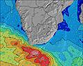 | 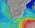 | 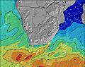 | 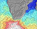 | |||||||||||||
Wave Height (m) Direction Period (s) | SSW 12 | S 11 | SSW 11 | SE 9 | S 10 | SSW 10 | SSW 10 | SSW 9 | SW 9 | SSE 10 | SW 12 | SSW 10 | SW 14 | SW 14 | SSW 16 | SSW 14 | S 14 | S 13 | S 12 | S 11 | SSE 11 |
Wave Graph | |||||||||||||||||||||
306 | 247 | 198 | 300 | 42 | 42 | 32 | 29 | 22 | 10 | 36 | 138 | 280 | 54 | 171 | 1690 | 2004 | 1708 | 948 | 573 | 210 | |
Wind (km/h) | |||||||||||||||||||||
Wind State on-shore cross-onshore cross-shore cross-offshore off-shore glassy | cross-off | cross-on | cross-on | cross | cross-on | cross-on | cross-off | glassy | cross-off | off | cross-on | cross-on | cross-off | cross-off | cross-off | cross-off | cross-on | cross-on | cross-on | cross-on | cross-on |
High Tide | 2:42AM1.58m | 3:13PM1.54m | 3:31AM1.66m | 3:59PM1.66m | 4:14AM1.70m | 4:42PM1.73m | 4:55AM1.70m | 5:23PM1.76m | 5:33AM1.66m | 6:02PM1.74m | 6:10AM1.58m | 6:40PM1.67m | 6:46AM1.48m | 7:17PM1.57m | |||||||
Low Tide | 8:23PM0.31m | 9:00AM0.19m | 9:16PM0.20m | 9:45AM0.09m | 10:04PM0.13m | 10:26AM0.03m | 10:48PM0.11m | 11:04AM0.00m | 11:29PM0.13m | 11:41AM0.03m | 00:09AM0.19m | 12:17PM0.09m | 00:47AM0.28m | 12:52PM0.19m | |||||||
— | 6:54 | — | — | 6:54 | — | — | 6:54 | — | — | 6:54 | — | — | 6:54 | — | — | 6:52 | — | — | 6:52 | — | |
5:12 | — | 5:13 | — | — | 5:13 | — | — | 5:14 | — | — | 5:14 | — | — | 5:15 | — | — | 5:15 | — | — | 5:15 | |
mm | 2 | — | — | — | — | — | — | — | — | — | — | — | — | — | — | 7 | 2 | — | 3 | — | — |
Temp °C | 17 | 19 | 20 | 18 | 20 | 21 | 18 | 21 | 21 | 18 | 19 | 20 | 19 | 21 | 21 | 19 | 16 | 16 | 17 | 18 | 21 |
Feels °C | 16 | 16 | 15 | 15 | 18 | 20 | 18 | 20 | 19 | 17 | 18 | 18 | 14 | 16 | 15 | 14 | 14 | 15 | 13 | 13 | 16 |
Swell 1 Height (m) Direction Period (s) | ESE 7 | E 7 | SSW 11 | SE 9 | E 9 | E 9 | E 10 | E 10 | E 10 | E 10 | E 10 | E 10 | E 10 | E 10 | E 10 | SSW 14 | S 14 | S 13 | S 12 | S 11 | SSE 11 |
250 | 315 | 198 | 300 | 718 | 750 | 753 | 694 | 637 | 502 | 450 | 384 | 384 | 273 | 188 | 1690 | 2004 | 1708 | 948 | 573 | 210 | |
Swell 2 Height (m) Direction Period (s) | SSW 12 | S 11 | S 13 | SSW 11 | S 10 | SSW 10 | SSW 10 | SSW 9 | SW 9 | SSE 10 | SSW 8 | SSW 10 | SW 14 | SW 14 | SSW 16 | E 10 | E 10 | E 10 | E 10 | ENE 7 | S 11 |
306 | 247 | 30 | 121 | 30 | 42 | 32 | 29 | 22 | 10 | 27 | 138 | 280 | 54 | 171 | 153 | 188 | 113 | 64 | 102 | 191 | |
Swell 3 Height (m) Direction Period (s) | S 15 | S 13 | — | SW 15 | SSW 10 | SSE 10 | SW 16 | S 11 | SSE 11 | SSW 9 | SW 12 | SW 16 | SE 10 | S 10 | SSW 12 | NNE 6 | E 10 | — | — | E 9 | ENE 7 |
38 | 56 | — | 8 | 42 | 31 | 10 | 2 | 11 | 8 | 36 | 125 | 4 | 2 | 54 | 3 | 116 | — | — | 61 | 64 | |
Wind waves Height (m) Direction Period (s) | — | E 7 | E 8 | ENE 8 | NNE 5 | — | N 4 | — | SSW 4 | SW 4 | — | NE 3 | NNE 4 | SSW 5 | SSW 6 | — | NE 4 | NE 5 | NE 6 | — | — |
— | 478 | 463 | 336 | 28 | — | 22 | — | 8 | 4 | — | 6 | 21 | 88 | 65 | — | 16 | 115 | 164 | — | — | |
Nearest Offshore or Glassy | |||||||||||||||||||||
Distance (km) | 0 | 127 | 127 | 90 | 90 | 90 | 9 | 9 | 9 | 9 | 78 | 127 | 0 | 283 | 619 | 76 | 9 | 127 | 236 | 384 | 349 |
Best forecast wave conditions in Durban/KwaZulu-Natal South Coast | |||||||||||||||||||||
Best forecast wave conditions in South Africa | |||||||||||||||||||||
Header Global | |||||||||||||||||||||
- Map Icons:
 Break
Break Live Wave Height (m)
 Live Wind Speed (km/h)
 Surf Rating (10 Max)
 Ocean Swells (m)
- Wind Speed (km/h)


FREE! Surf-Forecast.com widget for your website
The surf report / weather widget below is available to embed on third party websites free of charge and provides a summary of our Margate surf forecast. Simply grab the html code snippet that we provide and paste it into your own site. You can choose your preferred language and metric/imperial units for the surf forecast feed to suit users of your site. Click here to get the code.
Information about the Margate Surf forecast
The above surf forecast table for Margate provides essential information for determining whether the surfing conditions will be good over the next 16 days. A general guide to surfing at Margate can be found by selecting the local surf guide option on the grey menu. Our Margate surf forecast is unique since it includes wave energy (power) that defines the real feel of the surf rather than just the height or the period. If you surf the same spot (Margate) regularly then make a mental note of the wave energy from the surf forecast table each time you go. Very soon you may start to choose your surf days based on the wave energy alone combined with our forecast of favourable offshore wind conditions. Our star ratings will help here and of course you will also find the usual wave height and period predictions on our surf forecasts as well as a full break down of the swell components under our advanced users option (to reveal that, click the little Einstein character under the tide times).
Further information to help with frequently asked questions about our surf forecast for Margate may be found under the help tab on the top menu and also by moving your mouse over the question marks on the surf forecast table itself. Please always bear in mind that the forecast is for near-shore open water and local factors at each surf break influence the actual breaking wave height, such as the beach / reef profile, water depths offshore and shelter.
Are you planning a holiday in Durban/KwaZulu-Natal South Coast? If you are looking for accommodation near Margate, camping, hotels and holiday cottages in Durban/KwaZulu-Natal South Coast, consider staying in Margate which is 1 km (1 miles) away. Other places in and around Durban/KwaZulu-Natal South Coast where you can find information about places to rent, and car hire include Port Shepstone which is 14 km (9 miles) away, Ntuzuma, Scottburgh and Umkomaas.
 Nearest