

Surf Forecasts:

Lincoln City surf forecast from 3 Aug 2026:
- Best quality surf: Monday 3 Aug, 5AM (local time) - 4.5ft (1.3m), 8s period, WNW swell with cross-offshore winds.
- Most powerful swell: Tuesday 4 Aug, 11PM (local time) - 7ft (2.1m), 7s period, NW swell with 452 kJ wave energy.
- Next surfable swell (1★+): Monday 3 Aug, 5AM (local time) - 4.5ft (1.3m), 8s period with WNW swell.
Best Forecast Surf Conditions for Lincoln City this week:
The surf forecast for Lincoln City over the next 16 days: The first swell (rated 1 star or higher) is forecast to arrive on Monday (Aug 03) at 5AM. The primary swell is predicted to be 1.3m and 8s period with a secondary swell of 0.4m and 13s. Another secondary swell of 0.9m and 5s is also forecast. The wind is predicted to be cross-offshore as the swell arrives.
The most powerful waves expected at Lincoln City in the next 16 days are 2.1m 7s and forecast to arrive on Tuesday (Aug 04) at 11PM. Winds are predicted to be cross-shore at the time the swell arrives.
| Wave Type | Time (PDT) & Date | Wave Height & Period |
|---|---|---|
| Next good surf (1 star+) | 5AM (Mon 3rd Aug) | 4.5ft (1.3m) 8s |
| Best Surf | 5AM (Mon 3rd Aug) | 4.5ft (1.3m) 8s |
| Most Powerful | 11PM (Tue 4th Aug) | 7ft (2.1m) 7s |
Table - best surf conditions forecast for Lincoln City over the next 16 days.
The Lowdown
Alright, this is Rusty, and I’m looking at the surf forecast for Lincoln City (Oregon). It’s a beach and reef setup that’s fairly consistent and exposed to the west, with an optimum swell direction from the west. Right now, the water temp is about average for this time of year, nothing wild.
Honestly, the next couple of weeks are a bit of a grind. The first few days, from Monday the 3rd through to the end of the first week, are a real struggle. We’ve got swell in the 4ft to 7ft range, mostly from the NW and NNW, with periods around 6 to 8 seconds – that’s short-period, wind-slop stuff. The combined wave energy is weak to moderate, but the wind is a persistent cross-shore or cross-onshore. That means the surf is consistently poor, with a cross-chop or choppy conditions. There’s a few sessions that are just marginal, but nothing you’d want to paddle out for. The best you can say is by Monday afternoon on the 10th, the swell bumps up to 7ft from the NW with a 9-second period, and the energy climbs, but it’s still cross-shore. It’s messy.
The second week doesn’t really turn the corner either. From the 11th to the 15th, we see swell heights holding around 6ft to 7ft, mostly from the NW, with periods still in the 8 to 9 second range. The combined energy gets stronger, so there’s power in the water, but the wind stays cross or cross-onshore. On the 14th, we hit a moderate energy with a 7ft NW swell, but again, it’s cross-onshore and fairly choppy. The mornings on the 14th and 16th see a light breeze, which might give a brief window of cleaner surf, but it’s still a cross-onshore direction. For a beach and reef setup, this is looking more like a kite-surfing kind of session than clean waves for paddling.
The standout moment, if you can call it that, is possibly the morning of the 14th. The swell is 7ft from the NW with an 8-second period, combined energy moderate, and a light cross-onshore breeze. It’s the best score of the whole run, but it’s still marginal. By the 17th and 18th, the swell drops right off to 2ft to 2ft, with a long period of 15 to 16 seconds, but that’s just a weak, long-period groundswell that won’t do much at a beach break. The wind is variable and won’t help.
In short, the whole 16-day window is a flat, messy pattern. There’s no real standout session. The consistent cross-winds and short-period swell are just not cooperating. If you’re desperate, maybe keep an eye on the 14th morning, but don’t hold your breath. This is a run where the forecast can change, but right now, it’s a blank.
Rusty.
Short Range ForecastMostly dry. Warm (max 24°C on Tue morning, min 11°C on Sun night). Wind will be generally light. | Days 5-7 Weather SummaryMostly dry. Very mild (max 19°C on Thu afternoon, min 13°C on Wed night). Wind will be generally light. | ||||||||||||||||||
Monday 3 | Tuesday 4 | Wednesday 5 | Thursday 6 | Friday 7 | Saturday 8 | ||||||||||||||
Night | AM | PM | Night | AM | PM | Night | AM | PM | Night | AM | PM | Night | AM | PM | Night | AM | PM | Night | |
Swell Height Map |  |  |  |  | 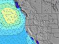 | 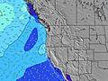 | 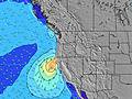 | ||||||||||||
Wave Height (m) Direction Period (s) | WNW 8 | NW 8 | NNW 6 | NNW 7 | NW 7 | NW 7 | NW 7 | NW 8 | NW 8 | NW 8 | NW 8 | NW 8 | NW 8 | NW 7 | NNW 7 | NNW 7 | NNW 6 | NNW 7 | NNW 7 |
Wave Graph | |||||||||||||||||||
277 | 239 | 319 | 332 | 234 | 352 | 396 | 352 | 380 | 352 | 239 | 277 | 204 | 151 | 158 | 170 | 132 | 216 | 257 | |
Wind (km/h) | |||||||||||||||||||
Wind State on-shore cross-onshore cross-shore cross-offshore off-shore glassy | cross-off | cross | cross | cross-off | cross | cross | cross | cross-on | cross | cross | cross-on | cross-on | cross | cross-on | cross | cross-off | cross | cross | cross |
High Tide | 3:43AM1.64m | 4:29PM1.90m | 4:40AM1.49m | 5:04PM1.95m | 5:50AM1.35m | 5:46PM2.00m | 7:17AM1.27m | 6:38PM2.03m | 8:55AM1.27m | 7:41PM2.07m | 10:18AM1.35m | 8:49PM2.13m | |||||||
Low Tide | 10:23PM0.42m | 10:21AM0.18m | 11:16PM0.34m | 10:55AM0.34m | 00:16AM0.27m | 11:35AM0.51m | 1:23AM0.18m | 12:25PM0.66m | 2:36AM0.08m | 1:32PM0.77m | 3:47AM-0.04m | 2:54PM0.81m | 4:50AM-0.16m | ||||||
— | 6:03 | — | — | 6:03 | — | — | 6:05 | — | — | 6:05 | — | — | 6:07 | — | — | 6:09 | — | — | |
8:40 | — | 8:39 | — | — | 8:38 | — | — | 8:37 | — | — | 8:36 | — | — | 8:34 | — | — | 8:32 | — | |
mm | — | — | — | — | — | — | — | — | — | — | — | — | — | — | — | — | — | — | — |
Temp °C | 15 | 19 | 20 | 16 | 24 | 23 | 17 | 21 | 20 | 16 | 18 | 19 | 15 | 18 | 18 | 15 | 18 | 18 | 15 |
Feels °C | 11 | 16 | 15 | 13 | 21 | 20 | 15 | 20 | 18 | 15 | 18 | 18 | 14 | 16 | 16 | 13 | 15 | 15 | 12 |
Swell 1 Height (m) Direction Period (s) | WNW 8 | SW 13 | SW 13 | SW 16 | WSW 16 | SW 16 | SW 15 | SW 15 | SW 14 | NW 8 | NW 8 | SW 13 | SW 13 | SW 13 | SW 13 | WNW 12 | WNW 11 | WNW 11 | WNW 11 |
277 | 44 | 27 | 41 | 25 | 64 | 56 | 54 | 73 | 352 | 239 | 63 | 61 | 59 | 58 | 46 | 47 | 45 | 64 | |
Swell 2 Height (m) Direction Period (s) | SW 13 | WSW 18 | WSW 17 | SW 13 | SSW 12 | SSW 12 | SSW 12 | SSW 12 | SW 14 | SW 14 | SW 14 | SW 19 | WNW 8 | WNW 15 | WNW 8 | SW 13 | SW 12 | SW 12 | SW 17 |
45 | 30 | 29 | 26 | 15 | 14 | 14 | 14 | 53 | 68 | 66 | 15 | 14 | 21 | 12 | 56 | 39 | 55 | 45 | |
Swell 3 Height (m) Direction Period (s) | WSW 18 | — | — | SW 13 | SW 12 | — | — | — | W 21 | SW 11 | SSW 11 | W 16 | W 12 | WSW 18 | SW 18 | SW 18 | SW 16 | SW 16 | SW 12 |
31 | — | — | 26 | 24 | — | — | — | 9 | 5 | 12 | 5 | 12 | 31 | 49 | 48 | 42 | 67 | 23 | |
Wind waves Height (m) Direction Period (s) | N 5 | NW 8 | NNW 6 | NNW 7 | NW 7 | NW 7 | NW 7 | NW 8 | NW 8 | — | — | NW 8 | NW 8 | NW 7 | NNW 7 | NNW 7 | NNW 6 | NNW 7 | NNW 7 |
50 | 239 | 319 | 332 | 234 | 352 | 396 | 352 | 380 | — | — | 277 | 204 | 151 | 158 | 170 | 132 | 216 | 257 | |
Nearest Offshore or Glassy | |||||||||||||||||||
Distance (km) | 1 | 214 | 384 | 1 | 214 | 337 | 1 | 148 | 293 | 22 | 219 | 468 | 22 | 353 | 548 | 1 | 358 | 378 | 337 |
Best forecast wave conditions in North Oregon | |||||||||||||||||||
Best forecast wave conditions in United States | |||||||||||||||||||
Header Global | |||||||||||||||||||
- Map Icons:
 Break
Break Live Wave Height (m)
 Live Wind Speed (km/h)
 Surf Rating (10 Max)
 Ocean Swells (m)
- Wind Speed (km/h)
Latest Updates


FREE! Surf-Forecast.com widget for your website
The surf report / weather widget below is available to embed on third party websites free of charge and provides a summary of our Lincoln City surf forecast. Simply grab the html code snippet that we provide and paste it into your own site. You can choose your preferred language and metric/imperial units for the surf forecast feed to suit users of your site. Click here to get the code.
Information about the Lincoln City Surf forecast
The above surf forecast table for Lincoln City provides essential information for determining whether the surfing conditions will be good over the next 16 days. A general guide to surfing at Lincoln City can be found by selecting the local surf guide option on the grey menu. Our Lincoln City surf forecast is unique since it includes wave energy (power) that defines the real feel of the surf rather than just the height or the period. If you surf the same spot (Lincoln City) regularly then make a mental note of the wave energy from the surf forecast table each time you go. Very soon you may start to choose your surf days based on the wave energy alone combined with our forecast of favourable offshore wind conditions. Our star ratings will help here and of course you will also find the usual wave height and period predictions on our surf forecasts as well as a full break down of the swell components under our advanced users option (to reveal that, click the little Einstein character under the tide times).
Further information to help with frequently asked questions about our surf forecast for Lincoln City may be found under the help tab on the top menu and also by moving your mouse over the question marks on the surf forecast table itself. Please always bear in mind that the forecast is for near-shore open water and local factors at each surf break influence the actual breaking wave height, such as the beach / reef profile, water depths offshore and shelter.
Lincoln City is 72 km (45 miles) from the city of McMinnville. If you plan a vacation in North Oregon, look for hotels and other accommodation in McMinnville. McMinnville has rooms for a wide range of budgets as well as car hire and transport links.
 Nearest