

Surf Forecasts:

Jan Juc surf forecast from 23 Jul 2026:
- Best quality surf: Thursday 23 Jul, 10PM (local time) - 8ft (2.5m), 16s period, SW swell with cross-offshore winds.
- Most powerful swell: Friday 24 Jul, 4AM (local time) - 16ft (5.0m), 15s period, SW swell with 10,751 kJ wave energy.
- Next surfable swell (1★+): Thursday 23 Jul, 10PM (local time) - 8ft (2.5m), 16s period with SW swell.
Best Forecast Surf Conditions for Jan Juc this week:
The surf forecast for Jan Juc over the next 16 days: The first swell (rated 1 star or higher) is forecast to arrive on Thursday (Jul 23) at 10PM. The primary swell is predicted to be 2.5m and 16s period with a secondary swell of 3.0m and 13s. The wind is predicted to be cross-offshore as the swell arrives.
The most powerful waves expected at Jan Juc in the next 16 days are 5.0m 15s and forecast to arrive on Friday (Jul 24) at 4AM. Winds are predicted to be cross-offshore at the time the swell arrives. The largest open ocean swell (not directed at the beach) is 0.8m 4s period and expected on Tuesday (Jul 28) at 4PM.
| Wave Type | Time (AEST) & Date | Wave Height & Period |
|---|---|---|
| Next good surf (1 star+) | 10PM (Thu 23rd Jul) | 8ft (2.5m) 16s |
| Best Surf | 10PM (Thu 23rd Jul) | 8ft (2.5m) 16s |
| Most Powerful | 4AM (Fri 24th Jul) | 16ft (5.0m) 15s |
Table - best surf conditions forecast for Jan Juc over the next 16 days.
The Lowdown
Alright folks, Rusty here. Let’s have a proper look at what’s on the cards for our local stretch.
Right off the bat, we’re looking at a mixed bag. The first few days are going to be a write-off for most of us, with some serious size coming through that’s just too much for a standard paddle. The water temp is sitting at 57°, which is pretty much standard for this time of year, so nothing to stress about in the wetsuit department.
The first real chance to get wet doesn’t pop up until Sunday the 26th of July, but even then it’s a bit of a tease. The morning at Jan Juc has a small 4ft swell from the SSW with moderate energy (438), but it’s looking a bit weak and the conditions aren't inspiring. The afternoon picks up to a meaty 8ft from the SW with a solid energy reading (1737), but that’s still too big for a comfortable session for most.
Monday the 27th is where things start to look a bit more promising. The morning has a nice 4ft SW swell with offshore winds and clean conditions. The energy is low (268), but that offshore breeze is a major positive. The afternoon stays clean with a light 4ft swell and a gentle offshore, making it a good option for a quieter session.
Now, the real standout here is a window that opens up on Thursday the 30th of July. The morning is looking absolutely glassy, with a 4ft SSW swell and a period of 12 seconds. The energy is moderate (531), and the wind is dead calm. That’s the kind of morning you set an alarm for. The afternoon stays glassy with a smaller 4ft swell, but it’s still clean and fun.
We’ve got a bit of a dry spell after that, with a few days of messy, onshore wind and dodgy conditions. Then there’s another interesting window on Sunday the 2nd of August. The morning is looking clean with a 7ft SSW swell, but that’s getting into the bigger territory, so it’s one for the experienced crew. The energy is strong (1973), and the light offshore breeze will keep it tidy.
The best bet of the whole period? I’d be all over Thursday the 30th of July. That glassy morning with clean 4ft swell is the pick of the bunch. The following Sunday the 2nd of August is a solid option for the more experienced surfers, but that Thursday is a gem.
Rusty.
Short Range ForecastLight rain (total 2mm), mostly falling on Fri night. Very mild (max 14°C on Sat afternoon, min 9°C on Thu afternoon). Mainly fresh winds. | Days 5-7 Weather SummaryLight rain (total 6mm), mostly falling on Tue afternoon. Very mild (max 17°C on Tue morning, min 8°C on Tue night). Mainly fresh winds. | |||||||||||||||||||
Thu 23 | Friday 24 | Saturday 25 | Sunday 26 | Monday 27 | Tuesday 28 | Wednesday 29 | ||||||||||||||
PM | Night | AM | PM | Night | AM | PM | Night | AM | PM | Night | AM | PM | Night | AM | PM | Night | AM | PM | Night | |
Swell Height Map |  |  |  | 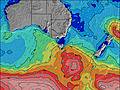 | 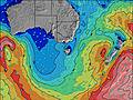 | 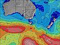 | 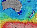 | |||||||||||||
Wave Height (m) Direction Period (s) | SW 14 | SSW 16 | SSW 15 | SSW 15 | SSW 14 | SW 13 | SSW 12 | SSW 12 | SSW 11 | SW 10 | SW 10 | SW 10 | SW 11 | SW 13 | SSW 16 | SSW 16 | SSW 15 | SSW 14 | SSW 14 | SSW 13 |
Wave Graph | ||||||||||||||||||||
3293 | 3691 | 3464 | 2381 | 1710 | 3586 | 1016 | 636 | 411 | 1334 | 298 | 234 | 320 | 471 | 1273 | 1225 | 1209 | 1578 | 1212 | 787 | |
Wind (km/h) | ||||||||||||||||||||
Wind State on-shore cross-onshore cross-shore cross-offshore off-shore glassy | cross-off | cross-off | cross-off | cross-off | cross-off | cross-off | cross-off | cross-off | cross-off | cross-off | off | off | off | cross-off | off | off | cross-off | cross-on | cross-on | cross |
High Tide | 9:03PM0.51m | 11:53AM0.39m | 9:40PM0.50m | 1:04PM0.38m | 10:22PM0.49m | 3:00PM0.38m | 11:08PM0.48m | 4:42PM0.40m | 00:00AM0.47m | 5:35PM0.42m | 00:55AM0.46m | 6:12PM0.43m | 1:50AM0.45m | |||||||
Low Tide | 4:46AM0.10m | 4:33PM0.29m | 5:36AM0.11m | 5:20PM0.33m | 6:33AM0.12m | 6:24PM0.36m | 7:36AM0.12m | 7:48PM0.37m | 8:37AM0.11m | 9:03PM0.36m | 9:31AM0.09m | 10:01PM0.33m | ||||||||
— | — | 7:31 | — | — | 7:30 | — | — | 7:30 | — | — | 7:28 | — | — | 7:28 | — | — | 7:26 | — | — | |
5:25 | — | — | 5:27 | — | — | 5:28 | — | — | 5:28 | — | — | 5:29 | — | — | 5:30 | — | — | 5:30 | — | |
mm | — | — | — | — | 2 | — | — | — | — | — | — | — | — | — | — | 6 | — | — | — | — |
Temp °C | 11 | 10 | 12 | 12 | 12 | 13 | 14 | 12 | 13 | 15 | 12 | 14 | 15 | 14 | 17 | 12 | 9 | 11 | 11 | 11 |
Feels °C | 4 | 4 | 6 | 5 | 8 | 8 | 9 | 7 | 9 | 11 | 8 | 9 | 11 | 8 | 10 | 6 | 4 | 6 | 8 | 8 |
Swell 1 Height (m) Direction Period (s) | SW 14 | SSW 16 | SSW 15 | SSW 15 | SSW 14 | SSW 13 | SSW 12 | SSW 12 | SSW 11 | SW 10 | SW 10 | SW 10 | SW 11 | SW 13 | SSW 16 | SSW 16 | SSW 15 | SSW 14 | SSW 14 | SSW 13 |
1977 | 3691 | 3464 | 2381 | 1710 | 1341 | 1016 | 636 | 411 | 392 | 298 | 234 | 320 | 471 | 1273 | 1225 | 1209 | 1578 | 1212 | 787 | |
Swell 2 Height (m) Direction Period (s) | SSW 18 | — | S 15 | S 14 | — | — | S 13 | — | WSW 16 | SW 16 | SSW 16 | SW 15 | SW 14 | S 14 | S 16 | S 15 | S 16 | SW 22 | — | WSW 12 |
128 | — | 294 | 192 | — | — | 54 | — | 27 | 11 | 26 | 34 | 121 | 36 | 46 | 112 | 119 | 18 | — | 14 | |
Swell 3 Height (m) Direction Period (s) | — | — | — | — | — | — | — | — | — | — | — | — | — | — | — | — | — | — | — | — |
— | — | — | — | — | — | — | — | — | — | — | — | — | — | — | — | — | — | — | — | |
Wind waves Height (m) Direction Period (s) | SW 14 | SW 13 | — | W 3 | WNW 3 | SW 13 | — | WNW 3 | WNW 2 | SW 10 | WNW 2 | WNW 2 | — | NW 3 | N 3 | NW 4 | SSW 5 | — | — | — |
3293 | 3409 | — | 5 | 6 | 3586 | — | 1 | 1 | 1334 | 1 | 1 | — | 3 | 6 | 17 | 37 | — | — | — | |
Nearest Offshore or Glassy | ||||||||||||||||||||
Distance (km) | 3 | 3 | 2 | 516 | 2 | 2 | 2 | 2 | 2 | 3 | 0 | 0 | 0 | 1 | 532 | 544 | 3 | 3 | 14 | 2 |
Best forecast wave conditions in Torquay | ||||||||||||||||||||
Best forecast wave conditions in Australia | ||||||||||||||||||||
Header Global | ||||||||||||||||||||
- Map Icons:
 Break
Break Live Wave Height (m)
 Live Wind Speed (km/h)
 Surf Rating (10 Max)
 Ocean Swells (m)
- Wind Speed (km/h)


FREE! Surf-Forecast.com widget for your website
The surf report / weather widget below is available to embed on third party websites free of charge and provides a summary of our Jan Juc surf forecast. Simply grab the html code snippet that we provide and paste it into your own site. You can choose your preferred language and metric/imperial units for the surf forecast feed to suit users of your site. Click here to get the code.
Information about the Jan Juc Surf forecast
The above surf forecast table for Jan Juc provides essential information for determining whether the surfing conditions will be good over the next 16 days. A general guide to surfing at Jan Juc can be found by selecting the local surf guide option on the grey menu. Our Jan Juc surf forecast is unique since it includes wave energy (power) that defines the real feel of the surf rather than just the height or the period. If you surf the same spot (Jan Juc) regularly then make a mental note of the wave energy from the surf forecast table each time you go. Very soon you may start to choose your surf days based on the wave energy alone combined with our forecast of favourable offshore wind conditions. Our star ratings will help here and of course you will also find the usual wave height and period predictions on our surf forecasts as well as a full break down of the swell components under our advanced users option (to reveal that, click the little Einstein character under the tide times).
Further information to help with frequently asked questions about our surf forecast for Jan Juc may be found under the help tab on the top menu and also by moving your mouse over the question marks on the surf forecast table itself. Please always bear in mind that the forecast is for near-shore open water and local factors at each surf break influence the actual breaking wave height, such as the beach / reef profile, water depths offshore and shelter.
Jan Juc is 22 km (14 miles) from the city of Geelong. If you plan a holiday in Torquay, look for hotels and other accommodation in Geelong. Geelong has rooms for a wide range of budgets as well as car hire and transport links.
 Nearest