

Surf Forecasts:

How big are the waves at Faro today (03 Aug):
The current surf forecast for Faro at 4PM is: 0.4m 4s primary swell from a West-northwest direction and 0.3m 4s secondary swell from a South direction (forecast issued at 01:00pm August 03). The wind direction is predicted to be cross-offshore.
Short Range ForecastSome drizzle, heaviest during Wed night. Warm (max 23°C on Wed night, min 17°C on Mon night). Winds increasing (light winds from the S on Tue afternoon, fresh winds from the S by Wed afternoon). | |||||||||||||||||||||
Mon 3 | Tuesday 4 | Wednesday 5 | |||||||||||||||||||
11 AM | 2 PM | 5 PM | 8 PM | 11 PM | 2 AM | 5 AM | 8 AM | 11 AM | 2 PM | 5 PM | 8 PM | 11 PM | 2 AM | 5 AM | 8 AM | 11 AM | 2 PM | 5 PM | 8 PM | 11 PM | |
Swell Height Map | 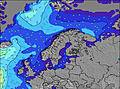 | 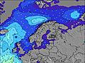 | 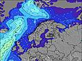 | 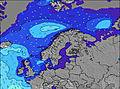 | 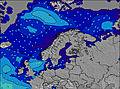 | 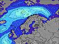 | 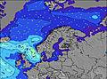 | 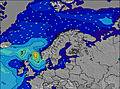 | |||||||||||||
Wave Height (m) Direction Period (s) | WNW 4 | W 4 | WNW 4 | S 4 | W 5 | W 6 | W 6 | W 5 | SSW 3 | S 3 | S 3 | S 3 | — | SSE 2 | SSE 3 | SSE 2 | SSE 3 | SSE 4 | S 5 | S 5 | SSW 5 |
Wave Graph | |||||||||||||||||||||
10 | 0 | 5 | 0 | 1 | 1 | 1 | 1 | 0 | 1 | 1 | 1 | 0 | 1 | 1 | 1 | 3 | 19 | 50 | 0 | 0 | |
Wind (km/h) | |||||||||||||||||||||
Wind State on-shore cross-onshore cross-shore cross-offshore off-shore glassy | cross-off | cross-off | cross-off | cross-off | cross-off | cross-off | cross-off | cross-off | cross | cross-off | cross | cross | cross | cross | cross | cross | cross | cross | cross | cross-off | cross-off |
High Tide | 9:38AM0.00m | 10:18PM0.00m | 10:33AM0.00m | 11:04PM0.00m | 11:47AM0.00m | ||||||||||||||||
Low Tide | 3:50PM-0.00m | 4:31AM-0.00m | 4:44PM-0.00m | 5:27AM-0.00m | 6:02PM-0.00m | ||||||||||||||||
— | — | — | — | — | 4:41 | — | — | — | — | — | — | — | 4:43 | — | — | — | — | — | — | — | |
— | — | — | 8:57 | — | — | — | — | — | — | — | 8:54 | — | — | — | — | — | — | — | 8:52 | — | |
mm | — | — | — | — | — | — | — | — | — | — | — | — | — | — | — | — | — | — | — | 1 | — |
Temp °C | 18 | 18 | 19 | 18 | 18 | 17 | 17 | 17 | 18 | 18 | 18 | 19 | 19 | 19 | 18 | 18 | 19 | 18 | 18 | 19 | 23 |
Feels °C | 15 | 14 | 16 | 13 | 14 | 13 | 14 | 14 | 15 | 15 | 16 | 15 | 15 | 16 | 14 | 14 | 16 | 14 | 14 | 16 | 19 |
Swell 1 Height (m) Direction Period (s) | WNW 4 | S 3 | WNW 4 | — | — | W 6 | W 6 | W 5 | — | — | — | — | — | — | — | — | — | — | — | — | — |
10 | 1 | 5 | — | — | 1 | 1 | 1 | — | — | — | — | — | — | — | — | — | — | — | — | — | |
Swell 2 Height (m) Direction Period (s) | — | — | — | — | W 5 | — | — | — | — | — | — | — | — | — | — | — | — | — | — | — | — |
— | — | — | — | 1 | — | — | — | — | — | — | — | — | — | — | — | — | — | — | — | — | |
Swell 3 Height (m) Direction Period (s) | — | — | — | — | — | — | — | — | — | — | — | — | — | — | — | — | — | — | — | — | — |
— | — | — | — | — | — | — | — | — | — | — | — | — | — | — | — | — | — | — | — | — | |
Wind waves Height (m) Direction Period (s) | W 4 | W 4 | S 4 | S 4 | S 4 | SSW 4 | SSW 3 | SSW 3 | SSW 3 | S 3 | S 3 | S 3 | — | SSE 2 | SSE 3 | SSE 2 | SSE 3 | SSE 4 | S 5 | S 5 | SSW 5 |
12 | 8 | 2 | 7 | 10 | 5 | 4 | 4 | 2 | 1 | 1 | 1 | — | 1 | 1 | 1 | 3 | 19 | 50 | 44 | 39 | |
Nearest Offshore or Glassy | |||||||||||||||||||||
Distance (km) | 808 | 1060 | 1186 | 1323 | 652 | 652 | 712 | 809 | 809 | 1286 | 1299 | 1281 | 1275 | 1254 | 1258 | 1182 | 1182 | 1182 | 1182 | 1905 | 126 |
Best forecast wave conditions in Baltic | |||||||||||||||||||||
Best forecast wave conditions in Sweden | |||||||||||||||||||||
Header Global | |||||||||||||||||||||
- Map Icons:
 Break
Break Live Wave Height (m)
 Live Wind Speed (km/h)
 Surf Rating (10 Max)
 Ocean Swells (m)
- Wind Speed (km/h)
Latest Updates


FREE! Surf-Forecast.com widget for your website
The surf report / weather widget below is available to embed on third party websites free of charge and provides a summary of our Faro surf forecast. Simply grab the html code snippet that we provide and paste it into your own site. You can choose your preferred language and metric/imperial units for the surf forecast feed to suit users of your site. Click here to get the code.
 Nearest