

Surf Forecasts:

Dogmans (Rincon) surf forecast from 3 Aug 2026:
- Most powerful swell: Saturday 8 Aug, 11AM (local time) - 2ft (0.6m), 6s period, NNE swell with 27 kJ wave energy.
Best Forecast Surf Conditions for Dogmans (Rincon) this week:
The most powerful waves expected at Dogmans (Rincon) in the next 16 days are 0.6m 6s and forecast to arrive on Saturday (Aug 08) at 11AM. Winds are predicted to be glassy at the time the swell arrives. The largest open ocean swell (not directed at the beach) is 1.3m 6s period and expected on Saturday (Aug 08) at 8PM.
| Wave Type | Time (AST) & Date | Wave Height & Period |
|---|---|---|
| Next good surf (1 star+) | - | - |
| Best Surf | - | - |
| Most Powerful | 11AM (Sat 8th Aug) | 2ft (0.6m) 6s |
Table - best surf conditions forecast for Dogmans (Rincon) over the next 16 days.
The Lowdown
Alright, let’s get into it. To be straight with you, the next couple of weeks are looking pretty slim. There’s a big flat spell on the cards, so don’t get your hopes up for anything rideable for a while. We’re looking at a stretch of days with nothing but tiny, dribbly leftovers and a whole lot of glassy but empty water. If you’re keen for a paddle, you’ll be doing it for the exercise, not the waves.
The outlook starts with a blank run. From Monday the 3rd through to the morning of Saturday the 8th, there’s basically nothing. A few ripples here and there, but nothing with any push. It’s going to be a frustrating few days for anyone watching the horizon. The afternoons might offer a tiny crumble, but honestly, it’s not worth the drive.
Finally, on Saturday morning the 8th, there’s a slight pulse of swell, around `2ft` from the NNE with a short, weak period of 6 seconds. It’s marginal at best, and the energy is next to nothing (35). The wind is light offshore though, so it might be glassy, but with that size and period, you’re looking at closeouts or nothing.
The rest of that week stays in the same vein. Tiny waves, mostly under `0.7ft`, with periods bouncing between 6 and 12 seconds. There’s a glimmer on Friday morning the 14th, with a slightly bigger `0.7ft` but a longer period of 12 seconds, giving it a touch more push. Still, it’s a wave for the longboard and a lot of patience, not for getting stoked about. The wind stays mostly light or offshore, but the swell just isn’t there.
The water temp is sitting at a warm `84°F`, which is about `1°F` warmer than usual for this time of year. It’s a touch warm, but nothing crazy.
Honestly, for the next 16 days, there are no standouts at all. The finder doesn’t have a single decent option. It’s a flat, blank run, and that can happen here. The breaks are mostly inconsistent, and the swell just isn’t cooperating. I’d say keep the board in the car, but don’t hold your breath. It’s a good time to work on your tan or your pop-up on the grass, because the surf is a no-go.
If you are desperate, you might find a knee-high ripple at Dogmans (Rincon) on the morning of the 14th or 15th with the longer period, but it’s a real long shot. The wind will be light and offshore, which is nice, but with that little energy, it’s about as exciting as watching paint dry.
Hang in there, and check back in a week. Things have got to turn around eventually.
Rusty
Short Range ForecastModerate rain (total 11mm), heaviest on Wed afternoon. Warm (max 29°C on Mon morning, min 26°C on Mon night). Wind will be generally light. | Days 4-6 Weather SummaryLight rain (total 2mm), mostly falling on Thu afternoon. Warm (max 29°C on Thu afternoon, min 25°C on Thu night). Wind will be generally light. | ||||||||||||||||||||
Monday 3 | Tuesday 4 | Wednesday 5 | Thursday 6 | Friday 7 | Saturday 8 | Sunday 9 | |||||||||||||||
AM | PM | Night | AM | PM | Night | AM | PM | Night | AM | PM | Night | AM | PM | Night | AM | PM | Night | AM | PM | Night | |
Swell Height Map |  |  |  | 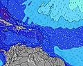 | 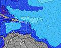 | 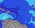 | 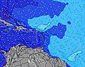 | ||||||||||||||
Wave Height (m) Direction Period (s) | NE 6 | NNE 4 | NE 6 | NE 5 | ENE 4 | NE 5 | N 9 | N 11 | NE 6 | NE 6 | NE 6 | NNE 9 | NE 8 | NNE 9 | NE 6 | NNE 6 | NNE 6 | NNE 9 | NNE 9 | NE 5 | NE 5 |
Wave Graph | |||||||||||||||||||||
0 | 4 | 0 | 0 | 0 | 0 | 2 | 3 | 0 | 0 | 0 | 8 | 0 | 8 | 0 | 27 | 4 | 8 | 7 | 0 | 0 | |
Wind (km/h) | |||||||||||||||||||||
Wind State on-shore cross-onshore cross-shore cross-offshore off-shore glassy | glassy | cross-off | off | glassy | cross-off | off | glassy | glassy | off | glassy | cross-off | cross-off | glassy | glassy | off | glassy | cross-off | off | on | cross-off | off |
High Tide | 12:17PM0.45m | 00:03AM0.42m | 1:11PM0.47m | 00:39AM0.38m | 2:09PM0.49m | 1:20AM0.34m | 3:11PM0.51m | 2:09AM0.31m | 4:16PM0.53m | 3:10AM0.29m | 5:20PM0.56m | 4:20AM0.28m | 6:21PM0.58m | ||||||||
Low Tide | 6:15PM0.19m | 6:26AM0.10m | 7:18PM0.21m | 7:03AM0.07m | 8:31PM0.22m | 7:47AM0.05m | 9:51PM0.22m | 8:39AM0.03m | 11:10PM0.22m | 9:39AM0.01m | 00:17AM0.20m | 10:44AM-0.00m | 1:12AM0.19m | ||||||||
6:07 | — | — | 6:07 | — | — | 6:07 | — | — | 6:07 | — | — | 6:07 | — | — | 6:07 | — | — | 6:09 | — | — | |
— | 7:01 | — | — | 7:01 | — | — | 7:00 | — | — | 7:00 | — | — | 7:00 | — | — | 7:00 | — | — | 6:59 | — | |
mm | — | — | — | — | 4 | 1 | — | 5 | 1 | — | 1 | — | — | — | — | 1 | — | — | — | 1 | — |
Temp °C | 29 | 29 | 28 | 28 | 29 | 28 | 28 | 28 | 28 | 28 | 29 | 28 | 27 | 28 | 27 | 28 | 29 | 28 | 28 | 29 | 28 |
Feels °C | 33 | 31 | 30 | 32 | 33 | 29 | 33 | 32 | 31 | 32 | 31 | 31 | 31 | 32 | 27 | 32 | 31 | 31 | 31 | 29 | 29 |
Swell 1 Height (m) Direction Period (s) | NE 6 | S 5 | NE 6 | S 5 | S 5 | S 5 | S 5 | S 5 | NE 6 | NE 6 | S 6 | NE 6 | NE 8 | NE 8 | NE 9 | NNE 6 | S 5 | NNE 9 | NNE 9 | NE 9 | NE 9 |
23 | 2 | 23 | 2 | 2 | 2 | 2 | 2 | 20 | 19 | 2 | 39 | 57 | 20 | 12 | 27 | 1 | 8 | 7 | 12 | 12 | |
Swell 2 Height (m) Direction Period (s) | S 6 | NNE 4 | S 5 | — | S 9 | — | N 9 | N 9 | S 5 | S 5 | NE 10 | NNE 9 | S 8 | NNE 9 | S 6 | NNE 9 | S 8 | S 5 | — | — | S 5 |
2 | 4 | 2 | — | 2 | — | 2 | 2 | 2 | 2 | 4 | 8 | 5 | 8 | 2 | 8 | 1 | 2 | — | — | 2 | |
Swell 3 Height (m) Direction Period (s) | — | — | — | S 8 | S 8 | SSE 6 | SE 6 | N 11 | NE 8 | NE 10 | S 8 | S 5 | — | S 8 | S 8 | S 5 | NNE 6 | S 8 | N 12 | S 9 | S 9 |
— | — | — | 1 | 1 | 4 | 1 | 3 | 3 | 4 | 1 | 2 | — | 5 | 1 | 2 | 4 | 1 | 3 | 2 | 2 | |
Wind waves Height (m) Direction Period (s) | — | NE 6 | — | NE 5 | ENE 4 | NE 5 | NE 5 | NE 5 | — | — | NE 6 | — | — | NE 6 | NE 6 | — | NE 6 | NE 6 | NE 6 | NE 5 | NE 5 |
— | 43 | — | 10 | 22 | 17 | 10 | 14 | — | — | 46 | — | — | 30 | 46 | — | 76 | 59 | 26 | 51 | 35 | |
Nearest Offshore or Glassy | |||||||||||||||||||||
Distance (km) | 22 | 303 | 44 | 473 | 473 | 125 | 303 | 22 | 25 | 22 | 303 | 58 | 3 | 3 | 210 | 22 | 473 | 58 | 22 | 643 | 58 |
Best forecast wave conditions in Puerto Rico | |||||||||||||||||||||
Best forecast wave conditions in Puerto Rico | |||||||||||||||||||||
Header Global | |||||||||||||||||||||
- Map Icons:
 Break
Break Live Wave Height (m)
 Live Wind Speed (km/h)
 Surf Rating (10 Max)
 Ocean Swells (m)
- Wind Speed (km/h)
Latest Updates


FREE! Surf-Forecast.com widget for your website
The surf report / weather widget below is available to embed on third party websites free of charge and provides a summary of our Dogmans (Rincon) surf forecast. Simply grab the html code snippet that we provide and paste it into your own site. You can choose your preferred language and metric/imperial units for the surf forecast feed to suit users of your site. Click here to get the code.
Information about the Dogmans (Rincon) Surf forecast
The above surf forecast table for Dogmans (Rincon) provides essential information for determining whether the surfing conditions will be good over the next 16 days. A general guide to surfing at Dogmans (Rincon) can be found by selecting the local surf guide option on the grey menu. Our Dogmans (Rincon) surf forecast is unique since it includes wave energy (power) that defines the real feel of the surf rather than just the height or the period. If you surf the same spot (Dogmans (Rincon)) regularly then make a mental note of the wave energy from the surf forecast table each time you go. Very soon you may start to choose your surf days based on the wave energy alone combined with our forecast of favourable offshore wind conditions. Our star ratings will help here and of course you will also find the usual wave height and period predictions on our surf forecasts as well as a full break down of the swell components under our advanced users option (to reveal that, click the little Einstein character under the tide times).
Further information to help with frequently asked questions about our surf forecast for Dogmans (Rincon) may be found under the help tab on the top menu and also by moving your mouse over the question marks on the surf forecast table itself. Please always bear in mind that the forecast is for near-shore open water and local factors at each surf break influence the actual breaking wave height, such as the beach / reef profile, water depths offshore and shelter.
 Nearest