

Surf Forecasts:

| Time (+04) & Date | Wave Height | Wave Period |
|---|---|---|
| Morning (22 Jul) | 0.5ft (0.1m) | 14s |
| Afternoon (22 Jul) | 0.5ft (0.1m) | 13s |
| Evening (22 Jul) | 0.5ft (0.1m) | 10s |
Table - waves today at Carana. (Swell directed towards the surf break)
Short Range ForecastSome drizzle, heaviest during Thu night. Warm (max 26°C on Wed morning, min 25°C on Thu night). Mainly fresh winds. | ||||||||||||||||||||||||
Wednesday 22 | Thursday 23 | Friday 24 | ||||||||||||||||||||||
1 AM | 4 AM | 7 AM | 10 AM | 1 PM | 4 PM | 7 PM | 10 PM | 1 AM | 4 AM | 7 AM | 10 AM | 1 PM | 4 PM | 7 PM | 10 PM | 1 AM | 4 AM | 7 AM | 10 AM | 1 PM | 4 PM | 7 PM | 10 PM | |
Swell Height Map | 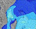 | 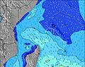 | 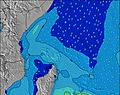 | 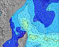 | 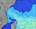 | 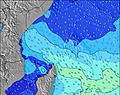 | 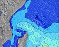 | 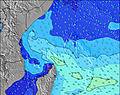 | 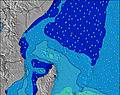 | |||||||||||||||
Wave Height (m) Direction Period (s) | SE 7 | NE 10 | SE 6 | W 14 | NE 10 | W 13 | NE 10 | NE 10 | NE 10 | NE 10 | W 13 | W 13 | W 13 | NE 10 | SE 8 | SE 8 | NE 10 | W 12 | NE 10 | NE 10 | NE 10 | NE 10 | SE 8 | NE 10 |
Wave Graph | ||||||||||||||||||||||||
0 | 4 | 0 | 4 | 4 | 4 | 4 | 4 | 4 | 4 | 4 | 3 | 4 | 4 | 0 | 0 | 4 | 3 | 4 | 4 | 4 | 4 | 0 | 4 | |
Wind (km/h) | ||||||||||||||||||||||||
Wind State on-shore cross-onshore cross-shore cross-offshore off-shore glassy | cross-off | cross-off | cross-off | cross-off | cross-off | cross-off | cross-off | cross-off | cross-off | cross-off | cross-off | cross-off | cross-off | cross-off | cross-off | cross-off | cross-off | cross-off | cross-off | off | cross-off | cross-off | off | off |
High Tide | 10:45AM1.15m | 10:17PM0.71m | 11:50AM1.12m | 11:43PM0.61m | 1:03PM1.11m | |||||||||||||||||||
Low Tide | 3:40AM0.27m | 5:43PM0.51m | 4:21AM0.34m | 7:24PM0.49m | 5:18AM0.40m | 8:48PM0.41m | ||||||||||||||||||
— | 6:26 | — | — | — | — | — | — | — | 6:26 | — | — | — | — | — | — | — | 6:26 | — | — | — | — | — | — | |
— | — | — | — | — | 6:21 | — | — | — | — | — | — | — | 6:21 | — | — | — | — | — | — | — | 6:21 | — | — | |
mm | — | — | — | — | — | — | — | — | — | — | — | — | — | — | — | — | 1 | — | — | — | — | — | — | — |
Temp °C | 26 | 26 | 26 | 26 | 26 | 26 | 26 | 26 | 26 | 26 | 26 | 26 | 26 | 26 | 26 | 25 | 25 | 25 | 25 | 25 | 26 | 26 | 26 | 25 |
Feels °C | 26 | 25 | 25 | 25 | 25 | 25 | 25 | 24 | 23 | 24 | 24 | 23 | 23 | 25 | 25 | 25 | 24 | 22 | 22 | 22 | 23 | 23 | 24 | 24 |
Swell 1 Height (m) Direction Period (s) | SSW 15 | SSW 14 | SSW 14 | SSW 13 | SSW 13 | SSW 14 | SSW 13 | SSW 13 | SSW 13 | SSW 13 | S 12 | S 12 | S 12 | SSW 12 | S 12 | SE 8 | SE 8 | S 12 | S 12 | S 11 | S 14 | S 13 | S 13 | S 13 |
123 | 163 | 145 | 141 | 141 | 143 | 135 | 135 | 137 | 135 | 151 | 148 | 151 | 162 | 148 | 346 | 288 | 144 | 144 | 91 | 132 | 127 | 125 | 222 | |
Swell 2 Height (m) Direction Period (s) | ESE 9 | SSE 15 | SSE 14 | SSE 15 | SSE 14 | SSE 14 | SSE 14 | SSE 14 | SSE 13 | SSE 13 | NE 10 | W 13 | NE 10 | SSE 13 | SSE 13 | S 12 | S 12 | SSW 15 | SSW 15 | S 14 | SSW 11 | SSW 11 | SSW 10 | SE 14 |
29 | 42 | 41 | 47 | 38 | 66 | 38 | 37 | 35 | 35 | 4 | 3 | 4 | 18 | 18 | 146 | 187 | 21 | 21 | 103 | 39 | 40 | 20 | 7 | |
Swell 3 Height (m) Direction Period (s) | SSE 15 | NE 10 | S 9 | W 14 | NE 10 | W 13 | NE 10 | NE 10 | NE 10 | NE 10 | W 13 | — | W 13 | NE 10 | S 16 | S 16 | NE 10 | W 12 | NE 10 | NE 10 | NE 10 | NE 10 | SE 14 | NE 10 |
44 | 4 | 2 | 4 | 4 | 4 | 4 | 4 | 4 | 4 | 3 | — | 3 | 4 | 5 | 5 | 4 | 3 | 4 | 4 | 4 | 4 | 7 | 4 | |
Wind waves Height (m) Direction Period (s) | SE 7 | SE 9 | SE 6 | ESE 6 | ESE 7 | ESE 8 | ESE 8 | ESE 8 | ESE 8 | ESE 8 | ESE 8 | SE 8 | SE 8 | SE 8 | SE 8 | — | — | SE 8 | SE 8 | SE 8 | SE 8 | SE 8 | SE 8 | SE 8 |
194 | 349 | 196 | 222 | 266 | 374 | 403 | 413 | 413 | 374 | 383 | 410 | 372 | 372 | 372 | — | — | 338 | 423 | 448 | 428 | 401 | 375 | 375 | |
Nearest Offshore or Glassy | ||||||||||||||||||||||||
Distance (km) | 1731 | 1731 | 1731 | 1731 | 1731 | 1731 | 1731 | 1731 | 1731 | 1731 | 1731 | 1731 | 1731 | 20 | 1731 | 1731 | 1731 | 1731 | 1731 | 1741 | 1770 | 1770 | 1741 | 1770 |
Best forecast wave conditions in Mahe | ||||||||||||||||||||||||
Best forecast wave conditions in Seychelles | ||||||||||||||||||||||||
Header Global | ||||||||||||||||||||||||
- Map Icons:
 Break
Break Live Wave Height (m)
 Live Wind Speed (km/h)
 Surf Rating (10 Max)
 Ocean Swells (m)
- Wind Speed (km/h)


FREE! Surf-Forecast.com widget for your website
The surf report / weather widget below is available to embed on third party websites free of charge and provides a summary of our Carana surf forecast. Simply grab the html code snippet that we provide and paste it into your own site. You can choose your preferred language and metric/imperial units for the surf forecast feed to suit users of your site. Click here to get the code.
 Nearest