

Surf Forecasts:

Anse aux Poules Bleues surf forecast from 4 Jul 2026:
- Best quality surf: Thursday 9 Jul, 1PM (local time) - 6ft (1.9m), 9s period, S swell with offshore winds.
- Most powerful swell: Tuesday 7 Jul, 1AM (local time) - 8ft (2.4m), 9s period, SE swell with 910 kJ wave energy.
- Next surfable swell (1★+): Sunday 5 Jul, 1AM (local time) - 4.5ft (1.3m), 9s period with SSE swell.
Best Forecast Surf Conditions for Anse aux Poules Bleues this week:
The surf forecast for Anse aux Poules Bleues over the next 16 days: The first swell (rated 1 star or higher) is forecast to arrive on Sunday (Jul 05) at 1AM. The primary swell is predicted to be 1.3m and 9s period with a secondary swell of 0.5m and 10s. The wind is predicted to be offshore as the swell arrives.
The most powerful waves expected at Anse aux Poules Bleues in the next 16 days are 2.4m 9s and forecast to arrive on Tuesday (Jul 07) at 1AM. Winds are predicted to be offshore at the time the swell arrives. The largest open ocean swell (not directed at the beach) is 0.5m 3s period and expected on Sunday (Jul 05) at 10AM.
| Wave Type | Time (+04) & Date | Wave Height & Period |
|---|---|---|
| Next good surf (1 star+) | 1AM (Sun 5th Jul) | 4.5ft (1.3m) 9s |
| Best Surf | 1PM (Thu 9th Jul) | 6ft (1.9m) 9s |
| Most Powerful | 1AM (Tue 7th Jul) | 8ft (2.4m) 9s |
Table - best surf conditions forecast for Anse aux Poules Bleues over the next 16 days.
Updates in hr min s Forecast update imminent
Alright crew, Rusty here with a look at the surf ahead for Anse aux Poules Bleues. It’s a reef set-up that’s pretty inconsistent and can draw a crowd sometimes, so keep that in mind. The water temp is sitting about average for this time of year.
Right now, we’re looking at a bit of a rough start. The good news is we’ve got clean, offshore winds locked in for the whole run, but the swell quality is all over the place. The first few days are a write-off for anything decent. Sunday the 5th has a bit of 4ft to 6ft SSE swell but the wave energy is weak to moderate and the conditions are just poor. You won’t be missing much.
Monday the 6th and Tuesday the 7th see the swell jump up to the 7ft to 8ft range with moderate energy, but the wind is howling at 22 mph and while it’s offshore, it’s too fresh to be fun. The surf quality scores are poor to marginal at best.
The first real hint of something half-decent creeps in on Thursday the 9th. The morning is still ordinary, but by Thursday afternoon we’ve got a 6ft S swell with a period of 10 seconds and moderate energy. The wind drops to a moderate 12 mph offshore. It’s not perfect, but it’s the best on offer so far. Friday the 10th morning looks similar with a 7ft SSE swell and the same 10-second period, but the wind picks up again.
The standout window, if you can call it that, is shaping up for Sunday the 19th into Monday the 20th. It’s a long way out, so treat it with caution, but Sunday afternoon shows a 7ft SSE groundswell with a nice 11-second period and strong energy. Monday morning then pushes up to 8ft SE swell with 10-second period and very strong energy. Now, the catch is that 8ft is getting into expert-only territory, especially for a reef break. The period is decent, not overly long, so it should hold shape better than a beach break. A fresh 19 mph offshore wind will keep it clean, but it’ll be a battle out there. Keep an eye on it.
Overall, there’s no real gem in this 16-day run. The most reliable session is probably Thursday afternoon the 9th or Friday morning the 10th for a fun, clean wave in the chest-to-head high range. The late period swell on the 19th-20th has the most power, but it’s a long-range call and the size will sort the men from the boys.
Rusty.
Short Range ForecastMostly dry. Warm (max 26°C on Sun afternoon, min 25°C on Sat night). Winds increasing (light winds from the SSE on Sat night, strong winds from the SSE by Mon night). | Days 5-7 Weather SummaryMostly dry. Warm (max 25°C on Tue night, min 24°C on Tue night). Mainly fresh winds. | ||||||||||||||||||||
Sunday 5 | Monday 6 | Tuesday 7 | Wednesday 8 | Thursday 9 | Friday 10 | Sat 11 | |||||||||||||||
Night | AM | PM | Night | AM | PM | Night | AM | PM | Night | AM | PM | Night | AM | PM | Night | AM | PM | Night | AM | PM | |
Swell Height Map | 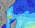 | 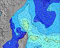 | 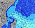 | 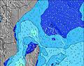 | 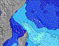 | 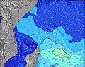 | 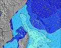 | 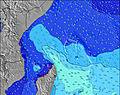 | |||||||||||||
Wave Height (m) Direction Period (s) | SSE 9 | SSE 9 | SSE 9 | SE 9 | SE 8 | SSE 9 | SE 9 | SSE 8 | SSE 8 | SSE 8 | S 8 | S 8 | SSW 9 | S 9 | S 10 | S 10 | SSE 10 | S 10 | S 10 | S 10 | SSE 10 |
Wave Graph | |||||||||||||||||||||
266 | 207 | 486 | 631 | 719 | 732 | 910 | 699 | 621 | 589 | 576 | 465 | 333 | 575 | 768 | 745 | 804 | 586 | 541 | 468 | 394 | |
Wind (km/h) | |||||||||||||||||||||
Wind State on-shore cross-onshore cross-shore cross-offshore off-shore glassy | off | off | off | off | off | off | off | off | off | off | off | off | off | off | off | off | off | off | off | off | off |
High Tide | 8:09AM1.02m | 7:51PM1.19m | 8:49AM1.06m | 8:27PM1.09m | 9:35AM1.11m | 9:11PM0.96m | 10:28AM1.17m | 10:07PM0.83m | 11:30AM1.22m | 11:23PM0.72m | 12:39PM1.30m | 00:58AM0.66m | 1:48PM1.38m | ||||||||
Low Tide | 1:59AM0.15m | 1:45PM0.41m | 2:28AM0.18m | 2:36PM0.45m | 2:58AM0.21m | 3:40PM0.48m | 3:34AM0.24m | 5:00PM0.49m | 4:18AM0.26m | 6:33PM0.44m | 5:16AM0.28m | 7:59PM0.35m | 6:27AM0.27m | ||||||||
— | 6:26 | — | — | 6:26 | — | — | 6:26 | — | — | 6:26 | — | — | 6:26 | — | — | 6:26 | — | — | 6:26 | — | |
— | — | 6:17 | — | — | 6:17 | — | — | 6:17 | — | — | 6:17 | — | — | 6:19 | — | — | 6:19 | — | — | 6:19 | |
mm | — | — | — | — | — | — | — | — | — | — | — | — | — | — | — | — | — | — | — | — | — |
Temp °C | 25 | 25 | 26 | 25 | 25 | 26 | 25 | 25 | 25 | 25 | 25 | 25 | 25 | 25 | 25 | 25 | 25 | 25 | 25 | 25 | 25 |
Feels °C | 27 | 25 | 26 | 24 | 22 | 24 | 23 | 22 | 22 | 22 | 24 | 24 | 24 | 26 | 26 | 25 | 26 | 27 | 27 | 27 | 27 |
Swell 1 Height (m) Direction Period (s) | SSE 9 | SSE 9 | S 15 | S 14 | SSW 14 | E 8 | SSW 15 | E 10 | E 10 | ESE 9 | ESE 9 | S 8 | SSW 9 | S 9 | S 10 | S 10 | SSE 10 | S 10 | S 10 | S 10 | SSE 10 |
266 | 207 | 115 | 107 | 63 | 173 | 74 | 188 | 148 | 106 | 108 | 465 | 333 | 575 | 768 | 745 | 804 | 586 | 541 | 468 | 394 | |
Swell 2 Height (m) Direction Period (s) | E 10 | ESE 9 | S 15 | S 16 | — | SSW 13 | N 11 | SSW 14 | SSW 14 | S 15 | S 15 | ESE 9 | ESE 9 | ESE 9 | ESE 8 | ESE 8 | ESE 9 | ESE 8 | ESE 10 | ESE 9 | ESE 10 |
48 | 47 | 112 | 5 | — | 33 | 2 | 70 | 62 | 112 | 163 | 132 | 132 | 82 | 96 | 92 | 168 | 127 | 152 | 124 | 128 | |
Swell 3 Height (m) Direction Period (s) | SSW 17 | SSW 16 | — | — | — | SSW 16 | — | N 11 | E 16 | SSW 10 | E 16 | S 14 | S 13 | — | ESE 14 | ESE 12 | — | — | S 21 | S 20 | S 19 |
59 | 89 | — | — | — | 48 | — | 2 | 5 | 10 | 5 | 264 | 222 | — | 18 | 30 | — | — | 9 | 7 | 27 | |
Wind waves Height (m) Direction Period (s) | — | S 3 | SSE 9 | SE 9 | SE 8 | SSE 9 | SE 9 | SSE 8 | SSE 8 | SSE 8 | S 8 | — | SSE 8 | — | — | — | — | — | — | — | — |
— | 6 | 486 | 631 | 719 | 732 | 910 | 699 | 621 | 589 | 576 | — | 179 | — | — | — | — | — | — | — | — | |
Nearest Offshore or Glassy | |||||||||||||||||||||
Distance (km) | 0 | 1711 | 0 | 1711 | 1711 | 1795 | 1793 | 1801 | 1801 | 1795 | 1795 | 1795 | 1795 | 0 | 0 | 0 | 0 | 0 | 0 | 0 | 0 |
Best forecast wave conditions in Mahe | |||||||||||||||||||||
Best forecast wave conditions in Seychelles | |||||||||||||||||||||
Header Global | |||||||||||||||||||||
- Map Icons:
 Break
Break Live Wave Height (m)
 Live Wind Speed (km/h)
 Surf Rating (10 Max)
 Ocean Swells (m)
- Wind Speed (km/h)


FREE! Surf-Forecast.com widget for your website
The surf report / weather widget below is available to embed on third party websites free of charge and provides a summary of our Anse aux Poules Bleues surf forecast. Simply grab the html code snippet that we provide and paste it into your own site. You can choose your preferred language and metric/imperial units for the surf forecast feed to suit users of your site. Click here to get the code.
Information about the Anse aux Poules Bleues Surf forecast
The above surf forecast table for Anse aux Poules Bleues provides essential information for determining whether the surfing conditions will be good over the next 16 days. A general guide to surfing at Anse aux Poules Bleues can be found by selecting the local surf guide option on the grey menu. Our Anse aux Poules Bleues surf forecast is unique since it includes wave energy (power) that defines the real feel of the surf rather than just the height or the period. If you surf the same spot (Anse aux Poules Bleues) regularly then make a mental note of the wave energy from the surf forecast table each time you go. Very soon you may start to choose your surf days based on the wave energy alone combined with our forecast of favourable offshore wind conditions. Our star ratings will help here and of course you will also find the usual wave height and period predictions on our surf forecasts as well as a full break down of the swell components under our advanced users option (to reveal that, click the little Einstein character under the tide times).
Further information to help with frequently asked questions about our surf forecast for Anse aux Poules Bleues may be found under the help tab on the top menu and also by moving your mouse over the question marks on the surf forecast table itself. Please always bear in mind that the forecast is for near-shore open water and local factors at each surf break influence the actual breaking wave height, such as the beach / reef profile, water depths offshore and shelter.
Are you planning a holiday in Mahe? If you are looking for accommodation near Anse aux Poules Bleues, camping, hotels and holiday cottages in Mahe, consider staying in Victoria which is 13 km (8 miles) away.
 Nearest