

Surf Forecasts:

Triggs Beach Adelaide surf forecast from 2 Aug 2026:
- Most powerful swell: Saturday 8 Aug, 6PM (local time) - 6ft (1.9m), 6s period, NNW swell with 222 kJ wave energy.
Best Forecast Surf Conditions for Triggs Beach Adelaide this week:
The most powerful waves expected at Triggs Beach Adelaide in the next 16 days are 1.9m 6s and forecast to arrive on Saturday (Aug 08) at 6PM. Winds are predicted to be cross-shore at the time the swell arrives. The largest open ocean swell (not directed at the beach) is 2.4m 7s period and expected on Sunday (Aug 09) at 9AM.
| Wave Type | Time (ACST) & Date | Wave Height & Period |
|---|---|---|
| Next good surf (1 star+) | - | - |
| Best Surf | - | - |
| Most Powerful | 6PM (Sat 8th Aug) | 6ft (1.9m) 6s |
Table - best surf conditions forecast for Triggs Beach Adelaide over the next 16 days.
The Lowdown
G’day, it’s Rusty here. Let’s be straight with you: the next couple of weeks are looking pretty bleak for a proper paddle on the South Coast. We’ve got a long stretch of small, weak surf and messy winds, so if you’re hanging out for a wave, you might be waiting a while. But don’t bin the board just yet – there’s a small window down the track that might just save the run.
We’re looking at Triggs Beach Adelaide, a sheltered reef break that needs a solid WSW swell to get going. The water temp is sitting about average for this time of year, so nothing wild there. For the first week, it’s a write-off. Monday the 3rd has a tiny 2ft cross-onshore chop, and it just gets smaller and more disorganised from there. The energy’s weak, with combined readings mostly in single digits or low teens, so it’s barely a ripple. Wednesday and Thursday are flat as a tack, with the odd 1ft to 1ft dribble, and cross-shore winds aren’t helping. Friday’s got a clean-looking light breeze but the swell’s gone – you’re looking at 0.3ft, so don’t even bother.
Then we hit the weekend of the 8th and 9th of August. Saturday afternoon kicks up a bit of a windswell to 5ft, but it’s accompanied by a strong 28 mph cross-shore and messy conditions. The energy jumps to 123, so there’s some push there, but it’s not for the faint-hearted and definitely not for a beginner – over 5ft is pushing it. Sunday’s just as ugly with a strong onshore breeze. Honestly, the setup looks more like a kite-surfing day than a surf day.
The middle of the following week, the 10th and 11th, sees a bit more life. Monday’s got 3ft from the WNW, but it’s cross-onshore and choppy. Tuesday the 11th has a more solid 5ft from the north, with the energy hitting 154, so there’s some proper power in the water. But the winds are still cross-shore, and the period’s a short 6 seconds, so it’s likely to be lumpy and uninviting. Still well under 8ft, so not an expert-only zone, but the quality just isn’t there.
Now, here’s the one to keep an eye on. Friday the 14th of August. The morning has a clean 6ft from the WNW with light offshore winds – that’s the best combo we’ve seen all run. The energy is up at 158, which is strong, and the conditions are finally glassy. It’s the standout of the fortnight, no question. A bit later in the afternoon, the swell drops to 5ft and goes glassy, which would still be fun, but the morning looks like the pick. It’s a reef, so that longer period would help, though it’s only 5 seconds here, so the shape might be a bit ordinary.
After that little highlight, it fades fast. The 15th and 16th drop right off, with tiny 0.3ft to 3ft leftovers and a clean but empty lineup. The 17th has a small 2ft from the west, but the winds turn messy again. By Tuesday the 18th, it’s flat.
So there you have it. Don’t rush out this week – it’s a dead loss. Keep your powder dry for Friday the 14th. That’s the one. It’s not a full-blown classic, but it’s the best we’ve got, and the clean conditions will make it worth the drive.
Rusty.
Short Range ForecastMostly dry. Very mild (max 13°C on Sun night, min 8°C on Tue night). Wind will be generally light. | Days 5-7 Weather SummaryLight rain (total 7mm), mostly falling on Sat morning. Very mild (max 17°C on Fri afternoon, min 10°C on Sat afternoon). Winds increasing (calm on Thu afternoon, strong winds from the N by Sat afternoon). | ||||||||||||||||||
Monday 3 | Tuesday 4 | Wednesday 5 | Thursday 6 | Friday 7 | Saturday 8 | ||||||||||||||
Night | AM | PM | Night | AM | PM | Night | AM | PM | Night | AM | PM | Night | AM | PM | Night | AM | PM | Night | |
Swell Height Map |  | 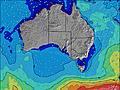 | 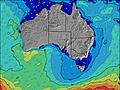 | 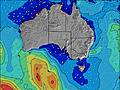 | 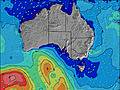 | 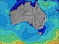 | 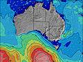 | ||||||||||||
Wave Height (m) Direction Period (s) | W 6 | WSW 5 | WSW 4 | WSW 4 | WSW 4 | WSW 8 | WSW 8 | W 7 | NNW 3 | W 7 | N 3 | NNW 3 | W 10 | SW 15 | N 4 | N 4 | N 4 | N 5 | W 5 |
Wave Graph | |||||||||||||||||||
127 | 27 | 14 | 10 | 5 | 0 | 0 | 0 | 2 | 0 | 3 | 1 | 0 | 9 | 8 | 7 | 0 | 119 | 27 | |
Wind (km/h) | |||||||||||||||||||
Wind State on-shore cross-onshore cross-shore cross-offshore off-shore glassy | on | cross-on | cross-on | cross-on | on | on | off | cross-off | cross | cross-off | cross | cross | off | cross | cross | cross | cross | cross | cross-on |
High Tide | 6:39AM1.97m | 6:38PM2.14m | 7:03AM2.05m | 7:04PM1.98m | 7:32AM2.07m | 7:30PM1.74m | 8:05AM2.01m | 7:51PM1.45m | 8:44AM1.88m | 7:41PM1.15m | 9:43AM1.69m | ||||||||
Low Tide | 00:33AM0.34m | 12:30PM0.50m | 00:52AM0.38m | 1:04PM0.52m | 1:12AM0.43m | 1:41PM0.61m | 1:31AM0.50m | 2:26PM0.77m | 1:45AM0.60m | 3:31PM0.97m | 1:37AM0.69m | 11:57PM0.69m | |||||||
— | 7:09 | — | — | 7:09 | — | — | 7:07 | — | — | 7:07 | — | — | 7:05 | — | — | 7:05 | — | — | |
— | — | 5:35 | — | — | 5:35 | — | — | 5:36 | — | — | 5:37 | — | — | 5:37 | — | — | 5:37 | — | |
mm | — | — | — | — | — | — | — | — | — | — | — | — | — | — | — | — | 4 | 3 | 8 |
Temp °C | 13 | 13 | 13 | 11 | 12 | 11 | 9 | 11 | 12 | 12 | 13 | 14 | 14 | 16 | 17 | 16 | 13 | 11 | 12 |
Feels °C | 7 | 8 | 9 | 7 | 9 | 8 | 7 | 7 | 9 | 9 | 9 | 12 | 12 | 11 | 14 | 12 | 6 | 3 | 4 |
Swell 1 Height (m) Direction Period (s) | S 18 | WSW 9 | WSW 9 | WSW 8 | WSW 8 | WSW 8 | WSW 8 | W 7 | W 7 | W 7 | — | — | W 4 | — | WSW 10 | SW 10 | — | W 8 | NNW 5 |
6 | 30 | 15 | 7 | 6 | 12 | 6 | 4 | 1 | 1 | — | — | 1 | — | 9 | 4 | — | 1 | 46 | |
Swell 2 Height (m) Direction Period (s) | — | — | — | — | SW 11 | — | — | — | — | — | — | — | W 10 | SW 15 | SW 15 | W 5 | W 10 | S 15 | SW 15 |
— | — | — | — | 5 | — | — | — | — | — | — | — | 2 | 9 | 8 | 1 | 2 | 4 | 8 | |
Swell 3 Height (m) Direction Period (s) | — | — | — | — | — | — | — | — | — | — | — | — | — | W 9 | — | S 15 | W 6 | — | — |
— | — | — | — | — | — | — | — | — | — | — | — | — | 2 | — | 4 | 1 | — | — | |
Wind waves Height (m) Direction Period (s) | W 6 | WSW 5 | WSW 4 | WSW 4 | WSW 4 | — | — | NNE 2 | NNW 3 | — | N 3 | NNW 3 | — | N 3 | N 4 | N 4 | N 4 | N 5 | W 5 |
127 | 27 | 14 | 10 | 4 | — | — | 1 | 2 | — | 3 | 1 | — | 3 | 6 | 7 | 19 | 119 | 27 | |
Nearest Offshore or Glassy | |||||||||||||||||||
Distance (km) | 448 | 611 | 612 | 128 | 45 | 128 | 44 | 44 | 44 | 44 | 44 | 44 | 44 | 44 | 44 | 44 | 44 | 617 | 782 |
Best forecast wave conditions in Adelaide | |||||||||||||||||||
Best forecast wave conditions in Australia | |||||||||||||||||||
Header Global | |||||||||||||||||||
- Map Icons:
 Break
Break Live Wave Height (m)
 Live Wind Speed (km/h)
 Surf Rating (10 Max)
 Ocean Swells (m)
- Wind Speed (km/h)
Latest Updates


FREE! Surf-Forecast.com widget for your website
The surf report / weather widget below is available to embed on third party websites free of charge and provides a summary of our Triggs Beach Adelaide surf forecast. Simply grab the html code snippet that we provide and paste it into your own site. You can choose your preferred language and metric/imperial units for the surf forecast feed to suit users of your site. Click here to get the code.
Information about the Triggs Beach Adelaide Surf forecast
The above surf forecast table for Triggs Beach Adelaide provides essential information for determining whether the surfing conditions will be good over the next 16 days. A general guide to surfing at Triggs Beach Adelaide can be found by selecting the local surf guide option on the grey menu. Our Triggs Beach Adelaide surf forecast is unique since it includes wave energy (power) that defines the real feel of the surf rather than just the height or the period. If you surf the same spot (Triggs Beach Adelaide) regularly then make a mental note of the wave energy from the surf forecast table each time you go. Very soon you may start to choose your surf days based on the wave energy alone combined with our forecast of favourable offshore wind conditions. Our star ratings will help here and of course you will also find the usual wave height and period predictions on our surf forecasts as well as a full break down of the swell components under our advanced users option (to reveal that, click the little Einstein character under the tide times).
Further information to help with frequently asked questions about our surf forecast for Triggs Beach Adelaide may be found under the help tab on the top menu and also by moving your mouse over the question marks on the surf forecast table itself. Please always bear in mind that the forecast is for near-shore open water and local factors at each surf break influence the actual breaking wave height, such as the beach / reef profile, water depths offshore and shelter.
Triggs Beach is 9 km (6 miles) from the very large city of Morphett Vale. If you plan a holiday in Adelaide, look for hotels and other accommodation in Morphett Vale. Morphett Vale has rooms for a wide range of budgets as well as cheap car hire and transport links.
 Nearest