

Surf Forecasts:

Ticla surf forecast from 30 Jul 2026:
- Best quality surf: Thursday 30 Jul, 6PM (local time) - 4.5ft (1.3m), 14s period, SSW swell with glassy winds.
- Most powerful swell: Thursday 30 Jul, 6PM (local time) - 4.5ft (1.3m), 14s period, SSW swell with 692 kJ wave energy.
- Next surfable swell (1★+): Thursday 30 Jul, 6PM (local time) - 4.5ft (1.3m), 14s period with SSW swell.
Best Forecast Surf Conditions for Ticla this week:
The surf forecast for Ticla over the next 16 days: The first swell (rated 1 star or higher) is forecast to arrive on Thursday (Jul 30) at 6PM. The primary swell is predicted to be 1.3m and 14s period with a secondary swell of 0.8m and 10s. The wind is predicted to be glassy as the swell arrives.
The most powerful waves expected at Ticla in the next 16 days are 1.3m 14s and forecast to arrive on Thursday (Jul 30) at 6PM. Winds are predicted to be glassy at the time the swell arrives. The largest open ocean swell (not directed at the beach) is 0.5m 9s period and expected on Saturday (Aug 01) at 3AM.
| Wave Type | Time (CST) & Date | Wave Height & Period |
|---|---|---|
| Next good surf (1 star+) | 6PM (Thu 30th Jul) | 4.5ft (1.3m) 14s |
| Best Surf | 6PM (Thu 30th Jul) | 4.5ft (1.3m) 14s |
| Most Powerful | 6PM (Thu 30th Jul) | 4.5ft (1.3m) 14s |
Table - best surf conditions forecast for Ticla over the next 16 days.
The Lowdown
Alright, Rusty here, and I’ve been digging into the forecast for the next couple of weeks. It’s a slow start, but there’s a real gem of a session if you’re willing to wait.
We’re looking at Ticla for the entire run. It’s a classic point break, wide open to the south swell. The water is sitting at 88° – a touch warmer than normal for this time of year, so you’ll be fine in a shorty or just boardies.
The action kicks off on Thursday, July 30th with a solid pulse. First thing in the morning, it’s glassy – dead calm. We’ve got a 5ft SSW groundswell, with a very long 14-second period, and the combined energy is a solid (1042). That’s moderate energy, but it’s got some punch. This is clean, powerful stuff for experienced surfers; beginners will find it a lot to handle. The afternoon goes onshore and messy, so be there at dawn.
Friday the 31st sees the swell ease to 4ft, but again, a glassy morning with clean, long-period lines. The locals will be out. Saturday and Sunday drop into the 3ft range, with the wind turning cross-offshore Saturday morning – still clean, but smaller. The afternoons are blown out by a westerly, so the window is the mornings only.
From the 3rd of August onward, the swell drops right off, down to 2ft or 2ft, and we hit a real lull. The energy drops to (152). It’s surfable, but pretty ordinary. You’ll be working for scraps. This lull lasts a solid four days, until the 6th of August.
Then, things start to shift. On Thursday, August 6th, we see a new SSW swell pushing in at 2ft, but the period is a massive 18 seconds. That’s a long-period groundswell, and the energy jumps to (501). The glassy morning is the pick.
The real standout, the one you need to save the date for, is Friday, August 7th (morning) . The swell jumps to 4ft, still from the SSW, with that same long 18-second period. The combined energy is pumping at (974) – that’s strong wave energy. The wind is a clean cross-offshore from the east, and the call is for “very good surf conditions.” This is the best session on offer. The long period will make it a bit racy, but for a point like Ticla, it’s going to produce some long, lined-up walls. The crowd factor is listed as “sometimes,” so expect a few people.
The next few mornings after that keep offering clean, 4ft SSW swell, with good energy readings in the 800s and 900s, but the wind gets a bit more on it. The mornings of the 8th, 9th, and 10th still look good, with the 10th of August morning having a cross-off breeze and solid energy (551). The afternoon of the 10th is a glassy 2ft swell, but with a 20-second period – that’s an incredibly long wait between sets, more of a novelty.
The second week settles into a pattern: 4ft SW swell, with glassy or cross-off mornings. The 12th, 13th, and 14th of August mornings all look clean and promising. The energy stays in the moderate-to-strong range (549 to 879). It won’t be as big as the 7th, but it’ll be consistent and fun. The afternoons are largely a washout with onshore winds.
So, the call is this: if you can only get out one day, make it Friday, August 7th, first light. That’s the pick of the whole run. The rest of the mornings are good, but that one is a standout. Rusty, signing off.
Short Range ForecastMostly dry. Warm (max 30°C on Thu afternoon, min 27°C on Thu night). Wind will be generally light. | Days 4-6 Weather SummaryLight rain (total 4mm), mostly falling on Sun night. Warm (max 30°C on Sun morning, min 27°C on Tue night). Wind will be generally light. | ||||||||||||||||||||
Thursday 30 | Friday 31 | Saturday 1 | Sunday 2 | Monday 3 | Tuesday 4 | Wednesday 5 | |||||||||||||||
AM | PM | Night | AM | PM | Night | AM | PM | Night | AM | PM | Night | AM | PM | Night | AM | PM | Night | AM | PM | Night | |
Swell Height Map |  |  |  | 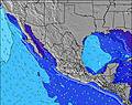 | 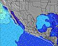 | 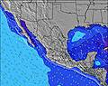 | 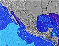 | ||||||||||||||
Wave Height (m) Direction Period (s) | SSW 14 | SSW 14 | SSW 14 | SSW 13 | SSW 13 | SSW 13 | SSW 13 | SSW 13 | SW 14 | SW 14 | SSW 13 | SSW 13 | SSW 13 | SSW 13 | SSW 13 | SSW 12 | SSW 12 | SW 15 | SW 14 | SW 14 | SW 14 |
Wave Graph | |||||||||||||||||||||
874 | 752 | 586 | 536 | 408 | 302 | 257 | 261 | 195 | 147 | 273 | 265 | 261 | 141 | 99 | 85 | 96 | 134 | 132 | 128 | 149 | |
Wind (km/h) | |||||||||||||||||||||
Wind State on-shore cross-onshore cross-shore cross-offshore off-shore glassy | glassy | on | cross-off | glassy | cross-on | cross-off | cross-off | cross-on | cross | glassy | cross-on | cross | cross | cross-on | cross | glassy | cross-on | cross-off | cross-off | cross-on | cross-off |
High Tide | 11:03AM0.59m | 9:19PM0.68m | 11:12AM0.59m | 9:41PM0.66m | 11:18AM0.59m | 10:05PM0.62m | 11:20AM0.60m | 10:28PM0.56m | 11:19AM0.60m | 10:48PM0.48m | 11:12AM0.61m | 10:19PM0.39m | 10:49AM0.62m | ||||||||
Low Tide | 3:44PM0.44m | 4:22AM0.14m | 4:05PM0.42m | 4:35AM0.19m | 4:30PM0.40m | 4:45AM0.25m | 5:03PM0.38m | 4:49AM0.31m | 5:46PM0.37m | 4:30AM0.37m | 7:02PM0.37m | 00:40AM0.28m | |||||||||
6:30 | — | — | 6:31 | — | — | 6:31 | — | — | 6:31 | — | — | 6:31 | — | — | 6:31 | — | — | 6:31 | — | — | |
— | 7:28 | — | — | 7:28 | — | — | 7:28 | — | — | 7:27 | — | — | 7:27 | — | — | 7:25 | — | — | 7:25 | — | |
mm | — | — | — | — | — | — | — | — | — | — | — | 1 | — | — | — | — | 1 | 2 | 2 | 1 | — |
Temp °C | 29 | 30 | 28 | 30 | 30 | 29 | 30 | 30 | 29 | 30 | 30 | 29 | 30 | 30 | 29 | 30 | 30 | 29 | 29 | 30 | 29 |
Feels °C | 32 | 34 | 32 | 34 | 33 | 32 | 32 | 32 | 31 | 34 | 33 | 32 | 34 | 34 | 33 | 35 | 35 | 33 | 33 | 34 | 35 |
Swell 1 Height (m) Direction Period (s) | SSW 14 | SSW 14 | SSW 14 | SSW 13 | SSW 13 | SSW 13 | SSW 13 | SSW 13 | SSW 12 | W 6 | SSW 13 | SSW 13 | SSW 13 | SSW 13 | SSW 13 | SSW 12 | SSW 12 | S 8 | SW 14 | S 9 | SW 14 |
874 | 752 | 586 | 536 | 408 | 302 | 257 | 261 | 145 | 40 | 273 | 265 | 261 | 141 | 99 | 85 | 96 | 46 | 132 | 56 | 149 | |
Swell 2 Height (m) Direction Period (s) | W 10 | W 10 | W 10 | W 10 | W 9 | W 9 | W 8 | SW 15 | SW 14 | SSW 12 | W 6 | SW 18 | W 5 | W 5 | W 5 | S 11 | S 8 | SW 15 | S 7 | SW 14 | S 9 |
130 | 141 | 106 | 66 | 41 | 38 | 36 | 136 | 195 | 147 | 32 | 80 | 20 | 13 | 10 | 61 | 33 | 134 | 17 | 128 | 56 | |
Swell 3 Height (m) Direction Period (s) | SSE 11 | SSE 11 | SSE 10 | SSE 9 | SW 16 | SW 16 | SW 15 | W 8 | SW 19 | SW 14 | SW 18 | W 9 | SW 16 | SW 12 | SW 16 | W 4 | SW 15 | SW 12 | S 9 | SW 11 | SW 20 |
38 | 22 | 18 | 15 | 42 | 90 | 109 | 22 | 58 | 114 | 49 | 14 | 69 | 52 | 91 | 6 | 77 | 36 | 27 | 31 | 97 | |
Wind waves Height (m) Direction Period (s) | — | — | — | — | — | — | NW 3 | WNW 3 | WNW 5 | WNW 6 | WNW 6 | W 5 | — | — | W 4 | — | — | WNW 5 | — | SE 3 | — |
— | — | — | — | — | — | 5 | 3 | 29 | 58 | 47 | 27 | — | — | 19 | — | — | 7 | — | 3 | — | |
Nearest Offshore or Glassy | |||||||||||||||||||||
Distance (km) | 0 | 327 | 0 | 0 | 351 | 0 | 0 | 847 | 44 | 0 | 355 | 66 | 4 | 844 | 4 | 0 | 237 | 0 | 0 | 356 | 0 |
Best forecast wave conditions in Michoacan | |||||||||||||||||||||
Best forecast wave conditions in Mexico | |||||||||||||||||||||
Header Global | |||||||||||||||||||||
- Map Icons:
 Break
Break Live Wave Height (m)
 Live Wind Speed (km/h)
 Surf Rating (10 Max)
 Ocean Swells (m)
- Wind Speed (km/h)
Latest Updates


FREE! Surf-Forecast.com widget for your website
The surf report / weather widget below is available to embed on third party websites free of charge and provides a summary of our Ticla surf forecast. Simply grab the html code snippet that we provide and paste it into your own site. You can choose your preferred language and metric/imperial units for the surf forecast feed to suit users of your site. Click here to get the code.
Information about the Ticla Surf forecast
The above surf forecast table for Ticla provides essential information for determining whether the surfing conditions will be good over the next 16 days. A general guide to surfing at Ticla can be found by selecting the local surf guide option on the grey menu. Our Ticla surf forecast is unique since it includes wave energy (power) that defines the real feel of the surf rather than just the height or the period. If you surf the same spot (Ticla) regularly then make a mental note of the wave energy from the surf forecast table each time you go. Very soon you may start to choose your surf days based on the wave energy alone combined with our forecast of favourable offshore wind conditions. Our star ratings will help here and of course you will also find the usual wave height and period predictions on our surf forecasts as well as a full break down of the swell components under our advanced users option (to reveal that, click the little Einstein character under the tide times).
Further information to help with frequently asked questions about our surf forecast for Ticla may be found under the help tab on the top menu and also by moving your mouse over the question marks on the surf forecast table itself. Please always bear in mind that the forecast is for near-shore open water and local factors at each surf break influence the actual breaking wave height, such as the beach / reef profile, water depths offshore and shelter.
Ticla is 89 km (55 miles) from Tecoman. If you plan a holiday in Michoacan, look for hotels and other accommodation in Tecoman. Tecoman has rooms for a wide range of budgets as well as car hire and transport links.
 Nearest