

Surf Forecasts:

San Juan surf forecast from 3 Aug 2026:
- Best quality surf: Friday 7 Aug, 11AM (local time) - 5.5ft (1.7m), 8s period, W swell with cross-offshore winds.
- Most powerful swell: Monday 10 Aug, 8AM (local time) - 11ft (3.5m), 10s period, W swell with 2,228 kJ wave energy.
- Next surfable swell (1★+): Tuesday 4 Aug, 2AM (local time) - 4ft (1.2m), 5s period with WSW swell.
Best Forecast Surf Conditions for San Juan this week:
The surf forecast for San Juan over the next 16 days: The first swell (rated 1 star or higher) is forecast to arrive on Tuesday (Aug 04) at 2AM. The primary swell is predicted to be 1.2m and 5s period with a secondary swell of 0.6m and 6s. The wind is predicted to be offshore as the swell arrives.
The most powerful waves expected at San Juan in the next 16 days are 3.5m 10s and forecast to arrive on Monday (Aug 10) at 8AM. Winds are predicted to be cross-offshore at the time the swell arrives. The largest open ocean swell (not directed at the beach) is 3.5m 10s period and expected on Sunday (Aug 09) at 8PM.
| Wave Type | Time (PST) & Date | Wave Height & Period |
|---|---|---|
| Next good surf (1 star+) | 2AM (Tue 4th Aug) | 4ft (1.2m) 5s |
| Best Surf | 11AM (Fri 7th Aug) | 5.5ft (1.7m) 8s |
| Most Powerful | 8AM (Mon 10th Aug) | 11ft (3.5m) 10s |
Table - best surf conditions forecast for San Juan over the next 16 days.
The Lowdown
Alright folks, Rusty here. Let's have a look at what's cookin' for San Juan.
Right off the bat, it's a bit of a slow cooker. The first few days are pretty flat, with only tiny clean leftovers on Monday morning, nothing to get excited about. The real action starts to stir on Tuesday arvo, with a 4.2ft west swell bumping up the energy to a moderate 112. It's glassy, and that's a rare treat, giving us a small window of surfable but very ordinary waves. The highlight, and the standout of the whole run, is Friday morning. We’re looking at a solid 5.6ft west swell, with combined energy hitting 435 – that's proper moderate energy. The wind is a light breeze, keeping it clean. Expect some good surf conditions, but don't sleep on it because it's a short-lived peak.
The weekend gets messy. Saturday and Sunday pump up to 8.2ft and 9.8ft, but the wind is howling from the southwest at 18 to 22 mph, cross or cross-off. That's a lumpy, choppy mess for a paddle surfer – honestly, that setup looks more interesting for kite surfing than anything else. The energy is massive, hitting 1370 on Sunday morning, but it’s not for us. Monday the 10th morning spins up to 11.5ft and 2453 energy, but the wind is cranking at 22 mph, cross-off. It's a big, blown-out mess. The following week fades out again, with tiny leftovers and nothing to recommend. Overall, Friday morning is your best bet; it's the only true clean window of decent size in the whole 16 days.
Short Range ForecastHeavy rain (total 70mm), heaviest during Tue night. Warm (max 28°C on Wed afternoon, min 25°C on Mon night). Wind will be generally light. | Days 4-6 Weather SummaryHeavy rain (total 282mm), heaviest during Sat night. Warm (max 28°C on Thu morning, min 26°C on Fri night). Winds increasing (calm on Thu night, fresh winds from the WSW by Sat night). | ||||||||||||||||||||
Monday 3 | Tuesday 4 | Wednesday 5 | Thursday 6 | Friday 7 | Saturday 8 | Sunday 9 | |||||||||||||||
AM | PM | Night | AM | PM | Night | AM | PM | Night | AM | PM | Night | AM | PM | Night | AM | PM | Night | AM | PM | Night | |
Swell Height Map | 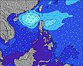 | 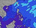 | 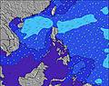 | 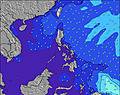 | 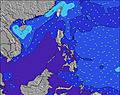 | 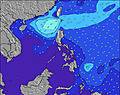 | 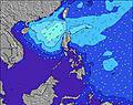 | ||||||||||||||
Wave Height (m) Direction Period (s) | NNW 4 | W 6 | WSW 5 | W 5 | W 6 | WSW 6 | NNW 5 | NNW 4 | WSW 8 | W 5 | WSW 9 | WNW 9 | W 8 | W 8 | WNW 9 | W 9 | W 9 | W 10 | W 10 | W 10 | NNE 15 |
Wave Graph | |||||||||||||||||||||
7 | 12 | 81 | 69 | 112 | 52 | 7 | 4 | 0 | 1 | 0 | 15 | 383 | 401 | 44 | 45 | 1251 | 1303 | 1346 | 1896 | 46 | |
Wind (km/h) | |||||||||||||||||||||
Wind State on-shore cross-onshore cross-shore cross-offshore off-shore glassy | off | off | off | cross-off | glassy | glassy | cross-off | cross-off | cross-off | cross-off | cross-off | off | cross-off | cross-off | cross | cross-off | cross | cross-off | cross-off | cross | cross |
High Tide | 11:09AM0.77m | 1:52AM0.51m | 11:44AM0.63m | 2:00AM0.62m | 12:12PM0.49m | 2:30AM0.75m | 3:13AM0.87m | 4:05AM0.98m | 5:03AM1.06m | ||||||||||||
Low Tide | 7:12PM0.32m | 5:16AM0.48m | 6:53PM0.37m | 8:53AM0.47m | 6:13PM0.38m | 4:00PM0.33m | 2:19PM0.20m | 3:00PM0.09m | 3:47PM0.01m | ||||||||||||
5:39 | — | — | 5:39 | — | — | 5:39 | — | — | 5:39 | — | — | 5:39 | — | — | 5:39 | — | — | 5:39 | — | — | |
— | 6:30 | — | — | 6:29 | — | — | 6:29 | — | — | 6:29 | — | — | 6:28 | — | — | 6:28 | — | — | 6:27 | — | |
mm | 1 | 2 | 7 | 1 | 11 | 20 | 5 | 4 | 19 | 7 | 8 | 6 | 8 | 9 | 46 | 18 | 46 | 134 | 21 | 15 | 40 |
Temp °C | 27 | 27 | 26 | 27 | 27 | 26 | 27 | 28 | 27 | 28 | 27 | 27 | 28 | 27 | 27 | 27 | 27 | 27 | 28 | 28 | 28 |
Feels °C | 32 | 30 | 28 | 31 | 32 | 31 | 32 | 30 | 29 | 29 | 31 | 31 | 32 | 30 | 31 | 28 | 28 | 27 | 29 | 29 | 29 |
Swell 1 Height (m) Direction Period (s) | NNW 4 | W 6 | NNW 6 | N 5 | — | N 5 | WSW 7 | WSW 7 | WSW 8 | WSW 8 | WSW 9 | WSW 9 | WNW 8 | W 8 | WNW 9 | W 9 | N 6 | W 10 | NNE 14 | NNE 15 | NNE 15 |
7 | 12 | 25 | 7 | — | 4 | 70 | 61 | 93 | 134 | 199 | 366 | 52 | 401 | 44 | 45 | 1 | 1303 | 20 | 22 | 46 | |
Swell 2 Height (m) Direction Period (s) | WSW 7 | NNW 4 | — | — | — | — | NNW 5 | NNW 4 | — | W 5 | — | WNW 9 | — | — | — | N 7 | — | N 15 | N 14 | N 14 | N 15 |
15 | 3 | — | — | — | — | 7 | 4 | — | 1 | — | 15 | — | — | — | 1 | — | 4 | 4 | 16 | 18 | |
Swell 3 Height (m) Direction Period (s) | — | W 7 | — | — | — | — | W 7 | — | — | — | — | — | — | — | — | — | — | — | — | — | — |
— | 1 | — | — | — | — | 4 | — | — | — | — | — | — | — | — | — | — | — | — | — | — | |
Wind waves Height (m) Direction Period (s) | — | — | WSW 5 | W 5 | W 6 | WSW 6 | — | SW 2 | — | — | — | — | W 8 | — | WSW 9 | W 10 | W 9 | WNW 7 | W 10 | W 10 | W 10 |
— | — | 81 | 69 | 112 | 52 | — | 1 | — | — | — | — | 383 | — | 918 | 1175 | 1251 | 115 | 1346 | 1896 | 1994 | |
Nearest Offshore or Glassy | |||||||||||||||||||||
Distance (km) | 158 | 158 | 0 | 1 | 0 | 1 | 158 | 140 | 81 | 158 | 158 | 158 | 0 | 158 | 158 | 166 | 166 | 166 | 400 | 400 | 400 |
Best forecast wave conditions in West Luzon | |||||||||||||||||||||
Best forecast wave conditions in Philippines | |||||||||||||||||||||
Header Global | |||||||||||||||||||||
- Map Icons:
 Break
Break Live Wave Height (m)
 Live Wind Speed (km/h)
 Surf Rating (10 Max)
 Ocean Swells (m)
- Wind Speed (km/h)
Latest Updates


FREE! Surf-Forecast.com widget for your website
The surf report / weather widget below is available to embed on third party websites free of charge and provides a summary of our San Juan surf forecast. Simply grab the html code snippet that we provide and paste it into your own site. You can choose your preferred language and metric/imperial units for the surf forecast feed to suit users of your site. Click here to get the code.
Information about the San Juan Surf forecast
The above surf forecast table for San Juan provides essential information for determining whether the surfing conditions will be good over the next 16 days. A general guide to surfing at San Juan can be found by selecting the local surf guide option on the grey menu. Our San Juan surf forecast is unique since it includes wave energy (power) that defines the real feel of the surf rather than just the height or the period. If you surf the same spot (San Juan) regularly then make a mental note of the wave energy from the surf forecast table each time you go. Very soon you may start to choose your surf days based on the wave energy alone combined with our forecast of favourable offshore wind conditions. Our star ratings will help here and of course you will also find the usual wave height and period predictions on our surf forecasts as well as a full break down of the swell components under our advanced users option (to reveal that, click the little Einstein character under the tide times).
Further information to help with frequently asked questions about our surf forecast for San Juan may be found under the help tab on the top menu and also by moving your mouse over the question marks on the surf forecast table itself. Please always bear in mind that the forecast is for near-shore open water and local factors at each surf break influence the actual breaking wave height, such as the beach / reef profile, water depths offshore and shelter.
 Nearest