

Surf Forecasts:

Playa Mojon surf forecast from 30 Jul 2026:
- Most powerful swell: Thursday 30 Jul, 7AM (local time) - 1ft (0.3m), 15s period, S swell with 40 kJ wave energy.
Best Forecast Surf Conditions for Playa Mojon this week:
The most powerful waves expected at Playa Mojon in the next 16 days are 0.3m 15s and forecast to arrive on Thursday (Jul 30) at 7AM. Winds are predicted to be glassy at the time the swell arrives. The largest open ocean swell (not directed at the beach) is 0.4m 3s period and expected on Thursday (Jul 30) at 10PM.
| Wave Type | Time (EST) & Date | Wave Height & Period |
|---|---|---|
| Next good surf (1 star+) | - | - |
| Best Surf | - | - |
| Most Powerful | 7AM (Thu 30th Jul) | 1ft (0.3m) 15s |
Table - best surf conditions forecast for Playa Mojon over the next 16 days.
The Lowdown
Alright, let’s get into it. This is Rusty, lookin’ at the surf for Playa Mojon.
Alright, let’s be straight with you – the next week and a half is a bit of a struggle for Playa Mojon. We’re looking at a long stretch of tiny, weak swell that’s just not doing much. The first real pulse of energy that’s even worth paddling out for doesn’t show up until Saturday, August 8th. So, from now until then, you’re looking at a dry spell of about 8 days with nothing really on offer.
The early part of the run is dominated by a very small south swell, only 0.7ft to 1ft, with periods that are all over the place. The combined energy is weak, bouncing between 15 and 45 (42 to 25), which is just not enough to get excited about. The wind is light and mostly offshore or glassy, which is a shame because the waves just aren’t there to make use of it.
The One Standout
The best we’ve got comes on Saturday, August 8th. The swell starts to lift a little, with a south swell at 1ft to 2ft. The period is a solid 16 seconds, so that’s a proper groundswell, and it’s pushing the combined energy into the moderate range (98 to 125). The wind is light and offshore or cross-offshore through the morning and afternoon, so the conditions will be clean. The water temp is about average for the time of year, so no surprises there. For a reef break that’s fairly consistent, this is the window to watch. The morning is the pick with clean offshore wind and glassy conditions. Crowds are likely here, so get there early.
Sunday, August 9th holds a little bit of that energy, with 1ft swell and a 14-second period, but the wind is a bit more variable. It’s still surfable, but Saturday is the clear winner.
After that, things drop off again. The swell fades back to 0.7ft to 1ft for the rest of the run, with only a few pockets of waist-high slop. The very long period swell (18-21 seconds) on the 10th and 11th is a tease – it’s got energy, but the height is so small it’s barely breaking.
So, the takeaway: wait for Saturday, August 8th. That’s your day. The rest is a whole lot of waiting.
Rusty.
Short Range ForecastHeavy rain (total 66mm), heaviest during Sat afternoon. Warm (max 31°C on Thu morning, min 25°C on Wed night). Wind will be generally light. | Days 4-6 Weather SummaryHeavy rain (total 20mm), heaviest during Sat night. Warm (max 30°C on Mon morning, min 24°C on Sat night). Wind will be generally light. | ||||||||||||||||||||
Thursday 30 | Friday 31 | Saturday 1 | Sunday 2 | Monday 3 | Tuesday 4 | Wednesday 5 | |||||||||||||||
AM | PM | Night | AM | PM | Night | AM | PM | Night | AM | PM | Night | AM | PM | Night | AM | PM | Night | AM | PM | Night | |
Swell Height Map |  |  |  | 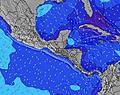 | 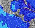 | 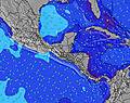 | 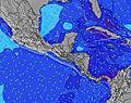 | ||||||||||||||
Wave Height (m) Direction Period (s) | S 15 | S 15 | S 14 | S 14 | S 14 | S 13 | S 13 | S 13 | S 13 | S 12 | S 12 | S 12 | S 12 | S 12 | S 7 | S 10 | S 9 | S 8 | SSW 13 | S 8 | S 8 |
Wave Graph | |||||||||||||||||||||
39 | 38 | 37 | 35 | 32 | 31 | 13 | 13 | 13 | 11 | 11 | 11 | 11 | 12 | 8 | 17 | 14 | 5 | 16 | 12 | 10 | |
Wind (km/h) | |||||||||||||||||||||
Wind State on-shore cross-onshore cross-shore cross-offshore off-shore glassy | glassy | cross-off | cross-off | off | cross-off | off | glassy | on | off | off | cross-off | off | glassy | cross-off | off | off | cross-off | off | cross | glassy | cross-off |
High Tide | 4:31AM4.32m | 4:38PM4.41m | 5:07AM4.48m | 5:15PM4.48m | 5:40AM4.59m | 5:50PM4.50m | 6:14AM4.65m | 6:26PM4.47m | 6:48AM4.66m | 7:04PM4.39m | 7:25AM4.62m | 7:46PM4.26m | 8:07AM4.52m | 8:33PM4.11m | |||||||
Low Tide | 10:33AM0.91m | 10:51PM0.54m | 11:10AM0.79m | 11:26PM0.49m | 11:46AM0.71m | 00:00AM0.49m | 12:22PM0.67m | 00:34AM0.55m | 12:59PM0.68m | 1:10AM0.65m | 1:39PM0.73m | 1:50AM0.79m | 2:23PM0.82m | 2:35AM0.96m | |||||||
6:07 | — | — | 6:07 | — | — | 6:07 | — | — | 6:09 | — | — | 6:09 | — | — | 6:09 | — | — | 6:09 | — | — | |
— | 6:39 | — | — | 6:38 | — | — | 6:38 | — | — | 6:38 | — | — | 6:38 | — | — | 6:37 | — | — | 6:37 | — | |
mm | 2 | 5 | — | 3 | 6 | 2 | 12 | 36 | 6 | — | 1 | — | 1 | 4 | 2 | 3 | 3 | — | 8 | 4 | — |
Temp °C | 31 | 30 | 26 | 30 | 29 | 26 | 30 | 26 | 25 | 29 | 28 | 26 | 30 | 29 | 26 | 30 | 29 | 26 | 27 | 27 | 26 |
Feels °C | 36 | 34 | 29 | 34 | 33 | 30 | 35 | 30 | 29 | 34 | 33 | 30 | 34 | 33 | 30 | 35 | 32 | 30 | 32 | 33 | 31 |
Swell 1 Height (m) Direction Period (s) | S 15 | S 15 | S 14 | S 14 | S 14 | S 13 | S 13 | S 13 | SE 4 | S 6 | S 6 | S 6 | S 6 | S 6 | S 7 | S 10 | S 9 | S 8 | S 8 | S 8 | S 8 |
39 | 38 | 37 | 35 | 32 | 31 | 13 | 13 | 2 | 3 | 7 | 6 | 7 | 7 | 8 | 17 | 14 | 5 | 12 | 12 | 10 | |
Swell 2 Height (m) Direction Period (s) | S 6 | S 6 | S 7 | SW 6 | S 6 | S 6 | S 6 | S 6 | S 13 | S 12 | S 12 | S 12 | S 12 | S 12 | S 13 | S 13 | S 15 | S 9 | S 13 | S 12 | S 14 |
1 | 1 | 1 | 2 | 1 | 1 | 3 | 3 | 13 | 11 | 11 | 11 | 11 | 12 | 3 | 3 | 4 | 2 | 3 | 3 | 4 | |
Swell 3 Height (m) Direction Period (s) | S 10 | S 9 | S 8 | S 8 | SW 6 | S 8 | — | S 21 | S 6 | S 19 | S 19 | S 15 | S 18 | S 17 | S 16 | S 16 | — | S 12 | SSW 13 | — | — |
2 | 2 | 1 | 1 | 1 | 1 | — | 8 | 2 | 7 | 7 | 4 | 6 | 6 | 5 | 5 | — | 3 | 16 | — | — | |
Wind waves Height (m) Direction Period (s) | — | — | NW 3 | NW 3 | — | — | — | SE 3 | — | — | — | NW 3 | — | — | — | NNW 3 | — | — | — | — | — |
— | — | 2 | 2 | — | — | — | 1 | — | — | — | 1 | — | — | — | 1 | — | — | — | — | — | |
Nearest Offshore or Glassy | |||||||||||||||||||||
Distance (km) | 1 | 1 | 62 | 62 | 304 | 66 | 184 | 66 | 66 | 62 | 66 | 66 | 62 | 71 | 66 | 68 | 71 | 66 | 62 | 62 | 62 |
Best forecast wave conditions in Gulf of Panama | |||||||||||||||||||||
Best forecast wave conditions in Panama | |||||||||||||||||||||
Header Global | |||||||||||||||||||||
- Map Icons:
 Break
Break Live Wave Height (m)
 Live Wind Speed (km/h)
 Surf Rating (10 Max)
 Ocean Swells (m)
- Wind Speed (km/h)
Latest Updates


FREE! Surf-Forecast.com widget for your website
The surf report / weather widget below is available to embed on third party websites free of charge and provides a summary of our Playa Mojon surf forecast. Simply grab the html code snippet that we provide and paste it into your own site. You can choose your preferred language and metric/imperial units for the surf forecast feed to suit users of your site. Click here to get the code.
Information about the Playa Mojon Surf forecast
The above surf forecast table for Playa Mojon provides essential information for determining whether the surfing conditions will be good over the next 16 days. A general guide to surfing at Playa Mojon can be found by selecting the local surf guide option on the grey menu. Our Playa Mojon surf forecast is unique since it includes wave energy (power) that defines the real feel of the surf rather than just the height or the period. If you surf the same spot (Playa Mojon) regularly then make a mental note of the wave energy from the surf forecast table each time you go. Very soon you may start to choose your surf days based on the wave energy alone combined with our forecast of favourable offshore wind conditions. Our star ratings will help here and of course you will also find the usual wave height and period predictions on our surf forecasts as well as a full break down of the swell components under our advanced users option (to reveal that, click the little Einstein character under the tide times).
Further information to help with frequently asked questions about our surf forecast for Playa Mojon may be found under the help tab on the top menu and also by moving your mouse over the question marks on the surf forecast table itself. Please always bear in mind that the forecast is for near-shore open water and local factors at each surf break influence the actual breaking wave height, such as the beach / reef profile, water depths offshore and shelter.
Playa Mojon is 3 km (2 miles) from the city of Panama. If you plan a holiday in Gulf of Panama, look for hotels and other accommodation in Panama. Panama has rooms for a wide range of budgets as well as car hire and transport links.
 Nearest