

Surf Forecasts:

How big are the waves at Maitencillo today (20 Jun):
- Morning surf: Morning surf (20 Jun, local time) - 4.5ft (1.3m), 12s period with SW swell.
- Afternoon surf: Afternoon surf (20 Jun, local time) - 4.5ft (1.3m), 19s period with SW swell.
- Evening surf: Evening surf (20 Jun, local time) - 10ft (3.0m), 18s period with SW swell.
The current surf forecast for Maitencillo at 3AM is: 1.5m 12s primary swell from a Southwest direction and 0.3m 12s secondary swell from a West-southwest direction, 0.9m 4s secondary swell from a South-southwest direction (forecast issued at 07:00pm June 19). The wind direction is predicted to be cross-offshore and the swell rating is 3.
| Time (-04) & Date | Wave Height | Wave Period |
|---|---|---|
| Morning (20 Jun) | 4.5ft (1.3m) | 12s |
| Afternoon (20 Jun) | 4.5ft (1.3m) | 19s |
| Evening (20 Jun) | 10ft (3.0m) | 18s |
Table - waves today at Maitencillo. (Swell directed towards the surf break)
Updates in hr min s Forecast update imminent
Short Range ForecastMostly dry. Very mild (max 15°C on Fri night, min 10°C on Sun morning). Wind will be generally light. | ||||||||||||||||||||||||
Fri 19 | Saturday 20 | Sunday 21 | Mon 22 | |||||||||||||||||||||
5 PM | 8 PM | 11 PM | 2 AM | 5 AM | 8 AM | 11 AM | 2 PM | 5 PM | 8 PM | 11 PM | 2 AM | 5 AM | 8 AM | 11 AM | 2 PM | 5 PM | 8 PM | 11 PM | 2 AM | 5 AM | 8 AM | 11 AM | 2 PM | |
Swell Height Map | 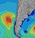 |  |  |  |  | 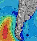 |  |  | 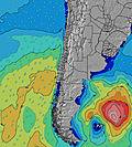 | |||||||||||||||
Wave Height (m) Direction Period (s) | SW 13 | SW 13 | SW 13 | SW 12 | SW 12 | SW 12 | SW 12 | SW 20 | SW 19 | SW 19 | SW 18 | SW 18 | SW 17 | SW 17 | SW 16 | SW 16 | SW 16 | SW 15 | SW 15 | SW 14 | SW 14 | SW 14 | SW 13 | SW 13 |
Wave Graph | ||||||||||||||||||||||||
991 | 1021 | 851 | 700 | 603 | 486 | 389 | 731 | 2216 | 4505 | 6365 | 10478 | 10945 | 9542 | 8453 | 7147 | 6461 | 5082 | 4823 | 4250 | 3454 | 3159 | 2782 | 2757 | |
Wind (km/h) | ||||||||||||||||||||||||
Wind State on-shore cross-onshore cross-shore cross-offshore off-shore glassy | cross-on | cross | glassy | cross-off | cross | cross | cross | cross-on | cross-on | cross | cross-off | cross-off | cross | cross | cross | cross-on | cross-on | cross | cross | cross | cross-off | cross-off | cross | cross-on |
High Tide | 2:30AM0.94m | 2:30PM1.33m | 3:31AM0.96m | 3:25PM1.18m | 4:34AM1.01m | |||||||||||||||||||
Low Tide | 8:30PM0.06m | 8:01AM0.29m | 9:21PM0.12m | 9:11AM0.37m | 10:11PM0.18m | 10:28AM0.42m | ||||||||||||||||||
— | — | — | — | 7:47 | — | — | — | — | — | — | — | 7:47 | — | — | — | — | — | — | — | 7:48 | — | — | — | |
5:46 | — | — | — | — | — | — | — | 5:46 | — | — | — | — | — | — | — | 5:46 | — | — | — | — | — | — | 5:46 | |
mm | — | — | — | — | — | — | — | — | — | — | — | — | — | — | — | — | — | — | — | — | — | — | — | — |
Temp °C | 14 | 15 | 14 | 13 | 13 | 13 | 14 | 15 | 14 | 12 | 11 | 11 | 11 | 10 | 12 | 14 | 14 | 12 | 11 | 11 | 11 | 11 | 12 | 14 |
Feels °C | 11 | 14 | 13 | 11 | 11 | 11 | 12 | 10 | 10 | 9 | 9 | 9 | 7 | 6 | 8 | 8 | 8 | 8 | 7 | 7 | 7 | 7 | 8 | 8 |
Swell 1 Height (m) Direction Period (s) | SW 13 | SW 13 | SW 13 | SW 12 | SW 12 | SW 12 | SW 12 | SW 20 | SW 19 | SW 19 | SW 18 | SW 18 | SW 17 | SW 17 | SW 16 | SW 16 | SW 16 | SW 15 | SW 15 | SW 14 | SW 14 | SW 14 | SW 13 | NW 13 |
991 | 1021 | 851 | 700 | 603 | 486 | 389 | 731 | 2216 | 4505 | 6365 | 10478 | 10945 | 9542 | 8453 | 7147 | 6461 | 5082 | 4823 | 4250 | 3454 | 3159 | 2782 | 7 | |
Swell 2 Height (m) Direction Period (s) | SW 13 | WNW 7 | WSW 12 | WSW 12 | WSW 12 | WSW 12 | SW 21 | WNW 15 | WNW 14 | NW 14 | SW 18 | — | — | — | — | — | — | — | — | — | — | — | NW 13 | — |
45 | 9 | 83 | 57 | 29 | 48 | 274 | 21 | 21 | 8 | 3022 | — | — | — | — | — | — | — | — | — | — | — | 7 | — | |
Swell 3 Height (m) Direction Period (s) | WNW 7 | NW 10 | WNW 7 | WNW 7 | WNW 15 | SW 21 | WSW 11 | NW 10 | NW 10 | — | — | — | — | — | — | — | — | — | — | — | — | — | W 13 | — |
9 | 16 | 4 | 4 | 21 | 117 | 74 | 4 | 4 | — | — | — | — | — | — | — | — | — | — | — | — | — | 3 | — | |
Wind waves Height (m) Direction Period (s) | SSW 3 | SSW 4 | SSW 4 | SSW 4 | SSW 4 | SSW 5 | SSW 5 | SW 11 | SSW 11 | SW 7 | SW 7 | — | SSW 7 | — | — | — | — | SSW 5 | — | — | — | — | — | SW 13 |
5 | 16 | 18 | 25 | 29 | 27 | 40 | 726 | 973 | 400 | 440 | — | 211 | — | — | — | — | 67 | — | — | — | — | — | 2757 | |
Nearest Offshore or Glassy | ||||||||||||||||||||||||
Distance (km) | 80 | 25 | 0 | 0 | 16 | 25 | 25 | 510 | 310 | 25 | 5 | 25 | 25 | 25 | 105 | 510 | 510 | 310 | 25 | 25 | 5 | 5 | 25 | 436 |
Best forecast wave conditions in Santiago | ||||||||||||||||||||||||
Best forecast wave conditions in Chile | ||||||||||||||||||||||||
Header Global | ||||||||||||||||||||||||
- Map Icons:
 Break
Break Live Wave Height (m)
 Live Wind Speed (km/h)
 Surf Rating (10 Max)
 Ocean Swells (m)
- Wind Speed (km/h)


FREE! Surf-Forecast.com widget for your website
The surf report / weather widget below is available to embed on third party websites free of charge and provides a summary of our Maitencillo surf forecast. Simply grab the html code snippet that we provide and paste it into your own site. You can choose your preferred language and metric/imperial units for the surf forecast feed to suit users of your site. Click here to get the code.
 Nearest