

Surf Forecasts:

Maeda Point surf forecast from 15 Jul 2026:
- Most powerful swell: Sunday 19 Jul, 6AM (local time) - 3ft (0.9m), 8s period, W swell with 92 kJ wave energy.
Best Forecast Surf Conditions for Maeda Point this week:
The most powerful waves expected at Maeda Point in the next 16 days are 0.9m 8s and forecast to arrive on Sunday (Jul 19) at 6AM. Winds are predicted to be cross-shore at the time the swell arrives. The largest open ocean swell (not directed at the beach) is 1.3m 8s period and expected on Sunday (Jul 19) at 3AM.
| Wave Type | Time (JST) & Date | Wave Height & Period |
|---|---|---|
| Next good surf (1 star+) | - | - |
| Best Surf | - | - |
| Most Powerful | 6AM (Sun 19th Jul) | 3ft (0.9m) 8s |
Table - best surf conditions forecast for Maeda Point over the next 16 days.
The Lowdown
Alright folks, Rusty here. Let’s have a look at what’s happening with Maeda Point over the next couple of weeks. I gotta be straight with you – it’s a grim start. For the first week and a half, there’s just nothing doing. The swell is tiny, the winds are messy, and every session is marked as poor surf conditions. From the 16th of July right through to the morning of the 29th of July, you’re looking at a real flat spell with onshore or cross-shore breezes and barely a ripple worth paddling for.
Now, if you’ve got some patience, things finally start to look interesting right at the tail end of the forecast. On the morning of the 30th of July, we get a proper pulse of energy. The swell jumps up to 8 ft from the west, with a period of 12 seconds – that’s a solid groundswell. The combined energy reads 1830, which is strong and powerful. You can feel the difference. That said, the wind is light and cross-onshore from the north-northeast at only 3 mph, so it’s not totally clean but it’s workable. This is a reef break, and with that long period west swell, it should line up nicely. The catch? Maeda Point is a reef, so with 8 ft swell, this is expert territory. Beginners should sit this one out.
The afternoon of the 30th drops a little to 7 ft from the west, still a solid 12-second period, but the wind picks up to a moderate cross-onshore and it gets choppy. The energy is still strong at 1103, but the quality takes a hit.
Looking at the 31st of July, Friday morning, we’ve still got some west swell at 3 ft, but the wind is moderate and cross-onshore again, making it a bit of a messy option. The combined energy is 200, so it’s much weaker.
If I had to pick the standout, it’s the morning of the 30th of July. That’s the only window where the swell size, period, and light wind come together for a proper session. It’s a long way off, so keep an eye on it, but it’s the best we’ve got by a long shot.
Water temp is about average for the time of year, nothing weird going on there. Crowds can show up at Maeda Point sometimes, so don’t expect to have it all to yourself if the swell delivers.
Stay patient, and mark the 30th on your calendar.
– Rusty
Short Range ForecastMostly dry. Warm (max 29°C on Sat morning, min 27°C on Thu morning). Wind will be generally light. | Days 4-6 Weather SummaryMostly dry. Warm (max 29°C on Sun morning, min 26°C on Sun night). Wind will be generally light. | ||||||||||||||||||||
Thursday 16 | Friday 17 | Saturday 18 | Sunday 19 | Monday 20 | Tuesday 21 | Wednesday 22 | |||||||||||||||
AM | PM | Night | AM | PM | Night | AM | PM | Night | AM | PM | Night | AM | PM | Night | AM | PM | Night | AM | PM | Night | |
Swell Height Map |  |  |  | 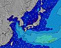 | 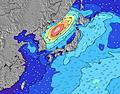 | 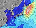 | 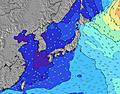 | ||||||||||||||
Wave Height (m) Direction Period (s) | WSW 4 | WSW 5 | WSW 5 | WSW 5 | E 10 | W 6 | W 8 | W 7 | W 9 | W 7 | W 7 | E 9 | W 7 | E 10 | ENE 10 | ENE 9 | ENE 9 | W 8 | W 7 | W 8 | ENE 11 |
Wave Graph | |||||||||||||||||||||
16 | 17 | 20 | 51 | 7 | 38 | 44 | 63 | 76 | 85 | 61 | 7 | 9 | 7 | 9 | 8 | 8 | 10 | 8 | 21 | 23 | |
Wind (km/h) | |||||||||||||||||||||
Wind State on-shore cross-onshore cross-shore cross-offshore off-shore glassy | cross | cross | cross | cross | cross | cross | cross | cross | cross | cross | cross | cross | cross | cross | glassy | glassy | on | glassy | cross-on | cross-on | cross |
High Tide | 8:48PM2.09m | 8:12AM2.17m | 9:24PM2.06m | 8:58AM2.06m | 9:57PM2.01m | 9:46AM1.91m | 10:29PM1.97m | 10:37AM1.75m | 11:00PM1.91m | 11:37AM1.59m | 11:34PM1.85m | 12:58PM1.48m | 00:16AM1.79m | ||||||||
Low Tide | 2:13PM0.05m | 2:26AM0.90m | 2:53PM0.18m | 3:11AM0.85m | 3:30PM0.35m | 3:56AM0.82m | 4:05PM0.55m | 4:44AM0.81m | 4:39PM0.76m | 5:35AM0.81m | 5:14PM0.96m | 6:36AM0.81m | 5:59PM1.14m | ||||||||
5:45 | — | — | 5:46 | — | — | 5:46 | — | — | 5:47 | — | — | 5:47 | — | — | 5:48 | — | — | 5:48 | — | — | |
— | 7:22 | — | — | 7:22 | — | — | 7:22 | — | — | 7:22 | — | — | 7:22 | — | — | 7:22 | — | — | 7:21 | — | |
mm | — | — | — | — | — | — | — | — | — | — | — | — | — | — | — | — | — | — | — | — | — |
Temp °C | 28 | 28 | 27 | 28 | 28 | 28 | 29 | 29 | 28 | 29 | 28 | 27 | 28 | 28 | 27 | 28 | 28 | 27 | 28 | 28 | 27 |
Feels °C | 32 | 32 | 31 | 31 | 31 | 30 | 31 | 31 | 30 | 30 | 30 | 30 | 31 | 30 | 32 | 31 | 31 | 31 | 30 | 30 | 29 |
Swell 1 Height (m) Direction Period (s) | SW 10 | SW 9 | SW 9 | W 8 | E 10 | W 6 | W 8 | W 7 | W 9 | W 7 | W 7 | WSW 8 | WSW 8 | WSW 8 | WSW 8 | SW 8 | SW 8 | WSW 8 | SW 8 | SW 8 | SW 8 |
58 | 42 | 39 | 10 | 7 | 38 | 44 | 63 | 76 | 85 | 61 | 117 | 112 | 88 | 74 | 60 | 64 | 54 | 30 | 31 | 21 | |
Swell 2 Height (m) Direction Period (s) | E 9 | E 10 | ESE 10 | E 10 | SE 9 | ESE 9 | SE 9 | SE 8 | E 10 | E 10 | E 9 | E 9 | W 7 | E 10 | ENE 10 | ENE 9 | ENE 9 | W 8 | W 7 | W 8 | W 7 |
7 | 7 | 19 | 8 | 3 | 8 | 3 | 3 | 7 | 7 | 7 | 7 | 9 | 7 | 9 | 8 | 8 | 10 | 8 | 21 | 15 | |
Swell 3 Height (m) Direction Period (s) | S 7 | S 7 | S 9 | SE 9 | S 7 | E 10 | E 10 | E 10 | SE 8 | SE 9 | SE 9 | SE 9 | E 10 | SE 9 | SE 8 | S 7 | S 7 | ENE 9 | ENE 9 | ENE 9 | ENE 11 |
4 | 4 | 2 | 3 | 1 | 8 | 8 | 7 | 3 | 3 | 3 | 3 | 7 | 3 | 3 | 1 | 1 | 8 | 8 | 8 | 23 | |
Wind waves Height (m) Direction Period (s) | WSW 4 | WSW 5 | WSW 5 | WSW 5 | WSW 6 | SW 8 | SW 8 | SW 7 | SW 8 | SW 8 | SW 8 | — | SW 8 | — | — | — | — | — | — | — | — |
16 | 17 | 20 | 51 | 72 | 66 | 91 | 51 | 90 | 88 | 79 | — | 63 | — | — | — | — | — | — | — | — | |
Nearest Offshore or Glassy | |||||||||||||||||||||
Distance (km) | 615 | 679 | 657 | 648 | 657 | 68 | 648 | 68 | 54 | 648 | 690 | 35 | 68 | 854 | 11 | 11 | 35 | 11 | 35 | 35 | 35 |
Best forecast wave conditions in Okinawa | |||||||||||||||||||||
Best forecast wave conditions in Japan | |||||||||||||||||||||
Header Global | |||||||||||||||||||||
- Map Icons:
 Break
Break Live Wave Height (m)
 Live Wind Speed (km/h)
 Surf Rating (10 Max)
 Ocean Swells (m)
- Wind Speed (km/h)


FREE! Surf-Forecast.com widget for your website
The surf report / weather widget below is available to embed on third party websites free of charge and provides a summary of our Maeda Point surf forecast. Simply grab the html code snippet that we provide and paste it into your own site. You can choose your preferred language and metric/imperial units for the surf forecast feed to suit users of your site. Click here to get the code.
Information about the Maeda Point Surf forecast
The above surf forecast table for Maeda Point provides essential information for determining whether the surfing conditions will be good over the next 16 days. A general guide to surfing at Maeda Point can be found by selecting the local surf guide option on the grey menu. Our Maeda Point surf forecast is unique since it includes wave energy (power) that defines the real feel of the surf rather than just the height or the period. If you surf the same spot (Maeda Point) regularly then make a mental note of the wave energy from the surf forecast table each time you go. Very soon you may start to choose your surf days based on the wave energy alone combined with our forecast of favourable offshore wind conditions. Our star ratings will help here and of course you will also find the usual wave height and period predictions on our surf forecasts as well as a full break down of the swell components under our advanced users option (to reveal that, click the little Einstein character under the tide times).
Further information to help with frequently asked questions about our surf forecast for Maeda Point may be found under the help tab on the top menu and also by moving your mouse over the question marks on the surf forecast table itself. Please always bear in mind that the forecast is for near-shore open water and local factors at each surf break influence the actual breaking wave height, such as the beach / reef profile, water depths offshore and shelter.
Maeda Point is 5 km (3 miles) from the city of Ishikawa. If you plan a holiday in Okinawa, look for hotels and other accommodation in Ishikawa. Ishikawa has rooms for a wide range of budgets as well as car hire and transport links.
 Nearest