

Surf Forecasts:

El Muelle surf forecast from 3 Aug 2026:
- Best quality surf: Sunday 9 Aug, 9AM (local time) - 10ft (3.0m), 8s period, SW swell with cross-offshore winds.
- Most powerful swell: Sunday 9 Aug, 9PM (local time) - 11ft (3.5m), 10s period, SSW swell with 2,212 kJ wave energy.
- Next surfable swell (1★+): Monday 3 Aug, 12AM (local time) - 4.5ft (1.4m), 11s period with S swell.
Best Forecast Surf Conditions for El Muelle this week:
The surf forecast for El Muelle over the next 16 days: The first swell (rated 1 star or higher) is forecast to arrive on Monday (Aug 03) at 12AM. The primary swell is predicted to be 1.4m and 11s period with a secondary swell of 0.9m and 5s. The wind is predicted to be cross-offshore as the swell arrives.
The most powerful waves expected at El Muelle in the next 16 days are 3.5m 10s and forecast to arrive on Sunday (Aug 09) at 9PM. Winds are predicted to be cross-offshore at the time the swell arrives. The largest open ocean swell (not directed at the beach) is 1.6m 6s period and expected on Saturday (Aug 08) at 12PM.
| Wave Type | Time (-03) & Date | Wave Height & Period |
|---|---|---|
| Next good surf (1 star+) | 12AM (Mon 3rd Aug) | 4.5ft (1.4m) 11s |
| Best Surf | 9AM (Sun 9th Aug) | 10ft (3.0m) 8s |
| Most Powerful | 9PM (Sun 9th Aug) | 11ft (3.5m) 10s |
Table - best surf conditions forecast for El Muelle over the next 16 days.
The Lowdown
Alright folks, Rusty here. Let’s get into it.
We’ve got a 16-day window of surf ahead, but it’s a real slow start. The first proper recommendation isn’t until the morning of Monday, the 3rd of August, so plan for a quiet couple of days.
The standout for the whole period is El Muelle on Monday morning, the 3rd of August. We’re looking at a clean 5-foot swell from the SSE with a period of 10 seconds, and a light NNW wind that’s blowing cross-offshore. The combined energy is moderate at 547. That’s a solid, surfable wave with good shape. The water temp is an unusual 51°, which is a massive 4° warmer than normal for this time of year, so you won’t need a thick suit.
Things get a bit messy after that. Tuesday morning, the 4th sees a smaller 4-foot SE swell (10 seconds) with a clean offshore WNW wind, but the energy drops to 326. It’s a decent option, but not a standout. The afternoon glass-off with 3-foot SE swell and zero wind is a nice window for a quiet session, but again, not a barnstormer.
From Wednesday the 5th onwards, it’s mostly ordinary. The swell fades into the 2-foot range with poor wind conditions, and by Thursday the 6th, the energy is weak (43). The weekend of the 7th and 8th gets blown out with strong SW winds and messy 7-foot cross-shore slop. That’s a write-off.
The second week has a couple of moments, but they come with serious caveats. On Sunday the 9th, the swell jumps to a massive 10-foot from the SW, with a combined energy of 1076. That’s a strong swell, but it’s too big for this break. This is a beach/pier setup, and with that size and a fresh cross-offshore breeze, it’s more interesting for the kite surfers than paddle surfers. Monday the 10th is even bigger – 16-foot from the SSW with a period of 12 seconds and an energy reading of 6901. That’s very strong, and again, too big for the break. Only for experts, and even then, it’s a serious call.
The promising long-range call is Sunday the 16th in the afternoon. A 4-foot ENE swell with an 8-second period, combined with a clean, moderate offshore NNW wind at 12 mph. The energy is 213, so it’s moderate, but that offshore wind is a major positive. It’s a nice prospect, but it’s deep in the second week, so treat it as promising but not locked in. Crowds are a possibility here sometimes, so keep that in mind.
In short, Monday the 3rd morning is your best bet. The rest is a mixed bag of junk, too-big swell, or a distant hope for the 16th.
Rusty.
Short Range ForecastMostly dry. Very mild (max 16°C on Tue afternoon, min 11°C on Sun afternoon). Winds decreasing (fresh winds from the NE on Sun afternoon, calm by Mon night). | Days 5-7 Weather SummaryHeavy rain (total 25mm), heaviest during Thu night. Very mild (max 16°C on Thu afternoon, min 6°C on Fri night). Winds increasing (light winds from the SSW on Wed afternoon, strong winds from the SW by Thu night). | |||||||||||||||||||
Sun 2 | Monday 3 | Tuesday 4 | Wednesday 5 | Thursday 6 | Friday 7 | Saturday 8 | ||||||||||||||
PM | Night | AM | PM | Night | AM | PM | Night | AM | PM | Night | AM | PM | Night | AM | PM | Night | AM | PM | Night | |
Swell Height Map |  | 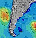 | 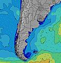 | 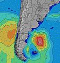 | 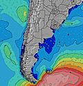 | 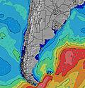 | 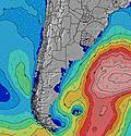 | |||||||||||||
Wave Height (m) Direction Period (s) | ENE 9 | S 11 | SSE 10 | SE 11 | SE 11 | SE 10 | SE 10 | SE 10 | SE 9 | SE 9 | SE 9 | SE 8 | ENE 7 | ENE 6 | SW 6 | SSW 7 | SSW 7 | S 8 | WSW 7 | SSW 6 |
Wave Graph | ||||||||||||||||||||
104 | 449 | 502 | 467 | 415 | 296 | 188 | 154 | 99 | 67 | 39 | 19 | 19 | 56 | 388 | 518 | 327 | 134 | 363 | 315 | |
Wind (km/h) | ||||||||||||||||||||
Wind State on-shore cross-onshore cross-shore cross-offshore off-shore glassy | cross | cross-off | cross-off | cross | glassy | off | glassy | cross-off | off | cross | cross-off | cross-off | cross-off | cross | cross | cross | off | cross-off | cross-off | cross-on |
High Tide | 9:52PM1.29m | 10:25AM1.02m | 10:35PM1.26m | 11:01AM1.07m | 11:21PM1.20m | 11:40AM1.13m | 00:12AM1.14m | 12:24PM1.19m | 1:09AM1.07m | 1:13PM1.24m | 2:12AM1.00m | 2:10PM1.29m | ||||||||
Low Tide | 4:16PM0.43m | 5:15AM0.25m | 5:01PM0.39m | 5:48AM0.30m | 5:46PM0.35m | 6:20AM0.37m | 6:35PM0.30m | 6:50AM0.43m | 7:28PM0.26m | 7:21AM0.49m | 8:28PM0.22m | 7:57AM0.53m | 9:36PM0.18m | |||||||
— | — | 7:50 | — | — | 7:50 | — | — | 7:48 | — | — | 7:47 | — | — | 7:46 | — | — | 7:45 | — | — | |
6:02 | — | — | 6:04 | — | — | 6:05 | — | — | 6:06 | — | — | 6:07 | — | — | 6:07 | — | — | 6:07 | — | |
mm | — | — | — | — | — | — | — | — | — | — | — | — | — | 25 | — | — | — | — | — | 2 |
Temp °C | 12 | 12 | 13 | 15 | 14 | 14 | 16 | 14 | 14 | 15 | 13 | 14 | 16 | 15 | 10 | 10 | 8 | 10 | 11 | 8 |
Feels °C | 9 | 11 | 12 | 14 | 14 | 12 | 14 | 11 | 13 | 14 | 11 | 10 | 13 | 12 | 1 | 1 | 3 | 5 | 5 | 0 |
Swell 1 Height (m) Direction Period (s) | SSW 7 | S 11 | SSE 10 | SE 11 | SE 11 | SE 10 | SE 10 | SE 10 | SE 9 | SE 9 | SE 9 | ENE 7 | ENE 7 | ENE 6 | ENE 7 | ENE 7 | SSW 7 | S 8 | SSE 8 | NE 8 |
57 | 449 | 502 | 467 | 415 | 296 | 188 | 154 | 99 | 67 | 39 | 19 | 19 | 56 | 26 | 16 | 327 | 134 | 94 | 3 | |
Swell 2 Height (m) Direction Period (s) | ENE 9 | ENE 5 | ENE 9 | ENE 9 | ENE 8 | ENE 8 | ENE 8 | NE 8 | ENE 8 | ENE 7 | ENE 7 | SE 8 | ESE 8 | SSW 6 | — | — | ENE 7 | ENE 7 | ENE 7 | ENE 8 |
100 | 51 | 45 | 50 | 40 | 28 | 26 | 16 | 23 | 31 | 30 | 18 | 6 | 3 | — | — | 9 | 5 | 5 | 6 | |
Swell 3 Height (m) Direction Period (s) | S 12 | ENE 9 | NE 5 | S 10 | S 10 | WSW 4 | S 8 | SW 6 | S 11 | SW 7 | SW 7 | SW 6 | SSW 6 | NNW 3 | — | — | — | — | — | — |
104 | 47 | 13 | 2 | 2 | 2 | 5 | 5 | 3 | 27 | 15 | 6 | 3 | 1 | — | — | — | — | — | — | |
Wind waves Height (m) Direction Period (s) | NE 3 | — | — | — | — | — | — | N 3 | W 3 | WSW 6 | — | NNE 3 | NNE 4 | W 3 | SW 6 | SSW 7 | WSW 7 | W 5 | WSW 7 | SSW 6 |
5 | — | — | — | — | — | — | 4 | 5 | 24 | — | 10 | 24 | 1 | 388 | 518 | 153 | 124 | 363 | 315 | |
Nearest Offshore or Glassy | ||||||||||||||||||||
Distance (km) | 34 | 0 | 0 | 11 | 0 | 0 | 0 | 34 | 0 | 11 | 3 | 462 | 482 | 454 | 1111 | 236 | 0 | 43 | 43 | 455 |
Best forecast wave conditions in Provincia de Buenos Aires | ||||||||||||||||||||
Best forecast wave conditions in Argentina | ||||||||||||||||||||
Header Global | ||||||||||||||||||||
- Map Icons:
 Break
Break Live Wave Height (m)
 Live Wind Speed (km/h)
 Surf Rating (10 Max)
 Ocean Swells (m)
- Wind Speed (km/h)
Latest Updates


FREE! Surf-Forecast.com widget for your website
The surf report / weather widget below is available to embed on third party websites free of charge and provides a summary of our El Muelle surf forecast. Simply grab the html code snippet that we provide and paste it into your own site. You can choose your preferred language and metric/imperial units for the surf forecast feed to suit users of your site. Click here to get the code.
Information about the El Muelle Surf forecast
The above surf forecast table for El Muelle provides essential information for determining whether the surfing conditions will be good over the next 16 days. A general guide to surfing at El Muelle can be found by selecting the local surf guide option on the grey menu. Our El Muelle surf forecast is unique since it includes wave energy (power) that defines the real feel of the surf rather than just the height or the period. If you surf the same spot (El Muelle) regularly then make a mental note of the wave energy from the surf forecast table each time you go. Very soon you may start to choose your surf days based on the wave energy alone combined with our forecast of favourable offshore wind conditions. Our star ratings will help here and of course you will also find the usual wave height and period predictions on our surf forecasts as well as a full break down of the swell components under our advanced users option (to reveal that, click the little Einstein character under the tide times).
Further information to help with frequently asked questions about our surf forecast for El Muelle may be found under the help tab on the top menu and also by moving your mouse over the question marks on the surf forecast table itself. Please always bear in mind that the forecast is for near-shore open water and local factors at each surf break influence the actual breaking wave height, such as the beach / reef profile, water depths offshore and shelter.
Are you planning a holiday in Provincia de Buenos Aires? If you are looking for accommodation near El Muelle, camping, hotels and holiday cottages in Provincia de Buenos Aires, consider staying in Mar del Plata which is 41 km (25 miles) away. Other places in and around Provincia de Buenos Aires where you can find information about places to rent, and car hire include Quequen which is 79 km (49 miles) away and Necochea, 84 km (52 miles) away.
 Nearest