

Surf Forecasts:

Conchitas surf forecast from 25 Jul 2026:
- Best quality surf: Sunday 26 Jul, 4AM (local time) - 2.5ft (0.7m), 20s period, SW swell with cross-offshore winds.
- Most powerful swell: Monday 27 Jul, 4PM (local time) - 5ft (1.5m), 16s period, WSW swell with 1,214 kJ wave energy.
- Next surfable swell (1★+): Sunday 26 Jul, 4AM (local time) - 2.5ft (0.7m), 20s period with SW swell.
Best Forecast Surf Conditions for Conchitas this week:
The surf forecast for Conchitas over the next 16 days: The first swell (rated 1 star or higher) is forecast to arrive on Sunday (Jul 26) at 4AM. The primary swell is predicted to be 0.7m and 20s period with a secondary swell of 0.8m and 16s. The wind is predicted to be cross-offshore as the swell arrives.
The most powerful waves expected at Conchitas in the next 16 days are 1.5m 16s and forecast to arrive on Monday (Jul 27) at 4PM. Winds are predicted to be cross-shore at the time the swell arrives. The largest open ocean swell (not directed at the beach) is 1.2m 11s period and expected on Sunday (Jul 26) at 1AM.
| Wave Type | Time (-05) & Date | Wave Height & Period |
|---|---|---|
| Next good surf (1 star+) | 4AM (Sun 26th Jul) | 2.5ft (0.7m) 20s |
| Best Surf | 4AM (Sun 26th Jul) | 2.5ft (0.7m) 20s |
| Most Powerful | 4PM (Mon 27th Jul) | 5ft (1.5m) 16s |
Table - best surf conditions forecast for Conchitas over the next 16 days.
The Lowdown
Alright, Rusty here. Let's talk about Conchitas.
It’s a consistent beach and point that’s exposed to the swell, and right now the water is sitting at 71° which is much warmer than normal for this time of year – a real surprise.
Honestly, it’s a tough stretch ahead. There’s really no standout session in the next 16 days. The waves are there, but they’re pretty much all tagged as marginal, and the wind is never fully offshore. We start on Saturday, July 25th with a 3ft swell from the SW at a very long 18 seconds, but the wind is a light cross-onshore, making it choppy. The combined energy is moderate to strong at 724, but that long period at a beach setup like Conchitas might make it a bit straight. Scores are low.
Things actually look best on Monday, July 27th. The swell bumps up to 4ft in the morning from the WSW with a long 18 second period, and the wind is just a light cross-shore. Combined energy hits strong at 1119. It’s still not a classic forecast, but the morning session on Monday is the cleanest option we have. By the afternoon the wind picks up to 12 mph and the chop gets worse.
The rest of the run is pretty much the same story: small to waist-high swell, mostly between 3ft and 5ft, with the wind never fully cleaning it up. The swell direction hangs in the SW to WSW with periods dropping from those super long 18-second waves down to 11-13 seconds. The energy drops off notably after the 30th of July, falling to 2-digit figures by the end of the first week on August 1st.
There’s one more spike to watch on Friday, August 7th. The afternoon shows a 5ft swell from the SW at 15 seconds, with combined energy shooting back up to 1023. But the wind is howling at 12 mph from the south, creating a rough cross-chop. It’s one to keep an eye on if the forecast changes and the wind backs off.
By the second week, August 9th, the swell goes almost flat at 0.3ft with a tiny 22 energy reading. It’s going to be a long wait.
The best advice? Monday morning, July 27th, is your best chance for the most surfable waves. Don’t expect perfection, but it’s the closest we’ll get.
Rusty.
Short Range ForecastMostly dry. Warm (max 21°C on Sat morning, min 18°C on Mon night). Wind will be generally light. | Days 4-6 Weather SummaryMostly dry. Warm (max 21°C on Tue afternoon, min 18°C on Tue night). Wind will be generally light. | ||||||||||||||||||||
Saturday 25 | Sunday 26 | Monday 27 | Tuesday 28 | Wednesday 29 | Thursday 30 | Friday 31 | |||||||||||||||
AM | PM | Night | AM | PM | Night | AM | PM | Night | AM | PM | Night | AM | PM | Night | AM | PM | Night | AM | PM | Night | |
Swell Height Map | 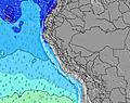 | 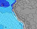 | 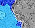 | 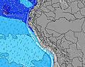 | 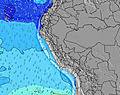 | 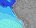 | 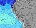 | ||||||||||||||
Wave Height (m) Direction Period (s) | SW 18 | SW 18 | SW 16 | SW 20 | SW 19 | SW 18 | WSW 18 | WSW 16 | WSW 16 | WSW 15 | SW 15 | SW 14 | SW 13 | SW 13 | SW 13 | SW 12 | SW 12 | SW 13 | SW 12 | SW 12 | SW 12 |
Wave Graph | |||||||||||||||||||||
522 | 444 | 376 | 455 | 436 | 614 | 1021 | 1214 | 1170 | 1028 | 869 | 846 | 792 | 690 | 659 | 486 | 442 | 411 | 278 | 236 | 161 | |
Wind (km/h) | |||||||||||||||||||||
Wind State on-shore cross-onshore cross-shore cross-offshore off-shore glassy | cross-on | cross-on | cross | cross-on | cross-on | cross | cross | cross | cross-off | cross | cross-on | cross | cross | cross-on | cross | cross-on | cross | cross | cross | cross | cross |
High Tide | 2:18PM0.54m | 4:19AM0.85m | 3:09PM0.55m | 4:53AM0.88m | 3:52PM0.56m | 5:26AM0.92m | 4:31PM0.58m | 5:56AM0.95m | 5:08PM0.60m | 6:25AM0.96m | 5:46PM0.62m | 6:52AM0.97m | 6:24PM0.63m | ||||||||
Low Tide | 10:15AM0.44m | 8:56PM0.19m | 10:51AM0.41m | 9:36PM0.15m | 11:23AM0.39m | 10:13PM0.12m | 11:53AM0.37m | 10:47PM0.11m | 12:23PM0.36m | 11:20PM0.11m | 12:52PM0.35m | 11:51PM0.13m | 1:20PM0.33m | 00:22AM0.17m | |||||||
6:28 | — | — | 6:28 | — | — | 6:28 | — | — | 6:28 | — | — | 6:28 | — | — | 6:28 | — | — | 6:28 | — | — | |
— | 6:04 | — | — | 6:04 | — | — | 6:04 | — | — | 6:04 | — | — | 6:05 | — | — | 6:05 | — | — | 6:05 | — | |
mm | — | — | — | — | — | — | — | — | — | — | — | — | — | — | — | — | — | — | — | — | — |
Temp °C | 21 | 21 | 20 | 21 | 21 | 19 | 20 | 20 | 19 | 20 | 21 | 19 | 21 | 21 | 19 | 21 | 21 | 19 | 21 | 20 | 19 |
Feels °C | 21 | 21 | 20 | 21 | 21 | 18 | 19 | 18 | 18 | 20 | 21 | 18 | 21 | 21 | 19 | 21 | 21 | 18 | 20 | 18 | 17 |
Swell 1 Height (m) Direction Period (s) | SSW 9 | SW 12 | SSW 11 | WSW 15 | SW 19 | SW 18 | WSW 18 | WSW 16 | WSW 16 | WSW 15 | SW 15 | SW 14 | SW 13 | SW 13 | SW 13 | SW 12 | SW 12 | SW 13 | SW 12 | SW 12 | SW 12 |
116 | 236 | 329 | 393 | 436 | 614 | 1021 | 1214 | 1170 | 1028 | 869 | 846 | 792 | 690 | 659 | 486 | 442 | 411 | 278 | 236 | 161 | |
Swell 2 Height (m) Direction Period (s) | SW 18 | SW 18 | SW 16 | SW 11 | WSW 14 | WSW 14 | SW 10 | SSW 9 | S 7 | WNW 13 | S 7 | S 7 | S 7 | S 7 | S 7 | S 7 | SSW 11 | W 12 | SW 17 | S 10 | SSW 10 |
522 | 444 | 376 | 162 | 264 | 210 | 58 | 15 | 55 | 17 | 73 | 96 | 96 | 76 | 60 | 32 | 98 | 3 | 11 | 51 | 32 | |
Swell 3 Height (m) Direction Period (s) | SW 13 | SSW 9 | SW 21 | SW 20 | SW 10 | SW 10 | WNW 14 | WNW 14 | WNW 14 | S 12 | SSW 11 | SSW 10 | WNW 13 | WNW 13 | W 10 | SSW 12 | S 6 | W 20 | W 12 | WSW 17 | WSW 17 |
202 | 79 | 210 | 455 | 102 | 63 | 40 | 40 | 18 | 11 | 24 | 21 | 17 | 17 | 2 | 49 | 30 | 8 | 3 | 28 | 55 | |
Wind waves Height (m) Direction Period (s) | — | — | — | — | S 7 | S 6 | S 6 | S 7 | — | S 6 | — | — | — | — | — | — | — | S 11 | S 10 | S 4 | S 5 |
— | — | — | — | 31 | 41 | 29 | 42 | — | 54 | — | — | — | — | — | — | — | 188 | 138 | 24 | 35 | |
Nearest Offshore or Glassy | |||||||||||||||||||||
Distance (km) | 116 | 92 | 48 | 92 | 97 | 48 | 97 | 97 | 48 | 92 | 116 | 48 | 92 | 92 | 48 | 92 | 92 | 116 | 97 | 48 | 48 |
Best forecast wave conditions in Ancash | |||||||||||||||||||||
Best forecast wave conditions in Peru | |||||||||||||||||||||
Header Global | |||||||||||||||||||||
- Map Icons:
 Break
Break Live Wave Height (m)
 Live Wind Speed (km/h)
 Surf Rating (10 Max)
 Ocean Swells (m)
- Wind Speed (km/h)


FREE! Surf-Forecast.com widget for your website
The surf report / weather widget below is available to embed on third party websites free of charge and provides a summary of our Conchitas surf forecast. Simply grab the html code snippet that we provide and paste it into your own site. You can choose your preferred language and metric/imperial units for the surf forecast feed to suit users of your site. Click here to get the code.
Information about the Conchitas Surf forecast
The above surf forecast table for Conchitas provides essential information for determining whether the surfing conditions will be good over the next 16 days. A general guide to surfing at Conchitas can be found by selecting the local surf guide option on the grey menu. Our Conchitas surf forecast is unique since it includes wave energy (power) that defines the real feel of the surf rather than just the height or the period. If you surf the same spot (Conchitas) regularly then make a mental note of the wave energy from the surf forecast table each time you go. Very soon you may start to choose your surf days based on the wave energy alone combined with our forecast of favourable offshore wind conditions. Our star ratings will help here and of course you will also find the usual wave height and period predictions on our surf forecasts as well as a full break down of the swell components under our advanced users option (to reveal that, click the little Einstein character under the tide times).
Further information to help with frequently asked questions about our surf forecast for Conchitas may be found under the help tab on the top menu and also by moving your mouse over the question marks on the surf forecast table itself. Please always bear in mind that the forecast is for near-shore open water and local factors at each surf break influence the actual breaking wave height, such as the beach / reef profile, water depths offshore and shelter.
Conchitas is 22 km (14 miles) from Huacho. If you plan a holiday in Ancash, look for hotels and other accommodation in Huacho. Huacho has rooms for a wide range of budgets as well as car hire and transport links.
 Nearest