

Surf Forecasts:

Asuchillo Beach Break surf forecast from 28 Jul 2026:
- Best quality surf: Tuesday 28 Jul, 6AM (local time) - 4.5ft (1.4m), 18s period, SW swell with offshore winds.
- Most powerful swell: Tuesday 28 Jul, 9AM (local time) - 5ft (1.6m), 18s period, SW swell with 1,615 kJ wave energy.
- Next surfable swell (1★+): Tuesday 28 Jul, 6AM (local time) - 4.5ft (1.4m), 18s period with SW swell.
Best Forecast Surf Conditions for Asuchillo Beach Break this week:
The surf forecast for Asuchillo Beach Break over the next 16 days: The first swell (rated 1 star or higher) is forecast to arrive on Tuesday (Jul 28) at 6AM. The primary swell is predicted to be 1.4m and 18s period with a secondary swell of 0.8m and 13s. The wind is predicted to be offshore as the swell arrives.
The most powerful waves expected at Asuchillo Beach Break in the next 16 days are 1.6m 18s and forecast to arrive on Tuesday (Jul 28) at 9AM. Winds are predicted to be offshore at the time the swell arrives. The largest open ocean swell (not directed at the beach) is 0.8m 4s period and expected on Wednesday (Jul 29) at 6PM.
| Wave Type | Time (CST) & Date | Wave Height & Period |
|---|---|---|
| Next good surf (1 star+) | 6AM (Tue 28th Jul) | 4.5ft (1.4m) 18s |
| Best Surf | 6AM (Tue 28th Jul) | 4.5ft (1.4m) 18s |
| Most Powerful | 9AM (Tue 28th Jul) | 5ft (1.6m) 18s |
Table - best surf conditions forecast for Asuchillo Beach Break over the next 16 days.
The Lowdown
Alright folks, Rusty here. Let’s have a look at what’s coming up for Asuchillo Beach Break. We’ve got a solid run of swell on the way, but it’s not for everyone. The standout is definitely the first couple of days, with some serious energy rolling in.
The real action kicks off Tuesday, July 28th. We’re looking at a proper SW groundswell with a long 18-second period, pushing 5ft of surf. The combined energy is pumping hard at 1710 (very strong), so this is no messing around. With the swell over 5ft, it’s too big for beginners, and if it were over 8ft, it’d be only for experts – we’re just under that warning line, but with that much power, only experienced surfers should be paddling out. The wind is offshore from the ENE in the morning, going glassy in the afternoon, so the conditions will be *clean*. This is a very exposed beach break, so expect a raw, powerful wave. The water temp is about average for the time of year. Keep in mind, with a period over 15 seconds, this long-period groundswell can make the waves a bit closey-outy at a beach break, but the energy is undeniable.
Wednesday, July 29th, the swell drops slightly to 5ft, but the period is still a very long 16 seconds. The combined energy is still strong at 1020. Again, offshore winds in the morning with a glassy afternoon. This is still a top-quality window for the crew that can handle it.
Thursday, July 30th, the swell backs off to 4ft, and the period drops to 14 seconds. The energy is now moderate (625). Friday and the weekend see the swell fade further, from 3ft down to 2ft, with periods dropping into the 12-13 second range. The winds stay offshore, but the wave quality is just “good” or “marginal” as the energy fades.
There’s a bit of a quiet spell through the first week of August, with the swell hanging around the 1ft to 3ft mark. The energy is low, and the conditions are ordinary. Not much to write home about.
Now, look ahead to Saturday, August 8th. This one is promising. The swell picks back up to 3ft with a 16-second period from the SW. The combined energy jumps to 599 (moderate). The winds are offshore, light, and clean. That’s a very solid day on the horizon. It’s a week and a half out, so keep your fingers crossed, but the signs are good.
After that, Sunday through to Wednesday, August 12th, the swell fluctuates but stays small, with periods of 13-14 seconds and energy in the 300-400 range. It’s surfable, but nothing special.
To wrap it up: the absolute best surf is on Tuesday, July 28th, and Wednesday, July 29th. That’s your window for powerful, clean, long-period SW groundswell. If you miss that, the next hopeful is Saturday, August 8th, but it’s a smaller version of the same thing.
Stay safe out there.
Rusty.
Short Range ForecastLight rain (total 3mm), mostly falling on Tue night. Warm (max 35°C on Thu morning, min 26°C on Mon night). Winds increasing (calm on Tue afternoon, fresh winds from the E by Thu afternoon). | Days 5-7 Weather SummaryLight rain (total 2mm), mostly falling on Sun afternoon. Warm (max 35°C on Fri morning, min 27°C on Thu night). Winds decreasing (fresh winds from the ENE on Fri afternoon, calm by Sun afternoon). | ||||||||||||||||||
Tuesday 28 | Wednesday 29 | Thursday 30 | Friday 31 | Saturday 1 | Sunday 2 | ||||||||||||||
Night | AM | PM | Night | AM | PM | Night | AM | PM | Night | AM | PM | Night | AM | PM | Night | AM | PM | Night | |
Swell Height Map |  |  |  |  | 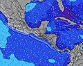 | 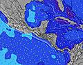 | 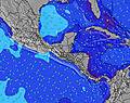 | ||||||||||||
Wave Height (m) Direction Period (s) | SW 18 | SW 18 | SW 17 | SW 16 | SW 16 | SW 16 | SW 15 | SW 14 | SW 14 | SW 14 | SW 14 | SW 13 | SW 13 | SW 13 | SW 13 | SW 12 | SW 12 | SW 15 | SW 14 |
Wave Graph | |||||||||||||||||||
1213 | 1615 | 1597 | 1027 | 1001 | 976 | 905 | 614 | 529 | 456 | 368 | 295 | 245 | 196 | 196 | 120 | 114 | 136 | 248 | |
Wind (km/h) | |||||||||||||||||||
Wind State on-shore cross-onshore cross-shore cross-offshore off-shore glassy | off | off | glassy | off | off | glassy | off | off | off | off | off | off | off | off | cross-off | cross-off | off | glassy | off |
High Tide | 1:54AM1.88m | 2:01PM2.16m | 2:38AM1.99m | 2:43PM2.22m | 3:17AM2.10m | 3:23PM2.27m | 3:55AM2.19m | 4:01PM2.29m | 4:30AM2.27m | 4:38PM2.28m | 5:05AM2.33m | 5:14PM2.24m | |||||||
Low Tide | 7:49AM0.66m | 8:28PM0.42m | 8:33AM0.58m | 9:06PM0.35m | 9:15AM0.52m | 9:41PM0.30m | 9:54AM0.47m | 10:15PM0.28m | 10:33AM0.44m | 10:49PM0.28m | 11:11AM0.42m | 11:22PM0.30m | |||||||
— | 5:31 | — | — | 5:31 | — | — | 5:33 | — | — | 5:33 | — | — | 5:33 | — | — | 5:33 | — | — | |
— | — | 6:13 | — | — | 6:12 | — | — | 6:12 | — | — | 6:12 | — | — | 6:12 | — | — | 6:10 | — | |
mm | — | — | — | 3 | — | — | — | — | — | — | — | — | — | — | — | — | — | 2 | — |
Temp °C | 30 | 33 | 32 | 28 | 33 | 32 | 29 | 35 | 35 | 30 | 35 | 35 | 29 | 34 | 35 | 29 | 33 | 32 | 28 |
Feels °C | 29 | 35 | 36 | 30 | 35 | 36 | 29 | 34 | 32 | 29 | 35 | 35 | 29 | 34 | 34 | 28 | 35 | 36 | 28 |
Swell 1 Height (m) Direction Period (s) | SW 18 | SW 18 | SW 17 | SW 16 | SW 16 | SW 16 | SW 15 | SW 14 | SW 14 | SW 14 | SW 14 | SW 13 | SW 13 | SW 13 | SW 13 | SW 12 | SW 12 | SSW 12 | SW 14 |
1213 | 1615 | 1597 | 1027 | 1001 | 976 | 905 | 614 | 529 | 456 | 368 | 295 | 245 | 196 | 196 | 120 | 114 | 90 | 248 | |
Swell 2 Height (m) Direction Period (s) | WSW 10 | — | SSW 11 | SW 12 | — | S 11 | W 11 | W 12 | W 12 | W 11 | W 10 | S 7 | S 7 | S 7 | SW 16 | SW 16 | SW 15 | SW 15 | S 8 |
9 | — | 25 | 89 | — | 35 | 2 | 3 | 11 | 9 | 8 | 8 | 9 | 10 | 66 | 90 | 77 | 136 | 32 | |
Swell 3 Height (m) Direction Period (s) | WSW 10 | — | — | SSE 9 | — | — | — | W 10 | W 12 | W 11 | WNW 10 | W 9 | W 11 | SW 16 | S 7 | S 8 | S 7 | SSW 7 | SW 18 |
9 | — | — | 26 | — | — | — | 8 | 11 | 21 | 21 | 7 | 9 | 43 | 9 | 10 | 9 | 17 | 50 | |
Wind waves Height (m) Direction Period (s) | SSE 9 | SE 9 | SE 9 | E 4 | SE 9 | SE 8 | E 4 | NNW 10 | E 4 | ENE 3 | ENE 3 | E 3 | E 3 | E 3 | E 3 | E 3 | ENE 3 | ESE 3 | ESE 5 |
52 | 95 | 81 | 14 | 19 | 22 | 20 | 10 | 10 | 3 | 4 | 3 | 5 | 5 | 3 | 7 | 1 | 3 | 12 | |
Nearest Offshore or Glassy | |||||||||||||||||||
Distance (km) | 0 | 0 | 0 | 0 | 0 | 0 | 0 | 6 | 150 | 0 | 0 | 0 | 0 | 0 | 1 | 1 | 0 | 0 | 0 |
Best forecast wave conditions in Leon Province | |||||||||||||||||||
Best forecast wave conditions in Nicaragua | |||||||||||||||||||
Header Global | |||||||||||||||||||
- Map Icons:
 Break
Break Live Wave Height (m)
 Live Wind Speed (km/h)
 Surf Rating (10 Max)
 Ocean Swells (m)
- Wind Speed (km/h)


FREE! Surf-Forecast.com widget for your website
The surf report / weather widget below is available to embed on third party websites free of charge and provides a summary of our Asuchillo Beach Break surf forecast. Simply grab the html code snippet that we provide and paste it into your own site. You can choose your preferred language and metric/imperial units for the surf forecast feed to suit users of your site. Click here to get the code.
Information about the Asuchillo Beach Break Surf forecast
The above surf forecast table for Asuchillo Beach Break provides essential information for determining whether the surfing conditions will be good over the next 16 days. A general guide to surfing at Asuchillo Beach Break can be found by selecting the local surf guide option on the grey menu. Our Asuchillo Beach Break surf forecast is unique since it includes wave energy (power) that defines the real feel of the surf rather than just the height or the period. If you surf the same spot (Asuchillo Beach Break) regularly then make a mental note of the wave energy from the surf forecast table each time you go. Very soon you may start to choose your surf days based on the wave energy alone combined with our forecast of favourable offshore wind conditions. Our star ratings will help here and of course you will also find the usual wave height and period predictions on our surf forecasts as well as a full break down of the swell components under our advanced users option (to reveal that, click the little Einstein character under the tide times).
Further information to help with frequently asked questions about our surf forecast for Asuchillo Beach Break may be found under the help tab on the top menu and also by moving your mouse over the question marks on the surf forecast table itself. Please always bear in mind that the forecast is for near-shore open water and local factors at each surf break influence the actual breaking wave height, such as the beach / reef profile, water depths offshore and shelter.
 Nearest