

Surf Forecasts:

Ampang surf forecast from 5 Jul 2026:
- Most powerful swell: Wednesday 8 Jul, 8PM (local time) - 7ft (2.2m), 16s period, SW swell with 2,291 kJ wave energy.
Best Forecast Surf Conditions for Ampang this week:
The most powerful waves expected at Ampang in the next 16 days are 2.2m 16s and forecast to arrive on Wednesday (Jul 08) at 8PM. Winds are predicted to be cross-onshore at the time the swell arrives. The largest open ocean swell (not directed at the beach) is 0.1m 18s period and expected on Tuesday (Jul 07) at 5PM.
| Wave Type | Time (WITA) & Date | Wave Height & Period |
|---|---|---|
| Next good surf (1 star+) | - | - |
| Best Surf | - | - |
| Most Powerful | 8PM (Wed 8th Jul) | 7ft (2.2m) 16s |
Table - best surf conditions forecast for Ampang over the next 16 days.
Updates in hr min s Forecast update imminent
Alright, Rusty here with the imperial version of that same ugly story.
We’ve got a solid 16-day window, but it’s mostly a write-off for proper surfing. The swell is there, no doubt—running between 3 ft and 7 ft with some strong combined energy in the 1500 to 2800 range—so the ocean’s got plenty of grunt. But the wind is the villain. It’s locked in from the SE to ESE at 15 to 22 mph, a fresh cross-onshore breeze that’s tearing the surface up into lumpy, choppy junk. Every single day is marked as “poor surf conditions.”
The only break in the game is Ampang, a reef that’s already inconsistent. It’s fairly open to the swell, coming mostly from the SSW and SW, but the ideal direction would be SSE, so it’s not perfectly aligned. Water temp is about 82°, pretty normal for this time of year. The swell period is often in the 15-18 second range—that’s long-period groundswell—which brings good energy but also big gaps between sets. With that cross-onshore wind, the waves will be jumbled and hard to ride. Most days have swell over 5 ft, and some push over 8 ft, so beginners should stay out, and even experts will find it messy.
There’s a brief quiet period around July 12th, where the swell drops to about 3 ft and the wind eases to 9-15 mph, still cross-on though, with energy down to 445-500. Slightly calmer, but still not good. Into the second week, from the 18th onward, the swell builds back to 5 ft to 7 ft with strong energy, but the wind stays SE cross-on and fresh, 15-22 mph.
Bottom line: with that constant lumpy wind and choppy water, this setup is more suited to kite surfing than a surfboard. There isn’t a single standout session in the whole outlook—near-term or long-range. It’s a rare blank stretch, and while things can turn, I wouldn’t hold my breath for the next two weeks.
Rusty.
Short Range ForecastMostly dry. Warm (max 28°C on Sun afternoon, min 24°C on Tue night). Mainly fresh winds. | Days 5-7 Weather SummaryLight rain (total 4mm), mostly falling on Wed night. Warm (max 27°C on Wed afternoon, min 24°C on Wed night). Mainly fresh winds. | ||||||||||||||||||||
Sun 5 | Monday 6 | Tuesday 7 | Wednesday 8 | Thursday 9 | Friday 10 | Saturday 11 | |||||||||||||||
PM | Night | AM | PM | Night | AM | PM | Night | AM | PM | Night | AM | PM | Night | AM | PM | Night | AM | PM | Night | AM | |
Swell Height Map |  |  |  |  |  |  |  | 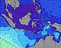 | |||||||||||||
Wave Height (m) Direction Period (s) | SSW 14 | SSW 14 | SSW 17 | SSW 16 | SSW 16 | SSW 16 | SW 15 | SSW 16 | SW 15 | SSW 15 | SSW 16 | SSW 15 | SSW 15 | SSW 15 | SW 16 | SW 16 | SW 15 | SW 15 | SW 14 | SW 14 | SW 13 |
Wave Graph | |||||||||||||||||||||
1301 | 955 | 879 | 949 | 1169 | 1054 | 930 | 1356 | 1663 | 2043 | 2096 | 1963 | 1671 | 1087 | 1693 | 1892 | 1399 | 1212 | 862 | 647 | 299 | |
Wind (km/h) | |||||||||||||||||||||
Wind State on-shore cross-onshore cross-shore cross-offshore off-shore glassy | cross-on | cross-on | cross-on | cross-on | cross-on | cross-on | cross-on | cross-on | cross-on | cross-on | on | cross-on | cross-on | cross-on | cross-on | cross-on | cross-on | cross-on | cross-on | cross-on | cross-on |
High Tide | 2:03AM1.88m | 1:37PM1.91m | 2:36AM1.92m | 2:20PM1.74m | 3:15AM1.96m | 3:16PM1.54m | 4:01AM1.99m | 4:35PM1.35m | 5:00AM2.03m | 6:24PM1.25m | 6:09AM2.09m | 8:14PM1.28m | 7:20AM2.18m | ||||||||
Low Tide | 7:42PM0.36m | 7:53AM0.86m | 8:09PM0.47m | 8:41AM0.85m | 8:37PM0.60m | 9:41AM0.84m | 9:09PM0.74m | 11:00AM0.79m | 9:49PM0.88m | 12:37PM0.68m | 10:49PM1.01m | 2:04PM0.49m | 00:27AM1.08m | ||||||||
— | — | 6:30 | — | — | 6:30 | — | — | 6:30 | — | — | 6:30 | — | — | 6:30 | — | — | 6:30 | — | — | 6:30 | |
6:07 | — | — | 6:07 | — | — | 6:07 | — | — | 6:07 | — | — | 6:07 | — | — | 6:07 | — | — | 6:07 | — | 6:08 | |
mm | — | — | — | — | — | — | — | — | — | — | 1 | 1 | — | 1 | 1 | — | — | — | — | — | — |
Temp °C | 28 | 26 | 27 | 27 | 26 | 27 | 27 | 26 | 26 | 27 | 25 | 27 | 27 | 26 | 27 | 27 | 26 | 26 | 27 | 25 | 26 |
Feels °C | 27 | 27 | 26 | 25 | 25 | 24 | 24 | 25 | 23 | 24 | 23 | 24 | 24 | 24 | 25 | 24 | 24 | 25 | 25 | 23 | 26 |
Swell 1 Height (m) Direction Period (s) | SSW 14 | SSW 14 | SSW 17 | SSW 16 | SSW 16 | SSW 16 | SW 15 | SSW 16 | SW 15 | SSW 15 | SSW 16 | SSW 15 | SSW 15 | SSW 15 | SW 16 | SW 16 | SW 15 | SW 15 | SW 14 | SW 14 | SW 13 |
1301 | 955 | 879 | 949 | 1169 | 1054 | 930 | 1356 | 1663 | 2043 | 2096 | 1963 | 1671 | 1087 | 1693 | 1892 | 1399 | 1212 | 862 | 647 | 299 | |
Swell 2 Height (m) Direction Period (s) | SSW 20 | SSW 18 | SSW 13 | SSW 13 | — | — | W 18 | SSW 6 | SSW 19 | — | SSW 6 | SW 23 | SW 21 | SW 19 | — | — | — | SE 7 | — | SSE 6 | SSE 6 |
76 | 589 | 536 | 414 | — | — | 6 | 4 | 148 | — | 4 | 21 | 72 | 376 | — | — | — | 114 | — | 35 | 31 | |
Swell 3 Height (m) Direction Period (s) | SSW 20 | — | SE 6 | — | — | — | — | — | — | — | — | — | — | — | — | — | — | — | — | SSE 6 | SSW 12 |
77 | — | 85 | — | — | — | — | — | — | — | — | — | — | — | — | — | — | — | — | 30 | 115 | |
Wind waves Height (m) Direction Period (s) | SE 6 | SE 6 | SE 6 | SE 6 | SE 6 | SE 6 | SE 6 | SE 5 | SE 6 | SE 6 | SE 6 | SE 7 | SE 6 | SE 6 | SE 6 | SE 6 | SE 6 | SE 7 | SE 6 | ESE 6 | — |
69 | 54 | 167 | 133 | 96 | 126 | 120 | 71 | 106 | 107 | 103 | 189 | 156 | 118 | 130 | 133 | 106 | 173 | 109 | 15 | — | |
Nearest Offshore or Glassy | |||||||||||||||||||||
Distance (km) | 37 | 7 | 37 | 37 | 6 | 37 | 37 | 7 | 37 | 37 | 6 | 37 | 37 | 26 | 37 | 37 | 26 | 37 | 37 | 7 | 7 |
Best forecast wave conditions in South Coast of Lombok | |||||||||||||||||||||
Best forecast wave conditions in Indonesia | |||||||||||||||||||||
Header Global | |||||||||||||||||||||
- Map Icons:
 Break
Break Live Wave Height (m)
 Live Wind Speed (km/h)
 Surf Rating (10 Max)
 Ocean Swells (m)
- Wind Speed (km/h)


FREE! Surf-Forecast.com widget for your website
The surf report / weather widget below is available to embed on third party websites free of charge and provides a summary of our Ampang surf forecast. Simply grab the html code snippet that we provide and paste it into your own site. You can choose your preferred language and metric/imperial units for the surf forecast feed to suit users of your site. Click here to get the code.
Information about the Ampang Surf forecast
The above surf forecast table for Ampang provides essential information for determining whether the surfing conditions will be good over the next 16 days. A general guide to surfing at Ampang can be found by selecting the local surf guide option on the grey menu. Our Ampang surf forecast is unique since it includes wave energy (power) that defines the real feel of the surf rather than just the height or the period. If you surf the same spot (Ampang) regularly then make a mental note of the wave energy from the surf forecast table each time you go. Very soon you may start to choose your surf days based on the wave energy alone combined with our forecast of favourable offshore wind conditions. Our star ratings will help here and of course you will also find the usual wave height and period predictions on our surf forecasts as well as a full break down of the swell components under our advanced users option (to reveal that, click the little Einstein character under the tide times).
Further information to help with frequently asked questions about our surf forecast for Ampang may be found under the help tab on the top menu and also by moving your mouse over the question marks on the surf forecast table itself. Please always bear in mind that the forecast is for near-shore open water and local factors at each surf break influence the actual breaking wave height, such as the beach / reef profile, water depths offshore and shelter.
Ampang is 27 km (17 miles) from the city of Praya. If you plan a holiday in South Coast of Lombok, look for hotels and other accommodation in Praya. Praya has rooms for a wide range of budgets as well as car hire and transport links.
 Nearest