

Surf Forecasts:

How big are the waves at Tenia today (03 Aug):
- Morning surf: Morning surf (03 Aug, local time) - 8ft (2.5m), 13s period with S swell.
- Afternoon surf: Afternoon surf (03 Aug, local time) - 10ft (3.0m), 12s period with SSE swell.
- Evening surf: Evening surf (03 Aug, local time) - 10ft (3.0m), 10s period with SSE swell.
The current surf forecast for Tenia at 8AM is: 2.5m 13s primary swell from a South direction and 0.4m 15s secondary swell from a Southeast direction, 0.4m 11s secondary swell from a Southeast direction (forecast issued at 04:00am August 03). The wind direction is predicted to be cross-offshore.
| Time (+11) & Date | Wave Height | Wave Period |
|---|---|---|
| Morning (03 Aug) | 8ft (2.5m) | 13s |
| Afternoon (03 Aug) | 10ft (3.0m) | 12s |
| Evening (03 Aug) | 10ft (3.0m) | 10s |
Table - waves today at Tenia. (Swell directed towards the surf break)
Short Range ForecastMostly dry. Warm (max 21°C on Mon morning, min 17°C on Tue night). Winds decreasing (fresh winds from the SE on Mon afternoon, light winds from the E by Wed morning). | ||||||||||||||||||||||||
Monday 3 | Tuesday 4 | Wednesday 5 | ||||||||||||||||||||||
2 AM | 5 AM | 8 AM | 11 AM | 2 PM | 5 PM | 8 PM | 11 PM | 2 AM | 5 AM | 8 AM | 11 AM | 2 PM | 5 PM | 8 PM | 11 PM | 2 AM | 5 AM | 8 AM | 11 AM | 2 PM | 5 PM | 8 PM | 11 PM | |
Swell Height Map |  | 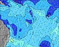 | 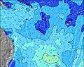 | 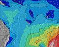 | 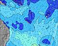 | 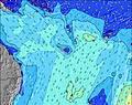 | 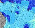 | 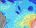 | 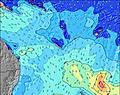 | |||||||||||||||
Wave Height (m) Direction Period (s) | S 12 | S 13 | S 13 | S 12 | SSE 12 | SSE 11 | SSE 10 | SSE 10 | S 11 | S 11 | SE 10 | SSW 19 | SSW 18 | SSW 18 | SSW 17 | SSW 17 | SSW 16 | SSW 16 | SSW 16 | SSW 16 | SSW 16 | SSW 15 | SSW 15 | SSW 15 |
Wave Graph | ||||||||||||||||||||||||
2119 | 2392 | 2185 | 1827 | 2239 | 2268 | 1718 | 1440 | 890 | 815 | 817 | 848 | 794 | 751 | 734 | 717 | 667 | 643 | 590 | 487 | 481 | 451 | 417 | 334 | |
Wind (km/h) | ||||||||||||||||||||||||
Wind State on-shore cross-onshore cross-shore cross-offshore off-shore glassy | cross-off | cross-off | cross-off | cross | cross | cross | cross | cross-off | cross-off | cross-off | cross-off | cross-off | cross | cross | cross-off | cross-off | cross-off | cross-off | cross-off | cross | cross | cross-off | cross-off | cross-off |
High Tide | 10:46AM1.08m | 11:06PM1.29m | 11:31AM1.06m | 11:39PM1.23m | 12:25PM1.04m | |||||||||||||||||||
Low Tide | 4:58AM0.28m | 4:43PM0.26m | 5:34AM0.26m | 5:24PM0.35m | 6:14AM0.26m | 6:12PM0.46m | ||||||||||||||||||
— | 6:28 | — | — | — | — | — | — | — | 6:28 | — | — | — | — | — | — | — | 6:26 | — | — | — | — | — | — | |
— | — | — | — | — | 5:36 | — | — | — | — | — | — | — | 5:37 | — | — | — | — | — | — | — | 5:37 | — | — | |
mm | — | — | — | — | — | — | — | — | — | — | — | — | — | — | — | — | — | — | — | — | — | — | — | — |
Temp °C | 19 | 19 | 20 | 21 | 21 | 20 | 19 | 19 | 19 | 19 | 19 | 21 | 21 | 21 | 19 | 18 | 18 | 17 | 17 | 20 | 21 | 21 | 19 | 19 |
Feels °C | 15 | 15 | 15 | 16 | 15 | 14 | 14 | 15 | 14 | 13 | 14 | 16 | 14 | 14 | 16 | 16 | 16 | 15 | 15 | 18 | 18 | 17 | 16 | 17 |
Swell 1 Height (m) Direction Period (s) | S 12 | S 13 | S 13 | S 12 | S 12 | S 12 | S 11 | S 11 | S 11 | S 11 | S 10 | S 10 | S 10 | SSW 18 | SSW 17 | SSW 17 | SSW 16 | SSW 16 | SSW 16 | SSW 16 | SSW 16 | SSW 15 | SSW 15 | SSW 15 |
2119 | 2392 | 2185 | 1827 | 1602 | 1680 | 1394 | 1116 | 890 | 815 | 374 | 314 | 288 | 751 | 734 | 717 | 667 | 643 | 590 | 487 | 481 | 451 | 417 | 334 | |
Swell 2 Height (m) Direction Period (s) | SSW 20 | SW 20 | SE 15 | SSW 18 | SSW 23 | SSW 22 | SSW 21 | SSW 21 | SSW 21 | SSW 20 | SSE 9 | SSW 19 | SSW 18 | S 10 | SSE 10 | SE 9 | SSE 9 | SE 9 | SSE 9 | SE 8 | SSE 8 | SE 7 | SSE 8 | SSE 8 |
37 | 15 | 59 | 31 | 51 | 183 | 393 | 562 | 666 | 798 | 231 | 848 | 794 | 158 | 164 | 120 | 141 | 115 | 99 | 54 | 74 | 73 | 98 | 88 | |
Swell 3 Height (m) Direction Period (s) | SSW 20 | S 24 | SW 23 | SSW 23 | SSW 18 | SSW 18 | SSE 14 | SE 14 | SE 14 | — | SSW 19 | SE 9 | SE 10 | SE 14 | S 10 | S 9 | S 9 | S 8 | S 8 | S 8 | S 8 | S 8 | S 8 | S 9 |
37 | 11 | 21 | 52 | 31 | 31 | 20 | 8 | 32 | — | 758 | 203 | 142 | 7 | 90 | 83 | 57 | 51 | 35 | 47 | 21 | 12 | 6 | 2 | |
Wind waves Height (m) Direction Period (s) | — | — | SE 11 | — | SSE 12 | SSE 11 | SSE 10 | SSE 10 | SE 9 | SE 9 | SE 10 | SE 10 | SE 10 | SE 10 | SE 10 | SE 9 | SE 9 | SE 9 | SE 9 | — | SE 8 | SE 8 | SE 8 | SE 7 |
— | — | 46 | — | 2239 | 2268 | 1718 | 1440 | 626 | 770 | 817 | 709 | 640 | 188 | 554 | 519 | 447 | 384 | 351 | — | 250 | 320 | 320 | 262 | |
Nearest Offshore or Glassy | ||||||||||||||||||||||||
Distance (km) | 27 | 66 | 1385 | 1379 | 1365 | 1365 | 1365 | 1365 | 1306 | 1266 | 1266 | 65 | 1365 | 1323 | 27 | 3 | 0 | 0 | 0 | 18 | 66 | 27 | 21 | 0 |
Best forecast wave conditions in New Caledonia | ||||||||||||||||||||||||
Best forecast wave conditions in New Caledonia | ||||||||||||||||||||||||
Header Global | ||||||||||||||||||||||||
- Map Icons:
 Break
Break Live Wave Height (m)
 Live Wind Speed (km/h)
 Surf Rating (10 Max)
 Ocean Swells (m)
- Wind Speed (km/h)
Latest Updates


FREE! Surf-Forecast.com widget for your website
The surf report / weather widget below is available to embed on third party websites free of charge and provides a summary of our Tenia surf forecast. Simply grab the html code snippet that we provide and paste it into your own site. You can choose your preferred language and metric/imperial units for the surf forecast feed to suit users of your site. Click here to get the code.
 Nearest