

Surf Forecasts:

Tenia surf forecast from 3 Aug 2026:
- Best quality surf: Wednesday 5 Aug, 2AM (local time) - 3.5ft (1.1m), 16s period, SSW swell with cross-offshore winds.
- Most powerful swell: Monday 3 Aug, 5PM (local time) - 10ft (3.0m), 12s period, SSE swell with 2,433 kJ wave energy.
- Next surfable swell (1★+): Wednesday 5 Aug, 2AM (local time) - 3.5ft (1.1m), 16s period with SSW swell.
Best Forecast Surf Conditions for Tenia this week:
The surf forecast for Tenia over the next 16 days: The first swell (rated 1 star or higher) is forecast to arrive on Wednesday (Aug 05) at 2AM. The primary swell is predicted to be 1.1m and 16s period with a secondary swell of 0.9m and 9s. Another secondary swell of 1.6m and 9s is also forecast. The wind is predicted to be cross-offshore as the swell arrives.
The most powerful waves expected at Tenia in the next 16 days are 3.0m 12s and forecast to arrive on Monday (Aug 03) at 5PM. Winds are predicted to be cross-shore at the time the swell arrives. The largest open ocean swell (not directed at the beach) is 0.7m 5s period and expected on Sunday (Aug 09) at 5PM.
| Wave Type | Time (+11) & Date | Wave Height & Period |
|---|---|---|
| Next good surf (1 star+) | 2AM (Wed 5th Aug) | 3.5ft (1.1m) 16s |
| Best Surf | 2AM (Wed 5th Aug) | 3.5ft (1.1m) 16s |
| Most Powerful | 5PM (Mon 3rd Aug) | 10ft (3.0m) 12s |
Table - best surf conditions forecast for Tenia over the next 16 days.
The Lowdown
Alright folks, Rusty here. Let’s have a proper look at what’s on the cards for the next couple of weeks.
We’re kicking off with a solid pulse of energy, but it’s a bit of a mixed bag. The first few days bring some serious size, but the wind is a real problem. Monday the 3rd has a wave height of 8 ft from the south, with a long period of 12 seconds – that’s proper groundswell. The combined energy is a massive 1910, which is strong to very strong. But the wind is a fresh 30 km/h from the SE, making it a cross-off. It’s clean, but that’s a lot of wind and a lot of water. This is expert territory at 8 ft.
By the afternoon, it gets bigger, hitting 10 ft from the SSE, but the wind picks up to 40 km/h, creating a cross-shore mess. That’s a no-go for paddling – looks more like a kite day.
The real standout for the whole period? It’s got to be the morning of Thursday the 13th of August. After a long run of tiny, poor surf, the swell rebuilds. We’ve got clean 4 ft from the SSW with a 12-second period, giving a combined energy of 559 (moderate). The wind is glassy, dead calm off the SSW. For a reef break, that’s as good as it gets. The water temp is 73°, which is about 0.9° warmer than average, so nothing unusual there. The swell direction is a perfect match for the break’s optimum. This is the one to circle on the calendar. It’s a bit far out, so keep your fingers crossed, but it’s got all the makings of a classic session.
The rest of the first week is a tough watch. After the initial big swell, things drop off fast. Tuesday the 5th has a 4 ft clean wave, but the period is an incredible 19 seconds – very long. That’s a groundswell that will wrap around nicely at Tenia, a reef break, but it will be a bit straight and slow for a beach break. The wind is a moderate 25 km/h cross-off, so it’s rideable, but not the best.
From Thursday the 6th onwards, the surf gets tiny. 3 ft, 2 ft, 2 ft – for a few days it’s just small, clean waves. Friday the 7th and Saturday the 8th are barely surfable, with the afternoon of the 8th turning into a messy cross-on. There’s a big gap of poor conditions from the 9th through to the 12th of August. The swell is flat, the wind is onshore or cross-shore.
Then we hit our standout Thursday the 13th. After that, the weekend of the 16th and 17th sees another pulse of swell. The morning of the 16th is glassy with 2 ft, but by the afternoon it jumps to 7 ft from the SSW. That’s a solid, powerful swell (energy 1120) but the wind is a moderate 20 km/h cross-shore, so it’ll be lumpy. Still, for a bigger wave crew, that’s worth a look. The 17th has 5 ft in the morning, but it’s a cross-on, so not great.
The final days of the forecast, the 18th, are just blown out with strong cross-shore winds. Not our time.
So, to sum it up: the first few days are for experts only, if you can handle the wind. The real gem is the morning of Thursday the 13th of August. Get ready for that one. The rest is a lot of waiting for the next pulse.
Rusty.
Short Range ForecastMostly dry. Warm (max 21°C on Mon morning, min 18°C on Tue night). Winds decreasing (strong winds from the SE on Mon afternoon, light winds from the E by Wed morning). | Days 4-6 Weather SummarySome drizzle, heaviest during Fri afternoon. Warm (max 22°C on Thu afternoon, min 18°C on Thu morning). Wind will be generally light. | ||||||||||||||||||||
Monday 3 | Tuesday 4 | Wednesday 5 | Thursday 6 | Friday 7 | Saturday 8 | Sunday 9 | |||||||||||||||
AM | PM | Night | AM | PM | Night | AM | PM | Night | AM | PM | Night | AM | PM | Night | AM | PM | Night | AM | PM | Night | |
Swell Height Map | 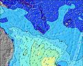 | 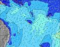 |  | 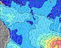 | 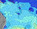 | 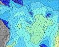 | 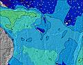 | ||||||||||||||
Wave Height (m) Direction Period (s) | S 12 | SSE 12 | S 11 | SSW 19 | SSW 18 | SSW 16 | SSW 16 | SSW 15 | SSW 14 | SSW 13 | ESE 7 | S 14 | S 12 | SE 10 | SE 9 | SE 9 | SE 8 | SE 9 | SW 10 | SSW 10 | SW 16 |
Wave Graph | |||||||||||||||||||||
1827 | 2433 | 980 | 848 | 751 | 667 | 487 | 451 | 297 | 204 | 133 | 102 | 77 | 134 | 99 | 61 | 166 | 39 | 26 | 38 | 66 | |
Wind (km/h) | |||||||||||||||||||||
Wind State on-shore cross-onshore cross-shore cross-offshore off-shore glassy | cross-off | cross | cross-off | cross-off | cross | cross-off | cross | cross-off | cross-off | cross-off | off | cross-off | cross-off | cross-off | off | cross-off | cross-on | off | glassy | cross | glassy |
High Tide | 10:46AM1.08m | 11:06PM1.29m | 11:31AM1.06m | 11:39PM1.23m | 12:25PM1.04m | 00:18AM1.15m | 1:32PM1.01m | 1:05AM1.06m | 2:58PM1.02m | 2:11AM0.97m | 4:31PM1.07m | 3:38AM0.93m | 5:46PM1.17m | ||||||||
Low Tide | 4:43PM0.26m | 5:34AM0.26m | 5:24PM0.35m | 6:14AM0.26m | 6:12PM0.46m | 7:02AM0.26m | 7:14PM0.56m | 8:01AM0.26m | 8:41PM0.64m | 9:13AM0.25m | 10:28PM0.65m | 10:29AM0.21m | 11:57PM0.59m | ||||||||
6:28 | — | — | 6:28 | — | — | 6:26 | — | — | 6:26 | — | — | 6:26 | — | — | 6:24 | — | — | 6:24 | — | — | |
— | 5:36 | — | — | 5:37 | — | — | 5:37 | — | — | 5:37 | — | — | 5:37 | — | — | 5:37 | — | — | 5:38 | — | |
mm | — | — | — | — | — | — | — | — | — | — | — | — | — | 1 | — | — | — | — | — | — | — |
Temp °C | 21 | 21 | 19 | 20 | 21 | 19 | 20 | 21 | 19 | 21 | 22 | 20 | 21 | 21 | 20 | 21 | 22 | 21 | 21 | 22 | 21 |
Feels °C | 15 | 15 | 14 | 15 | 15 | 16 | 18 | 19 | 16 | 20 | 20 | 18 | 20 | 19 | 18 | 21 | 21 | 20 | 21 | 20 | 20 |
Swell 1 Height (m) Direction Period (s) | S 12 | S 12 | S 11 | S 10 | SSW 18 | SSW 16 | SSW 16 | SSW 15 | SSW 14 | SSW 13 | SSW 13 | SE 7 | SSE 8 | SE 10 | SE 9 | SE 9 | SSE 8 | SE 9 | SE 9 | SSW 10 | SSW 9 |
1827 | 1549 | 980 | 314 | 751 | 667 | 487 | 451 | 297 | 204 | 133 | 43 | 47 | 134 | 99 | 61 | 47 | 39 | 20 | 38 | 32 | |
Swell 2 Height (m) Direction Period (s) | SSW 18 | SSW 22 | SSW 21 | SSW 19 | S 10 | SE 9 | SSE 8 | SSE 8 | SSE 7 | SSE 6 | SE 7 | S 14 | S 12 | S 12 | SSW 11 | SSW 11 | SSW 11 | SSW 10 | SW 10 | SE 10 | SE 10 |
31 | 183 | 666 | 848 | 154 | 118 | 119 | 101 | 66 | 26 | 29 | 102 | 77 | 70 | 41 | 40 | 23 | 20 | 26 | 35 | 34 | |
Swell 3 Height (m) Direction Period (s) | SSW 23 | SSW 18 | SE 14 | SE 10 | SE 14 | S 9 | S 8 | SSW 8 | S 9 | S 16 | S 16 | SW 13 | SSW 12 | SSW 12 | SSW 12 | SSW 15 | SSW 15 | SSW 14 | SSW 13 | SSW 18 | SW 16 |
52 | 31 | 32 | 229 | 7 | 59 | 21 | 7 | 6 | 21 | 44 | 42 | 28 | 14 | 13 | 22 | 21 | 18 | 18 | 31 | 66 | |
Wind waves Height (m) Direction Period (s) | — | SSE 12 | SE 9 | SE 10 | SE 10 | SE 9 | — | SE 8 | SE 7 | SE 7 | ESE 7 | ENE 3 | — | — | NE 3 | — | SE 8 | ENE 2 | — | SE 5 | — |
— | 2433 | 639 | 709 | 188 | 421 | — | 335 | 211 | 119 | 131 | 3 | — | — | 2 | — | 166 | 1 | — | 23 | — | |
Nearest Offshore or Glassy | |||||||||||||||||||||
Distance (km) | 1379 | 1365 | 65 | 1266 | 1323 | 0 | 21 | 63 | 21 | 0 | 0 | 0 | 0 | 21 | 0 | 0 | 21 | 0 | 0 | 1261 | 0 |
Best forecast wave conditions in New Caledonia | |||||||||||||||||||||
Best forecast wave conditions in New Caledonia | |||||||||||||||||||||
Header Global | |||||||||||||||||||||
- Map Icons:
 Break
Break Live Wave Height (m)
 Live Wind Speed (km/h)
 Surf Rating (10 Max)
 Ocean Swells (m)
- Wind Speed (km/h)
Latest Updates


FREE! Surf-Forecast.com widget for your website
The surf report / weather widget below is available to embed on third party websites free of charge and provides a summary of our Tenia surf forecast. Simply grab the html code snippet that we provide and paste it into your own site. You can choose your preferred language and metric/imperial units for the surf forecast feed to suit users of your site. Click here to get the code.
Information about the Tenia Surf forecast
The above surf forecast table for Tenia provides essential information for determining whether the surfing conditions will be good over the next 16 days. A general guide to surfing at Tenia can be found by selecting the local surf guide option on the grey menu. Our Tenia surf forecast is unique since it includes wave energy (power) that defines the real feel of the surf rather than just the height or the period. If you surf the same spot (Tenia) regularly then make a mental note of the wave energy from the surf forecast table each time you go. Very soon you may start to choose your surf days based on the wave energy alone combined with our forecast of favourable offshore wind conditions. Our star ratings will help here and of course you will also find the usual wave height and period predictions on our surf forecasts as well as a full break down of the swell components under our advanced users option (to reveal that, click the little Einstein character under the tide times).
Further information to help with frequently asked questions about our surf forecast for Tenia may be found under the help tab on the top menu and also by moving your mouse over the question marks on the surf forecast table itself. Please always bear in mind that the forecast is for near-shore open water and local factors at each surf break influence the actual breaking wave height, such as the beach / reef profile, water depths offshore and shelter.
Tenia is 54 km (34 miles) from Thio. If you plan a holiday in New Caledonia, look for hotels and other accommodation in Thio. Thio has rooms for a wide range of budgets as well as car hire and transport links.
 Nearest