

Surf Forecasts:

Punta Canoas surf forecast from 26 Jul 2026:
- Best quality surf: Sunday 26 Jul, 2AM (local time) - 3.5ft (1.1m), 19s period, SW swell with glassy winds.
- Most powerful swell: Thursday 30 Jul, 11PM (local time) - 6.5ft (2.0m), 14s period, SSW swell with 1,470 kJ wave energy.
- Next surfable swell (1★+): Sunday 26 Jul, 2AM (local time) - 3.5ft (1.1m), 19s period with SW swell.
Best Forecast Surf Conditions for Punta Canoas this week:
The surf forecast for Punta Canoas over the next 16 days: The first swell (rated 1 star or higher) is forecast to arrive on Sunday (Jul 26) at 2AM. The primary swell is predicted to be 1.1m and 19s period with a secondary swell of 0.9m and 7s. The wind is predicted to be glassy as the swell arrives.
The most powerful waves expected at Punta Canoas in the next 16 days are 2.0m 14s and forecast to arrive on Thursday (Jul 30) at 11PM. Winds are predicted to be cross-shore at the time the swell arrives. The largest open ocean swell (not directed at the beach) is 1.1m 5s period and expected on Friday (Jul 31) at 8PM.
| Wave Type | Time (PDT) & Date | Wave Height & Period |
|---|---|---|
| Next good surf (1 star+) | 2AM (Sun 26th Jul) | 3.5ft (1.1m) 19s |
| Best Surf | 2AM (Sun 26th Jul) | 3.5ft (1.1m) 19s |
| Most Powerful | 11PM (Thu 30th Jul) | 6.5ft (2.0m) 14s |
Table - best surf conditions forecast for Punta Canoas over the next 16 days.
The Lowdown
Alright folks, Rusty here. Let’s take a long hard look at what Punta Canoas has in store for us over the next couple of weeks. It’s a reef and point setup, exposed to the SW, so when the swell lines up, it can be a treat. But we’ve got a bit of a wait on our hands.
Overall, the pattern is a slow build from small, mediocre surf into a slightly more promising mid-week window, followed by a long, quiet fade-out. The first few days are a real struggle. For the standout moment, you’ll want to keep your eyes on Tuesday the 28th and Wednesday the 29th.
That run from Monday the 27th through to Thursday the 30th sees the most consistent energy. The real pick is the Tuesday morning (28th July) session. We’ve got a 5ft SW swell wrapping in with a period of 17 seconds – that’s proper groundswell, and it’s going to hold shape well on this point. The wind is light and offshore from the SW, which is exactly what this break needs. The water is sitting at 68°, about average for the time of year, so nothing wild there. The energy is pumping at a solid 1243 (moderate), so there’s some push behind it. It’s a consistent spot, but crowds are *sometimes* an issue, so get in early. The swell direction is SW, which is the optimum for this break, so it’s all lining up.
Wednesday morning (29th) is a similar story – 4ft SW swell, light offshore winds, energy of 1069 (moderate). It’s a close second. The Thursday afternoon (30th) session also has a bit of kick with 6ft SSW swell and light cross shores, but the period drops to 14 seconds, so it’s not quite as clean as the Tuesday.
A word of caution: the swell is never huge, but by Thursday the 30th the morning swell hits 6ft, which is fine for intermediates, but not really a beginner wave. The short-period SE windswell that pops up on the 7th of August (8ft, 7 seconds) is a complete mess – that’s a kite-surfing setup, not a paddle-surfing one.
After the 31st of July, things drop off a cliff. From the 1st of August through to the 9th, we’re looking at a long stretch of tiny, weak surf with poor conditions. The combined energy sinks to as low as 146 (weak) and the wind is mostly cross-onshore. It’s a real dry spell. Don’t bother planning a trip for that second week; it’s a flat, choppy graveyard.
So, bottom line: the best of the lot is that Tuesday morning (28th July) at Punta Canoas. It’s not a massive swell, but the conditions are clean, the direction is right, and the period is long. Get in the water for that one.
Rusty.
Short Range ForecastMostly dry. Warm (max 23°C on Mon afternoon, min 19°C on Sat night). Wind will be generally light. | Days 5-7 Weather SummaryMostly dry. Warm (max 24°C on Fri afternoon, min 18°C on Tue night). Wind will be generally light. | ||||||||||||||||||
Sunday 26 | Monday 27 | Tuesday 28 | Wednesday 29 | Thursday 30 | Friday 31 | ||||||||||||||
Night | AM | PM | Night | AM | PM | Night | AM | PM | Night | AM | PM | Night | AM | PM | Night | AM | PM | Night | |
Swell Height Map |  |  |  | 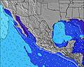 | 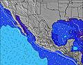 | 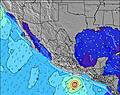 | 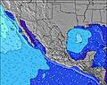 | ||||||||||||
Wave Height (m) Direction Period (s) | SW 19 | SW 18 | SW 18 | SW 18 | SW 17 | SW 16 | SSW 17 | SW 17 | SW 16 | SSW 16 | SSW 16 | SSW 16 | SSW 15 | SSW 14 | SSW 14 | SSW 14 | SSW 13 | SSW 13 | SW 12 |
Wave Graph | |||||||||||||||||||
959 | 742 | 694 | 790 | 974 | 686 | 998 | 1165 | 976 | 892 | 822 | 978 | 924 | 1187 | 1318 | 1428 | 1226 | 983 | 718 | |
Wind (km/h) | |||||||||||||||||||
Wind State on-shore cross-onshore cross-shore cross-offshore off-shore glassy | glassy | cross-on | cross | cross-on | cross-on | cross | cross-on | on | cross-on | glassy | cross-on | cross | glassy | cross-on | cross-on | cross | cross-on | cross | cross |
High Tide | 8:59AM1.45m | 7:27PM2.15m | 9:24AM1.50m | 8:06PM2.22m | 9:48AM1.55m | 8:41PM2.26m | 10:14AM1.60m | 9:15PM2.26m | 10:39AM1.66m | 9:49PM2.21m | 11:05AM1.73m | 10:23PM2.11m | |||||||
Low Tide | 2:20AM0.35m | 1:04PM1.18m | 2:52AM0.27m | 1:46PM1.11m | 3:22AM0.21m | 2:24PM1.04m | 3:50AM0.19m | 3:01PM0.99m | 4:17AM0.20m | 3:39PM0.94m | 4:42AM0.25m | 4:19PM0.90m | |||||||
— | 5:56 | — | — | 5:56 | — | — | 5:58 | — | — | 5:58 | — | — | 5:58 | — | — | 6:00 | — | — | |
— | — | 7:37 | — | — | 7:36 | — | — | 7:35 | — | — | 7:35 | — | — | 7:34 | — | — | 7:32 | — | |
mm | — | — | — | — | — | — | — | — | — | — | — | — | — | — | — | — | — | — | — |
Temp °C | 22 | 22 | 22 | 20 | 22 | 23 | 21 | 21 | 22 | 20 | 21 | 22 | 19 | 21 | 22 | 19 | 22 | 24 | 22 |
Feels °C | 22 | 23 | 22 | 20 | 22 | 23 | 21 | 21 | 22 | 21 | 21 | 22 | 19 | 21 | 21 | 19 | 21 | 21 | 20 |
Swell 1 Height (m) Direction Period (s) | SW 19 | SW 18 | SW 18 | SW 18 | SW 17 | SW 16 | SSW 17 | SW 17 | SW 16 | SSW 16 | SSW 16 | SSW 16 | SSW 15 | SSW 14 | SSW 14 | SSW 14 | SSW 13 | SSW 13 | SW 12 |
959 | 742 | 694 | 790 | 974 | 686 | 998 | 1165 | 976 | 892 | 822 | 978 | 924 | 1187 | 1318 | 1428 | 1226 | 983 | 718 | |
Swell 2 Height (m) Direction Period (s) | WNW 7 | WNW 8 | WNW 8 | WNW 8 | WNW 8 | WNW 8 | WNW 8 | WNW 8 | WNW 8 | WNW 8 | WNW 8 | WNW 8 | WNW 8 | NW 9 | WNW 8 | — | WNW 9 | W 21 | NW 9 |
84 | 51 | 59 | 55 | 59 | 58 | 86 | 88 | 82 | 84 | 92 | 90 | 88 | 75 | 61 | — | 32 | 9 | 38 | |
Swell 3 Height (m) Direction Period (s) | SSW 12 | SW 11 | SSW 11 | SW 13 | SW 12 | SW 12 | SW 9 | WSW 9 | S 14 | SW 9 | S 13 | NW 8 | W 9 | — | — | — | — | — | W 21 |
78 | 30 | 47 | 84 | 71 | 52 | 13 | 8 | 132 | 3 | 160 | 138 | 2 | — | — | — | — | — | 9 | |
Wind waves Height (m) Direction Period (s) | — | — | W 9 | — | — | — | — | — | — | — | — | — | — | — | WNW 9 | WNW 8 | WNW 9 | WNW 9 | WNW 5 |
— | — | 39 | — | — | — | — | — | — | — | — | — | — | — | 25 | 90 | 68 | 121 | 39 | |
Nearest Offshore or Glassy | |||||||||||||||||||
Distance (km) | 124 | 443 | 630 | 107 | 362 | 443 | 243 | 362 | 539 | 84 | 362 | 362 | 107 | 539 | 360 | 124 | 409 | 409 | 324 |
Best forecast wave conditions in Baja Norte | |||||||||||||||||||
Best forecast wave conditions in Mexico | |||||||||||||||||||
Header Global | |||||||||||||||||||
- Map Icons:
 Break
Break Live Wave Height (m)
 Live Wind Speed (km/h)
 Surf Rating (10 Max)
 Ocean Swells (m)
- Wind Speed (km/h)


FREE! Surf-Forecast.com widget for your website
The surf report / weather widget below is available to embed on third party websites free of charge and provides a summary of our Punta Canoas surf forecast. Simply grab the html code snippet that we provide and paste it into your own site. You can choose your preferred language and metric/imperial units for the surf forecast feed to suit users of your site. Click here to get the code.
Information about the Punta Canoas Surf forecast
The above surf forecast table for Punta Canoas provides essential information for determining whether the surfing conditions will be good over the next 16 days. A general guide to surfing at Punta Canoas can be found by selecting the local surf guide option on the grey menu. Our Punta Canoas surf forecast is unique since it includes wave energy (power) that defines the real feel of the surf rather than just the height or the period. If you surf the same spot (Punta Canoas) regularly then make a mental note of the wave energy from the surf forecast table each time you go. Very soon you may start to choose your surf days based on the wave energy alone combined with our forecast of favourable offshore wind conditions. Our star ratings will help here and of course you will also find the usual wave height and period predictions on our surf forecasts as well as a full break down of the swell components under our advanced users option (to reveal that, click the little Einstein character under the tide times).
Further information to help with frequently asked questions about our surf forecast for Punta Canoas may be found under the help tab on the top menu and also by moving your mouse over the question marks on the surf forecast table itself. Please always bear in mind that the forecast is for near-shore open water and local factors at each surf break influence the actual breaking wave height, such as the beach / reef profile, water depths offshore and shelter.
Are you planning a holiday in Baja Norte? If you are looking for accommodation near Punta Canoas, camping, hotels and holiday cottages in Baja Norte, consider staying in Abelardo L Rodriguez which is 50 km (31 miles) away.
 Nearest