

Surf Forecasts:

Port Orford surf forecast from 3 Aug 2026:
- Best quality surf: Tuesday 4 Aug, 2AM (local time) - 8ft (2.4m), 8s period, NNW swell with offshore winds.
- Most powerful swell: Monday 3 Aug, 5PM (local time) - 10ft (3.0m), 7s period, NNW swell with 835 kJ wave energy.
- Next surfable swell (1★+): Tuesday 4 Aug, 2AM (local time) - 8ft (2.4m), 8s period with NNW swell.
Best Forecast Surf Conditions for Port Orford this week:
The surf forecast for Port Orford over the next 16 days: The first swell (rated 1 star or higher) is forecast to arrive on Tuesday (Aug 04) at 2AM. The primary swell is predicted to be 2.4m and 8s period with a secondary swell of 0.4m and 16s. Another secondary swell of 0.3m and 13s is also forecast. The wind is predicted to be offshore as the swell arrives.
The most powerful waves expected at Port Orford in the next 16 days are 3.0m 7s and forecast to arrive on Monday (Aug 03) at 5PM. Winds are predicted to be offshore at the time the swell arrives. The largest open ocean swell (not directed at the beach) is 1.6m 5s period and expected on Friday (Aug 07) at 2PM.
| Wave Type | Time (PDT) & Date | Wave Height & Period |
|---|---|---|
| Next good surf (1 star+) | 2AM (Tue 4th Aug) | 8ft (2.4m) 8s |
| Best Surf | 2AM (Tue 4th Aug) | 8ft (2.4m) 8s |
| Most Powerful | 5PM (Mon 3rd Aug) | 10ft (3.0m) 7s |
Table - best surf conditions forecast for Port Orford over the next 16 days.
The Lowdown
G’day, it’s Rusty. Let’s be straight with you – Port Orford’s looking at a pretty tough stretch ahead. There are waves on offer through the whole 16 days, but the quality is mostly marginal or poor. The real standout comes late in the forecast, so you’ll need some patience.
Right now, Sunday the 2nd into the start of the week, there’s swell in the water – around 8ft from the NNW with a short period of 9 seconds – so it’s lumpy and disorganised. The wind is howling out of the north at 25 mph, strong offshore, which keeps the surface clean and glassy, but it’s a battle to paddle into. The combined energy is moderate at best (1002). Water temp is sitting at a chilly 55°, about a degree colder than normal for this time of year – so you’ll want a hood or a thick suit.
Monday the 3rd and Tuesday the 4th keep that north wind pumping at 22 mph, with consistent 7 to 10ft swell (mostly NNW), but the period stays short, around 7 to 8 seconds. That means choppy, crumbly waves. The energy is moderate (669–903), but the surf quality is poor or marginal across the board. Wednesday the 5th eases off a little – wind drops to 12–16 mph, still offshore, and swell backs down to 6ft from the NW on the afternoon. That session looks actually decent: moderate offshore breeze, clean lines, and combined energy around 451 (moderate). It’s the best of the first week. Thursday morning the 6th also offers 5ft NNW swell with moderate offshore wind (418 energy), but it falls apart in the afternoon and stays poor all through the following days.
Friday the 7th sees a tiny 2ft long-period swell from the SW (13 seconds, energy just 83) in the afternoon – weak and not worth the paddle. Saturday the 8th through to Monday the 10th brings back 6 to 8ft NNW swell, but the wind is fresh to strong offshore (19–25 mph) and the period remains short (6–8 seconds). Surf quality is consistently zero. These are not paddle-friendly conditions – it’s more interesting for a kite surfer if you’re into that.
Tuesday the 11th to Thursday the 13th shows borderline marginal conditions: 8 to 8ft NNW swell, period 8 seconds, fresh offshore winds. The energy climbs to moderate (798–1139). The Wednesday afternoon the 12th and Thursday morning the 13th are the only points where it could clean up into something rideable, but don’t expect magic.
Now, for the true standout. Saturday the 16th morning – that’s the one. A 5ft swell from the west with a very long period of 16 seconds (groundswell, energy a solid 1744). Wind is a moderate 12 mph offshore out of the north. That’s clean, lined-up, and powerful. This is a long-period groundswell, so it’ll be best on the points and reefs around here – Port Orford’s a sheltered NW spot, so keep in mind that west swell might wrap in a bit differently. Still, it’s the best on offer. The afternoon holds at 5ft from the west, 15 seconds, with moderate offshore breeze (energy 1150) – still very solid.
Monday the 17th drops off to 4 to 5ft west swell, long period (12–13 seconds), but the wind picks back up to 22 mph in the afternoon, so the morning is the session of choice.
Crowds at Port Orford are listed as “often” present, so expect company, especially on the cleaner days.
Signing off, Rusty.
Short Range ForecastMostly dry. Warm (max 24°C on Tue morning, min 12°C on Sun night). Mainly strong winds. | Days 5-7 Weather SummaryMostly dry. Warm (max 22°C on Wed afternoon, min 13°C on Fri night). Mainly fresh winds. | |||||||||||||||||||
Sun 2 | Monday 3 | Tuesday 4 | Wednesday 5 | Thursday 6 | Friday 7 | Saturday 8 | ||||||||||||||
PM | Night | AM | PM | Night | AM | PM | Night | AM | PM | Night | AM | PM | Night | AM | PM | Night | AM | PM | Night | |
Swell Height Map |  |  |  | 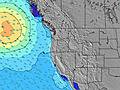 | 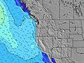 | 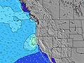 | 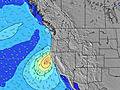 | |||||||||||||
Wave Height (m) Direction Period (s) | NNW 9 | N 7 | N 7 | NNW 7 | NNW 8 | NNW 8 | NNW 8 | NNW 8 | NNW 8 | NW 8 | NNW 8 | NNW 8 | NNW 8 | NNW 8 | NNW 7 | SW 13 | NNW 6 | NNW 6 | NNW 7 | N 7 |
Wave Graph | ||||||||||||||||||||
864 | 493 | 501 | 835 | 672 | 539 | 640 | 643 | 519 | 378 | 271 | 302 | 288 | 270 | 199 | 83 | 182 | 273 | 502 | 679 | |
Wind (km/h) | ||||||||||||||||||||
Wind State on-shore cross-onshore cross-shore cross-offshore off-shore glassy | off | cross-off | off | off | off | off | off | off | off | off | off | off | off | off | off | off | off | off | off | off |
High Tide | 3:22PM2.01m | 3:05AM1.79m | 3:53PM2.08m | 4:01AM1.60m | 4:27PM2.14m | 5:12AM1.43m | 5:08PM2.19m | 6:40AM1.31m | 5:59PM2.22m | 8:22AM1.31m | 7:00PM2.26m | 9:49AM1.41m | 8:08PM2.32m | |||||||
Low Tide | 9:22PM0.56m | 9:19AM0.20m | 10:15PM0.45m | 9:52AM0.41m | 11:15PM0.32m | 10:30AM0.64m | 00:23AM0.19m | 11:17AM0.86m | 1:36AM0.03m | 12:22PM1.03m | 2:47AM-0.14m | 1:45PM1.11m | 3:50AM-0.31m | |||||||
— | — | 6:11 | — | — | 6:11 | — | — | 6:13 | — | — | 6:13 | — | — | 6:15 | — | — | 6:16 | — | — | |
8:37 | — | — | 8:36 | — | — | 8:35 | — | — | 8:32 | — | — | 8:31 | — | — | 8:30 | — | — | 8:30 | — | |
mm | — | — | — | — | — | — | — | — | — | — | — | — | — | — | — | — | — | — | — | — |
Temp °C | 18 | 15 | 20 | 20 | 17 | 24 | 24 | 19 | 24 | 22 | 19 | 21 | 20 | 18 | 21 | 21 | 18 | 20 | 20 | 16 |
Feels °C | 11 | 9 | 13 | 13 | 11 | 19 | 19 | 14 | 21 | 20 | 16 | 18 | 17 | 15 | 16 | 16 | 14 | 15 | 14 | 10 |
Swell 1 Height (m) Direction Period (s) | SW 14 | NW 8 | WNW 8 | SW 13 | SW 16 | SW 16 | SW 15 | SW 15 | SSW 14 | SW 14 | WNW 8 | SW 14 | SW 14 | SW 13 | SW 13 | SW 13 | SSW 18 | SSW 13 | SSW 17 | SSW 17 |
89 | 381 | 120 | 27 | 66 | 65 | 84 | 57 | 38 | 73 | 28 | 116 | 89 | 85 | 83 | 83 | 131 | 65 | 170 | 172 | |
Swell 2 Height (m) Direction Period (s) | S 12 | SW 13 | SW 13 | SW 16 | SW 13 | S 15 | SSW 12 | S 14 | SW 15 | S 13 | SW 14 | SSW 20 | WNW 8 | WNW 8 | SW 18 | SW 18 | SW 12 | SW 16 | WNW 11 | SW 12 |
27 | 45 | 44 | 41 | 25 | 18 | 14 | 37 | 33 | 14 | 71 | 37 | 13 | 12 | 80 | 79 | 54 | 91 | 46 | 22 | |
Swell 3 Height (m) Direction Period (s) | SW 18 | SW 18 | SW 18 | S 13 | S 16 | SSW 12 | S 15 | SSW 12 | W 15 | SSW 11 | SSW 11 | S 13 | S 13 | SSW 19 | WNW 8 | SSW 21 | W 13 | NW 11 | SW 12 | SW 23 |
49 | 49 | 48 | 13 | 20 | 14 | 17 | 14 | 4 | 12 | 12 | 14 | 29 | 36 | 13 | 85 | 31 | 31 | 37 | 21 | |
Wind waves Height (m) Direction Period (s) | NNW 9 | N 7 | N 7 | NNW 7 | NNW 8 | NNW 8 | NNW 8 | NNW 8 | NNW 8 | NW 8 | NNW 8 | NNW 8 | NNW 8 | NNW 8 | NNW 7 | NNW 6 | NNW 6 | NNW 6 | NNW 7 | N 7 |
864 | 493 | 501 | 835 | 672 | 539 | 640 | 643 | 519 | 378 | 271 | 302 | 288 | 270 | 199 | 143 | 182 | 273 | 502 | 679 | |
Nearest Offshore or Glassy | ||||||||||||||||||||
Distance (km) | 1011 | 95 | 459 | 304 | 47 | 110 | 95 | 47 | 47 | 47 | 39 | 47 | 540 | 47 | 110 | 306 | 47 | 508 | 621 | 95 |
Best forecast wave conditions in South Oregon | ||||||||||||||||||||
Best forecast wave conditions in United States | ||||||||||||||||||||
Header Global | ||||||||||||||||||||
- Map Icons:
 Break
Break Live Wave Height (m)
 Live Wind Speed (km/h)
 Surf Rating (10 Max)
 Ocean Swells (m)
- Wind Speed (km/h)
Latest Updates


FREE! Surf-Forecast.com widget for your website
The surf report / weather widget below is available to embed on third party websites free of charge and provides a summary of our Port Orford surf forecast. Simply grab the html code snippet that we provide and paste it into your own site. You can choose your preferred language and metric/imperial units for the surf forecast feed to suit users of your site. Click here to get the code.
Information about the Port Orford Surf forecast
The above surf forecast table for Port Orford provides essential information for determining whether the surfing conditions will be good over the next 16 days. A general guide to surfing at Port Orford can be found by selecting the local surf guide option on the grey menu. Our Port Orford surf forecast is unique since it includes wave energy (power) that defines the real feel of the surf rather than just the height or the period. If you surf the same spot (Port Orford) regularly then make a mental note of the wave energy from the surf forecast table each time you go. Very soon you may start to choose your surf days based on the wave energy alone combined with our forecast of favourable offshore wind conditions. Our star ratings will help here and of course you will also find the usual wave height and period predictions on our surf forecasts as well as a full break down of the swell components under our advanced users option (to reveal that, click the little Einstein character under the tide times).
Further information to help with frequently asked questions about our surf forecast for Port Orford may be found under the help tab on the top menu and also by moving your mouse over the question marks on the surf forecast table itself. Please always bear in mind that the forecast is for near-shore open water and local factors at each surf break influence the actual breaking wave height, such as the beach / reef profile, water depths offshore and shelter.
Port Orford is 74 km (46 miles) from Coos Bay. If you plan a vacation in South Oregon, look for hotels and other accommodation in Coos Bay. Coos Bay has rooms for a wide range of budgets as well as car hire and transport links.
 Nearest