

Surf Forecasts:

Playa Coyote surf forecast from 26 Jul 2026:
- Best quality surf: Sunday 26 Jul, 9PM (local time) - 4.5ft (1.3m), 17s period, SW swell with glassy winds.
- Most powerful swell: Tuesday 28 Jul, 12PM (local time) - 5ft (1.6m), 17s period, SW swell with 1,573 kJ wave energy.
- Next surfable swell (1★+): Sunday 26 Jul, 9PM (local time) - 4.5ft (1.3m), 17s period with SW swell.
Best Forecast Surf Conditions for Playa Coyote this week:
The surf forecast for Playa Coyote over the next 16 days: The first swell (rated 1 star or higher) is forecast to arrive on Sunday (Jul 26) at 9PM. The primary swell is predicted to be 1.3m and 17s period. The wind is predicted to be glassy as the swell arrives.
The most powerful waves expected at Playa Coyote in the next 16 days are 1.6m 17s and forecast to arrive on Tuesday (Jul 28) at 12PM. Winds are predicted to be cross-onshore at the time the swell arrives. The largest open ocean swell (not directed at the beach) is 0.8m 7s period and expected on Sunday (Aug 02) at 12AM.
| Wave Type | Time (CST) & Date | Wave Height & Period |
|---|---|---|
| Next good surf (1 star+) | 9PM (Sun 26th Jul) | 4.5ft (1.3m) 17s |
| Best Surf | 9PM (Sun 26th Jul) | 4.5ft (1.3m) 17s |
| Most Powerful | 12PM (Tue 28th Jul) | 5ft (1.6m) 17s |
Table - best surf conditions forecast for Playa Coyote over the next 16 days.
The Lowdown
Alright folks, Rusty here. Let’s see what’s cooking for the next couple of weeks.
We’ve got a solid run of surf coming up at Playa Coyote, a beach and point set-up that’s fairly consistent and beginner-friendly. The water’s at 86°F – that’s a touch warmer than normal for this time of year, so you’ll be comfortable in a spring suit or just boardies.
The week kicks off strong. Sunday morning, the 26th of July, we’ve got clean 4ft SW groundswell with a very long period of 19 seconds and glassy conditions thanks to a light NNE breeze. This long-period groundswell is pure quality – plenty of energy, good shape, and those long lulls between sets make paddling out a breeze. The combined swell energy is moderate (978). This is excellent surf for the conditions.
Monday morning, the 27th, is another standout. The swell holds at 4ft from the SW, period still a juicy 19 seconds, and again we’ve got glassy conditions. The energy bumps up a notch to strong (1346). This is excellent surf for experienced surfers – the long period will really wrap into the point, offering some nice lines.
Tuesday morning, the 28th, looks like the pick of the bunch. The swell ticks up to 5ft from the SW with an 18-second period, and it’s dead calm – glassy as a mirror. The energy is strong at 1466. This is top-tier stuff for more experienced surfers; those waves will have plenty of push and shape. The afternoon kicks up a bit of onshore breeze, so get on it early.
Wednesday morning, the 29th, keeps the quality rolling with 5ft SW swell and 16-second period, again glassy. This is getting into that sweet spot for decent size and good power. The crowd factor is listed as “sometimes” here, so early morning you might have a bit of company.
After that, the swell slowly backs off through the end of July and into early August. Thursday morning, the 30th, still offers clean 4ft SW swell with a 14-second period, and it’s glassy. After that, we’re looking at smaller days – Friday morning the 31st is 3ft SW, glassy, but the energy is dropping.
There’s a real lull from around Saturday the 1st of August through to Thursday the 6th of August. The swell drops to 1ft and the energy dips right down – we’re talking weak energy readings around 47 to 161. These are not worth paddling out for. It’s a quiet stretch of about 5 days with no real recommendations.
Things start to look up again on Friday morning, the 7th of August, with a clean 2ft SW swell carrying a very long period of 18 seconds. The energy jumps back up to moderate (302), and the glassy wind returns. It’s small, but the period gives it some shape.
Saturday morning, the 8th, we see 3ft SSW swell with a 16-second period and glassy conditions – energy at 450. Getting better.
Sunday morning, the 9th, brings 3ft SW swell, 14-second period, glassy again. That’s a nice little weekend ender.
After that, the surf fades away again heading into the second week of August. Monday, the 10th is just 2ft and the energy drops off.
So, to wrap it up: the absolute best window is Tuesday morning, the 28th of July – that 5ft SW groundswell with an 18-second period and glassy wind is the highlight of the whole outlook. Monday morning, the 27th, is also a cracker. Get out there early before the wind fills in later in the day. The long gap from August 1st to August 6th is a dud, but the swell returns nicely after that.
Stay stoked,
Rusty
Short Range ForecastModerate rain (total 10mm), heaviest on Sun afternoon. Warm (max 30°C on Sun morning, min 25°C on Sun night). Wind will be generally light. | Days 4-6 Weather SummaryHeavy rain (total 23mm), heaviest during Fri night. Warm (max 30°C on Thu morning, min 25°C on Wed night). Wind will be generally light. | ||||||||||||||||||||
Sunday 26 | Monday 27 | Tuesday 28 | Wednesday 29 | Thursday 30 | Friday 31 | Saturday 1 | |||||||||||||||
AM | PM | Night | AM | PM | Night | AM | PM | Night | AM | PM | Night | AM | PM | Night | AM | PM | Night | AM | PM | Night | |
Swell Height Map |  |  |  | 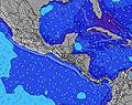 | 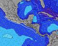 |  | 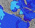 | ||||||||||||||
Wave Height (m) Direction Period (s) | SW 19 | SW 18 | SW 17 | SW 19 | SW 19 | SW 18 | SW 18 | SW 17 | SW 16 | SW 16 | SW 16 | SW 15 | SW 14 | SW 14 | SW 14 | SW 14 | SW 13 | SW 13 | SW 13 | SW 13 | SW 12 |
Wave Graph | |||||||||||||||||||||
920 | 996 | 1062 | 800 | 715 | 1465 | 1213 | 1519 | 1225 | 1194 | 964 | 695 | 529 | 514 | 492 | 357 | 342 | 238 | 238 | 193 | 147 | |
Wind (km/h) | |||||||||||||||||||||
Wind State on-shore cross-onshore cross-shore cross-offshore off-shore glassy | glassy | on | cross-off | glassy | cross-on | glassy | glassy | on | glassy | glassy | on | glassy | glassy | cross-on | off | glassy | cross-on | cross | glassy | on | glassy |
High Tide | 12:23PM2.02m | 1:07AM1.83m | 1:14PM2.08m | 1:55AM1.93m | 2:00PM2.16m | 2:37AM2.04m | 2:42PM2.23m | 3:16AM2.15m | 3:21PM2.28m | 3:52AM2.24m | 3:58PM2.30m | 4:27AM2.31m | 4:35PM2.29m | ||||||||
Low Tide | 6:56PM0.58m | 7:01AM0.73m | 7:43PM0.50m | 7:49AM0.66m | 8:24PM0.41m | 8:33AM0.58m | 9:02PM0.34m | 9:14AM0.52m | 9:38PM0.29m | 9:53AM0.47m | 10:12PM0.27m | 10:31AM0.43m | 10:45PM0.28m | ||||||||
5:30 | — | — | 5:30 | — | — | 5:30 | — | — | 5:30 | — | — | 5:30 | — | — | 5:30 | — | — | 5:31 | — | — | |
— | 6:05 | — | — | 6:04 | — | — | 6:04 | — | — | 6:04 | — | — | 6:04 | — | — | 6:04 | — | — | 6:02 | — | |
mm | — | 3 | — | — | — | 2 | 3 | 2 | — | — | — | — | — | — | 2 | — | 3 | 18 | 1 | 4 | — |
Temp °C | 30 | 29 | 27 | 30 | 29 | 27 | 29 | 29 | 27 | 29 | 29 | 27 | 30 | 29 | 28 | 30 | 30 | 28 | 28 | 28 | 27 |
Feels °C | 33 | 32 | 31 | 33 | 31 | 31 | 32 | 32 | 32 | 32 | 32 | 31 | 32 | 32 | 33 | 33 | 33 | 32 | 33 | 31 | 32 |
Swell 1 Height (m) Direction Period (s) | SW 19 | SW 18 | SW 17 | SW 16 | SW 15 | SW 18 | SW 18 | SW 17 | SW 16 | SW 16 | SW 16 | SW 15 | SW 14 | SW 14 | SW 14 | SW 14 | SW 13 | SW 13 | SW 13 | SW 13 | S 7 |
920 | 996 | 1062 | 546 | 525 | 1465 | 1213 | 1519 | 1225 | 1194 | 964 | 695 | 529 | 514 | 492 | 357 | 342 | 238 | 238 | 193 | 57 | |
Swell 2 Height (m) Direction Period (s) | S 10 | S 10 | S 10 | SW 19 | SW 19 | S 9 | SW 13 | S 9 | S 11 | S 11 | S 7 | S 7 | S 7 | S 6 | S 6 | S 8 | SSW 8 | S 8 | WNW 12 | S 7 | SW 12 |
100 | 98 | 96 | 800 | 715 | 41 | 253 | 25 | 61 | 58 | 24 | 23 | 21 | 13 | 13 | 19 | 19 | 18 | 46 | 23 | 147 | |
Swell 3 Height (m) Direction Period (s) | SW 11 | SW 11 | SW 11 | S 10 | S 10 | SSW 12 | S 11 | SSW 11 | — | — | SSW 10 | S 10 | W 12 | S 10 | WNW 11 | WNW 10 | WNW 12 | WNW 11 | S 7 | WNW 12 | SW 16 |
58 | 41 | 29 | 68 | 67 | 28 | 63 | 25 | — | — | 11 | 7 | 3 | 7 | 12 | 11 | 28 | 25 | 8 | 46 | 124 | |
Wind waves Height (m) Direction Period (s) | — | — | — | — | — | — | — | — | — | — | — | — | — | — | — | — | — | — | — | — | — |
— | — | — | — | — | — | — | — | — | — | — | — | — | — | — | — | — | — | — | — | — | |
Nearest Offshore or Glassy | |||||||||||||||||||||
Distance (km) | 0 | 78 | 0 | 0 | 78 | 0 | 0 | 78 | 0 | 0 | 72 | 0 | 0 | 78 | 0 | 0 | 78 | 45 | 0 | 62 | 0 |
Best forecast wave conditions in Golfo de Nicoya | |||||||||||||||||||||
Best forecast wave conditions in Costa Rica | |||||||||||||||||||||
Header Global | |||||||||||||||||||||
- Map Icons:
 Break
Break Live Wave Height (m)
 Live Wind Speed (km/h)
 Surf Rating (10 Max)
 Ocean Swells (m)
- Wind Speed (km/h)


FREE! Surf-Forecast.com widget for your website
The surf report / weather widget below is available to embed on third party websites free of charge and provides a summary of our Playa Coyote surf forecast. Simply grab the html code snippet that we provide and paste it into your own site. You can choose your preferred language and metric/imperial units for the surf forecast feed to suit users of your site. Click here to get the code.
Information about the Playa Coyote Surf forecast
The above surf forecast table for Playa Coyote provides essential information for determining whether the surfing conditions will be good over the next 16 days. A general guide to surfing at Playa Coyote can be found by selecting the local surf guide option on the grey menu. Our Playa Coyote surf forecast is unique since it includes wave energy (power) that defines the real feel of the surf rather than just the height or the period. If you surf the same spot (Playa Coyote) regularly then make a mental note of the wave energy from the surf forecast table each time you go. Very soon you may start to choose your surf days based on the wave energy alone combined with our forecast of favourable offshore wind conditions. Our star ratings will help here and of course you will also find the usual wave height and period predictions on our surf forecasts as well as a full break down of the swell components under our advanced users option (to reveal that, click the little Einstein character under the tide times).
Further information to help with frequently asked questions about our surf forecast for Playa Coyote may be found under the help tab on the top menu and also by moving your mouse over the question marks on the surf forecast table itself. Please always bear in mind that the forecast is for near-shore open water and local factors at each surf break influence the actual breaking wave height, such as the beach / reef profile, water depths offshore and shelter.
Playa Coyote is 44 km (27 miles) from Nicoya. If you plan a holiday in Golfo de Nicoya, look for hotels and other accommodation in Nicoya. Nicoya has rooms for a wide range of budgets as well as car hire and transport links.
 Nearest